Wednesday, September 24, 2014

Middle Santiam Wilderness Run


BETA
III-IV(V)
18 miles (+6 on reservoir)


Stream: This section flows through the Middle Santiam Wilderness Area and provides an overnight kayaking opportunity for intermediate to advanced boaters.  While the overnight option is the best way to see this section of river, it can also be run in a (long) day, if someone is in a rush or the conditions are too Oregon (i.e. raining, unpredictable flow situation, and cold).  Overall the run is class II-IV, with two class V rapids that can be avoided.  


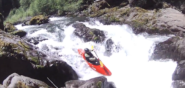
The first of the class V's (The OK Corral) is just below the put in bridge and can be scouted before putting on from the ridge the following photo is taken from.


If you don't like what you see, there is a road on river left with a spur that you can follow down towards the creek, followed by a bushwhack.  I haven't done that, but heard it's not difficult.  Or, people have put in on and run the last 1/4 mile of Lake Creek before, which is on river-right and has road access as well.


Pete Giordano on the day of the first descent of the OK Coral in 2008.

Jake Zwicke exits the O.K. Corral on a more recent 2017 trip.
Photo: Scott Baker


After the OK Corral (a series of ledges leading into a 10-15' exit falls), scout the next tricky boulder garden on the right.  After this boulder garden it's lots of read and run class III-IV, look for a creek entering on the right about a mile down (Lake Creek) with a small but tricky double drop you can hike up to if there is any water flowing down the creek.


More read and run eases off until Geomorph, where an active landslide on river right creates a series of rapids along a river-left cliff.

  The first in the Geomorph series is the largest, and should be scouted.


This series of rapids continues downstream and parts may require scouts depending on flows and wood.

More read and run leads to Shedd Camp Shelter and Shelter Falls.  As the levels come up, it's wise to be on alert above Shelter Falls.  There is a section of boulder bars that ends in a gradual right turn abruptly at this drop, with a brushy eddy on the left (where the un-manned red boat is in the following photo) immediately downstream from where a creek enters on the left.  If you are paying attention you will note the large boulders downstream and have time to make this eddy.

Scott Baker roosting Shelter Falls for his birthday.

  If you are doing this as an overnighter and the weather is bad, this is an optional place to camp in the form of a wood shelter in the forest on river left.  It's pretty early on in the trip though, so if the weather is nice it makes a better lunch spot than camp.

Photo: Zach Urness

  
The hardest drops are behind you at this point, with sustained stretches of read and run making up the rest of the trip.  Below Shelter Falls one of these sustained sections of easier rapids begins, then ends again about the time Pyramid Creek enters on the right a short way after crossing under a bridge, which is nearly the same size as the middle Santiam at this point.  The run takes on more of a river feel and becomes less creeky after this confluence.
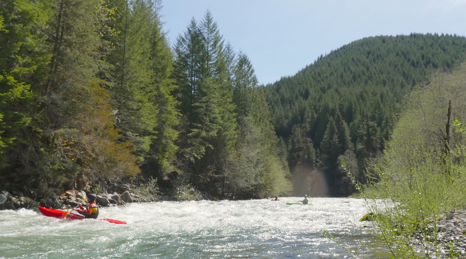


Downstream of Pyramid Creek, a plethora of camping options exist, there are some decent ones early on, but the best ones are in the vicinity of Donaca Creek (which comes in on river right), about 1.5 miles below the Pyramid Creek confluence.

Jesse all smiles in the heart of the Middle Santiam Wilderness.


We camped immediately downstream of Donaca Creek and used it as a water source.  This site had the luxury of getting sun in the evening and morning on our Spring run.


 Camping options do exist downstream, but the big, open gravel and moss benches dwindle quickly below Donaca Creek.


Downstream of the boulder bars the stream consolidates again and enters the heart of the Middle Santiam Wilderness, this section defines scenic.  The forest in here is green, even by western Oregon standards.   The river moves along at the perfect pace through here in the form of mostly class II to III rapids (along with the occasional attention grabber), allowing you to take in what is around you without having to focus much on the rapids or making time.  Do keep an eye out for wood though, it is likely to be present, though don't be surprised if you don't ever need to get out of your boat.

Eventually, a corner is turned and the transition from wilderness into private timber land is obvious.   You may find your attention diverted from the greenery to the large cliffs visible high on the hills.


The whitewater picks back up with some read and fun, a little more exciting than the read and run that has come before.  Nearly every rapid in this section has a good jib feature or two, the smooth rocks make for great boofs, splats, and eddy turns.  Keep your eyes out for the occasional surf and the slalom opportunities as well.
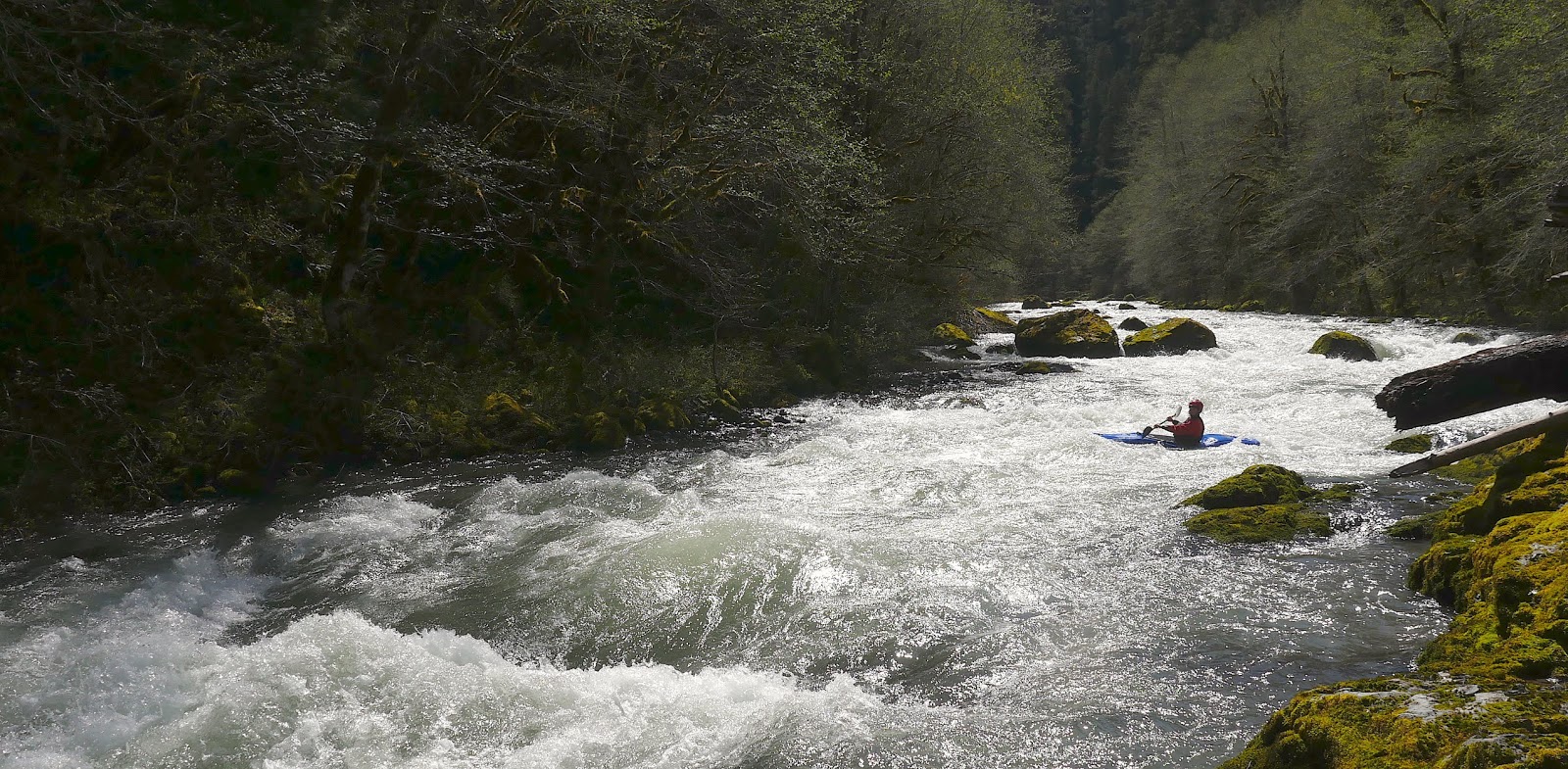


This section eases off but the water keeps moving, over 4' there are no still pools so it's easy to make good time.  Don't forget to grab a snack!  There were newts everywhere both times I did the run, and the fishing is great if levels are low.


After some more cliff viewing, a final barrage of good whitewater begins.  This is my favorite section on the river, everything is boat scoutable and clean.  There is great mixture of friendly hydraulics, maneuvering, boofs, ramps and splashes.

Jesse gets a little of everything in this fun one. 


This last section of whitewater continues for some time, and left a smile on all our faces.  Finally, a bridge is reached near where the lake begins.  If you figured out access to near here it's a short lake paddle to where the vehicles are, but if you left your rig at Whitcomb Park you have 6 miles of flatwater in front of you.  Though chances are reasonable if the boat ramp is open, you might be able to bribe your way into a ride as motorized boat traffic on the reservoir for fishing is common.


While there is some good whitewater on this trip, there is also plenty of lazy floating between.  A great mix for an overnight opportunity.  The run can be done in a day, but with the long shuttle, long run and potential access hurdles I prefer to get the most time out of the run as I can on the rare opportunities that arise to paddle it.  As the only true wilderness run in Oregon's Cascades, with few trails reaching the river, you can count on the only people you see on the river being the ones you paddle in there with.


Flows:  The Middle Santiam has a foot gauge, but no cfs reading as of 2020.  The first of the following graphs show the flow we had on an overnight trip at what I would consider goldilocks flows, not too high, not too low.  The second graph was from my first time down when we did it as a day trip.  The day trip was at the low end of enjoyable, but I'd go back at that flow if it was an overnight opportunity and bring a fishing pole.  In 2017 two other groups did the run at 3.8' and 3.9' (May 20, 2017) and were satisfied by the level.  The highest level I have heard of so far was 5.2 dropping to 5.0 (May 30, 2023) from Willy Dinsdale, he said that felt like a perfect medium-high.  

Goldilocks Flows


Minimal Flows


You can also tinker around with the Inflow to Green Peter Reservoir to guess cfs.  Soggy Sneakers recommends subtracting the Quartzville flow from the Green Peter inflow to get an estimate for the Middle Santiam.  Using that calculation, 900 cfs was minimal and 1,200-1,500 was goldilocks.


Access:   The first thing to do is look the local snotel sites to get a feel for whether the put in road will be accessible.   The two closest are Jump Off Joe and Daly Lake.  The access road is between those two reporting stations, and give a reasonable estimation as to how much snow will be on the road.   The Sheep Creek road is prone to retaining snow drifts.  The logging company does plow up there some years, and has been happy to let us know whether they have done that yet at (541) 367-2111.  You can also try the local ranger district to find out the road conditions. 

And if there is snow on the road, you could always try getting resourceful.
                       Photo: Willy Dinsdale


Take Out:  The easiest take out to find is Whitcomb Creek Park boat ramp (44.477798, -122.507539).  Using this take out requires a 6 mile flat water paddle out, though bribing a ride from a motorboat is often an option if the ramp is open.  There is also a road on the other side of Green Peter Dam that goes all the way to the inlet of the reservoir, but is privately owned by a logging company.  High Deck Rd out of Cascadia is owned by that same company.  You can try and figure out those access routes if you want to reduce the reservoir paddle.  


Put In (44.466549, -122.147259):  Return to Hwy 20 and drive east about 24 miles to NF 2047/Sheep Creek Rd where you turn left.  Follow this road 8.7 miles to a bridge over the Middle Santiam (stay right at 0.3, left at 0.4, center/main at 2.3, right but not hard right at 3.6, then stay left just after, right at 5.9, 7.9 and 8.4).  The last few miles of the shuttle parallels the headwaters of the Middle Santiam

**If you don't like the look of the first gorge below the bridge (the O.K. Coral), there is a road on river left with an old spur leading close enough to the river that a short bushwhack can serve as an alternate put in.
                                 Photo: Willy Dinsdale @ 5.2'


From the Put In:  Once you reach the bridge, walk 1/10th of a mile downstream on the road to scout the OK Corral from the ridge overlooking it.


----------------------------------------------------------------------------------------------------------------------------------------------
Original Write-up
Marathon on the Middle
----------------------------------------------------------------------------------------------------------------------------------------------


The Middle Santiam is known as Oregon's only Cascade wilderness run.  My attempts on the run have been thwarted for various reasons over the last few years so this time I was bound and determined to get in there.  No one I knew seemed stoked on the trip so I loaded up my car with overnight gear, SPOT device and a scooter for shuttle.  Lucky for me I got a call the evening before my trip from Lucas Glick who agreed to join me on the 20 some odd mile run if we could do it in a day as he wanted to get on the Clear Fork Cowlitz the day after.  I unloaded my overnight gear and scooter and agreed to meet early the next morning.

To avoid the hike in and add in some adventure we planned to run the section the Oregonkayaking crew had uncovered a few years ago.  This would add about 5 miles of exploratory kayaking to the run, but allowed us to put in at a bridge instead of doing a hike.  We made good time on the shuttle and found the put in without undue difficulty.

The first hundred yards of the creek are the most stacked and difficult to scout so we hiked up a ridge to get a view of this section.  Lines committed to memory, we got ready to get underway.

**If you don't like the look of this first gorge, continue just under 1 mile past the bridge over the Middle Santiam to the bridge over Lake Creek (flows out of a culvert).  The 1/4 mile from this bridge to the confluence with the Middle Santiam has some issues, but everything is portageable and there is even a fun surprise or two waiting in there. **

 I was geared up first and slid into the water.  The first ledge was class two, I revoked my initial decision to go right when I noticed some obnoxious branches and went for the janky middle chute instead where I promptly pinned.  I tried budging the boat for a minute before Lucas got there, we both tried for another minute but the boat didn't give an inch.  I pulled my skirt and stepped onto a dry rock to my left.  My boat stayed stuck for another minute before coming free.

Glad to get the carnage out of the way early we continued on downstream into the gorge.  The first couple ledges went smooth, then I portaged a weird drop that Lucas ran before we both dropped off the fun exit falls.

The "OK Corral",  It may be short, but it sure was exiting, yeeehaa!
Also a nod to the Oregonkayaking (OK) crew for pioneering this upper section and many other runs in the area.  Boating in Oregon wouldn't be the same without them!

Lucas about to exit the O.K. Corral via a nice 10-15' foot falls.


Below here was a tricky boulder garden that we both fumbled our way through.


  The next couple miles were nice but we didn't have enough water to fully enjoy the rapids.  The area was super cool though!  There was a tantalizing double drop coming in from a creek on the right that would have been good with more flow.  The next major rapid I recall was created by a landslide coming in from the right.

Geomorphology in action.


There were more rapids in this section before we came to Shelter Falls.  This double drop is tough and I chose to portage.  Lucas cleaned up though!


Shelter Falls.

 Lucas seeks the shelter of the pool below.


The next stand out moment came when we were in cruise mode and  I caught a micro eddy just above a malevolent logjam and had to climb back upstream.  Second mistake of the day for me, I was not on top of my game.  We scouted and the jam turned out to be runnable in the middle.  Below here was a section that increased slowly in entertainment value before settling back to boulder bars.

I wish I remembered more but we were moving expeditiously.  If I did the run again I would take two days to appreciate the area.  I do recall an enjoyable class III-IV section with fun rapids that lasts for quiet awhile, ending near the reservoir.  We stopped twice to fish and eat some food.


We paddled about a mile on the lake before being picked up by a motorboat.  

After this we still had time so headed over to the Pure Hate gorge on Quartzville.  That however, is a story for another day.

Video from the Middle Santiam Wilderness run.


MSantiamWilderness from Jacob Cruser on Vimeo.


Lucas and I paddled the run on June 1, 2013


The South Santiam@Cascadia dropped from 1,000 - 800 cfs that day after two days without rain.

Quartzville dropped from 700 - 550 that day.


Thursday, September 18, 2014

Dougan

This is the stream that comes in just below Dougan Falls on the Washougal.  Less than a mile upstream of the confluence the stream branches into two forks, each quit small.  I ran the slides just upstream of the Washougal confluence with Theron Jourdan one wintery day.  If the stream from the forks down was free of wood it would be worth doing once or twice.  It was pretty clean looking last time I was up there at low water.  My dad may have done it once, or maybe he just scouted and told me about it.  Anyway, it could be an interesting section to do in conjunction with the Washougal Falls section.


Sandy

This one is in a lot of PNW guide books and gets run all the time, I grew up near this river and have done countless trips on various sections.  One of the most memorable was an overnight rafting trip starting at Sleepy Hollow and finishing at Oxbow, we camped in the beginning of the Sandy Gorge, which I have also done in kayaks.  Here is a report of my dad and friends running all the guidebook sections in a day.

Sandy River in a Day


SF Yamhill

I took a couple friends down the run starting near the Spirit Mountain Casino, adjacent to HWY 18.  They both swam in the first 100 yards so hiked out through a field.  I ran the next five miles to get the vehicle since we had done a bike/hitchhike thing.  Mostly class 1, a couple of 2's maybe with some willows growing in the creek bed.  I have read about good play at high flows including some surfboarding.  I use this gauge, when its nearing 2000 I know the smaller creeks in the area are at a good level.


Thursday, September 11, 2014

Sunshine (Siletz)

This creek has a place on the "what else can I do" list for Corvallis area boaters.  It used to have an estimate on the WKCC levels page and runs when other streams in the area are high. I think we had about 7,000 cfs on the Siletz gauge.  We initially planned to do Rogers (a scout of Rogers took it off my list, it has dangerous wood and non-captivating rapids), but headed to Sunshine instead.  We accessed it from Valsetz rd.  If you are comfortable with wood its class III-IV, if not its more IV-IV+.  We didn't have many portages and had a good time.  There is one bedrock gorge and the shuttle is easy.  No swims in the group, but one log pin.  Ran with Anna Herring and Michael Freeman.


Thursday, September 4, 2014

Wiki # 11: Pure Joy Gorge on Quartzville

 I took out at the bridge upstream of the Pure Hate Gorge and put in at a spur road a couple miles upstream of that.  I didn't want to miss the ledge I had seen from google satellite imagery and ended up suffering through some devils club and log portaging before the ten foot ledge which was a fun boof into a pool.  Below here was about a mile of class III-IV boulder gardens with wood.

First ledge


There is a quarter mile long gorge that was the main event.  The walls soared overhead and my initial attempt to scout on the left was fruitless.  I relocated to river right and spent the next hour groveling up and down the cliff walls, happy as could be to find a way to scout the whole gorge.  The gorge was all good to go and classy aside from 3 logs which required attention.

 The first was in a narrow rapid that I portaged on the right (not without struggle), just below here was a fun and unique 10' broken ledge/slide.  This needed to be run in control as the outlet of this ran into a small rapid with a log which needed to be portaged.  Luckily the features lined up below the ledge/slide for me to be able to broach myself between a rock and the wall and exit onto the boulder bar in the center of the river.  From this point I was able to walk across the log to shore.


The next move was to get in my boat, paddle around the corner and boof over an exposed rock onto shore, from here I carried down to a pinch where two more logs blocked downstream progress.  These were also located in such a way I could utilize them in the portage, doing an airplane seal launch into a small, but boxed in hole off of one of the logs.

There was one more class III to exit the gorge and a log across flat water I had missed during my scout.  I was able to do an iguana move over the log and I was home free!  Below here were two more log portages and a quarter mile of class III slides leading to the take out bridge.  I jogged the shuttle and headed home, glad to have seen a new section of river with a neat gorge.

If seeing the gorge calls to you, I ran this when Upper Quartzville was at a good medium flow, and this section felt low but safe.  I would suggest shooting for 3000 cfs on the Quartzville gauge (for a winter run).

The name is a play on the Iceland/Greenland conundrum.  We found the Pure Hate Gorge downstream to be totally fun and an enjoyable place (at the right flow) while this Pure Joy Gorge is less than stellar.  However, like many obscure Oregon streams, this run would be enjoyable if free of wood.

Click on photo to enlarge


  -jacob


Thursday, August 21, 2014

Ohanapecosh River

Photo: Clinton Begley


The Ohanapecosh is a great run, one of my favorites.  Spending a weekend up there camping and doing as many sunny laps as can be handled on the lower run is something many of us PNW boaters look forward to each year.

That's not all the Ohanapecosh has to offer though, this page described each of the sections that have been paddled on the Ohanapecosh. I have yet to do them all in a single day (or even a single weekend for that matter), but it would be possible and is something I'd like to do at some point.

Because the points along the river are usually encountered heading upstream from Packwood, and the further upstream one goes the less commonly it is run, I have laid them out that way.  i.e. the first description is of the lowest access point, and the last the highest access point.


----------------------------------------------------------------------------------------------------------------------
Access to NF-1270 take out (if La Wis Wis is closed)
46.6642, -121.6003

From Packwood, travel upstream on Hwy 123 just shy of 5 miles and turn left onto NF-1270.  The river is reached in about half a mile.  *Mark the take out at river level*
----------------------------------------------------------------------------------------------------------------------


-------------------------------------------------------------------------------------------------------------


 Cowlitz River (La Wis Wis to NF-1270)
1.25 miles

I only include this section, because when La Wis Wis Campground is closed it is easier to continue through this section than to hike the road out from La Wis Wis.  The water moves along quickly through class II and III rapids, and the scenery is quality.


-------------------------------------------------------------------------------------------------------------


----------------------------------------------------------------------------------------------------------------------
Access to La Wis Wis
46.677, -121.5834

From Packwood continue up Hwy 12 for 7 miles and turn left into the campground.  Turn right at the bottom of the hill.  Make another quick left and leave a vehicle by the large, covered wood structure.  There are a number of short trails that lead to the confluence of the Ohanapecosh and Clear Fork from this spot.
----------------------------------------------------------------------------------------------------------------------


 -------------------------------------------------------------------------------------------------------------


Secret Camp to La Wis Wis Campground
2.85 miles

This is the most commonly run section of the Ohanapecosh, and has the lowest hassle-factor.  The levels are easy to predict, you put in where you camp, it's usually warm and it is commonly run with no portages. It is one of my favorite sections of any river.

Sliding in from Secret Camp, it's already abundantly clear why this is such a special place.  It's worth taking a look at the first rapid from shore before putting on if you haven't been here before.  Next up are a couple ledges that offer up nice deep boofs that can be scouted if that's wanted.  A 1/4 mile of class II proceeds the log slide, which should be scouted on the left upstream of the class II lead in.  You can tell the rapid is coming up because downstream you can see large, room sized boulders on the right bank and a vertical left wall.  It's a pretty straight forward move to get right, but people who are nervous and clam up at the lip sometimes miss the move and fall off to the left.  This used to be a worst case scenario type of situation, but in 2016 the consequences were reduced drastically when some logs moved.  

However, I'd still rather find myself right of the log than left.
Photo: Clinton Begley

When scouting from the left, it can be tough to see around the corner.  It provides peace of mind knowing its a moving pool.  Run the next rapid along the left wall, it's class III.  The next half mile is read and run class IV and loads of fun.  However there are some small, but sinister sieves to watch out for, so if you are not following someone down they can be worth a peak your first trip through.  If in doubt, stay far away from the banks.  I have three first hand accounts of someone flushing under a rock or sieve in their boat on this run, popping up a few wide eyed moments later.

Meanwhile in the middle of the river, fun lines can be had by all.


At the end of the read and run is Butcher's Block, a rapid that used to get portaged regularly but cleaned up in 2016 and is now regularly run.  This drop is signaled not only by a horizon line, but a slight opening of the canyon and large boulders.  At medium to low flows it's easy to scout on the right.   The main hazard is a large boulder on the right that has water flushing under it.  There is a nice boof just to the left of the boulder, the weak kneed can portage with a little effort on the right.  When the water is up, a slightly more involved portage on the left is the best bet.

 Jesse Shapiro lining up the boof in Butcher's Block


Immediately downstream is Triple Drop, which is scouted on the right after Butcher's Block.  There are numerous ways to enter the rapid, make the call for yourself.  At the end of the rapid the flow piles into a rock, so finish with a strong move to the left (or right) in front of the rock/pillow at the bottom.  Below a 2' boof in the runout to Triple Drop a waterfall and vertical wall can be seen downstream on the right.  Most of the current goes center through the rapid here, but that route is not commonly run due to some sieve hazards.  Most people start with some rock bashing down the right, getting to the far right flow against the wall when possible for a fun slide.

The next rapid used to be my least favorite, but now I rather enjoy it after some high water boulder re-arrangement circa 2016-ish.  Enter with the main flow, eddy hop, read and run or shore scout, regardless finish far left.

Read and run rapids continue until Summit Creek is seen entering on the left (largest tributary to this portion of the river).  Boaters bumble through a small entrance rapid, then downstream are confronted by a clean horizon line.  Drive down the right side of the main current, and don't be afraid to launch a big boof off this beautiful 8 foot ledge.

Below this ledge, it's time to start getting ready to eddy out on the left to scout Elbow Room.  If it's your first time I encourage you to error to the left in the lead in to the point of silliness and scrape down to a scouting eddy on the left before the river falls off a ledge back to the right and into Elbow Room.


Elbow Room is typically run down the left side, and through a narrow crack at the bottom that goes better than it looks like it would during the scout.  There is also a stouter entrance on the right, and a super stout (not recommended) line through the bottom right.

A couple paddlers taking the bold right side entrance.


Messing up the right line has severe consequences.

Video from Cascade Classics

If you would like to portage, head upstream along the shelf from the scouting eddy gaining elevation (watch your footing).  When the vegetation is reached a bit of a trail becomes present, head downstream along this trail a couple hundred yards.  Eventually following it back down to the gorge rim.  The throw and go is the best/most fun option here, but if you don't like jumping there is a way to walk down to river level and have everyone else lower gear to you.  Remember to be a team player here.

Just downstream is a nice bedrock rapid, it's class III on the right and has a class IV double ledge on the left. 

Read and run leads to the signature rapid of the run, Ohanapecosh Falls.  The lead in hole is powerful, but a good stroke will typically get you through.  The further right you hit it, the easier it is to make it through.  The outflow of this hole pours over a beautiful 15' falls.  The left channel is what most people aim for, but the middle line is fine too.  The left side line on the falls delivers the best results if you climb up onto the wall high and early, holding that right stroke until you are airborn and resetting your hips on the way down.

Adam Edwards about to get it good.


The next rapid downstream is Petrified, the most notorious on the run aside from Elbow Room.  There are many fun line options here, scout them for yourself from the left.  The center hole has a reputation for being extremely sticky, though something changed in 2017 and it seems more forgiving than it once was.

Ben Mckenzie adding a little steeze to Petrified.
 Photo: Priscilla Macy


There are a number of read and run rapids below Petrified, but keep an eye out for wood. Things ease to riffles by the time you reach the confluence of the Clear Fork Cowlitz and the take out at La Wis Wis Campground.


Trip Report from 2016 @ 1,200 cfs
Trip Report from 2010 @ 2,000 cfs


 -------------------------------------------------------------------------------------------------------------


----------------------------------------------------------------------------------------------------------------------
Access to Secret Camp

Travelling upstream on Hwy 123 from either of the previous access points or Packwood, you will cross the Clear Fork of the Cowliz via a bridge high over the stream.  Just over a 1/2 mile later turn left onto Hwy 123.  In 2.2 miles NF-44 takes off to the right (stay on Hwy 123), within a couple hundred yards turn left onto an unmarked gravel road that leads to the secret camp.  Kayakers typically use the most upstream campsite.  If you pass under the National Park entrance arch on Hwy 123, you have gone about 100 yards too far.
----------------------------------------------------------------------------------------------------------------------


 -------------------------------------------------------------------------------------------------------------


Ohanapecosh Campground to Secret Camp 
 1.75 miles


Photo: Shaun Riedinger


Ohanapecosh Campground used to be the typical Ohanapecosh put in, but some time ago a landslide occurred and dumped an inordinate amount of wood into the run.  People could avoid the wood by putting in at Secret Camp.  The wood stayed around long enough, and kayaking culture shifted towards classic-only whitewater enough that Secret Camp was established as "the" put in for the Ohanapecosh.

The wood situation has improved quite a bit over the last couple of years, and the upper portion of the run is starting to get done again.  There are still two large log jams that need to be portaged, along with a couple small logs to be dealt with and one rapid that most will portage.  Aside from that, there are many class IV-V rapids in a section of the Ohanapecosh with a more "serious" feel.   Certainly worthwhile for the adventurous boater.

Whitney Butler on one of the good ones above Secret Camp.
Photo: Alex Neilson


 -------------------------------------------------------------------------------------------------------------


----------------------------------------------------------------------------------------------------------------------
Access to Ohanapecosh Campground

Travelling upstream on Hwy 123, you cross under a wooden archway.  Just a bit over a mile turn left into Ohanapecosh Campground, stay right at the first juncture and you will reach the bridge shortly.
----------------------------------------------------------------------------------------------------------------------


 -------------------------------------------------------------------------------------------------------------


Park Entrance to Ohanapecosh Campground
1.7 miles


   In 2013 the Lucas’s, Matt and I decided to add a little variety to our Ohanapecosh weekend and checked out the section starting at the Stevens Canyon road bridge and ending at Ohanapecosh Campground.  The trip started out pretty exciting when we got boxed in above a class VI slot.  Matt saved the day by doing some sketchy climbing up the left wall and roping us up after him.  Just below was a fun drop we named Hawt Fire as we had all been listening to Andrew Bradley yell “Hot Fire” after everything he ran the week before.

We portaged Silver Falls and scouted out the gorge below, which contains two boxed in ledge drops that were good to go and class IV-ish.  *On the flip side we were up there one weekend around 2,000 cfs and there was a bathtub sized log stuck in the second ledge hole the entire weekend.*  Below here things eased off to class II-III with the stand out feature being a travertine warm springs on the left that was too shallow to bathe in, but neat to check out.  To continue below Silver Falls I look for ~1500+ cfs. We took off and vowed not to confine ourselves to the lower Ohane when we came up here in the future.  Hawt Fire has even proven worthy of a park and huck (easy to lap) if you bring a lunch and a fun group on a sunny day.


 -------------------------------------------------------------------------------------------------------------


----------------------------------------------------------------------------------------------------------------------
Access to the park entrance

1.8 miles upstream of Ohanapecosh Campground, Stevens Canyon Rd heads left and through the pay entrance to the National Park.  Thee is a pullout at the intersection that can be used for free.  The bridge is within 100 yards of this intersection.

Instead of putting in at the Park Entrance Bridge, these days we walk in 100 yards before Stevens Canyon road turns left off of HWY 12, thus avoiding the boxed in class VI that gave the Lucas's, Matt and I trouble that first time down.  It's a short/easy walk through old growth (veer to the right side of the gully).


Hawt Fire access
click to enlarge


----------------------------------------------------------------------------------------------------------------------


 -------------------------------------------------------------------------------------------------------------


Panther Creek to Park Entrance
1.8 miles
I have not done this stretch of the Ohanapecosh, it is full of non-hazardous wood amongst gravel bars.  You are floating through the Grove of the Patriarchs though, so if you are not opposed to a number of easy portages it might be worth doing.  It looks like there would be some nice gravel beaches to camp on in this section as well.


-------------------------------------------------------------------------------------------------------------


----------------------------------------------------------------------------------------------------------------------
Panther Creek Access
4.2 miles upstream of Ohanapecosh Campground on Hwy 123, you cross over Panther Creek.  Access to the river is easier a short ways (walking distance) downstream from the Panther Creek bridge.
----------------------------------------------------------------------------------------------------------------------


-------------------------------------------------------------------------------------------------------------


Eastside Trail to Panther Creek
1.5 mile hike
2.1 river miles 

 This is the most adventurous section of the Ohanapecosh that has been documented.   It involves a hike in, some dealing, one involved portage and some fun rapids including a runnable 30 footer.


This section has only been done at lower levels, as one of the portages is tricky even at low water.  So if the Secret Campground section is feeling runnable but manky, this section might be worth checking out for adventurous boaters.  I felt after doing the trip that if the tricky portage changed and became runnable, I would endeavor to run this section every couple of years.

*While hiking in, it is easy to pick off Stafford Falls on Chinook Creek.


 -------------------------------------------------------------------------------------------------------------


----------------------------------------------------------------------------------------------------------------------
Eastside Trail Access
46.8045, -121.5653

3.6 miles upstream of Panther Creek on Hwy 123 is the Owyhigh trailhead, which leads quickly downstream to the Eastside trail.  Continue downstream paralleling Chinook Creek for 3 miles to a bridge over the Ohanapecosh at a double falls.  This is the put in.  If you are handy with a map, you might notice that Hwy 123 parallels Chinook Creek on the shuttle.  If you want to knock off most of the hike, just park anywhere and bushwhack down to Chinook Creek and wade across.  The trail is typically within 50 yards on river right down there.
----------------------------------------------------------------------------------------------------------------------


-------------------------------------------------------------------------------------------------------------


Upstream of the Eastside trail bridge
unknown

 Upstream of the Eastside trail the Ohanapecosh still has enough water to boat, and gradient to create whitewater.  Access would be extremely challenging, but not impossible.  There has been no documentation of trips occurring up there, I imagine it would be an exceptionally difficult trip with hard whitewater and portaging. 


 -----------------------------------------------------------------------------------


Hawt Fire at healthy flows, 1200 or so on the gauge.


  -jacob