Showing posts with label valley of the giants. Show all posts

Thursday, April 10, 2014

Boulder Creek; Siletz drainage


BETA

Stream: While logging is an important and necessary industry in our state, I often wonder what Oregon's Coast Range might have looked like before Big Timber got ahold of it.  

The Valsetz region of the Coast Range is one of the most heavily logged areas in Oregon, but there is one watershed in this area (Boulder Creek) that is still on public land and remains largely unmolested near creek level.  Access is tough, and the run is challenging so not many boaters get in there.  For those that do and have the capacity to appreciate the place for what it is, it is a special trip.  

The ideal put in for Boulder Creek is at the confluence with Bridge Forty Creek, though access to that area is not available to most.  A lower run starting near the confluence with Little Boulder Creek is the likely alternative.  The run starts near Bridge Forty pretty small with some class III-IV and wood.  Within the first mile the stream becomes a sheet of bedrock and turns to the right, at this point eddy out left to scout Boulder Creek Falls.  This big falls has been run twice so far by Matt King and Ben Mckenzie.  The lead in is intimidating and the right side lands on rock.  The whole thing drops about 50' including the lead in.  Aside from the intimidation it has a good line and landing zone.

Matt King is in there if you look close.


Below the falls things clean up a little, with many class IV(IV+) rapids and continued wood hazards.  The further you get downstream, the better the rapids become and the less wood there is to deal with.  The best section is downstream of the confluence with Little Boulder Creek.  

Give yourself as much time as possible on this one, you are in a deep canyon for the second half and will be fighting daylight regardless of how smooth your run goes.  Bring food, water and your sense of adventure.
  
Flows:  You need at least 4,000 cfs in the Siletz for enjoyable levels, 6,000-7,000 cfs is a nice medium.

Access:   The section from the confluence with Little Boulder Creek (44.933920, -123.670526) down to the confluence with the North Fork Siletz (44.920561, -123.696239) is going to be the only section of this creek accessible to most boaters.  If you decide to do that run, I recommend continuing down the NF Siletz to this point:  44.892501, -123.716100 for an additional 3.5 miles of good fun on the NF.

If you want to check on current access, contact the BLM NW Oregon office and ask about access to The Valley of the Giants. You take the same route to Boulder as to the VOTG, crossing Boulder Creek less than 2 miles before you would get to the VOTG trailhead.

To get to the area, first cache the map onto your phone.  Google does not acknowledge the road along the NF Siletz as existing, so you will need to read your map the old fashion way once you reach the turn headed north up the NF Siletz.

Take Valsetz Road out of Falls City, or if it's a weekend you can drive up the Siletz from Moonshine Park.  Find your way along the logging roads to this turn, and head north: 44.878294, -123.708203  From this point Google Maps will not be useful.  Continue on the road, passing by the optional take out down on the NF Siletz here:  44.892354, -123.716192.

Continue upstream 3-3.5 miles until you cross the bridge over Boulder Creek.  Then, refer to the following map to access the lower section of Boulder Creek.  This lower section is still available to boaters most any weekend, and if coming in from Falls City on weekdays too any time fire danger is not high.
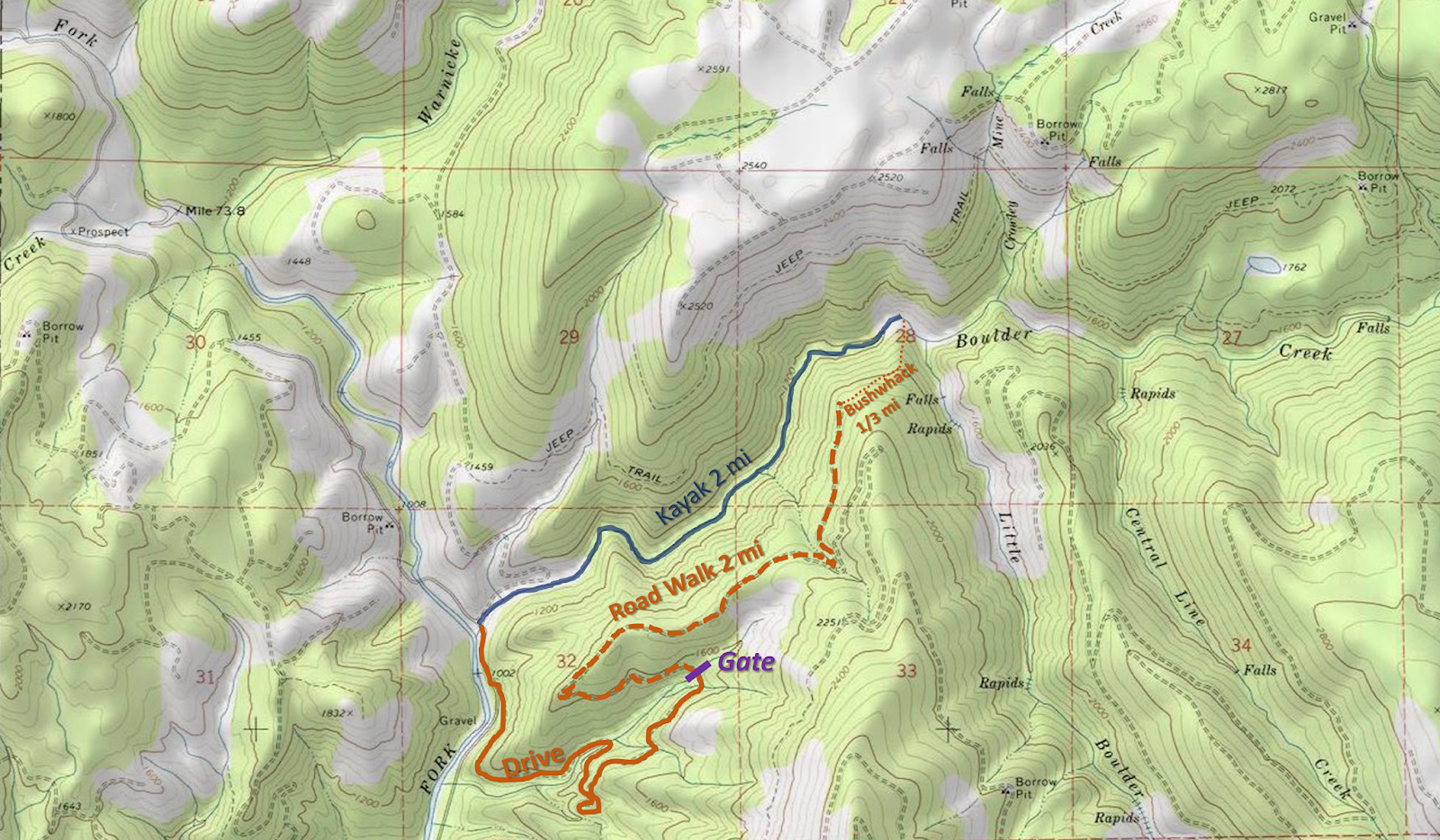


If you want to paddle all of boulder creek, putting in above the waterfall, continue reading.


"The Oregon Coast range is a mountainous version of the Bermuda Triangle.  Gates appear, open, and close randomly.  The famously incomprehensible road system is constantly evolving, so maps are only marginally useful.  Even those who are experienced in land navigation can soon be hopelessly lost without a GPS.  Tourists are regularly swallowed up by these mountains, and sometimes they don't survive the experience.  Needless to say, for those who love adventure, this is a special place."

             ~Jason Rackley; Oregonkayaking.net

For the above reasons I won't be giving step by step shuttle directions.  A summer scouting trip for access is recommended.  If you try to figure out the shuttle for the first time the day you plan to run the creek, you will run out of light.   Valsetz road to the Valley of the Giants has historically been open to the public on weekends when there is no fire danger, expect every other road in the area to be gated and closed except during hunting season.  Though even that option may disappear in 2017. (2019: Valsetz Road is still open). 

Put in:  44.93, -123.6292
Take out:  44.9206, -123.6962

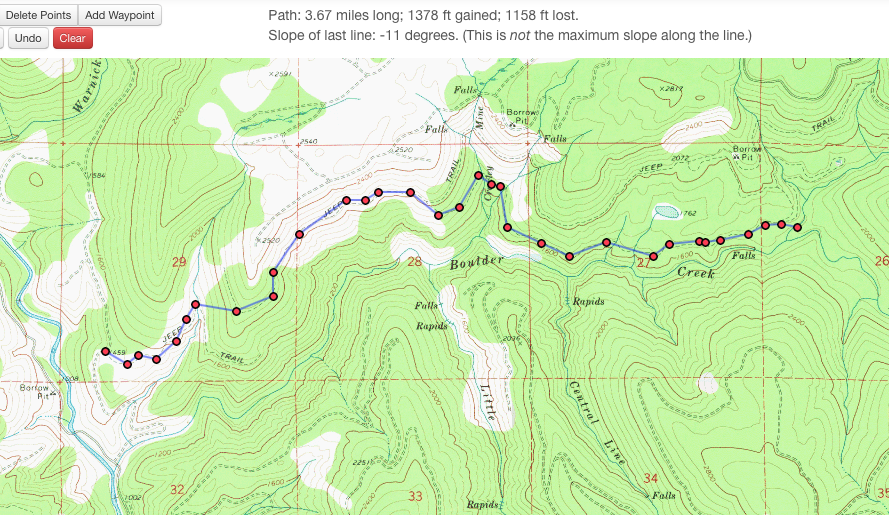
If you can't figure out the shuttle route, there is also the option to hike in from the take out along what the maps label as "jeep trails" along the north side of the creek.  Below are two maps showing those trails.


Click on the map to enlarge it.

The hike is under 4 miles, and after the first mile looks pretty flat.  I do not know the condition of the "jeep trails" other than that around the falls they are good for walking.  I would not be surprised if in some areas they were overgrown.


----------------------------------------------------------------------------------------------------------------------------------------------
Trip Report
----------------------------------------------------------------------------------------------------------------------------------------------


This was my second time down Boulder Creek in the Siletz drainage.  It is an enjoyable but logistically challenging class IV-IV+ run with a tough 50' waterfall that can be portaged.


Paddling in the dark can be very enjoyable under the right circumstances, or it can be very dangerous under the wrong circumstances.  This trip had a little of both.

The first time I did this run with Matt and Eric Harvey we needed to hike in 2 miles through the snow and had to charge on the river to get out before dark.

Photo: Matt King

Snow has a way of creating elegant situations.
Photo: Matt King


This time around everyone was once again pretty excited about running this rarely paddled stream.   All nine of us in fact ( a large but doable number given everyone knew most of the others pretty well).  The meeting time of 8:30 in Monmouth turned into not leaving Monmouth until after 10.

We were in good spirits on the long drive into the NF Siletz drainage.

We ran into another group of boaters doing what looked sure to be a fun run on the NF Siletz.

Shortly down the road we encountered a log across the road that we had beta would be there.  Dan had the foresight to pack a manual chainsaw.

  Time: 11:30   AM

We continued on and made quick time of leaving a car at the take out where Boulder Creek enters the NF Siletz.  We embarked on the long shuttle drive (a little under 15 miles on arterial logging roads).  We didn't need to resort to a map or GPS but having one in the trunk was a comfort.

During this period we encountered logs 2, 3, and 4 that required attention.

  Time:  2:00 PM


We reached the put in parking spot and did the 100 yard walk through the woods into Bridge Forty Creek.  Putting on we encountered a rapid that required scouting and safety.  The hundred yards from the top of this rapid to Boulder itself took 20 minutes due to the small tributary and many boaters.  It would be easy enough to walk straight to Boulder by veering left from the vehicles and skip Bridge Forty Creek.

First rapid, an interesting section of rock and water.

2:25 PM

Upon reaching Boulder it was apparent there was more wood in this upper section than the last time I was here with Matt and Eric.  Everyone started talking about the wood and getting nervous.  The first 200 yards of Boulder really set a precedent as people become timid about hustling downstream due to the abundance of dangerous wood in the creek.

It was not long before we arrived at Boulder Creek Falls.  Many people quickly decided to portage this tough drop.  In the end only Ben Mckenzie was interested in paddling the falls.  He took the same line that I had seen Matt take 2 years earlier which was a right to middle move.  Its a tricky lip with an even tricker and highly consequential lead in.  Ben greased the line.

3:15 PM


It was after 3:30 by the time we were paddling away from the falls and tensions were already mounting.  Below here the stream cleaned up significantly but the woody section from above the falls was still vivid in everyones minds.  We moved slowly through this section and scouted often for wood.


At one point Ben was easing himself under a tree that came loose and landed on him, requiring assistance to hoist it off.

As tributaries came in we started running some quality whitewater and spirits rose a little even as fatigue started to set in.

We had a pin that took some heroic action by Joe to rectify.  This pin put everyone back on their heals.

5:30 Finally Little Boulder came in on the left and I knew that we were in bad shape time wise with dark arriving at around 6pm, but the large group was finally getting into something resembling a rhythm.  We started moving a little quicker and the added volume was welcome, making for some pushy rapids and some holes.


There was a quarter mile long section of pushy boulder gardens that proved to be the tipping point from holding on, to nearing loosing it as a group.  I was chasing down an IK as I entered another rapid and chose to pass the craft instead of try to coral it.  Sam along with Ben arrested it downstream in the first pool we had seen in some time as I headed upstream to check on the paddler.


As I headed that way I saw another boat floating downstream along with its captain.  Ben and Sam once again collected our friend in the pool and the gear as I continued upstream.  The IKer along with two other paddlers made the prudent choice to efficiently portage this rapid.  By the time we were all moving again the light had changed as it was close to dark.

We were in what I remembered as the final gorge.  We had two wood portages in here, at the top of the first portage it was already 6 o clock, the time we had hoped to be off the river by.  We now knew every minute of light was more than we were counting on.

First gorge portage 6:10

After the second portage it was twilight.

Oddly enough, even after the obstacles we had faced and the lack of light, people pulled it together and for the first time we were really moving cohesively as a unit.  I looked back to see everyone in our team spaced evenly and charging ahead as stoically as they could muster.  Had we been moving at this pace and efficiency the whole time, light would never have been a problem.

As twilight faded we encountered the final boulder garden of the run.  I knew if we scouted it we would be running it in the pitch black and saw a line through it so I kept paddling.  The wood situation was worse at the bottom than I had been able to see from above or remembered and two people had close calls.  This was the hardest decision of the day, but I still feel it was better to boat scout the rapid with the last minute of twilight than to run it/portage in the complete dark.

It took a couple minutes to get the group back together and some team encouragement was needed to get everyone back in their boats.  People pulled themselves together for what I remembered as the last rapid (a slide into a hole).  Alex and Ben gave good beta and everyone came through well.

A minute or two after that rapid I took this video.


A ways below here I had a conversation with the unrelentingly positive Sam Causey where he pointed out how now that the rapids were class II, the setting was nearly romantic.  I knew what he meant and relaxed a bit on the 15 minute paddle from here to the take out letting the trip soak in.

Before long I started hearing cheers of joy as people saw the taillights of the take out car (Lucas had hiked back to the cars after breaking his paddle on the first rapid and was about to drive upstream looking for us.)

Everyone regrouped at the cars and the nerves and fear washed away instantly as relief began to set in.

The shuttle went smooth as could be hoped for in the torrential downpour, and everyone took turns recounting the days events.

While from the outside it is hard to see a trip like this as a successful one, those who have been in this situation know that you end up learning a lot about yourself and your friends and while you don't generally seek out that type of ending, there is still a lot to be enjoyed.  On this trip everyone on the team had their roles and executed them when they needed to, Go Team!

  I thought we had got away with one on this trip, little did I know Boulder Creek had left me a little surprise for later that week.


Daylight savings will be a welcome extra hour of light in the evening.

Flows the day we were there averaged in the mid 6k range on the Siletz.

Happy Adventuring,

      -jacob


Thursday, November 14, 2013

North Fork Siletz

The North Fork Siletz is kinda out there so it gets less traffic than some of the more popular runs around Oregon.  It is unfortunate more people don't make the trip because it really is a cool drainage.

The drainage has 4 runs that have a reliable rain fed season.  The North Fork Siletz itself is about as classic as coast range runs come and is what this report will focus on.  The more adventurous runs are described elsewhere on this blog and the internet at large.  The main section is all roadside, has great water quality, 3 bedrock rapids of the class IV-V variety (easily portage-able) and miles of III+ splashy goodness. The area also boasts some of the largest trees in the coast range and you drive through the site of Valsetz if you come through Falls City.  When this town was a thriving logging community, it experienced more days of rain than any other city in the contiguous United States.  The town has now been reduced to a couple foundations.   Every time I visit the Siletz headwaters area it reminds me why I like kayaking so much. 

Photos from Lucas Reitmann and his Gopro.


The run has a write up on Oregonkayaking.  They run it at flood, and this report is at low water.  Most people will shoot for something in between.

At flows above 5' on the Siletz gauge, the best put in option is to walk the short Valley of the Giants trail to a footbridge and put in on that fork.  Within a hundred yards you will be at the confluence with Warnicke Creek and if the gauge is over 7' you will have an enjoyable III+ ride down to the Boulder Creek Confluence.

The photos on this page were taken with the gauge was at 4.5' and we decided to put in on Boulder Creek, about 1/4 mi above the NF confluence.

Below here are some small rapids before reaching the first ledge.  This is the ledge described on the Oregonkayaking report that only Jesse Coombs ran.

At the lower flows we had, it is a benign slide in the middle, or a slightly less benign ledge on the left.  The rapids below here remain small, but the bedrock is intriguing and there are some minor eddies and waves to play in.

Eventually there will be a left turn towards the road, the river then turns right and enters Bombshell Gorge.  It is worth scouting and setting safety on the left.  At 7' on the gauge the first hole is sticky looking.


Lucas enters Bombshell

On our trip at 4.5' there was a sneak route on the left or a tricky twisting ledge drop on the right that produced a couple rolls.


Gabe drops a Bombshell


Victor with an exciting line.


 Below here is a twisting drop and then a hole that might be worth setting safety on.  The easiest way to do this is to have a confident boater run it first and get out on the left.


The small, but sneaky pocket hole in Bombshell Gorge.


Easy pool drop rapids continue below here until what has been referred to as the recommended portage.  It would be possible to unknowingly enter this unassuming drop from above so its worth familiarizing yourself with the area on the shuttle.  We scouted for awhile and Lucas said he wanted to run it but like the rest of us was worried about there being a rock in the chute.  Priscilla and I paddled over to river right and got a big stick.  We probed the depths a few times and determined there were no obstructions hiding beneath the surface.

Lucas then decided to give it a go. He came in and submerged briefly before riding out a tailstand in his Dagger Axiom.


 It was an inspiring line.


  Inspiring enough in fact to start to make the rest of us interested in the drop.  Victor was heading up to his boat almost immediately after Lucas came through.  Lucas called across the stream that it was good to go and we should give it a shot.  Victor then floated into the chute, also submerging and coming out upright.


Recommended portages are often of the grandiose variety.  This one is a compact model.


I followed Victors approach and floated into the chute, letting the water funnel me into the deepest part of the channel and using a rudder stroke I skipped through like everyone else.  Lucas was quick on my tail for a second lap and came through this time without even getting his head wet.  It looked to me from downstream like he drove harder right and took a big stroke.

We took out here and Lucas did the scooter shuttle.  While standing around it was decided this drop should have a name.  It has only been referred to as "the recommended portage", but given Lucas's volition to go first, along with a second successful attempt we devised a name that we felt was ever so clever.

We dubbed the drop "Go Reit, mann"  as the line is to go right, and Lucas's last name is Reitmann.  

 Lucas fire's up "Go Reit, mann" again.
As Nate later pointed out, it's best said in a Jamaican accent. 


There is even a bonus side slide.

Video of the day from Lucas.


NF Siletz from Lucas Rietmann on Vimeo.


 ~1000 cfs is the minimum for this run, 5'-7' on the Siletz gauge provide ideal flows.  If you are looking for a more full day with plenty of class IV(V) and the level is over 4,000 cfs (7ish ft) check out Warnicke Creek.  You can start above Golden Goose and run through Go Reit, mann for an extended day of very fun boating.  Lastly, if water is super high, a combo run of this and the south fork is worth looking into.

   -jacob

Thursday, May 30, 2013

Valley of the Giants

 All photos by Emile Elliot


The NF Siletz drainage has provided a wealth of exploratory style boating.  The main stem itself is fun and roadside, but then you get Boulder and Warnicke which are great trips too!  The last section for me to try out was the Valley of the Giants section which is mentioned in one of the guidebooks.  I tried to solo it one day, but got to the top of the big boulder garden (Golden Egg) and having just promised my dad I wouldn't do anything stupid while he was in the hospital decided to hike out and come back with others.

Emile Elliot and Ben Mckenzie decided they would take a risk to check it out and I'm glad they did!  It was great to finish up the stuff I wanted to check out in the NF Siletz zone and see this section of stream.

The scariest part of this run for me was hiking across the broken bridge on my initial attempt.  This time it was a lot less scary as I knew it would hold.

If care is taken, its not too bad.


There is a short hike in before putting in just above some tantilizing bedrock.  

This class four rapid goes around the corner to the right. 

Its a fun sliding affair.

 When a small waterfall came in on the left we got out to scout on the right.  Locating our next eddy on the left got us to a position to scout Golden Egg.

Getting left towards the small eddy above Golden Egg. 

 It was an easy scout on the left.  This was a good class IV/V boulder garden, but wood in the runout required scrambling into an eddy on the left.  I was not up to the task this day so agreed to catch Ben and Emile as the came into the eddy.  Everything went well and the rapid looked fun, I may have to go back and run the Golden Egg some day.

Ben enters on the right.

Ben takes his navigates his yellow egg through the rapid.


 Below here the run is more like what you expect from Oregon streams, bouldery class IV with intermittent log issues.  All the portages were easy and there was enough whitewater to keep us entertained.  Soon enough we went under the hiking bridge for the valley of the giants hiking trail.  The confluence with Warnicke was shortly after this and we splashed our way down to the take out before walking back to Emile's new truck.

While there are higher quality runs in the drainage, this one is still probably worth the trip for the adventurous boater.  For the right person, it could be a fun full day getting both the Golden Goose and the Golden Egg by doing Warnicke, then follow that up with Valley of the Giants down through the NF run.  I'd suggest considering doing the quick Valley of the Giants hiking trail too if you like that sort of thing.

Here is Emile's video of the trip.  He assures us the song in no way indicates male affection towards one another and in fact was chosen for the reference to a valley :)


The Valley from Difficult E on Vimeo.


   -Jacob

Sunday, April 3, 2011

Warnicke

I had my usual difficulties getting people to come on this exploratory trip, luckily Stephen Cameron caught a whim and joined.

This stream is part of two forks that join the headwaters of the NF Siletz.  When I came to school 3 years ago this was the first stream that caught my attention because of an obvious waterfall on the topo maps.  After learning the nature of access in the coast range I new this one would be a challenging stream to check out.

Last weekend, I passed on a trip to California and instead scouted out the headwaters of the NF Siletz.  I knew Boulder creek was up here and I wanted to check that out, plus I wanted to check out the access situation on Warnicke, while at the same time getting a look at the Valley of the Giants fork of the NF Siletz and take a hike through some of the few true old growth stands remaining in Oregon's coast range.

My scouting trip was a larger success than I had expected.  Gates were open, roads went farther than I expected, it looked like this stream could be done without excess effort.  Another thing I noticed was the geology was promising.  Trip reports of the NF Siletz left me with the impression it would not be worth the effort, but the guidebook run actually looked good too.

The highlights of this trip were hiking through the Valley of the Giants, which is where I saw Warnicke for the first time, as well as some very large trees.  Second was discovering the road up Warnicke had an open gate.  I started driving up this road and made it about a mile in the course of half an hour.  There were a ton of limbs and rocks to move off the sloppy road and my Civic has little clearance.  I eventually turned back, satisfied that the road went far enough to make a trip worthwhile.

Levels lined up perfectly the next weekend, so after Stephen arrived in Monmouth, we made the long drive into the coast range.  We decided to only bring one car and jog shuttle, which turned out to be the right call.  We made it two miles before the road bermed out, leaving us with a 2 mile hike to the put in.

The hike was pretty tame.  We hiked along an old, slightly grown over logging road with a couple easy-to-nagotiate washouts.  Dragging was possible, though we stuck to our backpacks. Eventually we decided to just shwack down to the creek instead of going all the way to the bridge which turned out to be an interesting call.  We ended up putting in just below a large class five rapid and upstream?  Slides as far as the eye could see.  Since neither of us were very interested in the drop it was a mixed blessing putting in where we did.  We missed out on what looked to be fun slides between us and the bridge, but we didn't have to portage this drop.

*to those that like this sort of drop, it is completely runnable, no wood or sieves and not too scary, just very class V.  Had our favorite probe unit not just moved to Eastern Oregon I'm sure it would have been run.  It can be scouted from the right very easily, but hardly at all from the left where we were.

  Andrew Bradley and I returned and ran this drop in 2012.  Its totally good to go and fun.


In 2012 the CCC went in and got a few more descents of the Golden Goose.  Unfortunately one of these resulted in a dislocated shoulder.

  Lucas Glick with a good line.
Nick Chambers photo


Stephen and I liked what we were seeing geology and water level wise as we floated into the class III stuff below Golden Goose.

Just around the next corner started a mile of quality boating.  Class IV boulder gardens with hardly any wood and really fun.  Steep and continuous. There were lots of 3-4 foot boofs and fun moves.  Every horizon we were waiting for another waterfall, but one never did materialize.  We probably only scouted twice in this section as Stephen brought his slalom skill set to the run and made it so we hardly had to get out at all.  If Stephen had not been on the trip, I would likely have been scouting more.

After the end of this mile was a log portage.  The next mile was III-IV with another log portage, and the last mile was III+ with another portage.  All portages were easy.  Stephen did have one interesting portage by seal launching five feet off a log midstream that went well.

Stephen did almost have to drop into a rapid blind when he ran out of eddies, but was able to catch some slack water along the left wall and saw that the drop went, it turned out not be a big issue, but was exciting for a moment.  This is the drop he runs the bottom part of in the video (He eddied out part way down to let me get a shot as I had already jumped out of my boat when I saw things weren't going to plan).

Speaking of video, this was the only shot I got because we were cruising pretty quickly down the run.

The creek was fun all the way to the confluence with Valley of the Giants fork.  The final drop was an island and as Stephen said about his run "I just ran an unrunnable drop, got stopped by that hole, then ducked a log".  If someone else does this, don't worry, its not as bad as it sounds ;)

From here we had a mile and a half of high quality class III down to the confluence with Boulder Creek, where we took out.  We then "jogged the shuttle", and headed home happy about our accomplishments.

--------------------------------------------
NOTES

-Stephen mentioned how un-epic this trip was.  If there was vehicle access to the top, there would be no reason not to run this thing often when the chance arose.

-I know there are not a lot of paddlers out there who like this type of run, but there are some, and if you want to see a new run that is pretty fun without much work involved, check this run out when the Siletz gauge is over 4,000 cfs.

-This area is the rainiest place in the lower 48 that has a gauge (google Laurel Mtn.).  I have been tricked by nice weather in the Willamette Valley more than once and dressed accordingly only to show up to rain in this area of the coast range only 30 miles to the west.

-You also drive through Valsetz if coming from Portland, which was once the rainiest city in the lower 48. (it is no longer a town)

-Jacob