Friday, May 4, 2012

An Earth-bound quest for the celestial: Return to Wiki #1

Photo:  Emile Elliot


This creek has been gaining attention as the season nears its end.  The final quarter mile of boulder gardens (Smokin' Aces) has proved a force to be reckoned with.

Matt King runs Smokin' Aces on our initial exploration of the canyon last year.

 While this section of whitewater is fun, it is best experienced as icing on the cake after a run starting from Black Hole Falls.

One of the gorges on the middle section.
Photo: Matt King


For my third run of this creek, I joined a crew Andrew Bradley had conglomerated with high hopes of running Black Hole Falls.

For this trip John Edwards, Emile Elliot, Anna Herring, Andrew Bradley and myself camped at the take out the night before anticipating the adventure taking all day.  This approach turned out to be the right call as we hit snow almost 4 miles from the end of the road.  Emile got us 1/4 mile closer by some impressive charging in his truck, but sooner than later we resided ourselves to hiking the road.  Having anticipated this as a possibility, we dawned our various kayak shlepping devices and headed into the mountains.


Photo:  Emile Elliot

With only one short detour and a quick stop to fashion some low tech crampons for Andrew we arrived at the end of the road and the beginning of the bushwhack.

This is a lot steeper than I expected, are you sure that was the right road...?
3200'
Photo:  Emile Elliot

Andrew upgrading his footwear and testing them out.
Photos:  Emile Elliot


 Carrying kayaks down 30+ degree slopes is not something most people practice and this was apparent as we watched our precious hours of daylight tick by.  People pushed through the pain [Andrew had something colorful to say whenever we gave him a chance, we appreciated the positive moral :) ] and around two hours after starting our 3/4 mile bushwhack, we arrived at a bedrock laden creek.  There was a presence of wood in this upper section, but it was mostly out of the way and easy to deal with.

Put-in
Photo: Emile Elliot

We hiked upstream to run two fun bedrock slides before a short log portage placed us above another horizon.

First rapid, fun and straight forward.
photo: Emile Elliot

 The next half mile was horizon after horizon of easy, but oh so fun slides and ledges of all varieties.

Andrew lookin' fly
photo: Emile Elliot

Next two photos shot by Andrew Bradley

After leaving this series of fun rapids (The Asteroid Belt), a tributary came in on the right signaling the big falls.

This drop was tricky to scout, with an exposed climb right at the lip of the falls.  Andrew and I forgo this move and waited to hear back from the others.  On this day the falls was too low, with a green water landing (the landing itself is not visible from the scouting platform).  We made quick work of the climb to the trail on river right and took advantage by following the path to the pool below the falls.  We enjoyed the scene for awhile, paddling below the falls before continuing on.  Many more fun bedrock rapids continued, usually dropping about ten feet in various ways.

Two rapids stood out in this stretch.  The first was a fun double boof with a log below that made it a tricky undertaking, but everyone who ran it had upright lines.

Photo: Emile Elliot

 The next was a narrow slot-ledge on the right that looked pretty angry, which Emile apparently had no reservations towards.  He paddled right up and got stopped quickly by the hole at the base and began an impressive surf.  The boxed in hole below was not as wide as a boat is long, and he was pinned sideways twice, once upside down.  He fought through both of these, but once it was apparent he was not coming out in his boat, gave the signal and pulled his skirt.  We got him a rope and pulled him out using a non-traditional approach and were able to get him and his gear to shore safely.  We dubbed this one Solar Flare*.  Emile continued to lead the charge after this and we cruised down some read and run.

Shortly below here we came to the traditional put-in I had used before described in the initial trip report.  From here down it was apparent to me just how low the water was, as well as how low energy levels were becoming.    We took advantage of the trail once again to portage the V+ gorge and ran a few more good rapids that benefit a lot from twice the flow. We had the second swim of the day occur in a class two pin, really bringing to light the toll the long day had taken on us.   Eventually we reached the great wall signaling Smokin' Aces.  We ran the lead in and after recovering a paddle from an ill fated trip a few weeks back we found ways to get out on the right and look at the biggest boulder garden of the run.  The low water lead us walking around on the right.  There is also a wood sieve on the bottom left that was not there when Matt and I ran the drop on our first run.

We tried our best to keep it together through the last two boulder gardens, everyone fought hard, staying in their boats and soon enough we were walking through camp to nourishment at our cars!

Emile edited a video capturing many of the highlights of the trip, including his first swim in over ten years!


Wiki Creek #1 from Difficult E on Vimeo.

It was a long day and everyone was beat by the end.  Attitudes stayed positive the whole trip and the day went smoothly/according to plan.  Even the two swims were taken care of quickly. We also had a very small number of log portages, I only recall 2 or 3 near the beginning of our trip.  From the sounds of it, we all plan on returning sooner than later to once again enter the adventure, and see the rapids with more water.  I have chalked this up as my favorite trip of the year, and the satisfaction has kept me charging through mid-terms here at Western.  This trip has reminded me to never shy away from the unknown in favor of the known.  For I find the rewards of adventure far outweigh anything else I have done in a kayak.


photo: Andrew Bradley


*The solar cycle resulting in flare's is 11 years, and the last time Emile pulled his skirt was over a decade ago. 
 = Solar Flare is name of the drop


   -Jacob


cc@650
want cc 1,000-2,000
900 min.

Thursday, May 3, 2012

Old Man McCoy

With a busy work week and an impending trip to California, I don't have the time to write up a full post, but I will say this:

McCoy Creek is cleaner than it has been in years!

Our crew of four put on the creek Saturday morning with trepidation. The Cispus was hovering right around 3100cfs, which would make McCoy higher than we had heard of people running it, and the last group who attempted the creek reported over 30 wood portages. Arriving at the put-in and seeing the creek wasn't in flood, we did a quick pow-wow and decided to to give er a go. We noted that there were no log portages in sight, a positive sign which strongly influenced our decision to put-on.

All in all, the creek was a blast. Plenty of big drops and unique rapids to keep you busy. We portaged logs 5 times on McCoy and Yellowjacket combined and none of the portages ruined rapids.

The flow turned out to be a double edged sword. The majority of the creek benefited from the extra water; however, Chinook Falls was too big for our taste. We opted to do an extended portage on river left that required a short rappel, but wasn't too taxing. Chinook, with the proper level, looks to be one of the best pieces of whitewater I've ever seen.

We ended up leaving our boats below the 25 foot vertical falls (just above the portage) and hiking off the creek when a member of our crew dislocated his shoulder. 3 of us returned the following day to retrieve our boats and finish the creek. Unfortunately, the one boat remains in the canyon. I carried the Jefe through a majority of the portage and anchored it to a tree just above the ledge that leads back down to creek level below the falls. For the time being, it serves as great marker to better signal the correct portage route.

I did shoot some video, which I'm hoping I can throw up here in the coming weeks.

Note: The very first rapid you hit after putting on is deceptive. It occurs at the first right bend in the creek bed. Two members of our group flushed into a nasty crack in the center of the river that isn't visible from above. Both disappeared for a good second or two and emerged upside down in the manky run out before rolling up. Run this drop on the far right to avoid a similar fate.

-Nate

Friday, April 27, 2012

Little Klickitat Video

Emile brought his helmet cam along on our recent trip to the Little Klickitat River.  He got a ton of footage and edited it down to just over 5 minutes.  

Trip report from Nate.

Here it is, thanks Emile!


  -Jacob

Little Klickitat@ Wahkiacus  ~1300

Saturday, April 7, 2012

TR: Abiqua Creek headwaters


I was curious about seeing the uppermost section of Abiqua Creek, so hiked in 3.5 mile past the yellow gate on Crooked Finger Road, a good bit of which involved post holing through the snow to a confluence just downstream of a bridge (44.8781, -122.4453).

With 400 cfs in Butte Creek, this section was far too low.  But for me it was about seeing it, so despite it being rough on my boat and hitting more rocks than boofs, I enjoyed myself.  The rapids were almost entirely boulder gardens. 

Access:  Follow Crooked Finger road until you hit the yellow gate.  Hike 3.5 miles and put in.

Take out at the spur road on river right that hits river level around Abiqua Lake 44.8832, -122.4993, or continue 5 more miles to Abiqua falls 44.9263, -122.5675.

THERE IS A NEW GATE ON CROOKED FINGER ROAD.  IT IS LOCATED HERE
44.9278, -122.5405

From this gate the hike into this section would be just shy of 7 miles.

Story:  At the end of the day I left my boat down at river level and walked up to Crooked Finger Rd, with plans to jog upstream to my car at the yellow gate.  About the time I hit Crooked Finger a Sheriff pulled up and asked if I wanted a ride.  I set my adult beverage down and hopped in.  He was asking about my kayaking and what my name was, when I said "Jacob" he replied "Cruser?".  This seemed like it couldn't possibly be heading anywhere positive, but he explained we had been corresponding with via email about his team wanting to float the creek looking for illegal netting operations.  That lowered my nerves back down to normal and I learned how it was challenging for him and his fellow sheriffs to patrol the area.  Apparently every 4th person up there has a warrant, and with spotty reception and radio coverage it's a risky job patrolling the area and arresting those people.  This risk for law enforcement played a role in the new gate (2018) that went up on Crooked Finger road, blocking access to Butte Creek Falls from that road and the area higher up in the drainage.  As a kayaker, this closure causes me real pain.  But it's not hard to see things from the perspective of law enforcement either, or Weyerhaeuser, who stood to loose millions of dollars if one of the illegal fires that were being set got loose into their timberland.  It's been rough seeing access to so many areas I was able to freely enjoy so much just 5-10 years ago getting blocked off.  I guess we have human nature to blame.

   -Jacob

Wednesday, March 14, 2012

Extremely Loud and Incredibly Close

A photo drop from my recent visit to Wiki Creek 1.

This one is really destined to be a classic given it's quality, low elevation, and proximity to portland. If you like long complex boulder gardens, you're in for a treat.

Steve and Dan along The Great Wall

This rapid was left un-run on the first decent.
Steve cruising the crux of Smokin Aces
About half-way through the goods. Everything you see in the background is completely clean and very full on.

Monday, March 5, 2012

Little Luckiamute: The Gorge


BETA

Stream: After a messy and steep bushwhack down to the creek (maybe 15 minutes?) you arrive at the creek.  The first 1/4 miles is on the manky side and while you want to keep an eye out for wood there usually are no portages.  It is important not to be too aggressive on this run, the first rapid (Catalyst) comes up quick and has been run blind on accident.  It is at the end of a bit of a straight away with a busy class III approach.  If you sense bedrock eddy out on the right ASAP and walk down the bank to scout this 15' ramp followed by a 6' ramp.  

Lucas Reitmann approaches Catalyst.  Notice where the boats are on shore, well upstream of the drop.  Once you see the horizon line, it's too late to stop.
Photo: Joe Kemper


The pool below Catalyst empties into the lead in to Osmosis.  So get out in the pool below Catalyst to scout Osmosis which goes around the corner.  The lead in starts as a series of small slides, then turns right and enters a narrow alleyway.  This alleyway culminates in a beautiful 30' falls.  Scout thoroughly on the right, if you decide to portage, schwack along the rim of the gorge until you are looking down at a grove of ferns descending to the stream and can see a small falls cascading off the cliff on the right downstream.  If you drop down too early the descent is more difficult and you will run into Devil's Club.  It is easy after the portage to walk up the bank to the pool below Osmosis for safety and media.


                                                                                Photo: Nate Pfiefer 

A short gorge section leads to the lip of Tough Luck, a nasty 30 footer with numerous problems.  If it was wood free it would be runnable but still V+.  My first time doing this creek Jeff Hartley and I did a throw and go off the right side, but the landing zone is very small and at healthy flows it would be easy to lose boats here. 

Since that first trip I have always portaged left by doing a sloppy climb up the wall and then roping boats up after.  Everyone after the first climber can then use the rope for assistance (recommended).

Below here there is only one good place to descend back into the gorge and it's not too obvious.  It's a steep draw overlooking Tough Luck and requires roping boats down and I usually double up a rope to assist my descent as well.  Once below the first pitch it's an easy walk down to river level at a gravel bar above the next falls, Little Lucky.  Little Lucky can be scouted easily from the lip on the right, and if need be portaged high on the right (only necessary if wood is present).  This 15' drop has two obvious lines, both are clean but I like far right best.

Below here is a short bit of semi-blind class IV, when it doubt run right.  The tough stuff is over at this point and the difficulty of the whitewater quickly fades with the gorge.

The left wall is worth paying attention to for the next mile as the marine deposit retains its grandeur but goes from a hard stone wall to a softer, sandier material the further downstream you go.  The whitewater is unremarkable and is manky if flows are low but it keeps moving along.  Near the end the walls disappear and there may be an easy log portage or two.  The runout is pretty long so if you are running short on daylight keep that pedal to the metal.

This isn't a classic whitewater run, but it's absolutely worth it and definitely a classic adventure run.  Osmosis Falls may be one of the finest rapids in Oregon.

If you are still feeling fired up at the end, keep your gear on and check out Falls City Falls again on your way out.
  

Flows:  Pat Welch has an online estimate, I usually look for 400-900 cfs with some buffer room (Iv'e gone as low as 200) for this section if flows are stable or dropping.  I avoid this river if flows are spiking.


When I get to Falls City I take a look at Falls City Falls to gauge flows for the run, located here: 44.867172, -123.438568


There are three rocks at the falls that can help you get an idea what kind of flows you have.  
-  If flows are going over the yellow (L) rock, you have enough water to paddle the river. 
-  If water is going over the blue (M) rock, you have good/medium flows.  
-  If water is going over the orange (H) rock, you have high water. 


Too Low


Runnable Low
This was taken at the lowest flow the gorge has been run, here is a video of Osmosis on that day.
The runout can be a bummer at low water.
Photo: Adam Edwards


Medium
Here is a video from a healthy medium flow.


High
I am not sure if it has been run this high, though I know the Lucas's (Glick and Rietmann) ran it pretty high once when they lived in Corvallis.  At the flow they were there they needed to portage Tough Luck from well upstream of the usual spot, keep that in mind if you want to push flow limits on this one.  I choose to stay away from this river if it's spiking, as it comes up fast, and there is always wood present.


Flood
I do not believe the gorge has been attempted at flood before. Here is a video of the falls at flood.


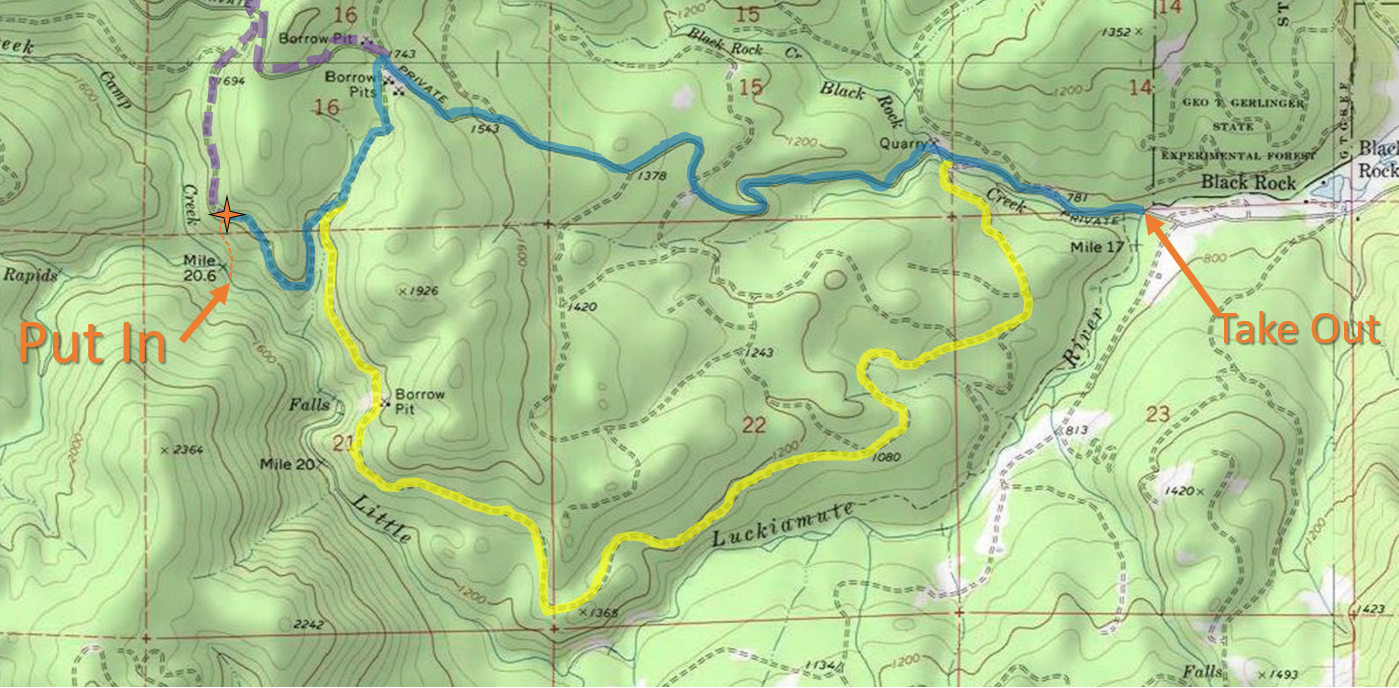
Access:   It is highly recommended you cache a map on your phone and bring it with you on the shuttle/hike since the road system is confusing and ever-changing.  At the very least bring a paper map.

Take Out: 44.869472, -123.510332

Put In parking: 44.869174, -123.556270

Driving into Falls City on Falls City Rd, you will pass the school and just as you reach the end of town stay right (left would take you over a bridge).  In 1/4 mile veer left onto Black Rock Rd, the road turns to gravel.  Follow Black Rock Rd 3.5 miles to a bridge and a white gate, passing by Camp Tapawingo and the world famous Black Rock Mt Biking area.  The bridge with the white gate is the take out.

**Whether the gate is open (on weekends during the hunting season) or closed (the rest of the time) dictates whether you are driving or hiking.**

                                 Photo taken during hunting season Oct 2016 at the take out bridge.


There are three main routes to get to the put in, they are delineated by color in the following map.


The Little Luckiamute travels from West to East
Click image to magnify


And some details from the put in area.

I like this route when hiking in through the clear cut.  Start down the dominant ridge, then cross left to the secondary ridge when reasonable and follow that to the stream.


BLUE (3.3 mi): This route is the most direct, but it's steep and high profile as most of it is on the Black Rock Mainline.  From the take out stay on Black Rock Mainline for 2.3 miles before making a left onto a small spur road, 0.4 miles later make a right onto a very small spur.  Half a mile later park and begin the hike down.


YELLOW (4.5 mi):  This route is the longest, but much less steep and lower profile so I prefer it for hiking and really it is best to drive this road to minimize visibility.  There is nothing illegal about kayaking back there, and keeping a low profile is a great way to keep it that way.  In February 2019 the bridge over Black Rock Creek was washed out, within 100 yards of leaving Black Rock Mainline, so it was not possible to drive this route.  Work is being done to restore the bridge.Cross the bridge at the take out and turn left in 1/2 mile.  Continue 3.6 miles and always choose the main/flattest/most straight option (don't go into the helicopter camp).


PURPLE (4 mi):  If you miss the spur road off Black Rock Mainline, you can catch the next left to get to the put in.

*It's also possible to take a route on the other side of the river using Valsetz Rd, then hiking Fanno Peak (gated) to a spur to a bush whack that people have taken when the gate was closed, but I'm not going to explain that route here.


----------------------------------------------------------------------------------------------------------------------------------------------
Original Write-up
----------------------------------------------------------------------------------------------------------------------------------------------

I had run this creek twice before, and hiked in a couple other times to scout.  After the first time I always knew I would return with the intention of running a beautiful 30' waterfall that was almost run blindly by Jeff Hartley on our first attempt of the creek.  That first time we were racing against darkness and had no time for a mishap or even to thoroughly scout the falls, sending us off into the woods for the portage.  The second time I returned, the water was low.  That second trip was about setting up ropes and scoping the run out for a return trip to run the falls with more flow and a softer landing.

On another trip Nate Pfeifer, Willy Dinsdale, and Brandon Bloomquist took me up on the idea to go back and check out the falls with the intent of running it.

We scouted the falls for awhile before Nate and Brandon decided to set safety for us, instead of running the falls which has a discouraging rock ten yards above the lip (gone in 2016).

I was concerned about the hit due to my tuck only making occasional appearances, but I really wanted to run the drop so decided to practice some mind over matter.  The lead in is a bit tricky so I was happy when my line went how I had envisioned.  I watched Willy have a great line as well only a few moments later making for a rewarding experience on the whole.

The team enjoys a special place!
(Photo Nate Pfeifer)


Nate Pfeifer did a write-up on the creek that can be viewed here.

2016 Update:  Catalyst and Osmosis are clean, the rock that was a nuisance just above the lip of Osmosis has rolled over and the alleyway leading into the falls is more straight forward as a result.

The following videos show the new configuration at Osmosis (0:50), and were taken at the best flow I have run the Little Luckiamute.
*Keep it muted at work or around the kids*
With Gusto from Difficult E on Vimeo.


This one also shows an alternate portage route at Tough Luck (3:00)


The wood situation was pretty good in 2019, just a couple easy portages in the class II-III stretch below the gorge.  The gorge was clean aside from Tough Luck.

Each year is different on this one as the levels get high, so wood cleans up or can land in bad places year to year.  I suppose that is all part of the adventure that is the Little Luckiamute.

     -Jacob


Monday, February 27, 2012

Rock Creek: Ryan Allen Rd to Columbia River (Money Drop)

This is the section with the famous Money Drop, an ever-changing drop near Stevenson Washingon in the Columbia River Gorge.

It's worth scouting the two big drops before putting on, this can be done via Iman Cemetery Rd.  Some routes have no tresspassing signs, but there are ways to get a good look.

Downstream of the put in bridge is 1/4 mile of warm up before the first falls.  This is a 30 footer that is run middle.  Below this first falls the river bends right as it goes over some more bedrock.  Get out on the left after the bend, and well before entering the low angle slide into Money Drop to get one last look from the left side.

Money Drop is a high speed, low angle ramp of 50 yards or so into a vertical drop of variable height.  You can typically count on it being over 50' tall.  It can be tricky to set the correct angle, resulting in many chaotic descents of the drop.  Recently (2016) the lip seems to have cleaned up and people no longer seem to have so much issue.

Andrew Bradley dealt with the tricky pre-2016 lip by boofing as big as possible.  While Andrew says his hit was soft, this technique is not recommended, at least one person has broken their back here.
Photo: Jeremy Lynn


Money drop from Andrew Bradley on Vimeo.


The level was about 10.10 feet on the Rock Creek gauge under the Ryan Allen Rd Bridge when Andrew and John ran it.
You can use the EF Lewis gauge to guestimate when Rock Creek will run. 
That gauge had a little under 2000 cfs when Andrew and John ran Money Drop.

Danimal rafted this one too.  Amazingly, he landed upright in the raft, unhurt. The level was pretty low that day, around 9.5'.

The falls was measured at 51' high the day he did it.
March 14, 2010


-------------------------------------------------------------------------------------------------------------------
STORY
-------------------------------------------------------------------------------------------------------------------


Andrew here, checking in after an exciting trip to Stephenson!

The first time I had looked at Money Drop I had been kayaking for about a year, I knew some day I would want to run big stuff and put this on the list. A few weeks back John Edwards and I had been to Money Drop and put in an all day scouting mission. We hiked in across from the drop and all around the lip trying to see different angles of the waterfall. Getting down to water level in this area is abnormally challenging due to the waste deep mud and failing hillsides associated with the active landslide. During this first scouting mission we had decided we wanted a safety boater in the pool to help pick up the pieces if one of us was hurt or out of our boat. We also checked possible put in areas and running the 30ft drop up stream. The flow that we had was around 1,100-1,200cfs.  The boil at the bottom was huge but manageable if you were up for the task; but at this flow the only way to get a safety boater in the pool was to have someone run the drop first.

       Jump forward to February 2012 when John Edwards, Jeremy Lynn and myself found ourselves here again at a lower flow in the range of 800-900cfs (just under half the EF Lewis gauge). We found this flow to still provide an ample boil.  This would be John's 7th time here and we now had a sufficient amount of people to safely run the drop.  The key piece of the puzzle for us was getting a safety boater in the pool below, which was pretty easy on this day.  Thanks Jeremy!  When we were there it had been raining and snowing with very little sunshine. We wondered around the drop scouting and talking about our possible lines and where we planed to hike our boats down for around 5 hours that day before running the drop. If you take a look at the photos most of the waterfall is not vertical at all, so boofing or over rotating are both very real possibilities.

Side view  
After looking at the risks I knew I needed a stroke but if it was too big I would be boofed out and with no stroke I would be kicked all crazy.  John went first with a plug line.  He over rotated a bit and became  unfolded near the bottom, taking a really big hit.  Fearing a similarly painful experience, I made sure I focused on staying locked to my deck.  I accelerated quickly towards the falls, the speed was exhilarating.
Very fast lead in
  As I approached the lip I focused on the transition for floating to freefall.  I took a full stroke that kept my bow way up.  After taking the stroke I knew I was boofing out.  I stayed forward in my tuck all the way to the bottom.  The thought came into my mind to stomp the bow back down, but I knew that has been the cause of broken backs in the past (including one on this very drop).  I fought this urge and remained forward until I reconnected, I was surprised when the landing proved to be really soft!  With my back still intact and another drop successfully descended I was super stoked! After it was all said and done John and I both had run it and had very different lines.  John was ejected from his boat, while I boofed and could not have landed much flatter. We both walked away safe and injury free, which is the number one goal on drops of this magnitude.   We both gained some more big drop knowledge to apply to our next endeavor, as well an experience that can never be taken away!  I fully anticipate coming back in the future to try and stick a different line off this drop.  Best of luck to those that attempt this tricky waterfall!

John's Line 
Boof!


video

-Andrew