Last summer, I got a call from a friend who works for OPB as a rigger (setting ropes to get cameras into remote places, along with the rest of the crew), saying that they were doing a story on kayaking the Salmon River Canyon. He said I should come along, and asked if I know a couple of the other guys that would be there, he thought their names were Luke and Ryan. I said "oh yeah, Luke Spencer and Ryan Scott?" Of course his response was affirmative, Luke and Ryan are essential figures in the Columbia River Gorge pedigree, with a combined tally of over 20 runs down the canyon.
I stated simply "I'm in."
In the weeks that followed, we firmed up the group, which would include Luke, Ryan, Keel Brightman (another SRG veteran), and Willie Illingsworth. We emailed schedules, checked weather and flows, tried to confirm a date, and finally pulled the trigger. The OPB crew spent the better part of a week getting the shots lined out and putting a good plan in place. All us kayakers had to do was show up and get it done, with about 8 go-pros that they lent us.
The result was fantastic! OPB did a great job with their shots and the edits and all the interviews. I was highlighted a little more than expected, mostly after I had the worst ass-kicking of my life. It was the first time I've ever been on the recieving end of a rope, and it's on five cameras. The OPB crew felt bad and super excited at the same time, cause the footage is great.
Without Further Delay:
http://www.opb.org/television/programs/ofg/segment/kayaking-waterfalls-no-way-out-but-down/
One thing that was overshadowed by my massive wipe-out was a general discussion amongst all of us, boaters and crew, about the spiritual aspect of kayaking. The episode touches on the subject, while not really delving in too deep.
For me, boating is the ultimate experience of nature, or at least one if them. Whether you're running the Salmon River Canyon or canoeing down the John Day, boating allows a person to commune with nature in a way that's quite rare in today's world. There's an element of meditation, of pure presence that comes with sports in the wilderness that really brings us closer to ourselves.
Again, in a short, it's hard to capture this element. I think the guys who put together "Why We Go" which detailed the late and great Curt Joyce's final river trip, did a damn good job of explaining the spiritual aspect that I'm talking about. Curt, you're so loved, and so damn missed!
Much respect for the guys who put this together, it must have been really hard. Such an expressive piece.
http://vimeo.com/91471066#at=0
Matt

Friday, April 25, 2014

Thursday, April 17, 2014
Product testing on Eagle Creek
Matt does some product testing on Punchbowl Falls last year. Skirt stayed on!
*He hiked back up and stomped the piss out of it.
Keep an eye out for our trip from this year where we endeavored to paddle a more complete section of the creek.
*He hiked back up and stomped the piss out of it.
Keep an eye out for our trip from this year where we endeavored to paddle a more complete section of the creek.
Thursday, April 10, 2014
Boulder Creek; Siletz drainage

BETA
Stream: While logging is an important and necessary industry in our state, I often wonder what Oregon's Coast Range might have looked like before Big Timber got ahold of it.
The Valsetz region of the Coast Range is one of the most heavily logged areas in Oregon, but there is one watershed in this area (Boulder Creek) that is still on public land and remains largely unmolested near creek level. Access is tough, and the run is challenging so not many boaters get in there. For those that do and have the capacity to appreciate the place for what it is, it is a special trip.
The ideal put in for Boulder Creek is at the confluence with Bridge Forty Creek, though access to that area is not available to most. A lower run starting near the confluence with Little Boulder Creek is the likely alternative. The run starts near Bridge Forty pretty small with some class III-IV and wood. Within the first mile the stream becomes a sheet of bedrock and turns to the right, at this point eddy out left to scout Boulder Creek Falls. This big falls has been run twice so far by Matt King and Ben Mckenzie. The lead in is intimidating and the right side lands on rock. The whole thing drops about 50' including the lead in. Aside from the intimidation it has a good line and landing zone.
Matt King is in there if you look close.

Below the falls things clean up a little, with many class IV(IV+) rapids and continued wood hazards. The further you get downstream, the better the rapids become and the less wood there is to deal with. The best section is downstream of the confluence with Little Boulder Creek.
Give yourself as much time as possible on this one, you are in a deep canyon for the second half and will be fighting daylight regardless of how smooth your run goes. Bring food, water and your sense of adventure.
Flows: You need at least 4,000 cfs in the Siletz for enjoyable levels, 6,000-7,000 cfs is a nice medium.
Access: The section from the confluence with Little Boulder Creek (44.933920, -123.670526) down to the confluence with the North Fork Siletz (44.920561, -123.696239) is going to be the only section of this creek accessible to most boaters. If you decide to do that run, I recommend continuing down the NF Siletz to this point: 44.892501, -123.716100 for an additional 3.5 miles of good fun on the NF.
If you want to check on current access, contact the BLM NW Oregon office and ask about access to The Valley of the Giants. You take the same route to Boulder as to the VOTG, crossing Boulder Creek less than 2 miles before you would get to the VOTG trailhead.
To get to the area, first cache the map onto your phone. Google does not acknowledge the road along the NF Siletz as existing, so you will need to read your map the old fashion way once you reach the turn headed north up the NF Siletz.
Take Valsetz Road out of Falls City, or if it's a weekend you can drive up the Siletz from Moonshine Park. Find your way along the logging roads to this turn, and head north: 44.878294, -123.708203 From this point Google Maps will not be useful. Continue on the road, passing by the optional take out down on the NF Siletz here: 44.892354, -123.716192.
Continue upstream 3-3.5 miles until you cross the bridge over Boulder Creek. Then, refer to the following map to access the lower section of Boulder Creek. This lower section is still available to boaters most any weekend, and if coming in from Falls City on weekdays too any time fire danger is not high.
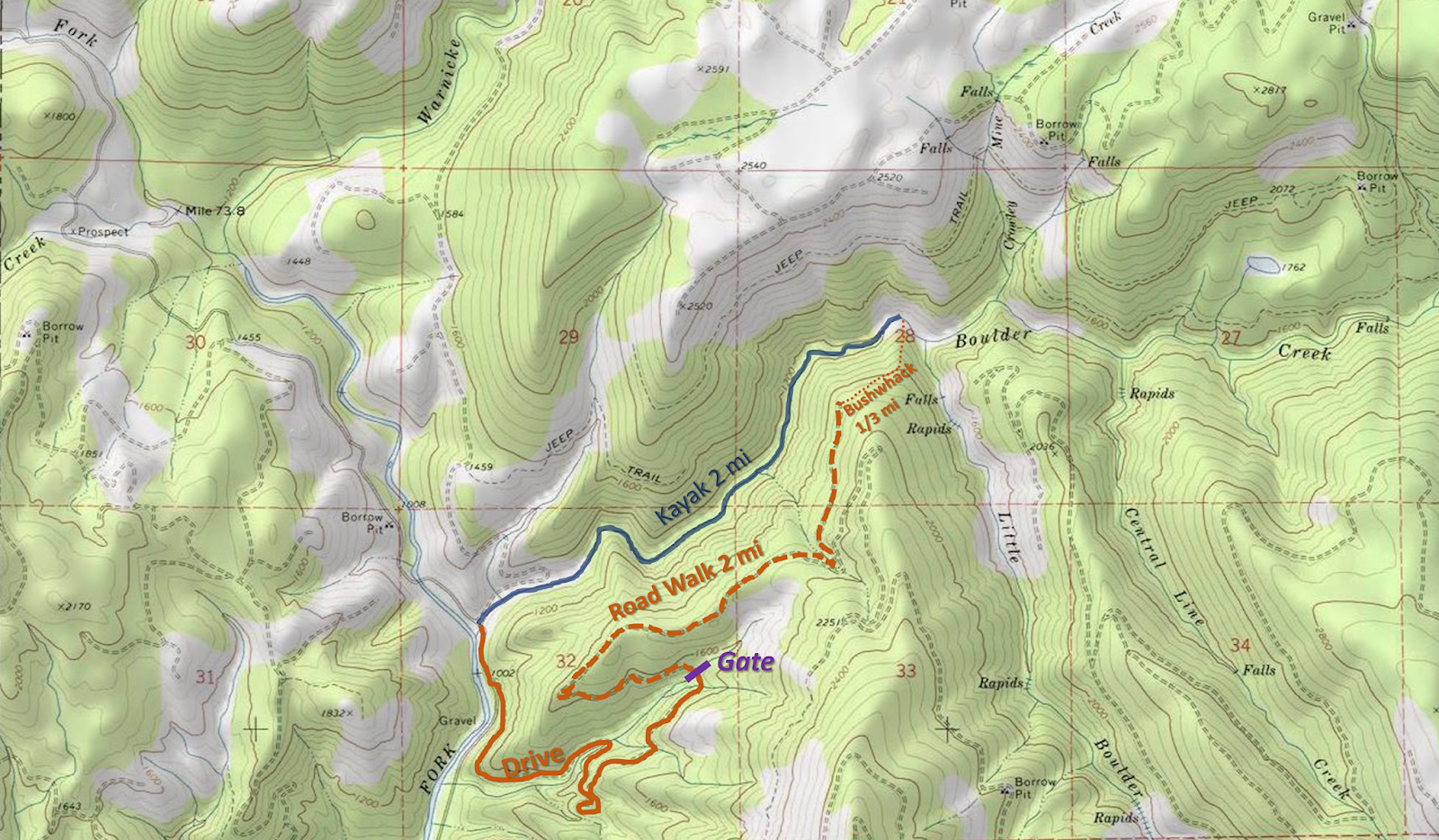
If you want to paddle all of boulder creek, putting in above the waterfall, continue reading.
"The Oregon Coast range is a mountainous version of the Bermuda Triangle. Gates appear, open, and close randomly. The famously incomprehensible road system is constantly evolving, so maps are only marginally useful. Even those who are experienced in land navigation can soon be hopelessly lost without a GPS. Tourists are regularly swallowed up by these mountains, and sometimes they don't survive the experience. Needless to say, for those who love adventure, this is a special place."
~Jason Rackley; Oregonkayaking.net
For the above reasons I won't be giving step by step shuttle directions. A summer scouting trip for access is recommended. If you try to figure out the shuttle for the first time the day you plan to run the creek, you will run out of light. Valsetz road to the Valley of the Giants has historically been open to the public on weekends when there is no fire danger, expect every other road in the area to be gated and closed except during hunting season. Though even that option may disappear in 2017. (2019: Valsetz Road is still open).
Put in: 44.93, -123.6292
Take out: 44.9206, -123.6962
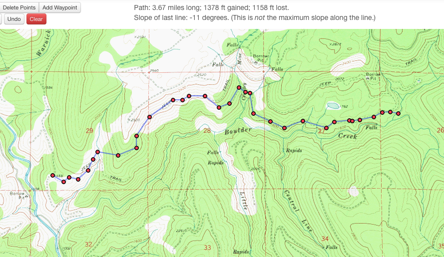
If you can't figure out the shuttle route, there is also the option to hike in from the take out along what the maps label as "jeep trails" along the north side of the creek. Below are two maps showing those trails.
Click on the map to enlarge it.

The hike is under 4 miles, and after the first mile looks pretty flat. I do not know the condition of the "jeep trails" other than that around the falls they are good for walking. I would not be surprised if in some areas they were overgrown.
----------------------------------------------------------------------------------------------------------------------------------------------
Trip Report
----------------------------------------------------------------------------------------------------------------------------------------------
----------------------------------------------------------------------------------------------------------------------------------------------
This was my second time down Boulder Creek in the Siletz drainage. It is an enjoyable but logistically challenging class IV-IV+ run with a tough 50' waterfall that can be portaged.
Paddling in the dark can be very enjoyable under the right circumstances, or it can be very dangerous under the wrong circumstances. This trip had a little of both.
The first time I did this run with Matt and Eric Harvey we needed to hike in 2 miles through the snow and had to charge on the river to get out before dark.
Photo: Matt King

Snow has a way of creating elegant situations.
Photo: Matt King

This time around everyone was once again pretty excited about running this rarely paddled stream. All nine of us in fact ( a large but doable number given everyone knew most of the others pretty well). The meeting time of 8:30 in Monmouth turned into not leaving Monmouth until after 10.
We were in good spirits on the long drive into the NF Siletz drainage.
We ran into another group of boaters doing what looked sure to be a fun run on the NF Siletz.
Shortly down the road we encountered a log across the road that we had beta would be there. Dan had the foresight to pack a manual chainsaw.
Time: 11:30 AM
We continued on and made quick time of leaving a car at the take out where Boulder Creek enters the NF Siletz. We embarked on the long shuttle drive (a little under 15 miles on arterial logging roads). We didn't need to resort to a map or GPS but having one in the trunk was a comfort.
During this period we encountered logs 2, 3, and 4 that required attention.
Time: 2:00 PM
First rapid, an interesting section of rock and water.
2:25 PM
It was not long before we arrived at Boulder Creek Falls. Many people quickly decided to portage this tough drop. In the end only Ben Mckenzie was interested in paddling the falls. He took the same line that I had seen Matt take 2 years earlier which was a right to middle move. Its a tricky lip with an even tricker and highly consequential lead in. Ben greased the line.
3:15 PM
It was after 3:30 by the time we were paddling away from the falls and tensions were already mounting. Below here the stream cleaned up significantly but the woody section from above the falls was still vivid in everyones minds. We moved slowly through this section and scouted often for wood.
At one point Ben was easing himself under a tree that came loose and landed on him, requiring assistance to hoist it off.
As tributaries came in we started running some quality whitewater and spirits rose a little even as fatigue started to set in.
We had a pin that took some heroic action by Joe to rectify. This pin put everyone back on their heals.
5:30 Finally Little Boulder came in on the left and I knew that we were in bad shape time wise with dark arriving at around 6pm, but the large group was finally getting into something resembling a rhythm. We started moving a little quicker and the added volume was welcome, making for some pushy rapids and some holes.
There was a quarter mile long section of pushy boulder gardens that proved to be the tipping point from holding on, to nearing loosing it as a group. I was chasing down an IK as I entered another rapid and chose to pass the craft instead of try to coral it. Sam along with Ben arrested it downstream in the first pool we had seen in some time as I headed upstream to check on the paddler.
As I headed that way I saw another boat floating downstream along with its captain. Ben and Sam once again collected our friend in the pool and the gear as I continued upstream. The IKer along with two other paddlers made the prudent choice to efficiently portage this rapid. By the time we were all moving again the light had changed as it was close to dark.
We were in what I remembered as the final gorge. We had two wood portages in here, at the top of the first portage it was already 6 o clock, the time we had hoped to be off the river by. We now knew every minute of light was more than we were counting on.
First gorge portage 6:10
After the second portage it was twilight.
Oddly enough, even after the obstacles we had faced and the lack of light, people pulled it together and for the first time we were really moving cohesively as a unit. I looked back to see everyone in our team spaced evenly and charging ahead as stoically as they could muster. Had we been moving at this pace and efficiency the whole time, light would never have been a problem.
As twilight faded we encountered the final boulder garden of the run. I knew if we scouted it we would be running it in the pitch black and saw a line through it so I kept paddling. The wood situation was worse at the bottom than I had been able to see from above or remembered and two people had close calls. This was the hardest decision of the day, but I still feel it was better to boat scout the rapid with the last minute of twilight than to run it/portage in the complete dark.
It took a couple minutes to get the group back together and some team encouragement was needed to get everyone back in their boats. People pulled themselves together for what I remembered as the last rapid (a slide into a hole). Alex and Ben gave good beta and everyone came through well.
A minute or two after that rapid I took this video.
A ways below here I had a conversation with the unrelentingly positive Sam Causey where he pointed out how now that the rapids were class II, the setting was nearly romantic. I knew what he meant and relaxed a bit on the 15 minute paddle from here to the take out letting the trip soak in.
Before long I started hearing cheers of joy as people saw the taillights of the take out car (Lucas had hiked back to the cars after breaking his paddle on the first rapid and was about to drive upstream looking for us.)
Everyone regrouped at the cars and the nerves and fear washed away instantly as relief began to set in.
The shuttle went smooth as could be hoped for in the torrential downpour, and everyone took turns recounting the days events.
While from the outside it is hard to see a trip like this as a successful one, those who have been in this situation know that you end up learning a lot about yourself and your friends and while you don't generally seek out that type of ending, there is still a lot to be enjoyed. On this trip everyone on the team had their roles and executed them when they needed to, Go Team!
I thought we had got away with one on this trip, little did I know Boulder Creek had left me a little surprise for later that week.
Daylight savings will be a welcome extra hour of light in the evening.
Flows the day we were there averaged in the mid 6k range on the Siletz.
Happy Adventuring,
-jacob
Tuesday, April 1, 2014
Nestucca River
This run has descended into obscurity in the recent past. It has a promising write up in the guidebook and flows when other Oregon streams are low. It could be that this lack of interest stems from the legal issues surrounding the kayakers who were arrested in 1991 for scouting a rapid on private property back when this stream used to be run on the regular. We checked out the stream this year and had a good day. The guidebook captures the stream pretty well, Iv'e typed that below. You can buy a copy of that book here.
The Nestucca River, classified as a State Scenic Waterway, drops relentlessly through a lush scenic forest into a small valley into which a few small farms are squeezed. Some stretches are quite uniform in gradient, others are pool drop. Much of the river can be seen from the road.
On this run, the river flows through about half national forest lands and about half private lands. The rights of property owners along the river became a major issue in 1991 when kayakers were arrested for trespassing while scouting the class V rapids. The issue is not yet resolved. Do not us private lands to scout or portage around the rapids.
At the put-in at Rocky Bend Campground, the gradient is nearly uniform. Shortly downstream is a class IV rapid. At 1.5 miles below Rocky Bend, after a curve to the right, is Silver Falls, where the river drops over and through a jumble of boulder (class V). At high water a class IV sneak is on the left. Immediately following is a class IV rapids in which the river flows around some boulders and over a shelf. A fast rock garden then leads to a log bridge that is an alternate put in. Enjoyable class II and III water continues for the remaining 6 miles to the take out on river right.
~Soggy Sneakers
Our take:
We found the guidebook description spot on. The stream is indeed a State Scenic Waterway, flowing though a forest. As stated there are a few quaint farms in the valley. We put in higher up than the guidebook run to get some extra miles. We were worried that what we could see of the stream from the road was mostly dull looking, I don't think any of the rapids are visible from the road and the sections viewable from the road passed by quickly. Though no doubt, there is a lot of flat water. There were a few sections that diverged from the norm, including a mini gorge section up top which had some class IV. If a paddler feels comfortable on Jordan Creek, they should be able to handle this run. A middle section offered some anthropogenic fish habitat that could be paddled over. Take a look if you are unsure what the best route through and over these are.
There is a campsite part way through the run accessible from the river if facilities are needed. There were a couple tributaries with fun slides in the 10 foot range on the upper section that can be walked up and ran.
Silver Falls was the rapid on our minds all day, resulting from our unsureness of the runnablility/scouting/portaging situation we would be faced with. As it turns out we were able to scout it from well below the high water line, avoiding confrontation with land owners. We took a left line and thought the section surrounding Silver Falls above and below had whorthwhile rapids. We had 1000 cfs on the gauge, and we were able to scout all the rapids from river level. This is as low as I would recommend running this section. I don't recall any portages, though there were probably one or two for wood. More water would be better.
Edit of the Nestucca River by Anna Herring and Priscilla Macy.
A lot of the tributaries and features in the area had bible themed monikers. We were throwing around a lot of "Church" and "Jah" jokes that day.
Bible Study from Jacob Cruser on Vimeo.
1,000 cfs on the Nestucca gauge provided minimal enjoyable flows.
Take out: 45.2788, -123.7071
Put in: I don't actually remember, but the fun mini gorges were above the put in used in Soggy Sneakers.
The Nestucca River, classified as a State Scenic Waterway, drops relentlessly through a lush scenic forest into a small valley into which a few small farms are squeezed. Some stretches are quite uniform in gradient, others are pool drop. Much of the river can be seen from the road.
On this run, the river flows through about half national forest lands and about half private lands. The rights of property owners along the river became a major issue in 1991 when kayakers were arrested for trespassing while scouting the class V rapids. The issue is not yet resolved. Do not us private lands to scout or portage around the rapids.
At the put-in at Rocky Bend Campground, the gradient is nearly uniform. Shortly downstream is a class IV rapid. At 1.5 miles below Rocky Bend, after a curve to the right, is Silver Falls, where the river drops over and through a jumble of boulder (class V). At high water a class IV sneak is on the left. Immediately following is a class IV rapids in which the river flows around some boulders and over a shelf. A fast rock garden then leads to a log bridge that is an alternate put in. Enjoyable class II and III water continues for the remaining 6 miles to the take out on river right.
~Soggy Sneakers
Our take:
We found the guidebook description spot on. The stream is indeed a State Scenic Waterway, flowing though a forest. As stated there are a few quaint farms in the valley. We put in higher up than the guidebook run to get some extra miles. We were worried that what we could see of the stream from the road was mostly dull looking, I don't think any of the rapids are visible from the road and the sections viewable from the road passed by quickly. Though no doubt, there is a lot of flat water. There were a few sections that diverged from the norm, including a mini gorge section up top which had some class IV. If a paddler feels comfortable on Jordan Creek, they should be able to handle this run. A middle section offered some anthropogenic fish habitat that could be paddled over. Take a look if you are unsure what the best route through and over these are.
There is a campsite part way through the run accessible from the river if facilities are needed. There were a couple tributaries with fun slides in the 10 foot range on the upper section that can be walked up and ran.
Silver Falls was the rapid on our minds all day, resulting from our unsureness of the runnablility/scouting/portaging situation we would be faced with. As it turns out we were able to scout it from well below the high water line, avoiding confrontation with land owners. We took a left line and thought the section surrounding Silver Falls above and below had whorthwhile rapids. We had 1000 cfs on the gauge, and we were able to scout all the rapids from river level. This is as low as I would recommend running this section. I don't recall any portages, though there were probably one or two for wood. More water would be better.
Edit of the Nestucca River by Anna Herring and Priscilla Macy.
A lot of the tributaries and features in the area had bible themed monikers. We were throwing around a lot of "Church" and "Jah" jokes that day.
Bible Study from Jacob Cruser on Vimeo.
1,000 cfs on the Nestucca gauge provided minimal enjoyable flows.
Take out: 45.2788, -123.7071
Put in: I don't actually remember, but the fun mini gorges were above the put in used in Soggy Sneakers.
Thursday, March 27, 2014
Diatoms
That’s where Adventurers and Scientists forConservation (ASC) comes in. ASC is a really cool program that teams up outdoor sports enthusiasts with researchers, allowing scientists to solicit sample collection from very remote areas. I signed up the CCC to be a part of ASC, and they teamed us up with Dr. Loren Bahls, who studies diatoms. Diatoms are unicellular aquatic microbes with cellwalls make of glass- silicon dioxide. Diatoms are ubiquitous in pretty much all water environments, and make up the main bulk of the base of the food pyramid: they are estimated to account for 40% of all plant production worldwide, and as photosynthesizers they play a significant role in the global carbon cycle. Diatoms are good water quality indicators and identifying diatoms in various waters tells us a lot about that specific habitat. Currently, it’s estimated that only 12% of the global diatom species have been named and described; of the diatoms identified in the US, most have been found in lower elevation, polluted waters. So, armed with sampling bags and paddles, the CCC headed off to Washington to try to find some new diatom species in some pristine NW kayaking runs.
First up, we headed to the Upper Upper Cispus. After getting warmed up on the put-in waterfall, we took our first sample just below the Adam’s Creek confluence.
 |
| Sampling Crew (photo by Joe Kemper) |
After that we pretty much concentrated on kayaking. Lucas Glick and Michael both had great lines on Island (I had a great line on the portage around island), and at one point I was laughing out loud after landing a massive boof on one of the bigger boulder garden rapids.
 |
| Lucas Reitman blasting through the hole at the bottom of the gorge of no return |
But, before we knew it, we were at the lip of Behemoth. Behemoth is definitely one of the most intimidating waterfalls I’ve run, but there’s not really another option (technically the portage is possible, but even experienced and frequent portagers like myself find it intimidating). In the end we all had good lines off the monster, although some were more stylish than others. And, while I was waiting for the boys to make it down, I took some more Diatom samples!!
 |
| Diatom Sample, shown with Behemoth for scale |
 |
| Joe, showing off his EG lean |
The final boulder gardens were delightful. And near the end of the run, we hiked up a side canyon and found an extra bonus waterfall (and some more diatoms)!
 |
| Michael and I hunting diatoms |
 |
| Myself, being very excited about diatom collection (photo by Lucas Rietmann) |
 |
| Jacob nailing a sweeet sampling line |
 |
| Chillin' in the cave, catching diatoms |
Collecting samples on these kayaking runs introduced me to a new perspective. Especially in the flat water stretches, I spent more time searching the gorge walls for seeps, side-streams, and small waterfalls coming into the river. I’ve always appreciated the scenery that I get to see when I’m down in these remote gorges and canyons, but focusing on these things made me realize how much I miss when I’m just concentrating on the whitewater. I’m definitely looking forward to continuing to do some sampling, especially on some of these exploratory creeks that Jacob has lined up…
I highly recommend that any adventure-type folks check out ASC, they have projects all over the world that are looking for people to do very simple sampling or keeping records of wildlife that they see.
And now back to your regularly scheduled kayaking with a video of the UUCispus by Lucas Rietmann:
Upper Upper Cispus from Lucas Rietmann on Vimeo.
~Anna Herring
Sunday, March 9, 2014
Tamolitch

Paddler: Scott Baker Photo: Lucas Rietmann
April 11, 2018 @ 1,100 cfs
April 11, 2018 @ 1,100 cfs
Tamolitch is an interesting waterfall along the Mckenzie River. The river flows through lava fields of vesicular basalt, which creates a very permeable and porous ground. When the aquifers below are not filled with water, the entire flow of the river runs underground leaving the surface completely dry. There was a time when the aquifers below the surface filled each Spring, allowing the river to flow for weeks at a time, but those days are gone.
There is now a dam upstream, holding back Carmen Reservoir. Water is not released from this reservoir at a consistent enough rate to keep those underground aquifers full. Thus, even when there is a big rainstorm on top of a full pool height of the reservoir it can still take three full days of high flows to fill the aquifers before the river is able to flow above ground all the way down to and over Tamolitch Falls. Most of the time the entire river bubbles up from the ground into the pool at the base of the bone-dry falls, before emerging and continuing downstream as a conventional above-ground river again.
Because it is so rare for this waterfall to flow, and even more rare for it to flow at levels suitable to kayak over, it does not get paddled often. In fact, while rumors existed of someone paddling it "back in the day" when Eugene was considered the place to be for professional kayakers, no one I knew of could say who it was or had seen any photos or anything. I found that intriguing so set about sorting out when the falls might run.
I certainly wasn't the only person interested in this waterfall, some had even tried to go to the falls when flows elsewhere were high only to be skunked by a dry falls. By 2013-2014 I thought I had sorted out a way of making an educated guess as to when the falls might run. In 2014, such a day came and while I needed to work (and waterfalls aren't really my thing anyway) Priscilla got a group together to check out the drop. That story is told from her perspective further down this page.
Nowadays, the information is there for those who want to drop this beautiful and rare 50' treat. Even if you don't have any intention of running the falls, it's a remarkable place for anyone to check out. Whether it's dry or flowing, it's a must-see for any Oregonian. Just be aware it's one of those place that has become overrun in the social-media age. There might be 100 people walrusing at the falls on any given Summer weekend. On the other hand, after three days of rain you might just have the place to yourself.
April 12, 2018 @ 1,150 cfs

Paddler: Ben Mckenzie Photo: Priscilla Macy
Once you are done at the falls, you can paddle and hike the trail back down to the trailhead. Some people will choose to just hike the trail the whole way. For those that want to try and paddle some, there is a class IV section not far downstream of the falls with plenty of wood hazards, before it tapers to class II-III. Eventually it becomes so woody that paddling isn't very justifiable. Fortunately the trail is close to the river (river-right) the whole way, so it's reasonable to bail off the river at any point that the right wall is not prohibitive.
Flow Information: According to the USDA, the falls typically starts spilling when the Clear Lake Outlet Gauge has been flowing over 900 cfs for three days in a row. That is for predictory use only.
Use the following gauge to determine if the falls is currently in, people typically shoot for at least 1,000 cfs.
USGS 14158740 MCKENZIE RIVER BL PAYNE CR, NR BELKNAP SPRINGS, OR
It takes very large, sustained storms to bring this falls in. Check the gauge when everything else is flooded, or when they are doing maintenance on Carmen Reservoir dam upstream.
Access: Tamolitch Falls is a waterfall on the Mckenzie River, a little over an hour East of Eugene. To get there take Hwy 126 to the turn off for "Blue Pool" onto NF-730 and follow that to the Blue Pool trailhead, which is the take out. The NF-730/Hwy 126 junction is about 13.5 miles NE of the bridge over the Mckenzie within the town of Mckenzie Bridge, and 5.5 miles south of the Sahalie Falls turnout.
To get to the falls from the Blue Pool trailhead:
Option 1 is to hike upstream 2 miles on the trail to Tamolitch/Blue Pool.
Option 2 is to return to Hwy 126 and head upstream 2.3 miles to a spur road heading towards the river. If you go that route, have imagery downloaded on your phone so you don't get lost. At the end of the 1 mile road, a steep trail leads down to the falls. This road is often gated.
Option 3 if the gate is closed to the spur road involves either hiking the road, or bushwhacking down from just passed the gate to the river and across to the Mckenzie River trail and following it half a mile downstream to the falls (I don't recommend boating the river down to the falls).
----------------------------------------------------------------------------------------------------
Resurrecting Tamolitch, by Priscilla Macy
Tamolitch Falls, also known as Blue Pool is a unique waterfall on the McKenzie River. This area is where the McKenzie River comes back up after being underground just after Carmen Reservoir. It's known as a dry falls, only coming into existence after long periods of rain when the river will flood over the lava bed.

Tamolitch from Below. You can see some of the water coming from under the lava beds on the right.
We could not confirm or deny if anyone had run the falls yet, due to the rarity that it comes in at a runnable flow.

There was not a huge boil with the minimum flow, so there were a couple hard hits. All around, good lines and an excellent time at a beautiful and unique spot.


Dalton's Turn

Lucas' line
If you have time after the falls, the McKenzie has some great play waves with eddy service when flows are high.

-Priscilla
A group returned a few days later with more water and felt the falls cleaned up nicely with the additional flow.
Tamolitch Falls - A Church Story from williamsaunders17@gmail.com on Vimeo.
Subscribe to:
Posts (Atom)