Stream: A short section of bedrock not far off Hwy 22 that flows into the North Santiam near the town of Marion Forks. It's a novelty run at best, but was worth doing for us under the right occasion. We thought if we were driving from Salem to Bend at the right time of year it could be a nice way to break up the drive. Or if someone was looking for a class IV version of Sweet Creek.
There is a short walk in through the woods, and everything can be scouted either by the standard method of catching eddies and walking down the bank, or before putting on by walking down a rudimentary use trail that parallels the creek on river right.
There was one log that was in the way when we did the run in 2019 that required us to bang down a shallow channel on the left. The rest of the run was clean.
The last horizon is the tallest, and is run down the middle. Below this ledge/ramp the creek returns to boulders and the take out is on the right just below the island in the following photo.
Flows: We were checking this creek out on July 5, 2019. It had some water left due to snow-melt, but it wasn't really "in". Enough for a fun adventure for us, not enough to recommend to others.
These photos were taken from the bridge just downstream of the take out.
The rock circled in the photo was wet, with water washing over it. If it was covered, I think that would be a runnable flow.
Access: No need for a shuttle vehicle. Drive to the town of Marion Forks, about 16 miles SE on Hwy 22 from Detroit (between Salem and Bend). Head up Marion Creek Rd 3 miles, there will be a bridge off to the right. 100 feet past this an easy-to-miss road goes to the right into a campground, which is the take out. Scope out/mark the exit from the creek at this point. To get to the put in drive upstream 1/4 mile, on a short straight away after a right turn and before a left turn park in a tiny pull out to the left. Walk up the road another 100 feet and enter the woods and b-line for the creek.
The walking is easy, there is a final bench to drop down to the creek. If you are in the right spot there will be a log jam above and the first horizon below.
If you want, you can set the boats down before the bench and walk upstream a short distance to take in Gooch Falls. It's not runnable, but is pretty. There is a rudimentary trail that goes down to the campsight from Gooch Falls along the creek, so you can scout everything before putting on if you like.
It was the first weekend in July and we had done two week long trips to California in June. I didn't really want to spend much time in a car this weekend, but still wanted to see something new. It had been a good snow year so I thought there might be some water flowing off the Cascades still, so I set about finding a creek that would be capturing that snow melt I had not paddled yet.
I had seen plenty of photos of Marion Creek in the summer-time and it seemed like it held it's water better than rain fed streams of similar size. I had read the Oregonkayaking trip report and while I didn't want to repeat that experience Jason had mentioned in there a section of ledges and slides below Gooch Falls. The maps did show some waterfalls, and there was a bridge downstream that would make for a take out to a half mile section.
Priscilla and I headed up on a Friday with our rock boats, and found the logistics pretty straight forward. We hiked in to Gooch Falls via a short bushwhack. Gouch Falls was worth staring at for a bit before we headed downstream. 50 yards of boulders led to a log jam portage, and just downstream was a horizon line. I recognized this first drop from the OK trip report. We ended up taking a center line instead of the left line.
We found the section below to be just as advertised, 1/4 mile of small ledges and slides. We scouted a number of them, one had a log in the main line that we skirted to the left of. Other than that it was a clean creek bed.
Just below the largest ramp/ledge the creek returned to boulders and I saw a log jam downstream of the next island. I headed over to the right bank to portage and noticed it was at a campsite. I set my boat down and looked around the corner to see the take out bridge, so instead of portaging just left the boats at the campsite and I jogged back up to the car while Priscilla explored a trail heading upstream from the campground.
We decided that we should do another lap, so drove up to a point Priscilla had determined from her trip up the trail from the campsite would drop us in just below the log jam we had portaged at the top on our first lap. This time we didn't have to get out of our boats and were smiling as we hopped out again at the take out.
We both thought we might be back some day to break up a drive between Bend and Salem, feeling it was like a tamer Sweet Creek experience. With more water, maybe we would even leave the rock boats at home.
We still had some time left over so paddled the Breitenbush at the lowest flow I have done yet. We didn't have to get out of our boats and I'd probably even do it again at that flow under the right circumstance. The left side of Sharon's closed out and pinned Priscilla, and we took the second from the left slot at the Notch, everything else went in the normal lines. We took out just upstream of Humbug Creek, as we typically do if flows are low.
The Little North Santiam @ Mehama gauge is far downstream of the "Opal runs" that kayakers from the area like so much. It's a useful gauge, but there is often discrepancy between gauge readings and actual flow. For example, last Sunday it was reading 680 cfs and dropping when I left my house in the morning. The low water cut off is generally considered to be 700 cfs. We ended up having a pretty medium flow, one I would have generally associated with 900-1,000 cfs on the gauge.
The day before the gauge was 1,600 cfs and dropping when I left my house and the stream felt like what I would normally associate with that flow.
A few years ago I noticed a gauge much closer to the "Opal runs", right at the take out for Opal Gorge in fact. There is no online reading, but Mick Evans has set up a Facebook page to report that flow on. If that reading interests you, following that page will give you updates. I am also collecting data here and will pull from that Facebook page.
The Elkhorn gauge, at the Elkhorn bridge.
44.8358, -122.355
------------------------
In the meantime, the first big rain of the season is always an exciting time for boaters. In Oregon, Opal Creek is one of the most highly sought after rain fed runs and people flock to it early in the season.
Here is a video from Nick of opening weekend 2016, where we did a mine to Salmon Falls run at 6' on the Elkhorn gauge (I consider 5' to be the minimum flow). 6' is a nice flow for Opal Gorge where the run is not any harder but the lines open up in the main drops and the in between rapids are more fun than usual. If it gets much higher The Undertaker needs to be portaged on the right. On the main run nothing is harder (Big Ugly is even easier) except for Big Fluffy, which handed out some swims and a low percentage of upright lines.
Stream: This is a short but sweet stream near Detroit. Nearly all the notable rapids have some bedrock component with an unusual amount (for Oregon) of scoured down bedrock slides and ledges. Wood is present, but if you pick the right routes there are no portages (as of Spring 2016, and still clean in Winter 2019). I usually do a couple laps when I'm up there, going slow and scouting the first time, saw in hand, then taking a second lap straight through.
Typical Boulder Creek
After a short 1/4 mile hike along a game trail and a short off-trail descent to the creek (easy to follow in 2019) the trip begins immediately with a section of fun bedrock rapids. It's probably best to shore scout anything blind rather than read and run your first time down if no one knows the run.
After the initial barrage of bedrock there is a short manky section before things return to bedrock. Enjoy these fun slides but tread cautiously as about halfway down and around a blind right turn lies the largest rapid, The Venue. You need to scout before turning the corner or run center moving right at this short horizon line. Scouting/portaging/lapping is all convenient on river right.
The Venue
Photo: Nick Hymel
*There is another corner above this one that seems like it could be the lead in to "The Venue", but isn't.
There are only a couple of small rapids between The Venue and Hallpass. The line at Hallpass is to enter right-ish and run the ledge/hole at the bottom center, keeping your nose up. The move is not too challenging but that hole is backed up and should be taken seriously even though it's not a visually impressive rapid. Safety is tricky but can be set.
Hallpass
Below here are more fun rapids, of all sorts. It can be a bit blind and fast paced, but when wood free is all good fun.
The bedrock ends abruptly just upstream of an island with a large log blocking the right channel.
From here, you have a couple options.
Option 1: You can continue working your way downstream. There is some wood to be dealt with, and the class III whitewater is all bouldery. If you are going for this route, my recommendation is to scout out the situation while running shuttle by walking upstream from the bridge on the overgrown road to scope out the Trash Collector, this small but problematic area will be obvious when you see it, a short distance upstream of the abandoned silo.
Option 2: Take out before the island with the log. There is a walk-able road on river right that leads to Hwy 22 near the bridge.
Option 3: Regardless of whether you took option 1 or 2, you can continue down to the North Santiam. Just be sure to look around the corner from the bridge over Boulder Creek before you paddle around that corner.
Once on the North Santiam it's a splashy class III big water ride down to the next bridge.
Flows: Our reconnaissance trips were done with the Blowout Creek gauge (The most relevant I believe) at just over 200 cfs, North Santiam blw Boulder Creek between 1500-2000 cfs, and the Brietenbush Gauge around 1,000 cfs. That was a safe level for exploring Boulder Creek's blind corners and long slides with small eddies, but was hard on boats and that's not a flow I go back for.
Iv'e been back at 350 on the Blowout Creek gauge when it rained the night before and had good flows.
Iv'e also run the creek at 700 and dropping when it hadn't rained the entire previous day and it was in but lower than the day at 350.
The best flow was 600 after a night of rain, and you could go higher.
It just speaks to the fact that the ballpark gauge is just that, a ballpark. If you aim for 500 cfs in Blowout, give or take a couple hundred after a night of rain your chances for enjoyable flows are good.
The good news is you can get a visual check before putting on. For our 2016 trips, water was just barely spilling into the trough on creek left under the Hwy 22 bridge. For a good medium flow, water was spilling over the rectangular support indicated below. The riverbed is comprised of boulders here, so don't be surprised if the streamed changes and this reference becomes obsolete.
*The creek will look low from the bridge, but if it looks like you can float your boat down here the creek should be at a good level.
Below is a visual guide to the visual gauge.
Exploratory flow: No water over rectangular support, but water is splashing into the trough. March 6, 2016 Blowout Creek Gauge: 220 cfs
A fun, low level: Water pulsing over the rectangular support.
Medium: Water spilling consistently over rectangular support. March 11, 2017 Blowout Creek Gauge: 600 cfs
The Gist:
If there is water on the rectangular support, there is enough water for the creek to be fun.
High flows are undetermined.
If water is not getting onto the rectangular support, you may still be able to run the creek if water is getting into the trough, but it will be scrapey.
After 5 trips to this creek, it's probably my favorite backyard style run in Oregon.
Access: Take highway 22 east out of Salem up to the town of Detroit. Within 5 minutes of passing Detroit you will cross the bridge over Boulder Creek (signed) near the town of Idanha. This serves as a place to leave a take out vehicle, check the water level, and scope out the Trash Collector. If you want to continue down the North Santiam, turn right onto Blowout Creek Rd and follow it to a bridge 2 miles after passing Detroit.
Photo pulled from google maps street view
To get to the put in return 0.3 miles toward the town of Detroit on highway 22 from the Boulder Creek bridge and turn right onto Boulder Ridge Rd/NF-2231. Travel 1.3 miles up this paved road to where it makes a sharp 180 degree turn to the left. Park near a yellow road sign before the turn and locate an overgrown road going off to the right, at the start of the 180 degree turn (50 yards past the sign). The trail was well marked in 2019 and easy to follow.
If you are reading this in the future and the trail is no longer in good shape, here is the general path: Walk the short distance along the overgrown road and follow the path of least resistance as it drops down from the road grade, then heads upstream quickly reaching an old game or logging trail at the far end of a scree slope. After about 1/6 mile on this trail, it splits at a small ridge. Take the steeper left trail over this ridge. For the most part the path has up to this point been close to flat, but about 100 yards after the ridge the trail gets steep, then very steep, at this point* veer off the trail to the right and follow the path of least resistance upstream (more or less maintaining elevation) over to another small ridge that is followed down to the creek. In 2019 the trail was all easy to follow.
*Where to leave the trail, from here cross-hill to the next nose of land and follow that down.
It took three trips, but we finally got the logistics figured out for this run. My first trip up there I didn't expect the creek to have any water and was just going to scout, but John Harmon sent me a couple photos from the take out bridge after he got off the nearby Bruno Mountain run on the North Santiam the day before. Looking at those photos I thought that maybe it might just barely be runnable so brought my rock boat just in case and planned on meeting Steve Tegtmeyer to run the Breitenbush if the new creek wasn't runnable. I scouted around a bit and saw a couple fun looking sections so when Steve Tegtmeyer showed up, we talked it over and we decided to give it a go. He and I had a nice trip, but flows were at exploratory levels and we put in below some of the good stuff. We had a couple portages near the end, so i decided to take out a little earlier the next time.
The second time there was a much larger group consisting of Ross George, Brandon Lake, Nick Hymel, Pete Giordano, Ben Mckenzie, Jesse Shapiro and myself. That time we decided to put in as high as we could float a boat in order to suss out the entire stream. We did that, with the upper section leap frogging between fun bedrock rapids and wood portages. It was a trying day, and the fatigue eventually caught up to us in the form of a dislocated shoulder in Hallpass. The information we gleaned from this trip provided the knowledge needed to get logistics dialed for return trips to this unique run.
Hiking in on the information gleaning mission.
I made a mistake about which spur road to hike in on despite having the correct information relayed to me. This meant we carried our boats further than necessary, dropping in on a tributary, meaning we began our trip with a couple extra portages.
There was some fun stuff in the upper reaches, but there were about as many portages as good rapids.
If this looks like fun, the upper section might just be your cup of tea.
photo: Nick Hymel
Eventually we made our final portage and had over a mile of fun bedrock rapids, some of which are visible on google imagery, which is what got me excited about the creek in the first place.
Halfway down the lower stretch we arrived at The Venue. Here there is a nice platform on the right where you can watch the show, from which you can then decide if you want to be a part of the show.
Nick Hymel, center-stage
*TheVenue comes around a blind right corner that looks like the rest of the creek. If you turn the corner, you will be running the drop blind. Look for a couple small eddies on the right just before the turn with green flagging and a root wad on shore.
A short distance below The Venue lies Hallpass, where fatigue combined with a rocky lead-in to a backed up hole led to a swim and dislocated shoulder on our reconnaissance mission. Impressively the boater with the dislocated shoulder, who is no stranger to pain, paddled the rest of the run after popping the shoulder back in himself.
Hallpass
Downstream were a few more fun rapids before the take out we have been using. It is at the end of a long bedrock sliding rapid that splits at an island where the right channel has more water and ends in a ledge (there are a number of spots on the run that fit this description). Just below here the creek bends right with a couple eddies on the left along a wall. From one of these eddies ferry over to river right where there is a convenient take out. Downstream of here is a small log spanning the creek as the stream transitions to boulders for the duration of its course. From the take out eddy you can walk downstream and away from the creek to a flat area which can be followed a short ways downstream to the take out. Or you can paddle/portage the final 100 yards of the creek to the bridge.
Nick took some helmet cam footage during the reconnaissance mission that I put together.
For round three, I was able to locate an ideal put in that provides the most bang for your buck; with no portages and many bedrock slides and rapids including both of the named rapids. If you are looking for a longer day, you can walk from the take out described above on creek right down to the North Santiam River and get about a mile of splashy class III down to the Blowout Creek Rd bridge. There is a nice wave just above the bridge on river left that is fun to surf at the levels required to run Boulder Creek. The turn off to this bridge is about 1 mile back towards Detroit from the highway 22 bridge over Boulder Creek.
Trip two (photos from this report) was on March 6th, 2016
I think the Blowout Creek gauge will reflect flows the best in Boulder Creek.
I would recommend a slow first lap to figure things out, then a second, faster lap. Or combine this run with Sardine Creek, French, Brietenbush, Secret Stash, Cedar, Bruno Mt, Opal stuff, etc.
2 miles, IV(V) with the option to put in higher for some V-V+
Stream: Cedar Creek used to have a notorious reputation as a fringe run, only for those looking to hairball down some class V+ with tiny eddies. While you can pick off some large drops above the put in, there is also a roadside 2 mile section of nice class IV(V) that is verging on must-do for Willamette Valley boaters.
Photo: Priscilla Macy
While Cedar Creek can be run on it's own, it combines well with a run on Classic Opal since it is easy to use the same take out at Three Pools. From there it's just a short drive upstream to the bridge over the Little North Santiam at the Cedar Creek confluence. Boaters can scope out the wood situation as they drive along Cedar Creek, there are usually a couple logs and some brush that need dodging.
For how roadside it is, there are some beautiful spots on Cedar Creek.
Photo: Priscilla Macy
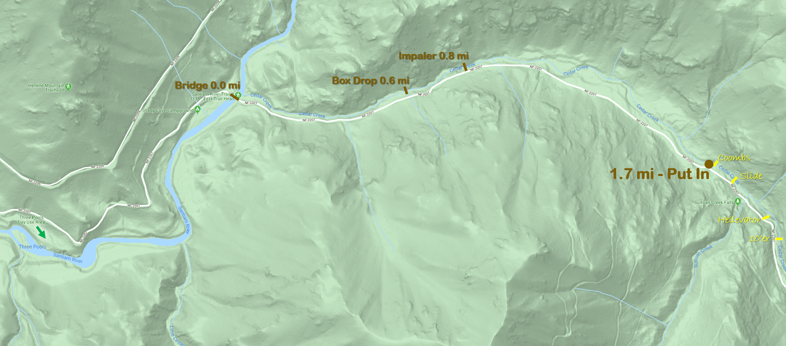
Less than 1/4 mile upstream of the bridge is the campground ledge, where flows are checked. Flow information is further on down this page. 1.7 miles after crossing the bridge at the LNF/Cedar confluence is the put in at a small pull out on the left. If you make it to Sullivan Creek (a tributary with a big waterfall right next to the road), you have gone too far. The put in is right at the base of Coombs (which you can glimpse from the road). While most boaters will put in at the base of Coombs,
boaters interested in V-V+ whitewater can check out the 1/4 mile
upstream. It's all roadside and the big drops are easy to scout. If
you are planning to run those drops, the whole section should be
thoroughly vetted before tackling. The eddy situation is sparse and the
drops complex.
Hellevator, one of the big ones above the put in on Cedar Creek.
Most people will skip the big stuff and put in at the base of Coombs.
Things start off with a short section of engaging whitewater. After the first few rapids, things ease off for a bit and there is some mellow class II-III with a manageable amount of wood and brush to maneuver around.
One of the first fun rapids.
Things pick back up at Impaler, which comes just after passing a campground with a fence visible from the creek on river left. Downstream the creek enters a straight away with a horizon falling back to the right at the end. The eddy to scout/portage is on the left half way between the horizon and the sign in the photo below.
Impaler is a two ledge rapid, the first is ugly and the second is good so most people choose to seal launch straight into the lip of the second ledge. The second ledge can also be portaged with a seal launch a bit further down.
A few more good class IV rapids separate Impaler from Box Drop, the second and final class V rapid. Box Drop was also marked by a yellow sign in the trees on the left in 2020, just below a fun rapid with some offset hydraulics ending with what qualifies as a pool on Cedar Creek.
Box Drop has been run both right and left, but also has an easy portage on the left.
Ben does it right.
Some more read and run leads into the campground/gauge ledge, which is run center.
Then it's non-descript but steep whitewater all the way to the confluence, on both my runs we have hopped out once to scout down here. Once on the Little North Santiam it's about 1 mile of boogie down to Thor's, which can be scouted along a trail on the right if flows are higher than you typically run Opal.
In 2020 there was plenty of wood and brush to be maneuvered around on Cedar Creek, but no wood portaging.
Thorough scouting from the road beforehand makes the trip run smoother, as it's less likely stuff will sneak up on you. While Impaler and Box Drop were signed in 2020, if you want to visually inspect the eddies before putting on you can do so 0.6 and 0.8 miles above the bridge at the LFN/Cedar confluence.
Flows: Use the Little North Santiam @ Mehama gauge to ballpark flows, keeping in mind it can make a big difference if flows are rising vs. falling. We were there two days in a row to start off 2020 and the first day flows were higher than I would run the creek, with big holes and few eddies. The second day flows were what I would call a perfect medium. Graph below.
Once at Cedar Creek, you can get a visual at the campground ledge, about 1/4 mile upstream of the Cedar/LNF Santiam confluence.
There are two rocks on the lip of the ledge that can be used to assess flows. The one circled in blue needs to be covered for the creek to be worth paddling. Perfect flows have just a tiny bit of water spilling up and over the rock circled in orange. If there is enough water that you could potentially paddle over the orange rock, flows are high. I personally would never paddle this creek high, as stopping would be a real challenge due to sparse eddies, it would be a high speed class V descent with wood in play.
Water over blue rock = enough water Orange rock boofable = high water
High
Perfect Medium.
Friendly and fun.
Access: Take I5 to Salem and head East on Highway 22 towards Detroit Reservoir. In about 22 miles turn left at a flashing yellow light onto N Fork Rd. In about 15 miles the road turns to gravel, just under 2 miles after that turn right (there is a kiosk and some boulders at this location). Just under a mile after turning right at the kiosks, pull right into the paved Three Pools Day use area (not signed). Three Pools is the take out: 44.840457, -122.313914 Coming out of the Three Pools parking lot, turn right. In about 1 mile you cross a bridge at the confluence of the Little North Santiam and Cedar Creek. In another 1.7 miles is the small pull out on the left adjacent to Coombs, this is the put in. If you are looking at the creek from the road you should be able to catch a glimpse of Coombs through the trees. If you get to Sullivan Creek, you have gone too far. If you are interested in the 1/4 mile of V-V+ above the put in, it is all roadside and can be thoroughly scouted. That section starts with steep bouldery rapids leading into a ten footer that need to be run boofing right to avoid a rock in the landing. A hundred yards of more steep boulder garden leads to Hellavator, which is reminiscent of a more challenging Gorilla. More steep boulder gardens lead to a fun slide just below the Sullivan Creek confluence, you can exit the creek just below this slide on the left. Right around the corner from that slide is Coombs, without any real eddies above it.
The Upper 1/4 mile
----------------------------------------------------------------------------------------------------------------------------------------------
Cedar Creek has quite the reputation. When the report from Oregonkayaking for the upper section was written, the creek was still being utilized as a hair-boating destination.
Those guys went back and ran the lowest mile a couple years later, which seemed like it would appeal to more boaters, but was pretty short.
After a couple scouts and confirmation from Pete Giordano that it really wasn't all that bad I was set on trying it out at some point. Last weekend we were floating by on Classic Opal and noted that Cedar looked like it was at a good flow. Once we reached Thor's, it was decided that instead of doing the usual and continuing through Opal Gorge that we would pack up and check out Cedar. We noticed a log portage a hundred yards above the confluence with a convenient trail up to the road just above so used that as our take out. Continuing upstream we scouted the eddy situation for Box Drop, The Impaler, Coombs, and Hellevator at about .6, 0.8, 1.7 and 1.9 miles above the bridge near the take out respectively. Fortunately all of those spots are visible from the road for those with a sharp eye. Ben Mckenzie and Brian Ward put in where Oregonkayaking put in, Brian Butcher and I put in at the confluence with Sullivan Creek.
Ben Mckenzie and Brian Ward warm up above Hellevator.
Neither of them were able to hit a boof on the first ten footer, but both were online and avoided hitting the rock that is deep in the center of the landing. They paddled some of the boulder garden downstream before climbing up to the road to get around Hellevator. Hellevator is like a stouter version of Gorilla on the Green River in North Carolina. The walk was easy along the road on the left, and we all put back in just above or below the Sullivan creek confluence.
Looking into Hellevator along the portage on the road.
Just downstream of Sullivan was a fun slide, the best drop on the whole creek. I sent everyone down on verbal before joining in on the fun myself.
The Slide
Almost immediately downstream was Coombs, Brian Butcher portaged left just below the slide which was the thing to do. The rest of us portaged the ledge on the right, then ferried across to where Priscilla (who was providing ground support along with Sam Box) pulled us onto shore. This is the trickiest eddy situation on the creek, and really we all should have done what Brian Butcher did. Ben looked at Coombs seriously, but in the end decided to join the rest of us in the portage on the left. I feel Coombs looks better at higher flows, but is always on the V+ side of things. Very runnable, but stout.
Below Coombs we entered the normal run, and it was a good time making our way downstream. The run was consistently steep class IV, a few times we had one person hop out and send the rest through on beta.
Priscilla and Sam helped us spot the eddies above Impaler and Box Drop, which was a big help as they sneak up. (2020 they are now signed).
The first tier of Impaler.
Brian Ward finishes up Box Drop.
We skirted one log on the left and took out on the left just above a sign reading "One Lane Bridge". A good run, one I will certainly be back to.