Showing posts with label coast. Show all posts

Wednesday, April 22, 2020

Gladiator Creek

AFTER ALL THE TRIPS I DID ON THIS CREEK THE ACCESS HAS CHANGED.  BOATERS MUST NOW PURCHASE THE BLACK ROCK ACCESS PERMIT FROM WEYERHAEUSER TO RUN THE CREEK.  LAST I CHECKED A VEHICLE PERMIT WAS ABOUT $350, AND A WALK IN PERMIT WAS $75.  ANY REFERENCES TO FREE ACCESS ON THIS PAGE ARE NO LONGER CORRECT.


 Photo: Adam Edwards


Gladiator Creek is my favorite run in Oregon's Coast Range.  It's been on ongoing project for me since my first year at Western Oregon University in 2008.  This was one of a group of three creeks in the Valsetz area of the Coast Range that laid the foundation for what boating means to me, through the challenges they presented both on and off the water.  Iv'e written about the different sections of Gladiator Creek a few times on this site, but this is the page that puts them all together.  Access is both straight forward and tricky, linked below is a story from the superstars of Oregon exploratory kayaking detailing the challenges they faced paddling the lower section for the first time in the early 2000's

**ownership has since changed and there is no longer a legal barrier to running this creek.**
Photo: Priscilla Macy


It's not a typical PNW creek.  The creekbed is sandstone, and seems like something you would find on the East Coast.  Also like the East Coast, flows can rise and fall quickly.  This means the best laid plans can be laid to waste if a storm you are counting on the night before drops too little or too much precipitation overnight.  For me, the rewards have been worth the consternation.  While the 7 waterfalls stand out as highlights, it's the numerous class fun rapids between them and unique setting that keep me coming back.


After many scouting trips, failures, and a few successes on the lower few miles of Gladiator creek, the biggest piece of the puzzle was placed when Ben Mckenzie, Emile Elliott and I paddled the middle section in 2015.  We got lucky with flows and had a great time, with the highlight being perfect levels for the first descents of the ultra clean Vesuvius Falls.  Then in October 2019, a decade after first seeing this creek on a map, Ben Mckenzie, Adam Edwards, Joseph Hatcher and I ran all three sections top to bottom over a two day period with Priscilla running shuttle for us.   After years of work, and many weekends agonizing over levels and access it had finally been put together top to bottom in one push.   With the information gained on these trips, I now feel comfortable going to Gladiator any given weekend the conditions line up, with the logistics as locked in as I could ask for.
And while it's not a run for anybody, now that access is sorted out and no legal barriers are present, despite the effort required everybody who has done it has been glad they did and have been up for returning.
 Photo: Dax Kirkwood


Looking back on the influence this creek has had on my thoughts and decisions over the years, I don't think any other stream has defined kayaking for me more than Gladiator has.  Each time I paddle the creek, I leave thinking there is not another stream in Oregon I feel more entwined with than this one.
Photo: Priscilla Macy


Below are links to descriptions for what you can find on each of the three sections of this creek.


This is the most adventurous section, and if you want to give the big drops a real look, plan on doing this section over two days.


MIDDLE  (3 miles)
IV-V
This section is a contender for the best day of creek-boating you can get in Oregon.


LOWER  (4 miles)
III(IV,V)
While there are only 3 notable rapids, they are 3 of the more unique and enjoyable rapids in the state.


Lastly, the part I paddle most often, with the most bang for your buck.


IV-IV+
This run begins part way through the Middle section (below Vesuvius Falls) and gives a good option for those not interested in Vesuvius Falls.  This is the section I'll do any given day, there is plenty of class fun whitewater without the commitment of what is found upstream.  It starts 1.5 miles above the Lower put in bridge.


FLOWS:  The gauge is located at the only place the creek runs along the highway, the creek is visible here through the vegetation if you are looking for it.  This proximity occurs just as you are entering a small town if coming from the east.   There is a guard-rail there, and if you park on the west side of the guard rail (across from the liquor store) you can walk back to the east 75 feet to where some yellow paint is splashed on one of the posts supporting the guard-rail, marking the point along the guard-rail closest to the gauge.  The gauge is just a few wooden shims with numbers on them, glued onto a rock.  It's behind a couple trees adjacent to that yellow paint and about 20 yards upstream of the small riverwide ledge/hole/wave (depending on flow) visible in the photo below.

The visual gauge on Gladiator Creek, and what you might be able to expect based on an approximate correlation to the flow in the Salmon River below Slick Rock Creek Gauge.


Data points


There is more information on each of the section pages about how flows pertain specifically to that section.  There is also more detail and the opportunity to nerd out on this other page where I keep notes on historic flows and jot further notes on levels.


ACCESS:   As of 2020 the private logging company who owns all the land the creek runs through allows walk in access.  Access is detailed on each individual page.


 I have stuck with the moniker given to the creek by Oregonkayaking.net, who were paddling the creek under the radar on the first descent of the lower section.  While the access situation is improving, and currently there is no red-tape or legal barriers to hiking in and paddling the creek, leaving the name off the internet seems like a good way to keep that status quo.  Along that same vein Iv'e always tried to keep a low profile when hiking into and paddling the creek, but smiling at anyone working back there and think that mentality will go a long way towards keeping access from being barred to future paddlers.  I have left enough information about how to access the different sections on their individual pages (linked above) and this one that someone who has the wherewithal necessary to paddle a creek like this will be able to sort it out just fine.  If after all that you think you have the logistics sorted, but end up failing at your attempt and leave this Rock un-turned, you could always give your luck another try at the nearby casino.

 Photo Emile Elliott


While there was a time that driving to the put in was allowed on weekends during hunting season, public vehicle access has since been barred.  This has come at the gain of the public being allowed to hike into the creek on nice gravel roads any day when the fire danger is not high, though I try to stick to the weekends to keep from getting in the way of daily operations or getting skunked if they are blocking the road.   I personally prefer the new situation to the old, given how uncommon it was for this creek to run at a good flow on a weekend during hunting season.  While the hiking is straight forward, the distance is not short (3-6 miles depending on the access point and section).  I typically use these, but a variety of carrying systems have been deployed, even the old shoulder.

Does smiling with a kayak strapped to your back count as a lie?
Photo: Dax Kirkwood


RULES


There are some rules to be followed if you plan to kayak this creek.

Follow this link to zoom in on the map and bullet points(zoomed to in second graphic).  The areas inside the green on the map are open to walk in access.  As of 2020 the Gladiator Creek watershed is entirely within the green area. You can double check the kiosk near the bottom gate before starting your hike for updates.


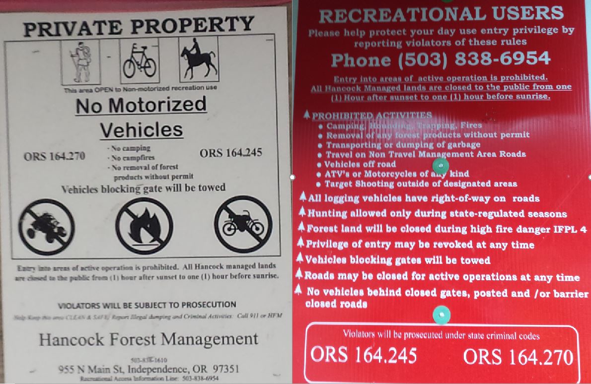


Sometimes they leave the gate open for logging traffic and contractors, even on the weekends. 


Be like Alicia, earn your turns and you too can smile knowing your toiling will go towards keeping access un-compromised for future paddlers.


NOMENCLATURE

Jason Rackley started the naming scheme on Gladiator Creek, I tried to stick to the theme he started.


Romulus and Remus: The first couple slides that start the upper run.  Romulus and Remus started Rome, which ended up being the naming theme for this upper section since gladiating occurred most famously in Rome and I ran out of applicable Gladiator terms.

Stout set of 4 drops:   Whoever runs them first can name them. 

Castrum RoadA castrum was a building, or plot of land, used by the Roman military as a fortified camp.

Triumfallades: A Roman Triumph was a huge parade sometimes given after a successful campaign that passed into the Pomerium (sacred part of Rome behind the walls).  The Triumfallades on Gladiator are a parade of big falls and cascades, passing through two pillars into a place that is as sacred a place as any to me. 

Pomerium: Meaning “behind the wall” in ancient Rome, it was a sacred open space located just past the Triumphal or Pomerium gates.  On Gladiator it is the space past the large bedrock pillars that the Triumfallades pass through, surrounded by massive rock walls and only accessible through the gate. 

The Skirmishes: A long section of continuous boulder gardens starting below the Pomerium and lasting to the middle bridge. The water was low for us during this section and while we only had one wood portage, there were plenty of other struggles navigating our loaded boats as we dodged wood, dealt with route finding, re-routing, rock-dodging, trying to stay studious about communication while keeping our eyes out for each other and downstream, along with pins, flips, traffic jamming, and deflections.


  ---


Vesuvius Falls: Mt Vesuvius was where the first battle of the third servile war (led by 3 Gladiators) happened, it is also the first notable obstacle on Middle Gladiator.  To get down the mountain the slave army had to use ingenuity to create ropes and ladders out of vines, it also takes creativity and involves ropes or a leap of faith to portage this falls.

Ludi: Games in general, and festivals involving games and parades.   These games could be private, public, or extraordinary, all things that are true of this parade of playful rapids that begin at the Rock Quarry access.

VenatorVenatores were skilled spearmen, usually pitted against carnivorous beasts.  The hole at this drop is of the carnivorous variety, then the whole paddle/spear metaphor seems to work.


---


Arena: Named by Jason Rackley and Pete Giordano, presumably because you can watch the show from the bridge.

Punisher:  Named by Jason Rackley and Pete Giordano, presumably because of the punishment this drop is capable of handing out, especially at high flows like they had.

Coliseum:  Named by Jason Rackley and Pete Giordano, presumably for the high cliffs overlooking the drop on river right.


This stream has been an ongoing project for me, and required many scouting missions and saw a number of failed attempts, these people each helped with a piece of the puzzle:  Rebecca Vogt, Sage Cruser, Tim Brink, Bruce (Ox) Reed, Pete Giordano, Jason Rackley, Rob Cruser, Dan Mccain, Ben Sigler (and his dogs), Bryan Carrington, Rick Cooley, Nate Merrill, Melissa Fowler, Rylie Coiteux, Jake Banta, Victor Repeto, Michael Freeman, Lucas Reitman, Willy Dinsdale, Ross George, Ben Mckenzie, Emile Elliot, Adam Edwards, and Joseph Hatcher.


  -jacob


Tuesday, May 7, 2019

Fish Creek (North Umpqua drainage)


We were camping at the Williamson campground after a couple days at the Sycan River.  I had really wanted the Williamson to be running, and while it had some water, we didn't want to tarnish our memory of it by running it too low.  We had gone to bed that evening planning to head up to the Miracle Mile the next day for some sunny laps at a nice flow.  Waking up I checked some flows to see if I had missed anything the day before, and noticed a creek that has been on my list for some time had dropped into an ideal flow during the night.  This was Fish Creek of the North Umpqua drainage, a creek that has fallen out of fashion after PGE and the Forest Service dumped truck loads of logs into it.  It had been running at what I calculated to be a high-runnable flow earlier that week, and I had expected it to stay there after a week of heat.  As it turned out, it had cooled just enough to drop it to what I felt would be the ideal flow to run it at, about 300 cfs.


Cooking cherry pie for breakfast.
Maybe the sugar rush helped sway Brandon to pass on a splash and giggle day in the sun on the Miracle Mile, for what was sure to be a trying day in a foreboding canyon.
Photo: Priscilla Macy


I had heard that before the Forest Service and PGE (FS/PGE) had dumped a bunch of wood in there for fish habitat, it had been considered one of the best class V runs in Oregon.  Since we had made the decision to paddle the creek pretty last minute, and would be getting a late start (12:30 by the time we got to the put in), we decided to treat the trip as a reconnaissance mission with the goal of finding out what Fish Creek was all about, while still getting out before dark.  We decided at the put in we would portage liberally in the name of making efficient downstream process.


The shuttle logistics are easy on Fish Creek, not typical for an obscure Oregon creek.  
Putting in at the NF-3701 bridge.
Photo: Priscilla Macy


There is a short bit of easy warm up before the first of the FS/PGE log jams.  We portaged this on the left, and boated down to the next eddy where there was another FS/PGE log jam on the right.


On top of the first FS/PGE log jam, looking down at the second.


 This second jam was passable, but leads in to Go-Fish, the first class V rapid.  Go-Fish is a giant boulder rapid that had a compelling line amongst various class V hazards.  We walked Go-Fish over boulders on the left, putting back in when the gradient cooled down.   The next 3/4 mile was mostly runnable boulder gardens with a manageable amount and location of FS/PGE log jams, each rapid requiring a look and some route finding.  We did walk a couple rapids in this section.

Brandon and Zach sorting out one of the boulder gardens.


After some time, things eased off for a moment.  The breather promptly came to an end at a sharp left bend in the river, and we eddied out on the right.  We crawled out on another FS/PGE log jam to take a peak downstream.  I recognized this corner as the entrance to the Flocked Gorge, the steepest section of the run dropping over 100' in the next quarter mile through a gorge and the point where a team of rafters attempting the run had bailed out in 2012.  We were looking at a chaotic boulder pile with logs sticking out of it turn the corner to the right as the creek entered the gorge.  This didn't look like a place we had time to sort out.  I looked up to the right and noticed I could see daylight through the trees, we surmised there must be a land-bench up there.  Looking at the satellite imagery I had downloaded onto my phone it seemed like if we got up to that bench and traversed a short way we might be able to portage the Flocked Gorge in it's entirety in one go, saving loads of time.  Brandon lead the way, finding a nice game trail that got us up to the bench much easier and quicker than anticipated.  Once atop the bench, we traversed and tried to maintain elevation for awhile, after 10 minutes or so we could see the creek at the base of a debris-free gully.  Another 5 minutes and we had scrambled down the gully back to the creek, from which we drank quite a bit of water.  I crawled out to look back up at the exit of what we had portaged, I was happy we had walked around it.


Looking back up at the exit of the Flocked Gorge, the visible rapid drops about 10'.

Given the portage only took 20 minutes and was much easier than we had anticipated, I'd again choose the full portage over dealing with the Flocked Gorge at river level if I return.  I do wish we had had the time to peak over the edge into the gorge during the portage though, to see what was in there.


 Our portage route around the Flocked Gorge.


Downstream the challenging whitewater kept up, there were numerous boulder gardens that each required a scout and contemplation.

At a point where a notable tributary waterfall entered from the right, the river bent left into the second gorge at the start of The ReddsThe Redds are smoothed out bedrock rapids amongst a run full of boulder gardens.  To reduce the route planning we walked the lead in boulder garden to the first of The Redds and concentrated on the tough to scout bedrock portion of the rapid.  This rapid ended up being difficult to view entirely from above and a pocket on the left was hidden during the scout.  One team member ended up in it (still in his boat) and needed a rope to get out.  A good location to throw the rope from was tricky to get to and after a couple failed tossed, I had to do some climbing to get upstream to a place where I could connect and pull him out.  He was beat after many failed attempts to get out while keeping from being pulled back into the hydraulic and the event made an impression on us as a group.  This was one of the few rapids that seemed mandatory, and the first person to go won't have safety.


 This is the first of The Redds, it does not have a reasonable portage option, the first person won't get safety, and while you can see the line from the scout, you don't see the hazard.  Just below and to the left (river-left) of Zach in this photo is the pocket, to his right is a shelf that offers safe passage.


 Downstream The Redds continue with more boulder gardens leading into bedrock rapids inside gorges, these gorges were all runnable and good quality even if they tend to look ominous from above.

Working our way through The Redds.

The Redds continue for a bit, some of these bedrock rapids have boulder gardens leading into them, some are stand alone.  The length of the day, the late start, and the earlier scare were starting to weigh on us as we continued to push downstream as efficiently as we could while keeping it safe and mistake-free. 


Challenging rapids continued as The Redds began to fade away and the creek returned to boulder gardens that were only occasionally interrupted by bits of bedrock.  Some rapids we ran and some we portaged.  The wood was present down here but we definitely portaged more rapids because they were hard than because of wood on this trip, with the majority of the rapids being runnable.  We were looking out for some powerlines overhead, because satellite imagery had indicated they marked the end of the hard whitewater.


Not out of it yet, tackling one a rapid at a time,.

Once the powerlines came into view we were faced with a final obstacle at Endgame, a landslide rapid providing one last major puzzle to sort before things cooled down.  Endgame looked heinous from above with full sized trees stripped of their bark jutting out of the boulders, aimed skyward.  We didn't bother looking at it and portaged left.  The landslide kept us from being able to portage all of Endgame at river level though, so I set about trying to scout the bottom corner of the rapid, which looked like it might allow passage.  Whether we could paddle through the corner or not was likely going to be the difference between finishing with light to spare or having to find an up and around route with the likely result of finishing the trip in the dark.  I squeezed up and through some logs to a point I could see the corner was clear and there was a nice eddy on the right.  However there was also a visible logjam downstream and the corner move into the eddy was not a gimme.  We weighed the risk of the move to the risk of paddling in the dark and decided to paddle the corner into the eddy.  

A low water photo of Endgame from below, the surveyor is standing in the eddy we caught above the log jam.  The photo is taken from on top of the log jam.


Once in the eddy, we were able to see that there were two more eddies immediately in front of the log jam on either side if the surveyor eddy had been blown, so it would not be as nerve racking on a return trip.  I also noted upon looking back upstream the trees in the rapid did not block the line, and the rapid was runnable class V.  A quick portage on the right around the jam and we made short work of crossing under the powerlines, breathing a little easier now with only 1.5 miles of read and run left on Fish Creek.  Turning left onto the North Umpqua there was less than a mile left of class II and within 30-40 minutes of passing under the powerlines we had reached the take out bridge, highly impressed by Fish Creek and happy to be done with 30 minutes of light to spare.

Most of the photos of Fish Creek were taken from my cell phone, in stark contrast to the quality of Priscilla's photos found in most of the recent trip reports on this site.


FLOWS

Fish Creek runs most predictably in the Spring from snowmelt.

Our flows for the day in the USGS 14315950 FISH CREEK ABV SLIPPER CREEK NR TOKETEE FALLS, OR


The gage is right there at the put in, producing an exact representation of what you will have when paddling the creek.  300 felt like a good flow, it could be done with more or less water based on your personal taste.  It is worth noting that there is a diversion upstream, and that can change the flows abruptly on rare occasions (up to 150 cfs).  If this is going on the change will be visible on the regular gage.

 The gage station at the put in.                                                         It was reading 4.8' when we put in.


ACCESS


 Click on the graphic to enlarge.


Take out at the NF-4775 bridge (43.295861, -122.478533) over the North Umpqua River, a left turn about 39 miles upstream from Colliding Rivers Boat ramp/Glide on Highway 138 and about 4 miles downstream of the Toketee Falls turn-off.

To get to the put in (43.229973, -122.447593) return to highway 138 and head upstream/east 6.2 miles past Toketee Falls and turn right towards Watson Falls on Fish Creek Rd/NF-37.  In 2.9 miles turn right onto Camas Creek Road.  In about 2 miles you will pass the Toketee Airstrip, according to the Diamond Lake Ranger Station the road gets plowed of snow up to this point.  The Ranger Station can be reached at (541) 498-2531 to confirm.   After passing the airstrip it's 1.4 miles to the bridge over Fish Creek.

The Toketee Airstrip has a SNOTEL site.


-------------------------------------------------------------------------------------------------------------------
Nomenclature and History
-------------------------------------------------------------------------------------------------------------------


Go-Fish:  Because of the card game.

Flocked Gorge:  This is the stoutest gorge of the run, located near where Gabe Flock pinned on an early descent of Fish Creek, loosing his gear and nearly his life.  The gorge isn't totally f**cked, but it is close.  Inside are all of the hardest types of features found on Fish Creek crammed into a gorge and turned up to 10.  This was the final straw for a rafting attempt of the creek that decided they had had enough and hiked out after peering into the Flocked Gorge.

The Redds:  Salmon find gravel strewn sections of river to lay eggs, they kick up the gravel to smooth it out and lay their eggs.  These smooth spots where the eggs are laid are called salmon Redds.  Most of Fish Creek is full of boulders, except this portion of the run where there are intermittent smoothed out sections of bedrock inside short gorges.

Endgame:  This is the final class V obstacle on the creek, the rest of the creek was read and run and portage-less below this rapid. The stress-level drops considerably once past the powerlines, which are just below this rapid.


 ---------


Fish Creek of the Umpqua drainage has an interesting boating history.  It rumbles through a class V canyon with bridge to bridge access near Toketee Falls, flowing parallel to Copeland Creek.

In 2000, the legendary Dan Coyle did a solo trip down Fish Creek, putting it on the map for boaters.  He wrote up a description, but that document is no longer available online (that I could find).

From the pdxkayaker forum archive


 A few years later, there was a bad pin between the first large cascade (Go-Fish), and the crux gorge (Flocked Gorge).  The paddler survived, but it was a close call.  "My air pocket was gone by then, and my knee and ankle were twisted badly and my foot still caught by the cockpit as I was mostly free but now facing up and the brunt of the flow still on me. I had to do another superman move with no breath yet! Pulled myself up far enough to get my foot out thank god"

Then came the wood.  An attempt was made by the boating community to have boater safety considered when placing fish habitat in this creek.  I don't know the full story, but the end result was the wood was placed anyway, and in a fashion that didn't take into account recreational boating.


Fish Creek, a contender for the best class V adventure run in Oregon, descended into obscurity as paddlers learned from each other through either word of mouth or the hard way about the placement of the wood.

Fast forward a half decade, and that obscurity played a roll in the next documented descent of the creek.  A group of rafters was in the area, and the "itch for an adventure hit some of [them] like a bad case of poison oak".  Because the creek had fallen off the radar, it wasn't common knowledge in the boating community what was on the creek, or that it was full of logs placed by the Forest Service and PGE.

These rafters found their adventure, and then some.

I am not the only boater who has noted Fish Creek on a map during the last half decade, or while driving over on Hwy 138, gotten curious and raked the internet for information, to turn up only the story of the rafters, which was pretty hard to look past.  However, when I read between the lines, I got the impression their by-the-book approach would have led to a similar experience on any class V run of that nature. 

I spent some time digging a little deeper and turned up some snippets of information from the pdxkayaker yahoo forum (screen grabs seen above), saw some rumblings about past debacles on facebook, viewed satellite imagery that appeared to show a manageable wood situation, and fed off enthusiasm from other boaters who also wanted to find out what Fish Creek was all about (namely Mike Goglin and Joseph Hatcher, but also others around various Oregon campfires).

By 2015 it was a top five objective for me, but year after year I let opportunities slip by.

Then, waking up near Chiloquin after a great couple days on the Sycan in the Spring of 2019 with plans to paddle the Miracle Mile on the way home I perused some flows while killing time in the morning.  Fish Creek had been holding at what I felt would be at the high end of runnable all week so it hadn't even been something I was holding in the cards for this weekend, yet despite warm weather the gauge dropped to exactly what I wanted to see it at for my first trip (~300 cfs, like the rafters had).

I sent a text to Mike, who I had been planning to run Fish Creek with this year if the opportunity arose, lamenting the missed opportunity.  As it happened he was out of town anyway and I knew from conversation earlier in the week Joseph wasn't available either so I wasn't too bummed I hadn't been prepared for the opportunity.  I mentioned it in passing to the group from the Sycan at breakfast, figuring we had already done some exploring this weekend and everyone was probably ready to take 'er easy on the way home.  To my surprise both Zach and Brandon were all about it, Zach even mentioned tongue-in-cheek that he felt we had been jipped by the lack of suffering on the Sycan, and had aspirations Fish Creek would deliver the adversity we had evaded so far.  Since we had been planning a casual day we were getting a late start, but as it turned out, from where we were camping it was less than two hours to Fish Creek and it was sort of on the way home.  With info from the Diamond Lake Ranger District that the road would be plowed to at least within a mile and a half of the put-in, a gung-ho group, and a sunny day with perfect flows, this wasn't an opportunity to be missed.

Priscilla and I sorted out logistics on the drive over (she was going to be taking the day off from boating), and by 12:30 Zach Levine, Brandon Lake and I had driven a snow-free road to the put in and were floating under the access bridge on Fish Creek.

Photo: Priscilla Macy


By the end of the day there had been two throw-rope saves, loads of scouting, a fair bit of portaging,  and oodles of good rapids run.  Upon arriving at the take out and mentally exhausted from the no rest, full speed, quick decision making, no mistakes allowed 8 hour reconnaissance mission down Fish Creek, I had claimed it was a one time trip for me.  Less than a day later, after a good night of sleep, I was already looking forward to my next time in there.  Though an early start will be a prerequisite.

It really is a hell of a run, the wood from the Forest Service has shifted and while there are some portages and an added level of attention is required, the good outweighs the bad on Fish Creek.  If you are an adventurous boater who likes runs similar to the Clear Fork Cowlitz, you will be happy to know we have our own flavor of full day adventure right here in the heart of Oregon's Cascades.

And it runs from snowmelt!


    -jacob