Showing posts with label upper. Show all posts

Wednesday, April 22, 2020

Gladiator Creek

AFTER ALL THE TRIPS I DID ON THIS CREEK THE ACCESS HAS CHANGED.  BOATERS MUST NOW PURCHASE THE BLACK ROCK ACCESS PERMIT FROM WEYERHAEUSER TO RUN THE CREEK.  LAST I CHECKED A VEHICLE PERMIT WAS ABOUT $350, AND A WALK IN PERMIT WAS $75.  ANY REFERENCES TO FREE ACCESS ON THIS PAGE ARE NO LONGER CORRECT.


 Photo: Adam Edwards


Gladiator Creek is my favorite run in Oregon's Coast Range.  It's been on ongoing project for me since my first year at Western Oregon University in 2008.  This was one of a group of three creeks in the Valsetz area of the Coast Range that laid the foundation for what boating means to me, through the challenges they presented both on and off the water.  Iv'e written about the different sections of Gladiator Creek a few times on this site, but this is the page that puts them all together.  Access is both straight forward and tricky, linked below is a story from the superstars of Oregon exploratory kayaking detailing the challenges they faced paddling the lower section for the first time in the early 2000's

**ownership has since changed and there is no longer a legal barrier to running this creek.**
Photo: Priscilla Macy


It's not a typical PNW creek.  The creekbed is sandstone, and seems like something you would find on the East Coast.  Also like the East Coast, flows can rise and fall quickly.  This means the best laid plans can be laid to waste if a storm you are counting on the night before drops too little or too much precipitation overnight.  For me, the rewards have been worth the consternation.  While the 7 waterfalls stand out as highlights, it's the numerous class fun rapids between them and unique setting that keep me coming back.


After many scouting trips, failures, and a few successes on the lower few miles of Gladiator creek, the biggest piece of the puzzle was placed when Ben Mckenzie, Emile Elliott and I paddled the middle section in 2015.  We got lucky with flows and had a great time, with the highlight being perfect levels for the first descents of the ultra clean Vesuvius Falls.  Then in October 2019, a decade after first seeing this creek on a map, Ben Mckenzie, Adam Edwards, Joseph Hatcher and I ran all three sections top to bottom over a two day period with Priscilla running shuttle for us.   After years of work, and many weekends agonizing over levels and access it had finally been put together top to bottom in one push.   With the information gained on these trips, I now feel comfortable going to Gladiator any given weekend the conditions line up, with the logistics as locked in as I could ask for.
And while it's not a run for anybody, now that access is sorted out and no legal barriers are present, despite the effort required everybody who has done it has been glad they did and have been up for returning.
 Photo: Dax Kirkwood


Looking back on the influence this creek has had on my thoughts and decisions over the years, I don't think any other stream has defined kayaking for me more than Gladiator has.  Each time I paddle the creek, I leave thinking there is not another stream in Oregon I feel more entwined with than this one.
Photo: Priscilla Macy


Below are links to descriptions for what you can find on each of the three sections of this creek.


This is the most adventurous section, and if you want to give the big drops a real look, plan on doing this section over two days.


MIDDLE  (3 miles)
IV-V
This section is a contender for the best day of creek-boating you can get in Oregon.


LOWER  (4 miles)
III(IV,V)
While there are only 3 notable rapids, they are 3 of the more unique and enjoyable rapids in the state.


Lastly, the part I paddle most often, with the most bang for your buck.


IV-IV+
This run begins part way through the Middle section (below Vesuvius Falls) and gives a good option for those not interested in Vesuvius Falls.  This is the section I'll do any given day, there is plenty of class fun whitewater without the commitment of what is found upstream.  It starts 1.5 miles above the Lower put in bridge.


FLOWS:  The gauge is located at the only place the creek runs along the highway, the creek is visible here through the vegetation if you are looking for it.  This proximity occurs just as you are entering a small town if coming from the east.   There is a guard-rail there, and if you park on the west side of the guard rail (across from the liquor store) you can walk back to the east 75 feet to where some yellow paint is splashed on one of the posts supporting the guard-rail, marking the point along the guard-rail closest to the gauge.  The gauge is just a few wooden shims with numbers on them, glued onto a rock.  It's behind a couple trees adjacent to that yellow paint and about 20 yards upstream of the small riverwide ledge/hole/wave (depending on flow) visible in the photo below.

The visual gauge on Gladiator Creek, and what you might be able to expect based on an approximate correlation to the flow in the Salmon River below Slick Rock Creek Gauge.


Data points


There is more information on each of the section pages about how flows pertain specifically to that section.  There is also more detail and the opportunity to nerd out on this other page where I keep notes on historic flows and jot further notes on levels.


ACCESS:   As of 2020 the private logging company who owns all the land the creek runs through allows walk in access.  Access is detailed on each individual page.


 I have stuck with the moniker given to the creek by Oregonkayaking.net, who were paddling the creek under the radar on the first descent of the lower section.  While the access situation is improving, and currently there is no red-tape or legal barriers to hiking in and paddling the creek, leaving the name off the internet seems like a good way to keep that status quo.  Along that same vein Iv'e always tried to keep a low profile when hiking into and paddling the creek, but smiling at anyone working back there and think that mentality will go a long way towards keeping access from being barred to future paddlers.  I have left enough information about how to access the different sections on their individual pages (linked above) and this one that someone who has the wherewithal necessary to paddle a creek like this will be able to sort it out just fine.  If after all that you think you have the logistics sorted, but end up failing at your attempt and leave this Rock un-turned, you could always give your luck another try at the nearby casino.

 Photo Emile Elliott


While there was a time that driving to the put in was allowed on weekends during hunting season, public vehicle access has since been barred.  This has come at the gain of the public being allowed to hike into the creek on nice gravel roads any day when the fire danger is not high, though I try to stick to the weekends to keep from getting in the way of daily operations or getting skunked if they are blocking the road.   I personally prefer the new situation to the old, given how uncommon it was for this creek to run at a good flow on a weekend during hunting season.  While the hiking is straight forward, the distance is not short (3-6 miles depending on the access point and section).  I typically use these, but a variety of carrying systems have been deployed, even the old shoulder.

Does smiling with a kayak strapped to your back count as a lie?
Photo: Dax Kirkwood


RULES


There are some rules to be followed if you plan to kayak this creek.

Follow this link to zoom in on the map and bullet points(zoomed to in second graphic).  The areas inside the green on the map are open to walk in access.  As of 2020 the Gladiator Creek watershed is entirely within the green area. You can double check the kiosk near the bottom gate before starting your hike for updates.


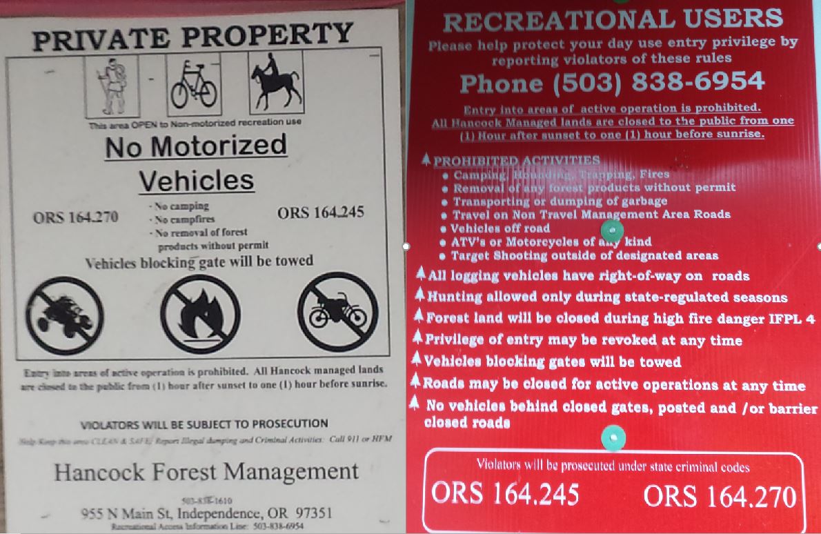


Sometimes they leave the gate open for logging traffic and contractors, even on the weekends. 


Be like Alicia, earn your turns and you too can smile knowing your toiling will go towards keeping access un-compromised for future paddlers.


NOMENCLATURE

Jason Rackley started the naming scheme on Gladiator Creek, I tried to stick to the theme he started.


Romulus and Remus: The first couple slides that start the upper run.  Romulus and Remus started Rome, which ended up being the naming theme for this upper section since gladiating occurred most famously in Rome and I ran out of applicable Gladiator terms.

Stout set of 4 drops:   Whoever runs them first can name them. 

Castrum RoadA castrum was a building, or plot of land, used by the Roman military as a fortified camp.

Triumfallades: A Roman Triumph was a huge parade sometimes given after a successful campaign that passed into the Pomerium (sacred part of Rome behind the walls).  The Triumfallades on Gladiator are a parade of big falls and cascades, passing through two pillars into a place that is as sacred a place as any to me. 

Pomerium: Meaning “behind the wall” in ancient Rome, it was a sacred open space located just past the Triumphal or Pomerium gates.  On Gladiator it is the space past the large bedrock pillars that the Triumfallades pass through, surrounded by massive rock walls and only accessible through the gate. 

The Skirmishes: A long section of continuous boulder gardens starting below the Pomerium and lasting to the middle bridge. The water was low for us during this section and while we only had one wood portage, there were plenty of other struggles navigating our loaded boats as we dodged wood, dealt with route finding, re-routing, rock-dodging, trying to stay studious about communication while keeping our eyes out for each other and downstream, along with pins, flips, traffic jamming, and deflections.


  ---


Vesuvius Falls: Mt Vesuvius was where the first battle of the third servile war (led by 3 Gladiators) happened, it is also the first notable obstacle on Middle Gladiator.  To get down the mountain the slave army had to use ingenuity to create ropes and ladders out of vines, it also takes creativity and involves ropes or a leap of faith to portage this falls.

Ludi: Games in general, and festivals involving games and parades.   These games could be private, public, or extraordinary, all things that are true of this parade of playful rapids that begin at the Rock Quarry access.

VenatorVenatores were skilled spearmen, usually pitted against carnivorous beasts.  The hole at this drop is of the carnivorous variety, then the whole paddle/spear metaphor seems to work.


---


Arena: Named by Jason Rackley and Pete Giordano, presumably because you can watch the show from the bridge.

Punisher:  Named by Jason Rackley and Pete Giordano, presumably because of the punishment this drop is capable of handing out, especially at high flows like they had.

Coliseum:  Named by Jason Rackley and Pete Giordano, presumably for the high cliffs overlooking the drop on river right.


This stream has been an ongoing project for me, and required many scouting missions and saw a number of failed attempts, these people each helped with a piece of the puzzle:  Rebecca Vogt, Sage Cruser, Tim Brink, Bruce (Ox) Reed, Pete Giordano, Jason Rackley, Rob Cruser, Dan Mccain, Ben Sigler (and his dogs), Bryan Carrington, Rick Cooley, Nate Merrill, Melissa Fowler, Rylie Coiteux, Jake Banta, Victor Repeto, Michael Freeman, Lucas Reitman, Willy Dinsdale, Ross George, Ben Mckenzie, Emile Elliot, Adam Edwards, and Joseph Hatcher.


  -jacob


Thursday, August 3, 2017

Cispus: Super Slides


Photos:  Priscilla Macy

BETA


More beta for this run can be found here, and here.

Stream: If you put in on Goat Creek with a similar configuration of trees as we found in 2017, you will find a small stream with numerous portages around logs and some loose boating.  If you put in on the Cispus, you might have a quick portage or two before the slides start.  Of the two approaches, I preferred the second.  It requires about 30 minutes of downhill walking through open forest, the classic Northwest forest allowed for easy dragging.

Once you reach the Cispus, the stream is consolidated and there are a couple class III-IV rapids before the first horizon line which can be easily scouted on the right.  From this point to a point less than 1/4 mile above Walupt Creek Falls the stream is continuous slides.  All fun, all straight forward.


The trick is finding eddies, when there is enough water for the run to be fun, you need to scout eddy to eddy which can take a fair bit of time/effort.  The first lap took us 4-5 hours, the second lap (once we knew the run) took us less than 15 minutes.  

The scouting and eddy situation starts out friendly once on the Cispus and slowly works its way towards tricky as the slides bend around sharper corners.  Nannie Creek enters the Cispus over the below pictured waterfall.  This falls is a good indicator of having reached the finale, the rapid above it is the first corner that requires creativity to scout.

The river bends right below the Nannie Creek confluence (last easy eddy), back to the left and then drops away steeply into the finale.  Once past the horizon line, paddlers are committed to nearly 1/2 mile of continuous slides.  It took about an hour to scout the first time high on river right, which we were able to do thanks to Adam making a dicey eddy and pulling us in out of the slide one at a time.  Once at Nannie Creek Falls, don't leave any eddies until you know how to get into the next one, or are comfortable committing to the next half mile of slides.  The second trip we knew it was clear so didn't scout and it took just a couple minutes to run.  The line for us was to stay center, justified to the inside of any corners.  

                            The steepest part of the final 1/4 mile, from Adam Edward's perspective.


This final 1/2 mile rapid below Nannie Creek ranks up there with one of my favorite rapids of all time, I felt the effort of the run was totally justified by the largest scale class III-IV rapid Iv'e ever run.  Giggles all around.  The whitewater soon peters out and then ends where Walupt Creek falls enters on the left.  There was a surf wave and rocky beach here, making for a nice lunch stop.


After taking in Walupt Creek Falls, it's time to head downstream.  If you are taking the trail out (a little under 1/2 mile downstream of Walupt Creek), keep an eye on river left.  After passing the second notable rockslide, there will be a 30 foot high cliff on river left visible downstream.  Eddy out just below the cliff on river left.  Walk up to the bench 10 feet above river level, you should see another rockslide at this point.  Parallel the river along the bench until you come across a trail, follow this trail up to the vehicles.

If you are using the bridge take out, you will enter the swamp a short distance below the final rockslide.  Downstream progress will become difficult for 1/4 mile as you portage through the swamp.  The river re-consolidates a short distance above the bridge.


Flows:  We ran this twice in June 2017, The Cispus was flowing from snowmelt with bumps from significant rain.  June 16 was a fun, friendly flow.  June 18 was a little lower, but still worth it.  Word is 3,000 is medium, give or take 1,000 cfs to get the range of low to high, 500 cfs or more than that in either direction are pushing into the distant edges of runnable.  Eddies are the limiting factor on this run, they were scarce at low flows.  So if you knew the run and that it was clear of wood, you might be able to push the flow levels up a bit if you were willing to forgo scouting.


Access:  The standard route into the area (NF-23 out of Randle) was not passable due to the road being washed out by the Cispus River near Blue Lake.  We took NF-21 paralleling Johnson Creek (which looked like it was at a friendly flow).  For that route, leaving Hwy 12, take NF-21 16 miles and turn left toward Walupt Lake.  Cross the Cispus 1.5 miles later.  This would be the preferred take out, except there is a 1/4 mile long portage through a swamp if you choose that route.  We chose to continue another 1.7 miles to a trailhead, where you can hike about 3/4 of a mile uphill at the end of the day to avoid the portage.

Bridge Take Out:  46.4146, -121.5244
Trail Take Out:  46.4234, -121.5011

To get to the put in return to the bridge across the Cispus and head back towards NF-21.  If you have a high clearance vehicle you may choose to take a short cut shortly before reaching NF-21 on NF-2152.  If you have a Subaru, continue to NF-21 and turn right.  There is a map below that lines it out, but here are the step by step directions as well


 Continue 2.9 miles and turn right again on NF-2150 (the road becomes unmanaged).  Another 1 mile and turn right onto NF-2152, and in another 0.6 miles left onto NF-016 (the road can be rough).  In 0.9 miles there will be a spur road going off to the left (don't take it), in another hundred yards you will notice a small marshy-pond to the left, park here.  Follow the rivulet leaving the marshy-pond down to the Cispus, the distance is under 1 mile.  You will know you are close when you reach a second marshy-pond area.


                                                                    NF-016


If you want to put in on Goat Creek, just continue past the marshy-pond to the end of the road.  Goat Creek is visible from there.  

Hike in to the Cispus:  46.4494, -121.5144
Walk in to Goat Creek: 46.4585, -121.5102


Paddlers:  Adam Edwards, Whitney Butler, Brandon Lake, Priscilla Macy, Jacob Cruser

Monday, October 24, 2016

Thomas Creek: Pumpkin Patch

Each October hunting season rolls around and access to Thomas Creek is allowed.  Like a pumpkin patch you can go in just a short way and get a worthwhile reward, but if you want the biggest and the best you gotta go just a little further.


BETA

Stream: Walk down the short nose of land and put on to a Thomas Creek that has noticeably less water than where you left the take out vehicle.  A short warm up ends at an island, while most of the water goes right I suggest taking the left channel.  Immediately after the channels merge back together the whitewater gets rolling in the form of manky (if you are not on line) class IV whitewater that can and should be scouted.  There is an eddy on the left before the creek turns right and pinches down to half its size between a couple boulders.   It is important you catch an eddy right or left just below this pinch to scout the rest of the rapid, which makes a bend to the left and over "Pumpkin Spice".

Pumpkin Spice has a narrow hallway leading to a ten foot ramp that must be run right (without hitting the right wall) to avoid an atomic piton middle and left.  The line is straight forward, but don't mess it up.  Scout/portage the lead in and Pumpkin Spice on the left, safety can be thoroughly set below.

                                                   Ross George enjoying this seasonal treat.


A nice boof and a short bit of easy water lead to another island that is best run in the right channel (ducking a couple logs at the top in 2016).  Shortly below this island is a bridge, then some easy floating through some island and boulder bar style rapids before the whitewater builds again as the creek approaches and then passes under another bridge.  This second bridge signals that you are VERY close to Thomas Creek Falls, separated by only two short class III-IV rapids.  There are small eddies just above the plunge, that should be caught one boater at a time.   If you are feeling cautious or the water is high you can chose to walk down to the falls from this bridge along the road and then down a short trail.

The line on the 30-40' Thomas Creek falls is obvious along the right side and away from the log in the center.  The lead in is straight forward, the landing soft and the pool friendly.  The log is intimidating and would likely be disastrous to collide with.  Boaters around here typically assume if there is a runnable drop in the area it was likely run back in the day by Eric Brown or Dan Coyle.  Yet not knowing for sure, this drop did not see a descent for many years (the log was cited as the concern).  In 2010 Matt King demonstrated to our generation of boaters that the line is manageable for skilled paddlers.  Since his run, numerous others have followed.

                                                    Kory Kellum staring down the barrel. 


Thomas Creek Falls can be portaged via a thrown and go from the lip on river-right, or a sloppy up and around route on the same side.

Patrick Beville sans boat


Below the falls are a couple more III-IV rapids in a gorge before the stream flattens out for awhile.  Somewhere amongst these boulder bars you enter the Standard Stretch, and about 4 miles of beautiful and classic class III-IV whitewater later the take out.

Vaclav out front

  
Flows: We had ~1,000 cfs and dropping slow.  I'd guess 900-1500 cfs is a reasonable range on the USGS Guage @ Scio (and it's probably ok if the gauge is reading a bit higher so long as the flow is dropping).    If levels are lower you can still put in at and run the falls (down to 400 or so cfs).

Access: The take out is located less than 15 miles East of Scio, OR.  Take Hwy 226 to Thomas Creek Dr, following until it turns to gravel which is where the gate is.  If it is Cascade Deer or Elk hunting season, the gate has historically been open (call this number to be sure 888-741-5403).  If not, it will be closed and your only option is to find access through the Santiam State Forest via the Rock Creek drainage out of Mill City or hike a long way.

Assuming the gate is open, continue along Thomas Creek Drive 2.2 miles (past the Sheriff's posse) and make a right turn down to the take out bridge.

To get to the put in return to Thomas Creek drive and continue the way you were going 3.8 miles (stay right at 2 and 2.9 miles) where you will meet up with a more heavily travelled road, merge right.  2.9 miles past this merge (stay straight at 1 mile, drive through a yellow gate shortly after, then pass the road leading down to Thomas Creek Falls at 1.8 miles) you will cross over Thomas Creek, there will be notably less water than at the take out. Stay left on the road along the creek, 3/4 of a mile past this bridge you will reach another bridge over a tributary with an obvious parking area.  Walk down the nose of land to the creek to put in.

A mileage map starting at the take out.
It is worth cache-ing this area on your phone before leaving reception and using the GPS if you have that function.
click to enlarge


Notes:   My friend Jarred voiced concern about the right wall below the falls appearing undercut on a trip he took to Thomas, and thus chose to portage the falls.  I have been there at low flows and it was not an issue.  At the flow the pictures for this page were taken we had about 1,000 cfs and the wall proved to still be a benign obstacle.  Anything that flowed towards it was stopped short of the wall by the water rebounding off the wall short of collision, and subsequently pushed quickly downstream into the pool.  We were even comfortable jumping off the falls and swimming past the wall.  The clips below were put together to showcase how the wall can be...

A) avoided
B) a non-issue if you are pushed toward it

That said, analyze the situation for yourself when you are there.  Especially if the flows are up.


----------------------------------------------------------------------------------------------------------------------------------------------
Trip Report
----------------------------------------------------------------------------------------------------------------------------------------------


The day before Emile and I had checked out Thomas Creek from the top, exploring 7.5 miles of stream I knew nothing about aside from what I had seen on maps and a tantalizing picture Pete Giordano had sent me.


It was a fun day of adventure, though we had portaged the rapid Pete sent the photo of.


The next day a group of boaters wanted to go to Thomas so we planned on giving the rapid a better look before continuing through the falls and Standard Stretch.

A couple boaters in the group were uncomfortable putting on this high so planned to meet us at a bridge above Thomas Creek Falls.  We walked down to Thomas Creek near a confluence and quickly worked our way down to where the whitewater picked up.  The scouting and safety setting took some time, but eventually Priscilla decided to go first.  We felt that because she was in an IK on this trip it gave her more margin for error with the padding those craft provide.  She ended up getting spun at the lip and dropping over backwards but came out upright and unscathed.

Ross went next with a perfect line, with Kory and I following not long after.


  It took us a little while to get down to the bridge to meet the rest of the team who were pretty worried it had taken us 1.5 hours to run that section.  They decided that since it was now 2pm and it would be dark by 7pm they were not comfortable continuing on for fear of running out of light, we wished them well and continued on downstream.

There was a section of easy floating before the whitewater picked back up as we reached another bridge.  This signaled we were near the falls so we proceeded cautiously down the next couple of short rapids.   We caught the eddy on the right above the falls one at a time and set about scouting or portaging Thomas Creek Falls.

Kory went first, followed by Nick, Ross and myself.  The others chose to save this one for another day.

Nick hopped in the IK for this one.


We continued on through the classic Standard Stretch, having a blast and arriving back in Albany before the sun faded.   Aside from Ross getting lost on the shuttle the day went very smoothly.


  -jacob

Thursday, March 10, 2016

Blue River Bounty


The Blue River drainage is a staple for the Eugene boating community, and its a drainage that I have been wanting to check out for awhile now.  After a long weekend of driving, we were happy to stay in the valley for MLK day.  We woke up to the Blue running over 1,000 cfs so decided to give it a go.


January 18


Being turf of the Eugene boating community, I garnered all my beta during the week from Nate Pfiefer's Wheels and Water blog aside from a helpful hint from Bobby Brown on another creek in the area.

Bobby's contribution.


Priscilla and I collected Emile Elliott on our way south, then met Ben Mckenzie in Eugene.  He is recovering from a shoulder injury, so was taking pictures today and making it possible to maximize our boating options by running shuttle.

Ground Support for the day.

All photos in this report by Ben Mckenzie unless otherwise marked.


First on the hit list was the Upper Upper Blue River
(Beta Here).


We wanted to skip the portaging in the upper stretch, so followed the overgrown 535 road which branches off the main Blue River shuttle road 1 mile past the Quentin Creek bridge.  We followed this overgrown road to a point where we could easily access the creek.  This occurred where the road started to disappear and an obvious route down to the creek was visible.

Our path is highlighted in black.  Route modifications are available.


We put in just below a bit of an island and just around the corner was the odd box noted on Nate Pfiefer's report.  A direct hit in terms of where we wanted to enter the creek.

Our Put in on the Upper Upper Blue.


This run was full of non-stop class III+ or IV- slides with a couple more channelized rapids near the end.


We had only one wood portage and made it to the take out at the confluence with Quentin Creek in short order.

Next was Quentin Creek
(Beta Here).


I think we were all the most excited about this one because of the fun looking slide/falls.  Unfortunately for us, less than a half a mile up the shuttle road we came across a logging unit whose work site blocked access further up the road.  We decided that the mile+ hike in and bushwhack would eat up the rest of the day.  We had more fish to fry, so saved this one for another time.

Nate Dogg has gotten in there, here is his POV of the run.

We detoured to Cook Creek, where another road block (this one in the form of numerous logs across the road) turned us back yet again.  That was probably ok, as it didn't look all that good on the maps.

We had beta from Bobby Brown that Tidbits Creek was pretty fun, so drove upstream to where Ore Creek flows under the shuttle road via a large culvert.  Emile and I paddled through this culvert and into the non-stop action of Tidbits Creek.


The run was fast paced class IV fun with a couple of ledges and two short log portages.

Status Quo on Tidbits Creek.


There was one ledge that was pretty ugly which Emile ran right on verbal beta from me.  The result was of the sort that I then chose to portage, sorry Emile.

 For anyone debating whether it is worth touching up on those play boating skills, Emile makes a strong case for doing so in the clip below.

Just downstream of this dubious ledge was a short portage, it was fortuitously placed as Emile found a whole bunch of Ganoderma Oregonense, a mushroom which can be made into a tea and are reported to boost ones immune system.  Also called the "mushrooms of immortality".

We passed these mushrooms off to the ground team at the second portage.


Below the second and final log portage was more fast paced, fun whitewater that was all boat scoutable.  Near the end of the run was a ledge we had seen driving up.  We scouted what turned out to be the signature drop of the run.

Boofing through Tiddlywinks.


While waiting in the eddy downstream for the ground crew to shuffle around for photos, Bobby Brown (the boater who had told us about this run) showed up with his dogs.  There was one more sticky hole that was easily punchable on the left, then some more fun cruising down to the confluence with the Blue River.

The sticky hole, fortunately its an easy move on the left.


Bobby had his boat with him so we decided that a quick lap on the classic section of the Blue sounded like a fun thing to do, we all drove up to the put-in where Brian Ward happened to show up as well.


Priscilla, Emile, Bobby, Brian and I then joined forces for a fun lap on the Blue River.  There was one quick wood portage on the right (gone as of Feb 2016), and the rest was fun and splashy III-IV with some neat moves and friendly hydraulics.  Bobby and Brian knew the run well so we were able to move along at a nice clip.


After finishing that one up, we walked up the road for a quick trip down the Lookout Creek slide.  It was enjoyable and next time I'll aim to paddle more of what is upstream on that creek.  Next we ran shuttle and headed over to scout out the headwaters of Quartz Creek.  While we were not overly impressed by what we saw on Quartz Creek, we were pretty impressed with Bobby's snow driving ability.  Nate (Merrill this time) has run some of the stretch above the normal put in and reports at least one unique IV-V rapid that is not visible from the road. The sun was setting at 5PM at that time of year so that about wrapped up our day.

Lookout Creek Slide.


I was pleasantly surprised by the quality of the whitewater in the Blue River drainage and hope to return again some day.


The wood situation is pretty good right now, so get it while its hot.


Here is a map if you want to orient yourself with the streams mentioned in this report.


        -jacob