Showing posts with label middle. Show all posts

Wednesday, April 22, 2020

Gladiator Creek

AFTER ALL THE TRIPS I DID ON THIS CREEK THE ACCESS HAS CHANGED.  BOATERS MUST NOW PURCHASE THE BLACK ROCK ACCESS PERMIT FROM WEYERHAEUSER TO RUN THE CREEK.  LAST I CHECKED A VEHICLE PERMIT WAS ABOUT $350, AND A WALK IN PERMIT WAS $75.  ANY REFERENCES TO FREE ACCESS ON THIS PAGE ARE NO LONGER CORRECT.


 Photo: Adam Edwards


Gladiator Creek is my favorite run in Oregon's Coast Range.  It's been on ongoing project for me since my first year at Western Oregon University in 2008.  This was one of a group of three creeks in the Valsetz area of the Coast Range that laid the foundation for what boating means to me, through the challenges they presented both on and off the water.  Iv'e written about the different sections of Gladiator Creek a few times on this site, but this is the page that puts them all together.  Access is both straight forward and tricky, linked below is a story from the superstars of Oregon exploratory kayaking detailing the challenges they faced paddling the lower section for the first time in the early 2000's

**ownership has since changed and there is no longer a legal barrier to running this creek.**
Photo: Priscilla Macy


It's not a typical PNW creek.  The creekbed is sandstone, and seems like something you would find on the East Coast.  Also like the East Coast, flows can rise and fall quickly.  This means the best laid plans can be laid to waste if a storm you are counting on the night before drops too little or too much precipitation overnight.  For me, the rewards have been worth the consternation.  While the 7 waterfalls stand out as highlights, it's the numerous class fun rapids between them and unique setting that keep me coming back.


After many scouting trips, failures, and a few successes on the lower few miles of Gladiator creek, the biggest piece of the puzzle was placed when Ben Mckenzie, Emile Elliott and I paddled the middle section in 2015.  We got lucky with flows and had a great time, with the highlight being perfect levels for the first descents of the ultra clean Vesuvius Falls.  Then in October 2019, a decade after first seeing this creek on a map, Ben Mckenzie, Adam Edwards, Joseph Hatcher and I ran all three sections top to bottom over a two day period with Priscilla running shuttle for us.   After years of work, and many weekends agonizing over levels and access it had finally been put together top to bottom in one push.   With the information gained on these trips, I now feel comfortable going to Gladiator any given weekend the conditions line up, with the logistics as locked in as I could ask for.
And while it's not a run for anybody, now that access is sorted out and no legal barriers are present, despite the effort required everybody who has done it has been glad they did and have been up for returning.
 Photo: Dax Kirkwood


Looking back on the influence this creek has had on my thoughts and decisions over the years, I don't think any other stream has defined kayaking for me more than Gladiator has.  Each time I paddle the creek, I leave thinking there is not another stream in Oregon I feel more entwined with than this one.
Photo: Priscilla Macy


Below are links to descriptions for what you can find on each of the three sections of this creek.


This is the most adventurous section, and if you want to give the big drops a real look, plan on doing this section over two days.


MIDDLE  (3 miles)
IV-V
This section is a contender for the best day of creek-boating you can get in Oregon.


LOWER  (4 miles)
III(IV,V)
While there are only 3 notable rapids, they are 3 of the more unique and enjoyable rapids in the state.


Lastly, the part I paddle most often, with the most bang for your buck.


IV-IV+
This run begins part way through the Middle section (below Vesuvius Falls) and gives a good option for those not interested in Vesuvius Falls.  This is the section I'll do any given day, there is plenty of class fun whitewater without the commitment of what is found upstream.  It starts 1.5 miles above the Lower put in bridge.


FLOWS:  The gauge is located at the only place the creek runs along the highway, the creek is visible here through the vegetation if you are looking for it.  This proximity occurs just as you are entering a small town if coming from the east.   There is a guard-rail there, and if you park on the west side of the guard rail (across from the liquor store) you can walk back to the east 75 feet to where some yellow paint is splashed on one of the posts supporting the guard-rail, marking the point along the guard-rail closest to the gauge.  The gauge is just a few wooden shims with numbers on them, glued onto a rock.  It's behind a couple trees adjacent to that yellow paint and about 20 yards upstream of the small riverwide ledge/hole/wave (depending on flow) visible in the photo below.

The visual gauge on Gladiator Creek, and what you might be able to expect based on an approximate correlation to the flow in the Salmon River below Slick Rock Creek Gauge.


Data points


There is more information on each of the section pages about how flows pertain specifically to that section.  There is also more detail and the opportunity to nerd out on this other page where I keep notes on historic flows and jot further notes on levels.


ACCESS:   As of 2020 the private logging company who owns all the land the creek runs through allows walk in access.  Access is detailed on each individual page.


 I have stuck with the moniker given to the creek by Oregonkayaking.net, who were paddling the creek under the radar on the first descent of the lower section.  While the access situation is improving, and currently there is no red-tape or legal barriers to hiking in and paddling the creek, leaving the name off the internet seems like a good way to keep that status quo.  Along that same vein Iv'e always tried to keep a low profile when hiking into and paddling the creek, but smiling at anyone working back there and think that mentality will go a long way towards keeping access from being barred to future paddlers.  I have left enough information about how to access the different sections on their individual pages (linked above) and this one that someone who has the wherewithal necessary to paddle a creek like this will be able to sort it out just fine.  If after all that you think you have the logistics sorted, but end up failing at your attempt and leave this Rock un-turned, you could always give your luck another try at the nearby casino.

 Photo Emile Elliott


While there was a time that driving to the put in was allowed on weekends during hunting season, public vehicle access has since been barred.  This has come at the gain of the public being allowed to hike into the creek on nice gravel roads any day when the fire danger is not high, though I try to stick to the weekends to keep from getting in the way of daily operations or getting skunked if they are blocking the road.   I personally prefer the new situation to the old, given how uncommon it was for this creek to run at a good flow on a weekend during hunting season.  While the hiking is straight forward, the distance is not short (3-6 miles depending on the access point and section).  I typically use these, but a variety of carrying systems have been deployed, even the old shoulder.

Does smiling with a kayak strapped to your back count as a lie?
Photo: Dax Kirkwood


RULES


There are some rules to be followed if you plan to kayak this creek.

Follow this link to zoom in on the map and bullet points(zoomed to in second graphic).  The areas inside the green on the map are open to walk in access.  As of 2020 the Gladiator Creek watershed is entirely within the green area. You can double check the kiosk near the bottom gate before starting your hike for updates.


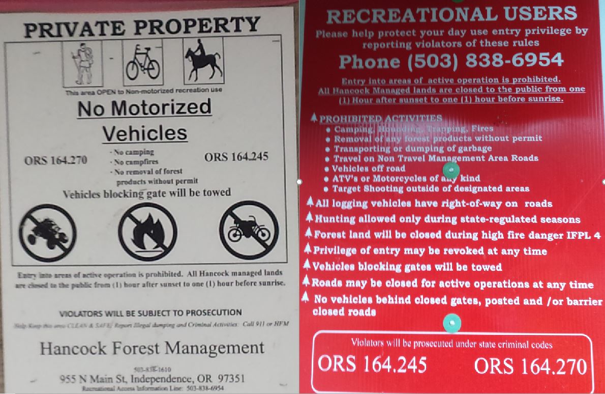


Sometimes they leave the gate open for logging traffic and contractors, even on the weekends. 


Be like Alicia, earn your turns and you too can smile knowing your toiling will go towards keeping access un-compromised for future paddlers.


NOMENCLATURE

Jason Rackley started the naming scheme on Gladiator Creek, I tried to stick to the theme he started.


Romulus and Remus: The first couple slides that start the upper run.  Romulus and Remus started Rome, which ended up being the naming theme for this upper section since gladiating occurred most famously in Rome and I ran out of applicable Gladiator terms.

Stout set of 4 drops:   Whoever runs them first can name them. 

Castrum RoadA castrum was a building, or plot of land, used by the Roman military as a fortified camp.

Triumfallades: A Roman Triumph was a huge parade sometimes given after a successful campaign that passed into the Pomerium (sacred part of Rome behind the walls).  The Triumfallades on Gladiator are a parade of big falls and cascades, passing through two pillars into a place that is as sacred a place as any to me. 

Pomerium: Meaning “behind the wall” in ancient Rome, it was a sacred open space located just past the Triumphal or Pomerium gates.  On Gladiator it is the space past the large bedrock pillars that the Triumfallades pass through, surrounded by massive rock walls and only accessible through the gate. 

The Skirmishes: A long section of continuous boulder gardens starting below the Pomerium and lasting to the middle bridge. The water was low for us during this section and while we only had one wood portage, there were plenty of other struggles navigating our loaded boats as we dodged wood, dealt with route finding, re-routing, rock-dodging, trying to stay studious about communication while keeping our eyes out for each other and downstream, along with pins, flips, traffic jamming, and deflections.


  ---


Vesuvius Falls: Mt Vesuvius was where the first battle of the third servile war (led by 3 Gladiators) happened, it is also the first notable obstacle on Middle Gladiator.  To get down the mountain the slave army had to use ingenuity to create ropes and ladders out of vines, it also takes creativity and involves ropes or a leap of faith to portage this falls.

Ludi: Games in general, and festivals involving games and parades.   These games could be private, public, or extraordinary, all things that are true of this parade of playful rapids that begin at the Rock Quarry access.

VenatorVenatores were skilled spearmen, usually pitted against carnivorous beasts.  The hole at this drop is of the carnivorous variety, then the whole paddle/spear metaphor seems to work.


---


Arena: Named by Jason Rackley and Pete Giordano, presumably because you can watch the show from the bridge.

Punisher:  Named by Jason Rackley and Pete Giordano, presumably because of the punishment this drop is capable of handing out, especially at high flows like they had.

Coliseum:  Named by Jason Rackley and Pete Giordano, presumably for the high cliffs overlooking the drop on river right.


This stream has been an ongoing project for me, and required many scouting missions and saw a number of failed attempts, these people each helped with a piece of the puzzle:  Rebecca Vogt, Sage Cruser, Tim Brink, Bruce (Ox) Reed, Pete Giordano, Jason Rackley, Rob Cruser, Dan Mccain, Ben Sigler (and his dogs), Bryan Carrington, Rick Cooley, Nate Merrill, Melissa Fowler, Rylie Coiteux, Jake Banta, Victor Repeto, Michael Freeman, Lucas Reitman, Willy Dinsdale, Ross George, Ben Mckenzie, Emile Elliot, Adam Edwards, and Joseph Hatcher.


  -jacob


Thursday, February 18, 2016

Middle Fork of the North Fork (MFNF) Trask: Barney's Playpen


Runnable levels are about 100 cfs or more coming out of Barney Reservoir, which generally only happens when the reservoir is full (1640.9').  At 100 cfs the bedrock drops are runnable and fun, but the in between is rocky. 200 cfs is a fun flow, and feels more medium in the boogie.  Be cautious about going in at higher levels if you aren't familiar with the current wood situation.

 Don't expect to get on this run early in the season as it takes awhile for the reservoir to fill up each winter. 


The run has many fun class IV rapids, both bedrock and boulder features.  Moving around on the bank is relatively easy compared to other obscure Oregon streams.


110 cfs
 Photo: Pete Giordano


There were two rapids in the mile above the confluence with Elkhorn Creek that had old growth logs requiring extra attention (still runnable and fun-ish).  The run also had a number of alders sprinkled throughout the run, but none that required portaging in Feb 2016.  Be diligent about checking for wood your first time down.  If it hasn't been run in a a couple years, there is probably going to be downed alders in the creek bed, boater-friendly beavers are responsible for keeping this run in good form.

Coming from the Willamette Valley, I have used Turner Road out of Yamhill (Blocked to the public by Weyerhaeuser in Spring 2017, then re-opened in Fall 2017).  Check with them for current accessibility, you can inquire on their recreational Facebook page.

Rules posted at the gate.


Access is also available from the coast, along the NF Trask River Rd.  This route is always available.  It is recommended that someone in your group do some rudimentary map-work before heading up there. Coming from the coast you can drive up along the Trask itself.  

Click to enlarge.

The take out (45.4656, -123.4612) for the MFNF is the same as the put in for this run.

Put in spur (45.4667, -123.4199): Drive to its end, then walk back the way you came a short ways down the road to find the access trail.  Or just schwack downhill to the creek.  This spur is at the 6 mile marker for the mainline logging road, a "6" has historically been painted on the tree adjacent to this spur.

Marker for the start of access trail.
It's not a good path, but orange flagging was there to help with finding the easiest way down.


Put in at the confluence of Coffee Creek and the MFNF Trask: 45.4629, -123.421

Thanks Pete, Nick, Joe, Jesse, Mark and Priscilla for helping suss out the particulars of this run.


-----------------------------------------------------------------------------------------------------------
Story:  Like trail building, but the trail is a creek.
-----------------------------------------------------------------------------------------------------------


Nick Hymel, Pete Giordano and I had run nearby Elkhorn Creek and found ourselves with time left over.  Pete and I decided to paddle the MFNF Trask that afternoon since it shared the same take out and we had seen water entering Elkhorn as we passed by.  I had run it once by myself a couple years before, but only remembered a few rapids and the water had been very low.  I had considered it a one time trip.

This time with a decent flow, I was surprised how enjoyable the run was.  Lots of nice ledges and class IV bedrock rapids dotted the run.  However, there were quite a lot of alders in the stream blocking lines and forcing portages.  The reservoir keeps this creek from flooding, so it doesn't get flushed out naturally like other streams of a similar size might.  Most of these trees were not in rapids, so we had a good time even with the 10 or so portages. 

A good enough time in fact that a group of boater-friendly beavers returned that year, and by the end of a long day the amount of portages had been reduced to zero.  I came back a couple more times that year, and even did a double day with Connor Dixon, not getting out of our boats on the second lap.  The next season I tried to return, but found a locked gate and the run fell off my radar.  Word is the gate is back open in 2021, but the wood has returned and no one has found the time to clear it out for boating yet.


      -jacob


Thursday, October 3, 2013

White Salmon: Middle


BETA


Stream: The Middle White Salmon is a fantastic resource near Hood River.  The river is consistently class III-III+ and consistently flowing - it is never too low to run.  At the beginning and end of the run are two rapids that are more challenging than the rest, if they are not to your liking you can put in below the first and take out above the other.


A day on the Middle White Salmon starts with a pleasant walk down a nice trail with built in rails for sliding your boat down, talk about convenience!  Near the bottom the rails bend right, while a less used trail goes left.  Going left gives you the option to put in above the class IV Maytag rapid, right leads to the option to put in part way down or below that rapid.  Maytag is easy to scout.

Watch for a cave along the right wall early on in the run, after a short bit of warm below Maytag.  At the cave rapid, paddling left of it is easy but necessary.  Once past that cave the rest of the river is read and run class III.  Everything aside from that cave rapid can be run where the water is going, a handful of the rapids stand out as more exciting than the rest but never really reach class IV until Husum.

Husum is recognized by a long flat straight-away, and a sign warning of the falls.  Most people scout this drop at the beginning of the day when running shuttle, but it can be conveniently scouted from the left and only slightly less conveniently by stopping well upstream of the falls on river right and taking another look from the Hwy bridge overlooking the drop.


Photo: Priscilla Macy                    Paddler: Alex Hymel


All the channels and all the lines have been run successfully, the middle channel is most common.  Over the years the hole has gotten a bit hungrier, and as flows rise over 3' it's not necessarily the friendly waterfall it is at the end of summer.  Scout and make the decision that is right for you.
  
Flows:  There is a foot gauge in Husum, monitored by a local who reports regularly to This Facebook Page.  And this online remote camera of the gauge.  Summer flows are between 1.5'-3.5'.  In the summer  you can ballpark flows by dividing the White Salmon @ Underwood gauge by 400 to get the level on the stick.  

This section never gets too low to have a good time on, for class III boaters ready to take the next step it is reasonable to follow someone down below 3'.  On the other end of the spectrum, if you are showing yourself down for the first time this is a reasonable rule of thumb: Over 4' be a class IV boater.  Over 5' be a class IV-V boater.  This run can handle plenty of water without getting to class V.  Husum is friendliest under 2.5'


Access:  Take out in the town of Husum, WA.  Parking is available across the street from Wet Planet Rafting.  It's worth taking a quick peak at Husum Falls from the Hwy 141 bridge in town at this point.

The put in is 4 miles upstream/North along Hwy 141 at the BZ Corner Launch Site.  Remember to take the 2 minutes to fill out your trip information at the kiosk.


----------------------------------------------------------------------------------------------------------------------------------------------

Notes
----------------------------------------------------------------------------------------------------------------------------------------------


I have found myself running the Middle White Salmon after a day on the Green Truss.  Or as a start to a trip ending on the Columbia.  Or when it is flowing in the 4-5' range, when it becomes fast flowing class III-IV wave trains with some fun features.  Or later in the summer on a lazy day, when there isn't water elsewhere.  Or when showing a newer boater down.  Husum Falls was also the first waterfall I (and many others) ever ran. The point is this is a versatile run and a resource PNW paddlers are happy to have.


Maytag @ 6'


Photo: Kory Kellum


Story:  Two of my cousins (Mitch and Braden), had been asking me to take them kayaking.  One summer things lined up, so Priscilla and I put them in duckies and took them to the Middle White Salmon.  They are of the athletic type and did well, I think they both made it through Top Drop and they stayed in their boats through all the rapids.  We spent time in the cave and ate lunch at a spot on river right I hadn't stopped at before.

When we got to Husum, I figured they would look at for awhile and we would call it a day and head for dinner.  They started asking how to run it and it became obvious they were considering it seriously.  I didn't think I was going to be able to describe to them well enough how to boof, so gave them the most useful information I could.  I told them to take a big stroke at the lip, but more importantly a big breath, and informed them it would be chaotic but the falls would let them go and they would pop up into the pool about 10 seconds later.
To my surprise this didn't deter them and off we went, both of them having predictably chaotic, but safe swims.  Popping up with smiles, we collected all the gear save one paddle and headed back towards Portland.


Husum has proven many times to be a good place (at low flows) to paddle above your comfort level and learn the power of the river in a relatively safe environment.  Yet it gets pretty serious as levels start to rise.


A personal note: I have swam out of Husum paddling a raft, hardshell and inflatable kayak.