Showing posts with label lower. Show all posts

Wednesday, April 22, 2020

Gladiator Creek

AFTER ALL THE TRIPS I DID ON THIS CREEK THE ACCESS HAS CHANGED.  BOATERS MUST NOW PURCHASE THE BLACK ROCK ACCESS PERMIT FROM WEYERHAEUSER TO RUN THE CREEK.  LAST I CHECKED A VEHICLE PERMIT WAS ABOUT $350, AND A WALK IN PERMIT WAS $75.  ANY REFERENCES TO FREE ACCESS ON THIS PAGE ARE NO LONGER CORRECT.


 Photo: Adam Edwards


Gladiator Creek is my favorite run in Oregon's Coast Range.  It's been on ongoing project for me since my first year at Western Oregon University in 2008.  This was one of a group of three creeks in the Valsetz area of the Coast Range that laid the foundation for what boating means to me, through the challenges they presented both on and off the water.  Iv'e written about the different sections of Gladiator Creek a few times on this site, but this is the page that puts them all together.  Access is both straight forward and tricky, linked below is a story from the superstars of Oregon exploratory kayaking detailing the challenges they faced paddling the lower section for the first time in the early 2000's

**ownership has since changed and there is no longer a legal barrier to running this creek.**
Photo: Priscilla Macy


It's not a typical PNW creek.  The creekbed is sandstone, and seems like something you would find on the East Coast.  Also like the East Coast, flows can rise and fall quickly.  This means the best laid plans can be laid to waste if a storm you are counting on the night before drops too little or too much precipitation overnight.  For me, the rewards have been worth the consternation.  While the 7 waterfalls stand out as highlights, it's the numerous class fun rapids between them and unique setting that keep me coming back.


After many scouting trips, failures, and a few successes on the lower few miles of Gladiator creek, the biggest piece of the puzzle was placed when Ben Mckenzie, Emile Elliott and I paddled the middle section in 2015.  We got lucky with flows and had a great time, with the highlight being perfect levels for the first descents of the ultra clean Vesuvius Falls.  Then in October 2019, a decade after first seeing this creek on a map, Ben Mckenzie, Adam Edwards, Joseph Hatcher and I ran all three sections top to bottom over a two day period with Priscilla running shuttle for us.   After years of work, and many weekends agonizing over levels and access it had finally been put together top to bottom in one push.   With the information gained on these trips, I now feel comfortable going to Gladiator any given weekend the conditions line up, with the logistics as locked in as I could ask for.
And while it's not a run for anybody, now that access is sorted out and no legal barriers are present, despite the effort required everybody who has done it has been glad they did and have been up for returning.
 Photo: Dax Kirkwood


Looking back on the influence this creek has had on my thoughts and decisions over the years, I don't think any other stream has defined kayaking for me more than Gladiator has.  Each time I paddle the creek, I leave thinking there is not another stream in Oregon I feel more entwined with than this one.
Photo: Priscilla Macy


Below are links to descriptions for what you can find on each of the three sections of this creek.


This is the most adventurous section, and if you want to give the big drops a real look, plan on doing this section over two days.


MIDDLE  (3 miles)
IV-V
This section is a contender for the best day of creek-boating you can get in Oregon.


LOWER  (4 miles)
III(IV,V)
While there are only 3 notable rapids, they are 3 of the more unique and enjoyable rapids in the state.


Lastly, the part I paddle most often, with the most bang for your buck.


IV-IV+
This run begins part way through the Middle section (below Vesuvius Falls) and gives a good option for those not interested in Vesuvius Falls.  This is the section I'll do any given day, there is plenty of class fun whitewater without the commitment of what is found upstream.  It starts 1.5 miles above the Lower put in bridge.


FLOWS:  The gauge is located at the only place the creek runs along the highway, the creek is visible here through the vegetation if you are looking for it.  This proximity occurs just as you are entering a small town if coming from the east.   There is a guard-rail there, and if you park on the west side of the guard rail (across from the liquor store) you can walk back to the east 75 feet to where some yellow paint is splashed on one of the posts supporting the guard-rail, marking the point along the guard-rail closest to the gauge.  The gauge is just a few wooden shims with numbers on them, glued onto a rock.  It's behind a couple trees adjacent to that yellow paint and about 20 yards upstream of the small riverwide ledge/hole/wave (depending on flow) visible in the photo below.

The visual gauge on Gladiator Creek, and what you might be able to expect based on an approximate correlation to the flow in the Salmon River below Slick Rock Creek Gauge.


Data points


There is more information on each of the section pages about how flows pertain specifically to that section.  There is also more detail and the opportunity to nerd out on this other page where I keep notes on historic flows and jot further notes on levels.


ACCESS:   As of 2020 the private logging company who owns all the land the creek runs through allows walk in access.  Access is detailed on each individual page.


 I have stuck with the moniker given to the creek by Oregonkayaking.net, who were paddling the creek under the radar on the first descent of the lower section.  While the access situation is improving, and currently there is no red-tape or legal barriers to hiking in and paddling the creek, leaving the name off the internet seems like a good way to keep that status quo.  Along that same vein Iv'e always tried to keep a low profile when hiking into and paddling the creek, but smiling at anyone working back there and think that mentality will go a long way towards keeping access from being barred to future paddlers.  I have left enough information about how to access the different sections on their individual pages (linked above) and this one that someone who has the wherewithal necessary to paddle a creek like this will be able to sort it out just fine.  If after all that you think you have the logistics sorted, but end up failing at your attempt and leave this Rock un-turned, you could always give your luck another try at the nearby casino.

 Photo Emile Elliott


While there was a time that driving to the put in was allowed on weekends during hunting season, public vehicle access has since been barred.  This has come at the gain of the public being allowed to hike into the creek on nice gravel roads any day when the fire danger is not high, though I try to stick to the weekends to keep from getting in the way of daily operations or getting skunked if they are blocking the road.   I personally prefer the new situation to the old, given how uncommon it was for this creek to run at a good flow on a weekend during hunting season.  While the hiking is straight forward, the distance is not short (3-6 miles depending on the access point and section).  I typically use these, but a variety of carrying systems have been deployed, even the old shoulder.

Does smiling with a kayak strapped to your back count as a lie?
Photo: Dax Kirkwood


RULES


There are some rules to be followed if you plan to kayak this creek.

Follow this link to zoom in on the map and bullet points(zoomed to in second graphic).  The areas inside the green on the map are open to walk in access.  As of 2020 the Gladiator Creek watershed is entirely within the green area. You can double check the kiosk near the bottom gate before starting your hike for updates.


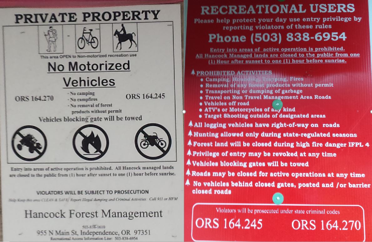


Sometimes they leave the gate open for logging traffic and contractors, even on the weekends. 


Be like Alicia, earn your turns and you too can smile knowing your toiling will go towards keeping access un-compromised for future paddlers.


NOMENCLATURE

Jason Rackley started the naming scheme on Gladiator Creek, I tried to stick to the theme he started.


Romulus and Remus: The first couple slides that start the upper run.  Romulus and Remus started Rome, which ended up being the naming theme for this upper section since gladiating occurred most famously in Rome and I ran out of applicable Gladiator terms.

Stout set of 4 drops:   Whoever runs them first can name them. 

Castrum RoadA castrum was a building, or plot of land, used by the Roman military as a fortified camp.

Triumfallades: A Roman Triumph was a huge parade sometimes given after a successful campaign that passed into the Pomerium (sacred part of Rome behind the walls).  The Triumfallades on Gladiator are a parade of big falls and cascades, passing through two pillars into a place that is as sacred a place as any to me. 

Pomerium: Meaning “behind the wall” in ancient Rome, it was a sacred open space located just past the Triumphal or Pomerium gates.  On Gladiator it is the space past the large bedrock pillars that the Triumfallades pass through, surrounded by massive rock walls and only accessible through the gate. 

The Skirmishes: A long section of continuous boulder gardens starting below the Pomerium and lasting to the middle bridge. The water was low for us during this section and while we only had one wood portage, there were plenty of other struggles navigating our loaded boats as we dodged wood, dealt with route finding, re-routing, rock-dodging, trying to stay studious about communication while keeping our eyes out for each other and downstream, along with pins, flips, traffic jamming, and deflections.


  ---


Vesuvius Falls: Mt Vesuvius was where the first battle of the third servile war (led by 3 Gladiators) happened, it is also the first notable obstacle on Middle Gladiator.  To get down the mountain the slave army had to use ingenuity to create ropes and ladders out of vines, it also takes creativity and involves ropes or a leap of faith to portage this falls.

Ludi: Games in general, and festivals involving games and parades.   These games could be private, public, or extraordinary, all things that are true of this parade of playful rapids that begin at the Rock Quarry access.

VenatorVenatores were skilled spearmen, usually pitted against carnivorous beasts.  The hole at this drop is of the carnivorous variety, then the whole paddle/spear metaphor seems to work.


---


Arena: Named by Jason Rackley and Pete Giordano, presumably because you can watch the show from the bridge.

Punisher:  Named by Jason Rackley and Pete Giordano, presumably because of the punishment this drop is capable of handing out, especially at high flows like they had.

Coliseum:  Named by Jason Rackley and Pete Giordano, presumably for the high cliffs overlooking the drop on river right.


This stream has been an ongoing project for me, and required many scouting missions and saw a number of failed attempts, these people each helped with a piece of the puzzle:  Rebecca Vogt, Sage Cruser, Tim Brink, Bruce (Ox) Reed, Pete Giordano, Jason Rackley, Rob Cruser, Dan Mccain, Ben Sigler (and his dogs), Bryan Carrington, Rick Cooley, Nate Merrill, Melissa Fowler, Rylie Coiteux, Jake Banta, Victor Repeto, Michael Freeman, Lucas Reitman, Willy Dinsdale, Ross George, Ben Mckenzie, Emile Elliot, Adam Edwards, and Joseph Hatcher.


  -jacob


Thursday, November 21, 2013

Pure Joy Amongst Pure Hate

The Pure Hate Gorge on Quartzville Creek has a write up on Oregonkayaking that has kept anyone I knew of away.

I had never been particularly interested in the run until Lucas Glick and I were riding on a speedboat with kayaks in tow across Green Peter Reservoir.  We had just paddled off the Middle Santiam Wilderness run and found we were going to get to our cars with plenty of light left.  Conversation with the kind locals quickly died out as nothing but the most basic of pleasantries was possible with the noise of the wind.  I began brainstorming and I thought that Pure Hate was nearby, short, and would be low.  Maybe we should check it out?

Lucas is not hard to convince when it comes to trying new things in a kayak so once we reached the take out and had our gear packed we headed up the Quartzville rd.

 The put in was easy enough to find, a quick walk to the river and we were on our way.  There were a couple small bedrock rapids and some wood before a 6' ledge.  Below here things kicked off.  First was a slide with wood.  Then the creek turned the corner and dropped through some serious whitewater.  The first two rapids had us pretty worried and a downstream view showed another corner in a locked in gorge.  With less than an hour of daylight left we hiked out, deciding to potentially return the next day.

We stayed at the Glick's house in Sweet Home, where we were treated to some cooked food by Lucas's mother.  I was tired after the long day on the Middle Santiam and by the time I fell asleep I had written off boating the next day and Lucas bailed on the Clear Fork.  Lucas came into the guest room in the morning and asked if I wanted to head back into Pure Hate.  I thought about it for a few seconds, but knew I couldn't turn down a chance to see what was in the gorge and before long Lucas Reitman had showed up at the house ready for adventure. While making breakfast we looked at some canyoneering reports and the satellite imagery, by mid-morning we felt we knew mostly what we were in for.

We put on to slightly less water than the day before but still acceptable exploratory flows.  Again we paddled our way down to the gnarly rapids at the head of the gorge, this time though the Lucas's were fired up to run the near mandatory one and I decided to force a portage route, while also trying to set some sort of safety.

Glick went first and came through with nary a wobble.
Lucas Glick drops into "Fear and Loathing", a two drop rapid with a tricky ledge into a pothole that is just out of sight in this photo.

 Lucas Reitman also cleaned it.  I scrambled around to a point where I could do a throw and go, and took advantage of the low water to take a peak around the next corner, which turned out to be a fun rapid the Lucas's ran on verbal beta.

A great place to be.

Below Fear and Loathing the rapids were pretty locked in but not harder than class IV.

There was one logjam that required a seal launch.

We ate lunch at a neat side hike with a waterfall.

Once the gorge opens up there are a few more rapids worth scouting.  All the rapids below Fear and Loathing either had a clear line or we were able to portage at low water.

One of the last rapids.

After a slide comes in on the right (it doesn't go as clean as it may look) we were in the runout and the bridge came not much later.

We were stoked on the run and were already planning our next trip to this cool gorge on the drive home. It is very similar to Opal Gorge and Elk Lake Gorge in that it feels like a class five trip, but aside from the entry rapid (Fear and Loathing and its predecessor) it is manageable for adventurous boaters at low water.

Our best guess was that good levels for this run are between 500-1000 cfs on the Quartzville gauge from snowmelt.  In the winter when the stream is fed from rain, the gauge reference here may become obsolete.

The take out for this run is the put in for Upper Quartzville:  44.5806, -122.2454

You can put in as high as this bridge:  44.5845, -122.193

The gorge starts here, so if you don't want any warm up you can find a place to scramble down from the road between the bridge above and this point:  44.584, -122.2282

  -jacob

Thursday, December 20, 2012

Silver Creek (Silverton)


This run was always on the back of my mind being close to school, but I had never gone for it thinking it was a big mission so as such it was on a large list near the bottom.  I may have been reading between lines that weren't there in the existing literature, but I was under any Winter trip to Silver Creek would be a fight against darkness.  Fresh off a different big mission and a sore hind quarters from a bad line off Cascada De Los Ninos Nate and I decided we were just fine with a moderate mission.  John Edwards thought that sounded like a good time too, Silver seemed the ticket and levels were there so went for it.

Kayaking was banned in the park at some point, but AW is in talks with State Parks to see if an agreement could be reached that would allow kayaking.  Stay tuned.  


We didn't see anyone else up there, maybe it was a weekday or something.  I don't recall.


The levels were not as high as we expected, more of a healthy-low.  The snow put us in a good mood as we walked and dragged our boats down the trail. 

 We may or may not have run Drake Falls, which may or may not be the funnest 20 footer around.  This drop no longer has wood in it.  Twin and Lower North were definitely wood riddled as of 2012.  


If you really want it there is a line.


Once we reached the confluence there was an easy slide or two before reaching Crag Falls.  We ran this on the right, the best line being as close to the tree as you are comfortable, too far to the right of the tree and you may find a chest level rock in the landing.

There was some tame water below here with some moderate scenery.  Eventually we caught the easy eddy on the left above Dobo Falls.  Dobo is a weird falls that saw three upright lines, but lets just say I’m glad the camera wasn't recording my descent.  

Nate gets it done.


Just below was a ledge we ran on the right with a more interesting looking line on the left.

Following that was a lengthy class two stretch before Dirty Falls that has a slide on the right that is smoother than it appears from the lip.


There was a bridge with a slide best run center left below here, then another extended class two float to Murrays Rapid.  This one had a sticky hole, and we were a bit lethargic after nodding off through the easy section and all snuck the hole either left or right.  


John takes a lefty on the right.


 This was the last drop and we were soon on the reservoir, with the take out on the far side.


Silver Creek may have a unique appeal:  John pointed out this would be a good run to take a newer boater.  Someone would need to be able to catch eddies and have some form of a roll, but there is a lot of good class two on the run to practice on with a variety of different types of the easy variety rapids, with a couple more interesting drops for the teacher to have fun on and introduce the newer boater to some of the more advanced techniques involved in kayaking (larger drops are easily portaged).  The most challenging moment would be Dirty falls where a wave hole guards the river right eddy.  A further up eddy can be caught before the lead in though.


3000 cfs on the Molalla seemed low and friendly, but the run would be floatable down to 2000-ish.  Also, while the run is 11 miles, we were on the water less than 4 hours.

I now use the Butte @ Monitor gauge for Silver Creek, I don't have it dialed but 400 cfs is a low runnable, and 1,000 is probably a filled in and padded med-high flow. 

It can also be run at flood level.


    -Jacob

post script:  There is a clean 50 footer above the put in that gets run.

Monday, January 30, 2012

Canyon Creek, Oregon

Darren Dangerdeeds likes Canyon Creek, OR.


BETA

Stream: This is a benchmark run in the Willamette Valley.  Once considered a classic run, a landslide into Day of Judgement (the largest rapid of the run and one of the best in Oregon) rendered that drop a mess and changed the dynamic of the run.  

The run is still good, but feels like more of an adventure run than a classic nowadays.  The first two miles after the boulder-bar beginning are steep and can easily take twice as long as the lower 5 miles.  Reading and running is not a good technique on the Upper section.  If it's your first time, my recommendation would be to catch all the eddies and scout all the rapids until you are past Black Creek. 

Below the bridge at the put in, boulder bar floating eases you into the day.  There is some wood to dodge, and the last few times Iv'e done the run Iv'e done one easy portage up here.  As the river consolidates (you can use a scrambling put in here to avoid the boulder floating at the beginning), the first rapid is quickly reached.  A bouldery lead in turns into bedrock at Chocolate Chips, scout right before entering the small boulder garden.

Josh Roach, Chocolate Chips.
 Photo: Thomas Imes


Downstream is another boulder garden leading into Chicken Little, which has some small scouting eddies on the left.  This rapid can collect wood.  It is easiest to scout left, but a partial portage on the right into a sneak line is what I have done when wood blocks the main line.  Eddies are not always generous on this run, so take a good look for them before committing to any moves.


After Chicken Little, getright against a wall to scout the next straight-away that ends in an eddy on the left that should be caught before the river disappears into some boulders.  Scout from this eddy, and most likely make a strong ferry back to the right to the line you picked out.

More good rapids continue downstream, even though they can be read and run, I recommend scouting everything on this run your first time down.


1-2 rapids later there has been a logjam extending from the left bank, with one log reaching all the way to the right bank.  There is a last chance eddy above it on the right, with a bugger rock to mind.  Sometimes we have been able to sneak by or over the log, sometimes we have to portage.  

Good rapids continue below the portage, including this great boof.

The boof is an important marker, because just downstream is Demon Seed, a rapid that looks like it may be read-and-run, but is actually a portage for most people.  Demon Seed looks like a mini-BZ Falls, but flows under the right wall.  Of the people I have seen run this drop, most go under the right wall, but have always flushed quickly.  I don't fancy the thought of being under the wall so have always made the quick portage on the right.


The whitewater opens up downstream, becoming read and run for awhile.  This changes when the stream bends right at a small gravel bar with the road visible downstream, high on the right.  Scout Terminator from this gravel bar.  Terminator deserves respect and safety is a good idea.  There is a sieve on river left that is mostly, but not entirely out of play.  The pocket on the right is more in play, though good safety can be set here.  An ideal line threads between the rock in the center that divides the flow and that right pocket.


Just downstream is a big ledge, before the river drops around a room-sized rock and enters Day of Judgement.  Day of Judgement was once considered one of the best rapids in Oregon, but a landslide that occurred before I ever ran the creek changed the rapid forever.  My first time down, the Dinsdales and I ran a sneak channel to the left of the big rock.  Iv'e chosen to take the sloppy portage on the right each time since.  The middle line has been run, with poor results.  Day of Judgement does change every year, and we keep hoping some day it will return to a worthwhile rapid.  Portaging on the right is better than the left, but still requires concentration as it's on a steep scree-field.  


The boulder garden downstream ends in a rapid that looks heinous from above, with logs sticking up vertically but actually is pretty easy compared to most of the rapids encountered so far.  Every time I have run the creek, driving left of the logs has been hunky-dory, though I do like to boat scout from a tricky eddy on the right just before the horizon to make sure things haven't changed.

On a low water trip, the right channel looked better.

A rapid or two are between here and Black Creek, which enters down a tumbling cascade on the right, which must be forded to scout the next ledge.  The line on this ledge changes with water levels, so it's worth a look.


Just around the corner it looks like there is a big wood hazard, but as of 2019 it is safe to read and run through the right channel to an eddy on the right, from which you can see there is a clean line.

Fun class IV continues as you enter the Lower section.  There are two rapids to look out for on this lower stretch, and paddlers need to keep an eye out for both to prevent accidentally running them.  


After the initial set of fun rapids on the lower section, there is a lull.  Keep an eye out near the end of this lull for brushy banks and large boulders visible downstream.  If you see those boulders, quickly make your way to the right bank, into a small channel to the right of a brush bar to scout Osprey, one of the biggest rapids on Canyon Creek.  It is important to make it into that tiny right channel to scout, or you will be forced to run this common portage blind.


The next notable ledge downstream looks like it can be run anywhere from above, but in reality needs to be run left at most levels.  Branches sometimes complicates this.  Things maintain a quality class IV nature downstream of here, interspersed with sections of easy and often scenic floating.


The next notable rapid comes at the end of a class II straight away, ending in what looks like a small pinch/ledge.  Eddy out right here to scout the Constrictor, another common portage.  While the drop is small, many people make the easy portage on the right.


More fun rapids continue, along with some more easy floating.  There is a beautiful gorge down in this lower section, and some more good rapids.  This gorge tends to collect wood, but usually nothing requiring a portage, stay vigilant.


One of the cruxes of the run is actually catching the take out eddy under the bridge.  It is pretty small, so if too many people try to catch it at once, it would be possible for someone to get blown downstream.  If that happens, getting out becomes more difficult as vertical walls make it difficult to exit the creek.  This eddy can be scouted from the take out bridge while setting shuttle.


If there is time, a lower take out can be used at Cascadia State Park.  This allows paddlers to pass the normal take out and float into the South Santiam, where it passes through one of the more scenic gorges in the state.  There are not any notable rapids, so it provides an opportunity to soak it in.


If you are doing the full run, keep in mind this is a 7 mile run and the upper two miles are not conducive to boat scouting.  Moving with urgency will keep you from dealing with a setting sun.


Flows:  300-700 on Pat Welches estimate is good for a first time go if flows are not rising.

Here is a photo from the Hwy 20 bridge at minimally fun levels for the lower section, I wouldn't think the upper would be worthwhile at this level.


AccessTake I-5 to Highway 20 and head east.  After passing through the town of Sweet Home it's about 16 miles to the bridge over Canyon Creek at the take out.  44.396770, -122.447861

A gravel road takes off to the right just after the bridge and heads up to the put in.  There are 3 put in options, located at these mileages past the turn off from Highway 20:

4.9 miles (44.361064, -122.382634):  A steep trail leads down to the creek here at the bridge over Black Gate.  This is considered the lower put in and skips the two miles of challenging creek boating above.  It is a great intermediate run by itself, and is a nice intro to creeking sort of run.  It is also possible to hike in at the base of Day of Judgement, to add a couple IV-IV+ rapids to the lower run.

6.6 miles (44.341517, -122.365220):  If you want to get right into it, you can schwack down to the creek from one of the pull-outs either 100 yards upstream or downstream of this point.

7.1 miles (44.333839, -122.361907):  Turn right and the road quickly leads to a bridge.  This is the put in I like best.  It gives you about 15-20 minutes of open floating through boulder bars before the first rapid.  I have always had exactly one easy wood portage when I have put in up at this bridge.


----------------------------------------------------------------------------------------------------------------------------------------------
Original Write-up
----------------------------------------------------------------------------------------------------------------------------------------------


Our first time down,


    As told by Andrew Bradley


Nate, Jacob and I had been talking about what we should do for this up coming weekend. Flows in the Portland area were not looking super promising so Nate and I packed up shop and headed to Corvallis for the weekend. Saturday morning flows were looking great on Canyon Creek.  There is a general consensus that the creek gets pushy over 500 cfs so we were anxious about what it would feel like.  The gauge showed ~600, but Rick had run the creek at 650 on the gauge and said this felt higher.  We surmised the estimated gauge is different based on a rising vs. falling stream (we had a falling level).

       Our main concerns with the creek at this level was new wood from the ice storm that had come through the North West Region the previous week and the rumors of abundant undercuts due to the unstable geology. Rick and Dan lead us to a put in just above Chocolate Chips that avoids the mile of wood and flat water above, its exciting starting the day off with a class five!  The rapid starts off with a small boulder garden that progresses into a series of small ledges where the water is eventually funneled into 7ft wide crack.  The first 3 boaters flipped, and the last 3 stayed dry.  Moving into the next series of rapids is a pushy technical boulder garden that is leading into Chicken Little. This rapid looks ugly but go's pretty smooth; there is one massive old growth that looks like it has been stuck in the rapid for a while but is easily avoidable.  It can be portaged.

 Brian Butcher, feeling it.
 Photo: Lucas Rietmann

 After finishing the crux part of the drop the river is split into two channels for about 200yards.  Both channels are currently clear of wood.  As the channels regroup the creek rips into a technical boulder garden that is quite long and fun.  The last horizon needs to be run on the right (easier said than done).  At this level a couple of us were able to cut right from the left channel which worked, but is not the preferred line. The left half of the river pours into a nasty sieve with a root wad stuck in the middle.

       Next up was a ledge drop that was reminicent of sacriledge on the the little white. Big hole and all. A few more boulder gardens and a flume found us scouting Stuff Sack, more commonly known as Demon Seed. Three people ran stuff sack on this day.  This drop has a very clear line and a very clear undercut pocket on the right. Terminator is the next significant rapid followed by Day of Judgement, both of which you can scout from the road as you drive up to do the upper section. Terminator, which is known for the nasty sieve on river left, is cleaner than I had imagined, but still possesses significant consequences for a blown line. Both the aforementioned seive and pocket on the right side complicate things. There is a sneak on the left for Day of Judgment at the flows we had that starts off very manky and ends in a clean 8ft ledge.  

  Photo: Lucas Rietmann

          The section imediately below Day of Judgment should be approached with caution. It is the only section on Canyon Creek that cannot be scouted and is un-portageable. It is  important that after committing to the lead-in, you catch the large eddy on river right just after to gorge walls close in. From this eddie, you can boat scout the crux section (Jacob was able to hop out and get a visual, but that option may not exist at lower flows). The entire right side of the river charges beneath an old growth log and then flows into an undercut. The left side of the river is very manky and contains several rocks that could pin a boat. The line is the cut just above and to the left of the old growth root wad in the center of the river.  If you run this thing correctly, the spray from the water hitting the root wad will actually envelope you as you drop through the narrow channel. Although this drop isn't too difficult, it is one of the more consequential rapids on Canyon Creek.    Below this gorge, the run then alternates between large ledges and flatwater. Before you reach the put-in for the lower section, there is one giant ledge hole to be aware of. On this day, two of our group went for a ride, but were able to escape.  

It is common for boaters to just run this lower section (class IV), however the first ledge of the lower section held a swimmer for about a minute on this day, so be sure you have a solid boof before attempting the run, especially at this level.  Watch out for Osprey after the first mile or so of flat water, it would be easy to mistakenly enter this rapid. Dry out in the brush on the right to scout, if you see large boulders downstream it might already be too late, get into the right channel and paddle hard. The run over all is generally clean and definitely worth doing.  

Keep an eye out for Constrictor as well, a small/narrow 3' drop at the end of a class II straight away with a vicious hole that is typically portaged on the right.

A special thanks to Dan Rubado and Rick Cooley for showing us the lines, we would have been in the dark without you guys (literally). 


Canyon Creek, OR from Andrew Bradley on Vimeo.

-Andrew