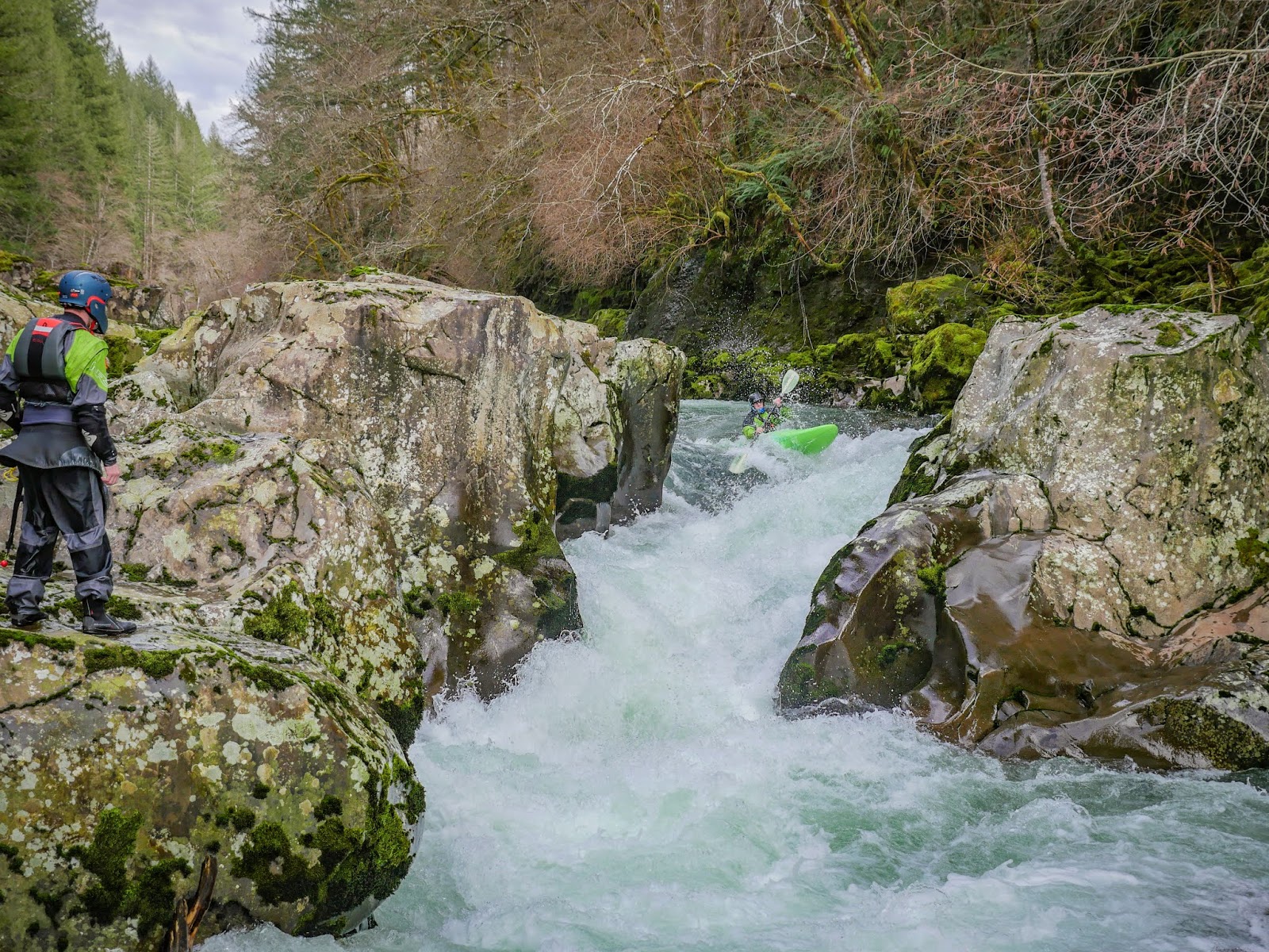
Showing posts with label east fork. Show all posts

Thursday, July 6, 2017

East Fork Eagle Creek (Wallowa's)


 Photo: Michael Freeman

Michael Freeman and I checked this out in the Spring of 2013.

We hiked 6 miles to this point 45.1404, -117.3032, camped, then hiked up and scouted some more.

Camping in a drizzle.
 Photo: Michael Freeman


We didn't find anything we wanted to run that high up so returned to a meadow and floated down from there.  If I went back I'd put in here: 45.0869, -117.3067 where a 2.5 mile hike puts you in right at the top of the worthwhile whitewater.

To get there, drive to the East Eagle Trailhead.  Hike the trail on river left a little under 2.5 miles.  The spot to put in is notable:  For one, it is where the trail crosses over Curtis Creek.  Second, there will be another small tributary sliding down the mountainside into East Eagle from the other side of the creek.  Finally, there will be a large class V-VI rapid on East Eagle.  Scramble down to the creek and put in just below this rapid, which pinches down and drops 20+ feet.

Right around the corner the creek narrows, you won't have far to go before you will want to scout a  triple cascade.  There was an unfortunate log in the final tier when we were there in 2013 so we portaged the set on the left via the trail.

 Returning to the creek via a short glissade.
Photo: Michael Freeman


Downstream was a fun section of whitewater with a handful of unique bedrock rapids in the class IV-V range.

 Photo: Michael Freeman

Below the bedrock the creek looses character and runs through boulder channels that appear to change year to year.  The creek still has gradient so it kept us focused and we had a good time splashing down it.  We had one short log portage in this section in 2014.

At the very end was a bridge that had been destroyed by high water, we floated over it but its definitely worth a scout at the beginning of the day on your way up.

If you wanted a long day of boating you could combine this section with the main stem of Eagle Creek.


We had 940 cfs on the Eagle Creek Nr New Bridge gauge (which can be found here).


The Imnaha gauge was also fluctuating between 1200 and 1400 cfs from snowmelt when we ran the EF of Eagle Creek.


Click to enlarge map


    -jacob


Thursday, November 1, 2012

EF Rock Creek: The Rock

all photos by Emile Elliot unless otherwise marked.

  This run has a rave review on Oregonkayaking and I had heard promising things from others who had tried to run the creek.  We had some water this weekend and decided to finally see "The Rock" for ourselves.  Access is pretty easy following the description on Oregonkayaking, the only tricky part for us was locating the take out trail, but Alex saved us from getting skunked (for now) by spotting it on our way out.  We put in at the bridge and dealt with a handful of log portages and a hornets nest that found Alex's neck and Nate's hip.  Alex hiked out at this point, a few more portages later Nate joined him.  Emile and I got to the falls and found a really clean, fun looking drop with some sketchy logs in the outflow.  We decided to wait for the logs to evacuate the pool before returning and running this drop.  We hiked to the road to communicate with Nate and Alex and decided to continue on regardless of the likelihood of a torture fest.  We portaged two parts of Sluice box due to wood, but the parts we ran were fun.

 The sequence of myself running the bottom of Sluice Box. 


 The bedrock drops we ran that lacked wood were fun in a unique kind of way.  They were very low consequence that were run right down the middle.  Just sort of paddle to the top and then enjoy!  Unfortunately, most of the drops had wood and there were times I felt we were just walking along the creek until we saw a drop we could run, running it, then resuming our never-ending trudge along the bank.  By the time we got to Damage Inc we were more than over the creek, but there was still lots of work to be done so we did it.  It was nice to see the take out.

The altered, then altered again Damage Inc.           


 Getting back in below.


This run would be totally worth doing if it lacked wood like back when the Oregonkayaking team was running it, I really liked the style of the drops.  Unfortunately it is unlikely this run will ever return to form without some help.  I wouldn't be surprised if there were over 100 pieces of wood in the stream contributing to a portage with many more on the banks waiting their turn.  As is, the park and huck of the falls is likely all that is left of a past gem.

Ghris Gabrielli launches big off Nutcracker!
photo EJ Etherington


Flows:

The gauge mentioned on Oregonkayaking has been discontinued.  Thomas is close by though so here is the flows on Thomas on days the EF Rock Creek has been run. Shooting for 1,000 cfs or more in Thomas Creek seems to be a good bet.


 This is the flow we had, on October 28, 2012. I'd go back again at the same level.


These are the flows OregonKayaking had.


Compare below the same days on Rock Creek (from the OK trip report) and Thomas gauges.


The Shafer creek Near Lacomb gauge is also a gauge on note.  It's a little further away, but the size of the stream is similar to EF Rock and has same elevation, even the same drainage shape.  50-100 cfs is probably the medium range to shoot for on that gauge.  The OK guys ran it at 100 cfs dropping to 50 cfs on that gauge and flows were good, then again at 70-60 and had good flows.  We had 90-60 cfs and it was in.


           -Jacob

Monday, January 30, 2012

Flood Fun


                                        Photos by Aqualegia Leet, Priscilla and myself

PNW got hit with huge water January 2012.  We had gone from no water to a state of emergency in nearby counties.  Finding a river to run seemed just as hard as with no water unless you were willing to playboat as all creeks were too high.    I ended up not trying to force anything and day one just scouted the local falls near our school that has yet to be run.

Still looked pretty ugly, the recycle at the bottom being the main concern.  Maybe it will get run at some point, but I won't be the one to do it.

Update: Not true


A year later I came back and decided it would be fun to seal launch in to the pool from the summertime jumping point at night.  Similar levels made for a soft landing.


The next day I went for a nice paddle with a fellow Earth Science student through Helmick State Park.  The Luckiamute had gotten absurdly high and we were paddling on the road that is usually 20' above the stream.


                           Jan 20, 2012                                                                         Fall 2016

 Jan 20, 2012      

      Fall 2016

 It was easy to paddle from the park into the river, so I paddled to the top of the park, peeled out into the river and road the 15,000 cfs of flatwater to the end of the park (the river was at 30,000 cfs the day before).


Mid channel.  

I paddled under the bridge which is usually 25 ' above the river and tapped it with my paddle.

Jan 20, 2012                                                                         Fall 2016

I then came back up and eddied out behind this tree.  The current was really moving through the park, you can see this here.

Jan 20, 2012                                                                         Fall 2016


 There were some conveniently placed steps at the gauging station that I used to get out.

Jan 20, 2012                                                                         Fall 2016


The next day I woke up really late and some of my friends decided to join me as we looked for a "secret waterfall".  I had little hope of the drop being runnable because the landing was only a couple feet deep in the summer when I had last scouted it.  We got there and kept on the down low as we crossed a field and got our first glimpse at Shivley Falls on the East Fork of Drift Creek.  It had a ton of water and I excitedly headed down to check it out from water level.  The drop is a two tiered, 30 foot drop with the top drop landing directly on the bedrock creating the second tier (no go).  I had hopes the second tier would be do-able.

I took a trip behind the falls to the other side and decided I would run the lower tier.

Walking over to check out the options.
Patrick Stephenson photo.

 We went back to the car and I geared up, going over all the things my team needed to know to keep me safe.  The big concerns were the 2 ft' deep landing and the lack of eddies to take out in before the stream crashed into some river-wide bushes.

I carried my boat behind the falls and set up next to the base of the first falls, Pat would push me directly through the edge of the first curtain and into the second drop.

The landing of the first falls, and the lip of the second.
Patrick Stephenson photo.


All went according to plan and I was able to execute the line I had planned in my mind,  upon landing I drove across the current towards the right bank where I grabbed onto a tree while Aqua grabbed my boat and I jumped out, stoked on such an impromptu and fruitful adventure.  All said and done we were there less than an hour before we were headed back to Monmouth for a birthday celebration.

My friend who was holding the camera was nervous and forgot to take pictures of me running the drop, and this blurry shot is the only picture we got of the entire falls.  The bottom tier is 10-15' tall.


Thanks to the team from WOU for coming and setting safety!

Butte Creek needs to be over 1,000 cfs before this drop becomes "runnable".

   -Jacob

Friday, June 25, 2010

East Fork Hood, Upper and Middle

Beta

You can find beta for the Upper East Fork Hood here.  The beta here is for the less desirable middle section of the East Fork Hood.

Stream:   This isn't a great run, but in a year without wood issues it could be considered worth doing. It begins at the take out for the Upper section and is fairly continuous class II-III all the way into Dee.  If you continue that far be cautious of some old dams just above the take out that could be tricky at high flows.  There is also a water intake at some point along the run to avoid.  Mostly it's just quickly moving water and try to make sure you don't go around a blind section that has wood hiding downstream.   I wouldn't call this section a portage-fest, but we probably walked 3-5 wood hazards.

Flows:  We had 3.8' on the Hood Gauge from snowmelt when I did this stretch.  For any section of the East Fork Hood I usually look for about 4' with a noticeable diurnal on the Hood gauge and will go down to 3.5' sometimes.  5' from snowmelt is better, and it can be run even higher but I hear it gets fast over 6'.  If it's running from rain I don't have any flow advice, Iv'e never run the EF Hood except from snowmelt.

There is a new estimate from Pat Welch for the East Fork.  I look for a diurnal of at least 50-100 cfs on that gauge.  It has been run with that gauge reading 300-1,000 cfs with little difference, so going off the diurnal seems to be the best bet.

Access:  Take Hwy 281 out of Hood River to the town of Dee.  A bridge crosses the stream in what used to be the middle of a town.  This is the take out.

The put in is accessed by continuing upstream on Hwy 281 to where it intersects Hwy 35 in the town of Mt. Hood.  Turn right onto Hwy 35, in a little over 5 miles you cross the East Fork Hood and that is the put in for the middle section.

------------------------------------------------------------------------
Original write-up
------------------------------------------------------------------------

all photos by Tim Brink of ORT
With water levels starting to hit the summer flows, it was time to start heading back to the go to runs. Usually this means the Truss and Little White. I usually try to stay off these runs as much as possible during the winter, knowing they will have water long after everything else dries up.  With this thought in mind, it was easy to be corralled to the other side of the Columbia and into the Hood River Drainage.

Day one was the Upper East Fork Hood, which Tim wrote up on the ORT blog http://www.oregonraftingteam.com/ .
I enjoyed the run and appreciated the extra flow from the last time I had been here. There was not a single pool on this run.
We put in a Sherwood campground, dodged a couple trees, ran a fun sliding ledge, then boogied down to the worm.
The author running the sliding ledge.
The worm was pretty fun, fairly trivial at this level still, but fun.

Here I am just below The Worm entering the best section of the river.


Then the river kept going for about a half mile of very fun class IV whitewater that tapered off to III-IV and a wood hazard or two.  Tim and Jeff from ORT had a good time in the Puma, so if you want to take a small raft down this section, it's possible.

We then continued down the middle section of the EF, which was all class II-III with a couple wood portages. At least we got to see a new section of river.

The author finishing up the middle section near the diversion canal. Not a hard move, but don't go the wrong way!


The East Fork is boatable down to 3.5 on the Hood gauge at Tucker. We had 3.8 ft for this trip.

-Jacob

Monday, February 15, 2010

EF Lewis River


Photo: Priscilla Macy


BETA
 3.5,  5.5,  8,  or 11 miles


Stream: The EF Lewis is a fantastic intermediate stream near Battleground, WA.  Don't come here for a constant barrage of whitewater though, for that head to Canyon Creek where you get more bang for your buck.  That said, I like the EF Lewis run better.  It's longer, and if you accept that you will have a lot of easy floating between rapids, you will be rewarded to a lot of good rapids and a great day on the water.   Higher flows makes the boogie go by faster, which can be tedious at low flows, and spices up all the rapids.  

Sunset Falls is easy to lap and has a few different lines, so makes a nice way to start the day. 

Photo: Priscilla Macy


 When you get your fill here just peal off downstream and warm up for some rapids in the class II boogie.  The first notable rapid comes on a right bend with a rip-rapped road visible on the left just above the turn.  This is Hippie John's and is best run to the left of a large mid-stream rock that can be seen from the top of the rapid.

A short class III rapid ends in some fast water above Skypilot, my favorite rapid of the Race Course section, the most common line is down the left.  A quick moment of bouldery class II leads to the gorge.  The gorge starts of with Screaming Left, followed quickly by Dragon's Back.  Both of these can be scouted from the left before entering the gorge.

The red boat is exiting Screaming Left, and the Blue boat is entering Dragon's back.  There are paddlers visible on shore where the scouting happens.  At lower flows there is a pool between these two rapids.
Photo: Priscilla Macy


Dragon's Back empties into a class III rapid that ends in a pinch point that often has logs broached between the walls.  Typically these logs are a non-issue for boaters, but occasionally they can be problematic.   The local community will have the latest on the wood configuration.

A nice flat section within the gorge is a great place to take it in before John's Swimming hole.  John's Swimming Hole is the location of the most swims on the river outside of people botching rolls in the pool below Sunset.  While the hole can be punched at lower flows, avoided left or right at any flow, it is sticky.  Some people use this as a place to practice working their way out of holes, since it is a fairly forgiving place to get thrown around and even swim.  Just mind that wall downstream that the flow pushes into.

Chris Leach goes it right.
Photo: Priscilla Macy


Just around the corner Copper Creek enters from the left, at the end of the race course.  When the flows are up the next half mile is fun and splashy class III.  Things do start to taper off for some time, but be sure to keep your eyes downstream for the horizon line at Horseshoe Falls and stay left to scout.  The far right chute would be  a bad place to find yourself drifting into by accident.  Attentive boaters will have no problem getting left to scout.  The middle line is the most common, a beautiful 10 foot autoboof.  I have heard people knock this route because it is "too easy", but I view such an easy line as a real treat.  

While autoboofs are fun, the hit can be notable if you don't land well.
The rafters about to land well.


There are also a couple fun lines on the left if you are looking for more of a challenge, and if that's not enough for you the far right line has been run a number of times.

Phil from Seattle getting creative on the left side of Horseshoe.

Photo: David Riess


Below here the river eases to class II as it passes by a house once owned by Tanya Harding, and before long King Creek enters from the left at the take out used by people looking for an "introduction to creeking" sort of day.  For boaters looking for more of a class IV-V day, this just marks the end of the warm up.


After another easy boogie section is the secret stash.  The two named rapids in here are Double Duece/Double Rainbow, and Pillow-Biter.  To run this section you should be confident figuring out class IV-V whitewater for yourself.  It can be done without trespassing, be courteous, and stay below the high water mark when scouting/portaging.  And don't run anything blind, this section is not conducive to reading-and-running.


Pillow-Biter

The secret stash ends at the Dole Valley Rd bridge.

Continuing on the river boogies along through some easy whitewater again, picking up some flow from Rock Creek on the left.   The doldrums can set in here if the water is low, making for a good place to grab a lunch.  Eventually Naked Falls is reached and the easy floating is forgotten.  Naked is a fun three part rapid that is worth a scout.  The first two tiers can be scouted with ease from the right bank, where there is a nice eddy at the top of the rapid.

              Jake Brown comes clean through the first hydraulic of Naked Falls.

Downstream is the third tier, a ramp that can be boat scouted with some faith, but can also develop a hole at some flows.

Around the corner is a tall bridge spanning a beautiful pool, before the river bends left and over Moulton Falls, which is best scouted left where access from the water is easiest.

Moulton should be scouted and deserves respect, it makes for a great finale.
Photo: Priscilla Macy


It is possible to continue down to Lucia Falls, where more doldrums lead to a gorge section with a powerful class IV rapid, then Lucia.  Lucia should not be run when Salmon are present, and swimming or water contact is actually prohibited.  It is possible to take out legally on the upstream end of the park.


Flows:  People often run the EF Lewis River as an introduction to waterfall running and creek boating.  For these folks 500-1500 is friendliest, and taking out at King Creek is recommended.  If you looking for a class IV/V run, 1,500-2,500 cfs (or higher even) starting at Sunset and taking out at Moulton or Lucia Falls is the ticket.


  • My favorite trip is just a little over 1,000 cfs and paddling from Sunset Falls to Moulton Falls for a IV(V) sort of day.


  • The most bang for your buck is Sunset Falls to the Dole Valley Road Bridge.


EAST FORK LEWIS RIVER NEAR HEISSON GAUGE


Access:  From Battleground, WA take Highway 503 north, 3.6 miles after crossing over the EF Lewis River turn right onto NE Rock Creek Rd.  9.7 miles later you pass by Lucia Falls Park, if you are taking out here then drop a car.  If you are taking out at Moulton Falls, it's another 3 miles on the right.

From Moulton Falls, continue upstream and in 1/4 mile turn right onto Sunset Falls Rd.  In 7.5 miles you will reach Sunset Falls (passing the Dole Valley bridge access at 2.0 mi and the King Creek access point/pullout at 4.1 mi).  If you continue a short distance past Sunset Falls Campground, the road turns to gravel and you don't have to pay a fee to park).


Notes:  There is a section upstream of Sunset Falls, starting about 5 miles above Sunset Campground at the Green Fork confluence [45.824241, -122.166415].  This section has one great rapid (Double Drop), one weird rapid (Tombstone) and some other class III-IV ledges and loads of easy floating.  It's worth doing on occasion, a minimum flow is 1,000 cfs but more is better.


 The best rapid upstream of Sunset.