We had completely different plans in mind until we checked the gauge and saw this was probably the last chance we would have at running the Lewis River Falls section this year. 4 people would be running it for the first time, with Adam Elliot and Ben Mckenzie running a rarely paddled line on the left side of Middle Falls. Nick made a video of the trip, here it is!
Lewis River 15' from IKNick on Vimeo.
-jacob

Thursday, June 25, 2015
Monday, June 15, 2015
Merced

Click on links below for...
We were paddling on June 7th and 8th. We thought this was a perfect flow for a hardshell kayak, but a touch high for IK's to run the main gorge.
Merced @ Happy Isles
Merced @ Happy Isles

Merced: Prologue
This trip really started a couple months ago with a botched attempt at Upper Cherry. I was highly skeptical that the classic run was going to be in the desired flow range but was on a train destined for a collision course with California. I decided that instead of jumping ship I would look into other options in the area. The obvious choice was a salvaging run on South Silver, despite lamentations to the contrary we ended up doing this run and really enjoying it. I also noticed that there were a couple runs on the Merced flowing and further research showed that a couple new sections on this stream had just been legalized thanks to the work of American Whitewater. I checked out the maps and was most intrigued by the headwaters run on the Merced, which had large/smooth slides that could be seen from the satellite imagery. I did some basic reconnaissance on the internet but since it was only a backup plan didn't delve too deep.
Ben Mckenzie, Kory Kellum, Priscilla Macy and myself headed out from the Willamette Valley at a leisurely pace certain that Upper Cherry was still high and we had a couple days to kill before we would even be thinking about hiking in. As I mentioned earlier we took a pit stop at South Silver and had a great time. Totally the epitome of class fun. We portaged the mandatory as well as a manky double drop near the beginning, but other than that we slipped and slid our way down our first taste of Granite goodness. I walked back up the creek to run shuttle while the others walked the boats past the last hundred yards of mank.

We left South Silver in high spirits headed towards Groveland, where we met up with Willy Dinsdale. Despite high optimism from others who were going to start their hike that night, we were skeptical at best that Cherry would drop into a good range. After pizza and beer with Willy (high water Cherry veteran) we decided that we would make the call in the morning.
What we were working with, hearing that 3.4 was considered a good, padded flow and 4' was high.

Morning came and the gauge had actually gone up a touch, we had no reservations about aborting and considered the alternatives. Ben and Willy decided on low water Fantasy Falls while Priscilla, Kory and I decided to check out Yosemite since we had never been. We parted ways and did a quick park and plop on the SF Tuolumne on the way over.

On the way down we decided to check out Yosemite Valley but also were looking for an IK to haul up the Merced to run the headwater slides, given we only had a couple days and needed to move quick. The plan was to then take turns running the slides and have a pretty leisurely time at it. We went to the local guiding company, but the only IK they had was a friends who was not in town and understandably they chose to honor their duty of keeping it safe and did not loan it to us. I decided I would just haul my hardshell up and we could take turns carrying the boat and overnight gear, then take turns running the slides. We knew we needed a permit so went to the office where they informed us all the permits had been assigned for the day that allowed access to that area. We were a bit bummed but while looking through a book in the office we saw a picture of one of the slides and we which fueled our fire to return. It looked to be over 50' tall and totally clean! We got a permit to Ostrander Lake instead and had a nice evening hike up to the lake, doing the last hour or two at night under a full moon.

We got up moderately early as we needed to do the 7 mile hike back to our vehicle quickly in order to run shuttle for Ben and Willy before driving back to Oregon.
We got into cell range and had a message from Ben; "Had to hike out of Fantasy, Willy dropped me off at a Starbucks. No rush, lots to do here in Angel." Thats another story on its own, but the gist is it required another overnight backpacking trip to retrieve Ben's borrowed boat and a long drive through the night to get a sick Kory back to work afterwords.
We were exhausted and I left California with mixed feelings. However, a week later while at work back in Salem the Upper Merced popped back into my mind. This time I did the fully required research, learned about the challenges of acquiring permits, the best hiking routes, compared pictures from hikers to historic water levels, found more than enough pictures of big granite slides to get me very excited and the trip planning began.
Click on this link and you will understand!: bunnell cascade
After 2 weeks of planning we felt ready to give it a go.
Priscilla and I decided we would take inflatable kayaks (IKs) to reduce weight on the 14 mile hike in. The internet scouting led us to believe the best drops would go just fine in these craft and would make portaging in tight locations easier. Levels looked good for a trip that weekend, but rain bumped up the levels out of our comfort zone a couple days before our planned departure. We spent a nice weekend on the Klamath, hoping levels would drop down by the next weekend, it did not. Sunday we checked the forecast and saw that levels were projected to drop throughout the week down to a reasonable level for a trip the following weekend. Sunday evening we told our friend Ben about the trip, thinking he might be interested. Half hour later he informed us that Steve Fisher and Pat Keller were already hiking in the next day to do the very run we had been planning for. We had been hoping to have the first crack at this run, but figured so long as we got in there before they got home and started posting media we could still have the pure experience of a pioneering style trip. We decided we would pull the trigger, taking some time off work for an extended weekend and give it a go for ourselves. Forecasted thunderstorms for the weekend had us a little nervous, but as is often the case knowledge is power and after more research, phone calls and checking the forecast we felt comfortable we would be ok and possibly enjoy camping in the thunderstorm. With levels projected not to be affected by the weather, Priscilla picked me up from work mid-day Thursday and we set off on our adventure.

To be continued...
Ben Mckenzie, Kory Kellum, Priscilla Macy and myself headed out from the Willamette Valley at a leisurely pace certain that Upper Cherry was still high and we had a couple days to kill before we would even be thinking about hiking in. As I mentioned earlier we took a pit stop at South Silver and had a great time. Totally the epitome of class fun. We portaged the mandatory as well as a manky double drop near the beginning, but other than that we slipped and slid our way down our first taste of Granite goodness. I walked back up the creek to run shuttle while the others walked the boats past the last hundred yards of mank.
We were liking what it was California was offering.

We left South Silver in high spirits headed towards Groveland, where we met up with Willy Dinsdale. Despite high optimism from others who were going to start their hike that night, we were skeptical at best that Cherry would drop into a good range. After pizza and beer with Willy (high water Cherry veteran) we decided that we would make the call in the morning.
What we were working with, hearing that 3.4 was considered a good, padded flow and 4' was high.

Morning came and the gauge had actually gone up a touch, we had no reservations about aborting and considered the alternatives. Ben and Willy decided on low water Fantasy Falls while Priscilla, Kory and I decided to check out Yosemite since we had never been. We parted ways and did a quick park and plop on the SF Tuolumne on the way over.
Kory having a good time.

On the way down we decided to check out Yosemite Valley but also were looking for an IK to haul up the Merced to run the headwater slides, given we only had a couple days and needed to move quick. The plan was to then take turns running the slides and have a pretty leisurely time at it. We went to the local guiding company, but the only IK they had was a friends who was not in town and understandably they chose to honor their duty of keeping it safe and did not loan it to us. I decided I would just haul my hardshell up and we could take turns carrying the boat and overnight gear, then take turns running the slides. We knew we needed a permit so went to the office where they informed us all the permits had been assigned for the day that allowed access to that area. We were a bit bummed but while looking through a book in the office we saw a picture of one of the slides and we which fueled our fire to return. It looked to be over 50' tall and totally clean! We got a permit to Ostrander Lake instead and had a nice evening hike up to the lake, doing the last hour or two at night under a full moon.
Ostrander Lake in the morning

We got up moderately early as we needed to do the 7 mile hike back to our vehicle quickly in order to run shuttle for Ben and Willy before driving back to Oregon.
We got into cell range and had a message from Ben; "Had to hike out of Fantasy, Willy dropped me off at a Starbucks. No rush, lots to do here in Angel." Thats another story on its own, but the gist is it required another overnight backpacking trip to retrieve Ben's borrowed boat and a long drive through the night to get a sick Kory back to work afterwords.
We were exhausted and I left California with mixed feelings. However, a week later while at work back in Salem the Upper Merced popped back into my mind. This time I did the fully required research, learned about the challenges of acquiring permits, the best hiking routes, compared pictures from hikers to historic water levels, found more than enough pictures of big granite slides to get me very excited and the trip planning began.
Click on this link and you will understand!: bunnell cascade
After 2 weeks of planning we felt ready to give it a go.
Priscilla and I decided we would take inflatable kayaks (IKs) to reduce weight on the 14 mile hike in. The internet scouting led us to believe the best drops would go just fine in these craft and would make portaging in tight locations easier. Levels looked good for a trip that weekend, but rain bumped up the levels out of our comfort zone a couple days before our planned departure. We spent a nice weekend on the Klamath, hoping levels would drop down by the next weekend, it did not. Sunday we checked the forecast and saw that levels were projected to drop throughout the week down to a reasonable level for a trip the following weekend. Sunday evening we told our friend Ben about the trip, thinking he might be interested. Half hour later he informed us that Steve Fisher and Pat Keller were already hiking in the next day to do the very run we had been planning for. We had been hoping to have the first crack at this run, but figured so long as we got in there before they got home and started posting media we could still have the pure experience of a pioneering style trip. We decided we would pull the trigger, taking some time off work for an extended weekend and give it a go for ourselves. Forecasted thunderstorms for the weekend had us a little nervous, but as is often the case knowledge is power and after more research, phone calls and checking the forecast we felt comfortable we would be ok and possibly enjoy camping in the thunderstorm. With levels projected not to be affected by the weather, Priscilla picked me up from work mid-day Thursday and we set off on our adventure.

To be continued...
Merced: The Story

The Prologue can be read here.
We set off from Salem heading north, the opposite direction to Yosemite. This was because Priscilla had a presentation to deliver in Cascade Locks which would complicate logistics further, but proved to be worth the effort. I traded vehicles with my mother for the week to maximize gas mileage (IK's don't need roof racks!) and we set off south with plans to drive through the night to get to Tuolumne Meadows in time to secure a permit. Things looked to be falling apart when we had to take an hour long detour near Bend, but persistence prevailed and we crossed the California border around 2:30 AM, arriving in Tuolumne Meadows around 9:30 AM. We got in line at the permit office, excited to see we were first in line. We were willing to take any permit we could get, but had a desired route in mind. Come 11AM we walked up to the counter and secured our permit to hike from Glacier Point to Merced Lake. We had a day to kill before we were allowed to begin our hike, so headed down to the valley for our first horizontal slumber since we had awoke at 5:30AM the day before.
The drive to Yosemite Valley and our campsite was over an hour and just as we were getting ready to unload our gear the first thunderstorm of the weekend hit. We continued to unpack but as the water piled up and gumdrop sized hail began in ernest we yielded to the weather and retreated back into the car where the large amount of gear prevented the seats from reclining. We spent the next hour waiting it out, we were then able to get camp set up and finally rested our eyes at 3PM.
Evening in Yosemite Valley

The next morning saw us up at Glacier Point around 8AM, we intended to camp at the end of the whitewater section today and with 7 miles of trail in front of us 9AM seemed like a reasonable time to begin the hike.
Near Glacier point, looking up the Merced headwaters

Two hours of packing saw us hitting the trail after 10AM. The hike in really isn't too bad, but that much weight on your back for that long is going to hurt.
Stuff for our back

Stuff on our back

The thunder returned in the afternoon and this time we found it enjoyable. We made camp around 5PM near Moraine Dome at the upstream end of Little Yosemite Valley at the base of a large cascade.
We got camp set up just as it started raining, the rain ended an hour later and was the last precipitation of significance for the trip.

The next morning saw us hiking between 8-9AM, covering the 6 miles to Merced Lake by 2PM. We had left our camp set up near Moraine Dome and were hiking "light" with just our boating gear. By the time we reached Merced Lake we were tired but happy to be paddling. The run starts off in top form with a fun, straight forward slide.
It was so fun that even sore from all the hiking we had to walk up the granite sidewalk to do it again.

The gorge the slide started off lasts about a half mile and is as fun as it gets. There were back to back 5-10 foot slides the whole way finishing with a 50 foot tall slip and slide. Unfortunately, one of the limitations of the IK's was brought to focus when Priscilla hit a hole in a small rapid, filling up the boat with water just above an eddy we intended to catch. The couple of seconds of having a heavy boat before it drained were enough to cause her to miss what otherwise would have been a simple eddy. She turned to face the next double drop while I yelled the line to her from shore. I jumped back in my boat when she did not pop out from the second drop in the series right away, as I did I saw her boat rocket unmanned into the air. I still couldn't see her as I resurfaced from the first drop, as I crested the second drop I saw her rise from the depths and into the pool below. We both got out on the left side with her recovered gear and took some time as she was understandably shaken up.
Good stuff in the first gorge

We talked it out and assessed that the combination of being tired and having IK's would likely mean we wouldn't be running some of the class V sections we had seen on the way up.
The next rapid was another double ledge/slide and she chose to hop back on the horse. We finished up the gorge shortly arriving at the exit drop (the 50'+ slide) We saw a sweet line on the left that could be done if we skipped the lead in, so only ran about 30-40 vertical feet of the slide, but it was a blast. As we were finding out, this run is full of the largest class III-IV rapids either of us had ever run. Below this large one was an island we ran on the left and then a short meadow.
Assessing the exit slide to the first gorge.

At the end of the meadow is a foot bridge marking the entrance to the largest gorge on the run. We ran/portaged the series of rapids leading up to the point where the walls became vertical and large on just before a right turn and found our predetermined take out on the left. This gorge is full of good rapids, but the entrance and exit didn't really go in IK's and portaging the exit would require setting up rope before dropping into the gorge so we decided to let it rest, confident Pat and Steve had likely already unlocked that particular piece of whitewater. We deflated the boats and walked around the trail on the left. Half hour or so later we arrived at the end of the gorge and stashed our gear (minus the IK's foam floors we were using for sleeping pads). Planning to finish the run the next day, we walked back to our camp. We ate ravenously that night and the joy that comes with adventure in the wilderness started setting in.
Good stuff before getting locked into the main gorge.

A taste of the goods.

Exit rapid

Exit to the exit rapid.

The next morning we were back to our gear and paddling downstream before noon, likely a couple hours earlier but I wasn't paying attention. The day started with a few steep bouldery rapids with good boofs and a quick portage or two. This section ended in yet another long slide, this one was lower angle but had a neat pillow move off a boulder in the middle.

Another island followed, then we were back into steep bouldery rapids, one of which created a clean drop between 10-15'. We portaged the gorge above Bunnell Cascade, the entry drop had three boofs in quick succession and would have required not getting any water in the IK in order to execute said boots. I thought it went for sure in a hardshell and likely went in an IK, but decided against running it. We both ran Bunnell Cascade, which I thought was one of the funnest drops I have ever run. Its tall and fast and low difficulty! The exploding mess at the top had me a bit worried, but after further study I was confident there was a line on the left and indeed there was.
Bunnell, so fun!!

Walking up for round 2.

We then took a nap and a swim before deciding we may as well paddle/hike out that afternoon. One more island below camp and then a few miles of pleasant meadow floating through Little Yosemite Valley.

This section had a few easy log portages. We took out just before the whitewater picked up again, below this point the stream enters a gorge which concludes with Nevada Fall and is not legal to paddle. We were going to take the Mist Trail, but weren't sure where it branched off from the trail we were on (John Muir). We made it to the lip of Nevada Fall before realizing it had branched off back near the bathrooms. We were glad to have made the mistake as the view from the lip of Nevada Fall is incredible. We backtracked and began the knee/back busting descent down the Mist trail. The Mist trail is breathtaking and should be done by anyone capable, but not with a kayak on your back. If you are carrying a boat, use the John Muir trail. This trail is a little longer but not as steep. For us, the Mist trail turned out to be the most difficult part of the whole trip and our bodies were pretty beat, the trail flattens a bit before Vernal Fall which helped ease the strain. As the trail descends from the lip of Vernal it gets rough again and we were really feeling the pain. The next hour or two was challenging for us, but we made it out to the bus stop shortly after dark and it only took us a little stumbling around in the dark to locate our camp and flop down for the night sans dinner.
The next morning we ate a harty breakfast of all our left over camping food and I took the last seat on a $25 dollar bus shuttle to return to our car on Glacier Point. I expected a dull ride, but it went quick as the driver told stories of the area and how things got their names, it was nice being a tourist after many days of effort. Upon arriving back at Glacier Point the adventure had one more trick up its sleeve in the form of a dead battery. After figuring out the tricks of jump-starting a Hybrid I returned to Priscilla and the Valley where we loaded up and began the 10 or so hour drive to Grants Pass.
The trip was long and full of trials, one of my favorites yet.
-jacob
Short Version
Full Story
---------------------------------------------------------------------------------------------
We were paddling on June 7th and 8th. We thought this was a perfect flow for a hardshell kayak, but a touch high for IK's to run the main gorge.
Hiking Information: Found here
Thursday, June 4, 2015
Upper Sultan (Dam Release)
Written by Priscilla Macy


Finding a singular trip report that provides directive and up to date information about the Upper Sultan is as about as elusive as the run itself. Oregon Kayaking has a write-up from their trip in 2005 and American Whitewater provides a brief summary of the run and the river including information regarding the logistics of flows and access. After completing a trip down the 13 mile stretch in April 2015 I felt compelled to provide a more recent trip summary.
The Sultan River is under management of the Snohomish PUD. Water is released from Culmback Dam as a condition of the hydropower license for the project requiring process flows. These periodic high flows were designed to benefit the overall health of the river. Thanks to efforts from American Whitewater, and more specifically Thomas O’Keefe, the event for the first time was scheduled on a weekend with advance notice to allow whitewater paddlers to take advantage of the opportunity.
Snohomish PUD requested that paddlers sign up in advance of the release, with a minimum of six paddlers needing to commit. I was told by PUD officials that by the day the release, over 150 paddlers had signed up for the event. Snohomish PUD did a great job of managing the crowds and even provided aerial footage of the run for boaters to use as a scouting tool prior to the release.
The trip starts out by parking a vehicle on the Culmback Dam Road to the Gateway trail-head. From there, you hike for a mile of gravel forest road to the trail-head for the new Sultan River Canyon Trail. From the trail-head, it’s another mile to the river and put-in at river mile (RM) 15.5.

Registering with PUD and gearing up before the short hike-in. (Photo: Matt King)
There are few flat sections on the run and aside from wood portages (that are subject to change each release), every drop is runnable, and requires a solid class IV skill-set. The majority of the run can be boat scouted and setting safety or getting a better look at the larger drops from the banks is relatively easy.
The first section begins after passing beneath an old bridge and consists of a few miles of fun boulder gardens. As for most of this run, wood hazards in even the smaller rapids deserved attention.
One of the first boulder gardens after the bridge.

More fun read-and run

More fun boulder garden drops
The first portage, a river wide log-pile cause by a small landslide, is easy to spot. Portage river left.

First wood portage

There was no shortage of fun read and run in the upper section.
Run a couple more rapids before coming to a slow moving pool, marking the second wood portage. Portaging is easier on the right, but portaging on the left allows boaters to run the last part of this rapid.

Second portage.
This rapid could be run, but all in our group chose to walk due to some badly placed wood in the middle of the rapid and a large retentive hole at the bottom.

My line at the bottom part of the rapid. Photo: Matt King
After portaging, the best way back in was putting in river left and seal launching off a rock into the last part of the rapid, avoiding the hole by going left. After this portage, we found numerous rapids. Be prepared to boat scout, or get out to assess for wood hazards.

A fun log-duck move below the second portage.

Scout this one river left to spot your line.
More boulder gardens follow the second portage. Scout the next one on river left. We ran this one entering to the right of a boulder at the top, and driving back left through the two boulders at the bottom. There was a nice boof line between the two boulders (pictured at the bottom of the rapid, left side of the above photo). There is a short pool in between this drop followed by the next rapid.

Matt playing in the hole between the two boulders (same rapid).

The next rapid is easily scouted from above on river right.
The next drop was one of my favorites because of the unique airplane turn, challenging to thread the needle between the seams. There were some creative lines by our group in this drop, Nick was the only one to clean it. The rapid is followed by another nice pool for recovery, and scouting and setting safety is easy to do from river right.
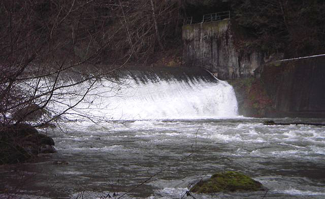
About halfway through the run (6.5 miles from the dam) you reach a diversion dam. The structure must be portaged on the trail on river right (this is a City of Everett PUD rule and violating could compromise future kayaking opportunities). It is possible to put in at this diversion dam by hiking down a gated road on river right if you wish to only run the lower section of whitewater. If this road is gated, the hike is 3.1 miles. Downstream from this point the river picks up in intensity with class IV-IV+ rapids that provide small pools in between for recovery. These are the best drops on the run and you'll likely notice an increase in flow coming in from larger side creeks.
Photo of the dam: Oregon Kayaking Trip Report, 2005
After the diversion dam, you run a few smaller read and run rapids bore reaching the first rapid of distinction. This rapid was a bit tricky; you can see the branch sticking out of river left (pictured below). It was relatively easy to avoid, and like most drops on the run, easy to scout and set safety from below.

First rapid of distinction after diversion dam.

Matt sets safety from below. Here you can see both the sneak line (between the two boulders on the left) and the main line in the middle on the same drop. Both lines work just fine.

From above, the next rapid looked like another read and run. We all routed through the drop, to find a piece of wood that was in the middle of the rapid. Two paddlers in our group “rail slid” over the wood, others were able to avoid it. Enter with caution, as there is pin potential with the current placement of wood.

Lila punches the final hole in the above described rapid. The wood cannot be seen from this photo beacuse it is slightly covered by water. It is located a short distance above where Lila is pictured, in the middle of the channel.
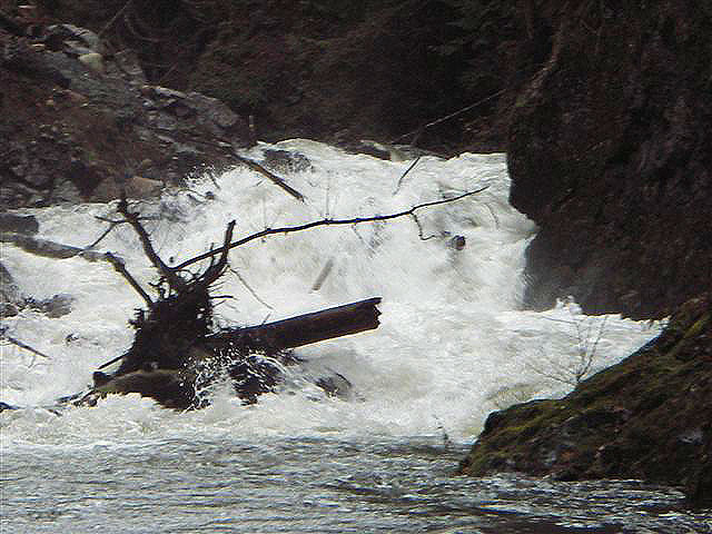
After this point, there is a little bit of boogie until you reach a big pool, which marks the infamous “Landslide” rapid. A group of paddlers in 2004 were separated by the initial landslide, leaving the group downstream, with little water from the dam created by the landslide, and the group upstream with the option to try to cross the slide, or to hike out. They hiked out.
In 2005, a group from Oregon Kayaking went in and the drop was still not runnable. The rapid has since been anthropogenically altered for fish passage. The resulting rapid is more manageable, and it saw numerous descents during the 2015 release.
Oregon Kayaking’s photo from a later trip in 2006.


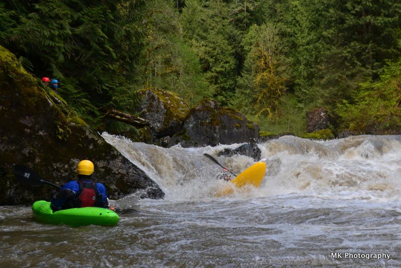
Landslide Rapid, 2015. Ben McKenzie taking home all the points for style, and being the first in the group to probe the rapid. Photo: Nick Hymel

My line. Photo: Nick Hymel

While most of us went deep in the seam on the left, Jacob chose a route down the middle that avoided submersion.
Photo: Nick Hymel

Matt King charging the seam. Photo: Nick Hymel

Jesse Shapiro about to test the depths. You can see the pocket on river left in this photo that many of us flushed into, fortunately it was pretty friendly and everyone was able to hold on and roll up. Photo: Nick Hymel
It should be noted that due to the dynamic nature of this river, and the slide area itself, this drop could change every year. We all felt the drop deserved class 5 attention, but was more forgiving than many rapids with that distinction and was definitely one of the most fun drops on the run. There is also an easy portage option across the slide on river right.
After this, there are a few more read and run rapids before you approach the powerhouse. Pick out a line over the low-head diversion dam, and continue on to Last Nasty- the last formidable rapid on the run. This one is aptly named, as it is easy to float into it and assume it is another read and run. The rapid deserves attention as the wrong line could place you in a sieve or get you pinned. Our group floated into this one resulting in one pin, a few surfs and a lucky line that barely missed the main sieve hazard on the left. The entrance to the rapid is marked by a large boulder in the middle of the river. Take the right channel and find an eddy to scout.
You want to catch the eddy on river right to scout the last part of the drop. You can see the sieve pictured river left, we chose to run the final ledge 5-10 feet off the right bank though many lines were taken during the release.
Last Nasty from below, Ross clearing the hole. Photo: Matt King
From this point there is very little until you reach the Trout Farm takeout. Overall I thought this was one of the more unique and enjoyable runs of the year. We had around 900 CFS, and felt that was a healthy medium flow. Overall I thought this run lived up to my expectations and offered fun, clean rapids, unique scenery and a great opportunity to get on a run that is not often accessible.
Access (From American Whitewater):
PUT IN:
Just east of the town of Sultan (Highway 2 mile 23.1) turn north up Sultan Basin Road towards the Sultan Basin Recreation Area. Follow this road 13.5 miles to Olney Pass. The Culmback Dam Road heads down to the left. This road was gated for the past few years but more recently it has been open and the road is a public easement to Forest Service property (in the past Barry Chrisman, the Hydroelectric Plant Supervisor has answered questions regarding gate access and he can be reached at 425-783-8804). Just before you reach the dam an old forest road turns off to the left (FR 6122, aka the Jenny Ring Road). Drive up this road to a large clearing and start walking. The traditional put-in was reached by following this road to the old log bridge a couple miles downstream from the dam (47.9701N, 121.7228W, WGS84). As a condition of the new hydropower license American Whitewater negotiated the development of a new trail into the canyon that was professionally constructed to Forest Service trail standards and completed in 2014. This trail puts you in the river one mile below Culmback Dam. Scrambling down the face of the earthen dam is tempting but illegal and you likely want to get a bit downstream of the dam to find enough inflow from the sides. Snohomish PUD has installed security cameras here and informed us that they will not tolerate trespassing on the dam. The other difficulty with putting in at the base of the dam is there are reports of some class V rapids in this section that may be difficult to scout or portage. Steep canyon walls limit access between the dam and the old bridge site although there are a couple spots where river access is possible.
TAKEOUT:
Most continue on the Sultan below Powerhouse run and use the Sultan fishing access at Trout Farm Road. You can reach it by taking the first street east of the Highway 2 bridge across the Sultan. After turning onto this street in the town of Sultan, take a left headed back towards the river. When you get to First Street follow it north as it parallels the river. As you pass out of town, slightly less than a mile down First Street, Trout Farm Road turns off to the left. Follow this 1.3 miles to a well marked fishing access point on the Sultan River. Park in the gravel parking area near the road and walk down a dirt road to the river. Alternative access points are available at the Powerhouse but gates will likely be locked by the time you get there, requiring you to continue downstream (they may be open on scheduled release days however).
Subscribe to:
Posts (Atom)