Thursday, February 18, 2016

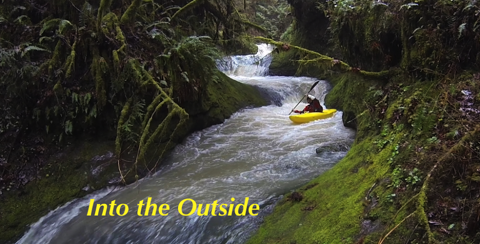
Middle Fork of the North Fork (MFNF) Trask: Barney's Playpen


Runnable levels are about 100 cfs or more coming out of Barney Reservoir, which generally only happens when the reservoir is full (1640.9').  At 100 cfs the bedrock drops are runnable and fun, but the in between is rocky. 200 cfs is a fun flow, and feels more medium in the boogie.  Be cautious about going in at higher levels if you aren't familiar with the current wood situation.

 Don't expect to get on this run early in the season as it takes awhile for the reservoir to fill up each winter. 


The run has many fun class IV rapids, both bedrock and boulder features.  Moving around on the bank is relatively easy compared to other obscure Oregon streams.


110 cfs
 Photo: Pete Giordano


There were two rapids in the mile above the confluence with Elkhorn Creek that had old growth logs requiring extra attention (still runnable and fun-ish).  The run also had a number of alders sprinkled throughout the run, but none that required portaging in Feb 2016.  Be diligent about checking for wood your first time down.  If it hasn't been run in a a couple years, there is probably going to be downed alders in the creek bed, boater-friendly beavers are responsible for keeping this run in good form.

Coming from the Willamette Valley, I have used Turner Road out of Yamhill (Blocked to the public by Weyerhaeuser in Spring 2017, then re-opened in Fall 2017).  Check with them for current accessibility, you can inquire on their recreational Facebook page.

Rules posted at the gate.


Access is also available from the coast, along the NF Trask River Rd.  This route is always available.  It is recommended that someone in your group do some rudimentary map-work before heading up there. Coming from the coast you can drive up along the Trask itself.  

Click to enlarge.

The take out (45.4656, -123.4612) for the MFNF is the same as the put in for this run.

Put in spur (45.4667, -123.4199): Drive to its end, then walk back the way you came a short ways down the road to find the access trail.  Or just schwack downhill to the creek.  This spur is at the 6 mile marker for the mainline logging road, a "6" has historically been painted on the tree adjacent to this spur.

Marker for the start of access trail.
It's not a good path, but orange flagging was there to help with finding the easiest way down.


Put in at the confluence of Coffee Creek and the MFNF Trask: 45.4629, -123.421

Thanks Pete, Nick, Joe, Jesse, Mark and Priscilla for helping suss out the particulars of this run.


-----------------------------------------------------------------------------------------------------------
Story:  Like trail building, but the trail is a creek.
-----------------------------------------------------------------------------------------------------------


Nick Hymel, Pete Giordano and I had run nearby Elkhorn Creek and found ourselves with time left over.  Pete and I decided to paddle the MFNF Trask that afternoon since it shared the same take out and we had seen water entering Elkhorn as we passed by.  I had run it once by myself a couple years before, but only remembered a few rapids and the water had been very low.  I had considered it a one time trip.

This time with a decent flow, I was surprised how enjoyable the run was.  Lots of nice ledges and class IV bedrock rapids dotted the run.  However, there were quite a lot of alders in the stream blocking lines and forcing portages.  The reservoir keeps this creek from flooding, so it doesn't get flushed out naturally like other streams of a similar size might.  Most of these trees were not in rapids, so we had a good time even with the 10 or so portages. 

A good enough time in fact that a group of boater-friendly beavers returned that year, and by the end of a long day the amount of portages had been reduced to zero.  I came back a couple more times that year, and even did a double day with Connor Dixon, not getting out of our boats on the second lap.  The next season I tried to return, but found a locked gate and the run fell off my radar.  Word is the gate is back open in 2021, but the wood has returned and no one has found the time to clear it out for boating yet.


      -jacob

Sunday, February 14, 2016

Riding the surge


1996 is a year most people from the PNW are familiar with, its the last mega flood we have seen in the area.  That year the Willamette River peaked on February 9th, which coincided with my dads birthday.  He and a friend decided to get out and paddle that day.  Below is his story.

My friend John Godino and I decided to kayak through downtown Portland to celebrate my 32nd b-day the day the Willamette crested.  The water was up to the bottom deck of the Steel Bridge and tons of debris were trapped and pushing up against it.  They had the middle section raised, so our big concern was making sure we were in the middle of the river by the time we got there.  The water was up to the seawall in downtown and I was planning on paddling over to it and high-fiving the spectators there!  We put-in at the park just downstream from the Sellwood Bridge after checking with the Harbor Master (works for the Fire Department) to make sure the river was still open to navigation, and he said that it was.  He was a little puzzled as to why I was asking, and I didn't elaborate. 

       
     There were a lot of naysayers trying to talk us out of doing it as we geared up.  They were convinced we would get wiped-out by the large debris rocketing downstream:  huge trees, docks, parts of houseboats, etc.  Our theory was that we would be travelling at the same speed as the debris, so the flotsam wasn't likely to sneak up on us.    Our thoughts about being "just another piece of debris" turned out to be mostly correct, although the weird currents would occasionally surprise us and something large would suddenly come out of nowhere and rush towards us.  The river seemed pretty friendly overall and you could only sense motion when you looked towards the shore and saw it zipping by at 15 miles an hour. 

 Across the river was a tug-boat that had been working full-time for days pushing upstream to keep a group of houseboats from breaking loose from their moorings.  I'm sure that was not cheap, but they won the battle and their moorage ultimately survived.  We were feeling very confident after about 5 minutes on the water and were looking forward to our pass through the center of town, when we saw a Multnomah County Sheriff's river patrol boat making a beeline for us.  They were visibly angry and started yelling at us as soon as they were within earshot.  They said the river was closed and to get on board immediately.  As they pulled us and our boats onto the deck, I was starting to worry we were going to get a ticket or worse, so I quickly played the "Fireman Card."  I told them I was a Portland firefighter and had checked with our Harbor Master earlier to make sure the river was open to navigation.  They said the decision to close it must have come after that conversation, so things cooled down quite a bit at that point.  They did contend that we were crazy, but the earlier animosity died down and they offered to drop us at Oaks Amusement Park, less than a mile from where we started. 

 As a "Plan B" it wasn't bad as we paddled around the flooded rides, even dragging our boats to the top of the giant slide and riding it down into the water - very fun!!  The roller rink was flooded about halfway up the doors, so we peered in and saw the wooden floor floating above the water.  It is designed with flotation and during floods, they run a chain-saw around the edges and it bobs on top of the water, saving the floor from ruin.  Pretty clever!  After awhile, a crew of Oaks Park employees came by in an outboard and pretty tersely told us to leave, so we worked our way to dry land and made the short walk back to our truck.  I'm still a little disappointed that I didn't get to paddle through downtown, but it was memorable regardless.  Hopefully I will live to see another one just like it - or bigger - and can triumphantly complete the run we started 20 years ago. 


A shot from inside Oaks Park that day.


Below is an Oregon live article with a couple videos. The first video is around Portland, and the second one is in the Willamette Valley, locals will probably will recognize some of the locations.


Remembering Oregon's epic 1996 flood: 20 years ago (photos)  


Thursday, February 4, 2016

NF Alsea

Photo: Lucas Rietmann

The NF Alsea is one of those runs that is on a lot of Oregon boaters list of streams they want to paddle.  It is also one of those runs that stays there year after year as people put it off for something closer, logistically easier, or just a little more well known.

The trip is an odd combination of intermediate difficulty and mini-adventure.  In the past paddlers spent hours driving around logging roads on the shuttle, often coming out on a different road than they went in on.  This kind of adventure is usually not sought after by those honing in their skill set.  Then once boaters acquire an advanced skill set, they may feel the whitewater is not worth the effort.

It's a bit of a drive from Portland too.
Less than half an hour to the take out for those Corvallis boaters though.


 I would encourage both demographics to seek out this river, I feel confident both would find the experience rewarding.

I was one of those paddlers who had the run on my list, but never pulled the trigger before because I just couldn't justify a one hour each way shuttle for what I (incorrectly) interpreted as a class II run with a couple class III's and two decent rapids.  Plus, when this run has water, lots of other runs do too.

Lucas Reitmann has been in there a couple times and has had good things to say about it.  When he decided to plan his third trip in there, I figured it had to be good if he was returning yet again and for his second time this year.  Plus he had figured out how to cut the shuttle down to 30 minutes.

Typical shuttle view, with the NF Alsea being just before that final ridge.  Keep this proximity in mind if the question of hiking out presents itself.


There was potential for a large group, but by the time we met in the morning it was down to Lucas, Priscilla and I.  We drove the short distance from Corvallis to the Alsea Fish Hatchery take out and left a vehicle near the staff gauge (reading 2.25) at a parking lot complete with porta-potty.

We also had about 800 on the Pat Welch Gauge, on January 24th, 2016


Loading into Priscilla's vehicle we headed back the way we had come on HWY 34, turning left onto a gravel road in about 3.3 miles.  Staying on BLM Rd 10 for 9 miles brought us to the put in.   Lucas had only done this run low and high, so was pleased to see it at a nice flow, a little under medium.

The falls comes up quick.  As the river bends left stay right to give it a scout.  It had a log in it on this trip that created an awfully thin line on the right.  None of us were sure we would avoid the log so made the easy portage along the right.

Falls with the log

Vanhorten Falls from a park a huck session a couple summers ago.


A large group went back on Feb 18, 2017 with the hatchery gauge at 2.5' and the NF Alsea gauge at 1,100 cfs.  Almost ten people ran the falls that day, the log proved to be avoidable.

Lexi Esperanza avoids the log.


We continued downstream through some interesting channels separated by tall grass islands and banks.  The whitewater wasn't eventful, but the islands were unique enough to keep us engaged as we moved downstream.  There was one log in this stretch, but we were able to get under on the right.

Eventually things picked up and before long we were running some engaging class III rapids.  This portion of the run was better than I had anticipated.


These built towards class IV before a larger horizon presented itself.  We eddied out on the right to scout a large ledge.  At first glance it looked a little funky, but upon further inspection there were two lines that looked good.  We all chose the one furthest to the right, sliding through a small trough into  a bit of a pillow and off a short drop into a hydraulic.


                                                           Photo: Lucas Rietmann

Below here things tapered off and eventually we were floating past farms with grass again lining the bank.  A dam at the fish hatchery caused the water to go flat for the first time on the run.  We did the portage on the right, wondering where people had ever run this heinous drop in the past.

It was a short float below here to the take out, passing the staff gauge and a multitude of fisherman.  One of them indicated he would prefer we paddle as close to him as possible, as opposed to as far away as possible like we had been doing.

If you have this run on your list, I would recommend checking it off sooner than later.  I would say it like many others have said about the Grays; "The NF Alsea is one of those rivers you keep putting off, but once you do it you wonder why it took so long".

Logistics can be found on the AW page.

  -jacob