Thursday, July 27, 2017

Woodenrock Creek


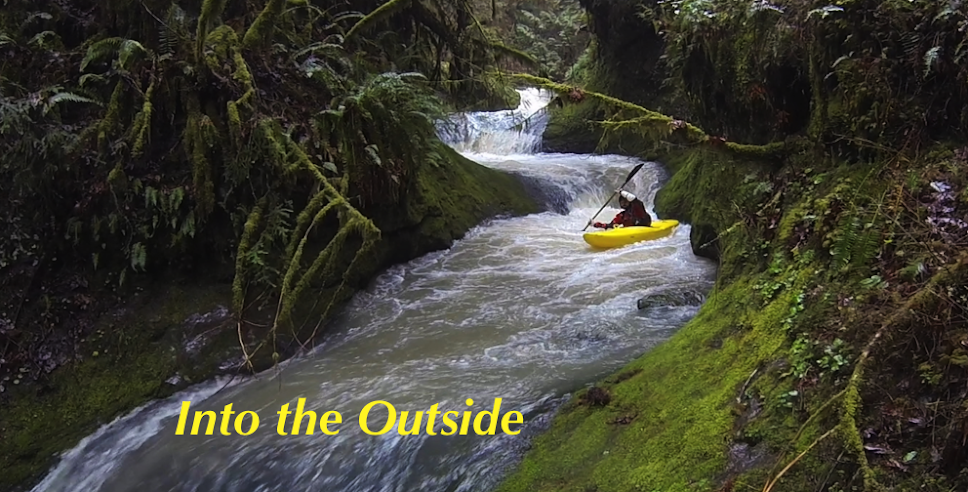
Woodenrock Creek has a short section of good whitewater.  It is a tributary to the South Fork Coquille and has convenient road access via a gravel logging road.  The put in is at a bridge, with a beautiful 30-ish foot falls visible below.  The falls can be thoroughly scouted before putting on.  Safety for the first person can be set on river left by scrambling down from the road.  The first person to go over can set safety for everyone else from river right after landing.

Priscilla Macy dropping Woodenrock Falls.

Below the landing pool the creek enters a hundred yard section of ledgy whitewater, which can be scouted or portaged from river right after dropping the falls.  


The bedrock ends abruptly and we eddied out on river left to walk up the clearcut back to the road and our car.  You could continue down to another bridge, but satellite imagery shows inordinate amounts of wood before the bridge is reached.


We were there on March 30, 2017


Bridge over the falls:  42.8301, -123.9259

Friday, July 21, 2017

Yellowstone Creek

Yellowstone Creek is a small tributary to Quartzville Creek, if you have run Upper Quartzville Creek you have crossed over this one.  Ben Mckenzie's brother had told him about a small waterfall on the creek, so a couple times after Quartzville we/I had walked up there to take a look.  It looked like a fun drop, but nothing special so each time we made excuses not to bring our boats up there.  Finally, after finishing a trip on upper Quartzville we were driving by mid-day and Priscilla and I couldn't come up with any reason not to carry our boats the short distance up the creek to run the falls.  I'm glad we did, it was a fun plop, good enough that I carried back up for a second go.


I walked a short distance upstream of the falls while we were there and thought the creek looked runnable, and the next week I received this information from Geoffrey Marcus via the Facebook:  I did some stream surveying up their a few summers back and it had decent gradient... Ive only been about 1/2 mile upstream of the drop, and it was mostly steep boulders. A little bit of bedrock here and there but nothing quite like that drop.

So this creek has joined a long list of other creeks that I may or may not run someday.  There is in fact a logging road that crosses the creek up there and some real gradient.  If you are up for a short adventure, consider checking this one out after a morning on Quartzville some time.

The first half mile drops 280 feet, the rest of the run is in the 250 fpm range.  


This was the flow the day we ran Yellowstone Falls, I think the flow we had would be a good first time flow for exploring the rest of the creek as well.


                           -jacob

Friday, July 7, 2017

Rock Creek (Baker City) / WF Eagle Creek (Wallowa's)

In the morning of May 27, 2017 Joseph Hatcher, another guy and I checked out the Rock Creek that flows off the East side of the Little Alps near Baker City, OR.

The NF John Day @ Monument was running about 3,000 cfs from snowmelt.

It was very steep (700 fpm+ for a portion: 44.8906, -118.0976) and we found a bouldery, eddy-free mountain stream cascading at a rapid pace down the mountain.  We discussed Joseph and the other guy running the creek, with me standing along the bank to catch them above wood hazards since eddies were not available.  In the end we felt it was more sketchy than we wanted to deal with and no one put on.  Neither Killamacue Creek or the section of Rock Creek above the Killamacue confluence looked any friendlier (in fact they looked worse).

Typical Rock Creek


There is a fools hope that a run might exist below the S Rock Creek Lane bridge, maybe a local would enjoy checking out that section.  It looked less steep than the parts we scouted, but scouting/portaging might put a boater on private property. The run we scouted would probably also be fun if someone knew it was completely free of wood, and could be run put in to take out without having to stop, though its unlikely that scenario will occur.

We then headed over to the south side of the Wallowa's and the Eagle Creek drainage, where Joseph Hatcher and I paddled the WF Eagle Creek.  We took out just upstream of the NF-67 bridge and put in a couple miles above that at a low water crossing, upstream looked flatter and woodier than the portion we ran.  The part we ran resembled a wider, less steep version of Rock Creek.  We found the run to be stressful class III+ with plenty of wood and few eddies.  We scouted every foot of stream eddy to eddy style and the eddies were more often difficult to catch than easy.  We had few portages, the fun came from puzzling the river together and not from the whitewater.

I'd not do it again, but was happy to find out what was on the run.

 We had 1300 cfs on the Eagle Creek Nr New Bridge gauge (which can be found here).

And about 2700 cfs on the Imnaha gauge, May 27, 2017, the Saturday before Memorial Day.

Put in:  45.0444, -117.4617
Take Out:  45.0235, -117.459

 -jacob
Thursday, July 6, 2017

East Fork Eagle Creek (Wallowa's)


 Photo: Michael Freeman

Michael Freeman and I checked this out in the Spring of 2013.

We hiked 6 miles to this point 45.1404, -117.3032, camped, then hiked up and scouted some more.

Camping in a drizzle.
 Photo: Michael Freeman


We didn't find anything we wanted to run that high up so returned to a meadow and floated down from there.  If I went back I'd put in here: 45.0869, -117.3067 where a 2.5 mile hike puts you in right at the top of the worthwhile whitewater.

To get there, drive to the East Eagle Trailhead.  Hike the trail on river left a little under 2.5 miles.  The spot to put in is notable:  For one, it is where the trail crosses over Curtis Creek.  Second, there will be another small tributary sliding down the mountainside into East Eagle from the other side of the creek.  Finally, there will be a large class V-VI rapid on East Eagle.  Scramble down to the creek and put in just below this rapid, which pinches down and drops 20+ feet.

Right around the corner the creek narrows, you won't have far to go before you will want to scout a  triple cascade.  There was an unfortunate log in the final tier when we were there in 2013 so we portaged the set on the left via the trail.

 Returning to the creek via a short glissade.
Photo: Michael Freeman


Downstream was a fun section of whitewater with a handful of unique bedrock rapids in the class IV-V range.

 Photo: Michael Freeman

Below the bedrock the creek looses character and runs through boulder channels that appear to change year to year.  The creek still has gradient so it kept us focused and we had a good time splashing down it.  We had one short log portage in this section in 2014.

At the very end was a bridge that had been destroyed by high water, we floated over it but its definitely worth a scout at the beginning of the day on your way up.

If you wanted a long day of boating you could combine this section with the main stem of Eagle Creek.


We had 940 cfs on the Eagle Creek Nr New Bridge gauge (which can be found here).


The Imnaha gauge was also fluctuating between 1200 and 1400 cfs from snowmelt when we ran the EF of Eagle Creek.


Click to enlarge map


    -jacob