BETA
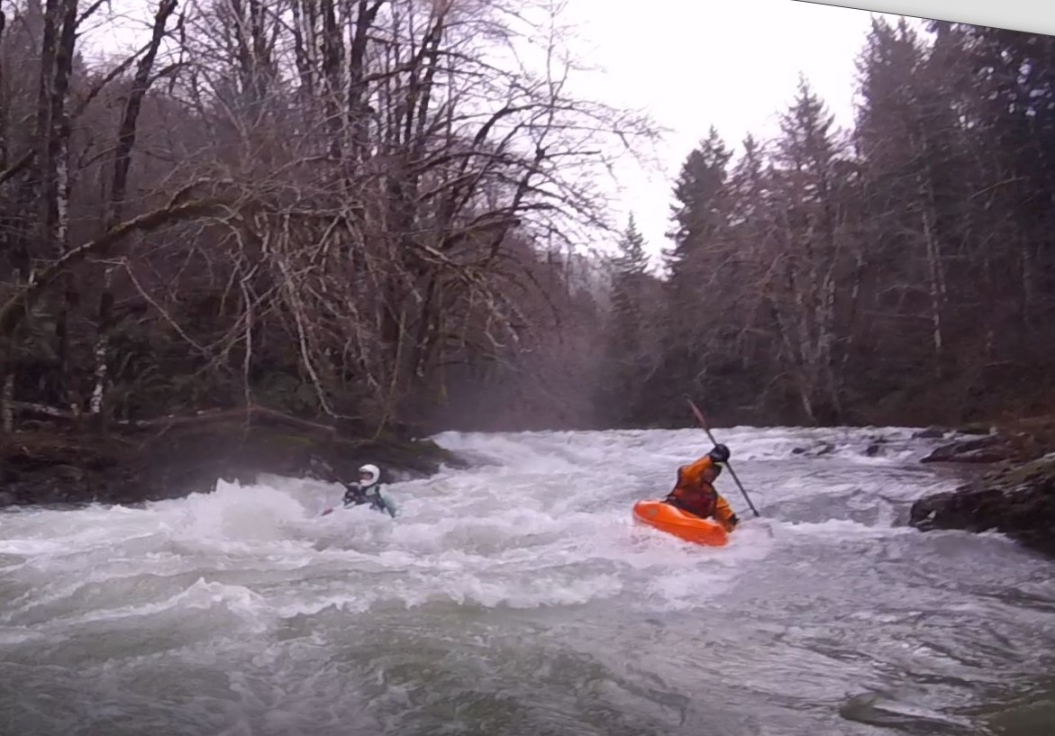
Stream: This is an interesting creek in Oregon's northern portion of the coast range. Access is made difficult by private land, but it is possible to run if you are looking for adventure not far from Portland. The run reminded me of an extended version of Hagen Creek, with lots of little ledges...


...a few challenging boulder gardens...

...some enjoyable boogie...

And a true coast range feel.

Scouting is reasonable, and it's typically pretty easy to move along the bank. Though the eddies can be small at good flows.

Since the kind of people who would do this run are going to be the adventurous type, I'm going to leave it about there with my description, and let the mystery be the appeal. Below are just a few notes I would like to share with any potential future paddlers of this run.
- Walking around on the banks is pretty easy, and so is portaging for the most part.
- The eddies tend to be small at good flows.
- Aggressive boat scouting could get you into trouble on this creek, I recommend scouting for the next eddy on this run, and definitely blind sections.
- While the obvious option is to do the run as a day trip, a less obvious option worth considering would be to do it as an overnighter and take out way downstream on the Trask.
- There was wood present, but it was cleaner than I had expected.
----------------------------------------------------------------------------------------------------------------------------------------------
Story/Notes
----------------------------------------------------------------------------------------------------------------------------------------------
----------------------------------------------------------------------------------------------------------------------------------------------
Priscilla and I did this during the first large rain event in November 2021. She was going to get hip surgery the next month, so she wanted to get one last adventure in before being idle for 3-6 months (the doctor said she wasn't going to be able to make her hip any worse than it already was by doing something like this).
We were impressed with the quality of the streambed. If access was easier, it would be bordering on classic quality.
We ended up not finishing the run, both of us were injured so were moving slow, and the run had enough going on that we were just overmatched on this day. We both hope to return with healthy bodies some day and get to paddle more of the rapids we walked around. As it was, we had a somewhat harrowing and trying hike out. Highlights from that 600' vertical bushwhack out in the dark include Priscilla throwing up from pain, and myself climbing an exposed section of cliff just before reaching a logging landing (which Priscilla also had to climb, but with the protection of a rope). From there it was 4+ miles of navigating logging roads back to our put in car, where we slept. Priscilla said it was the second most painful thing she has done (just behind the hike out that tore the labrum in her hip).
Our hike out route.

I returned the following week to retrieve our boats. I wanted no part of hiking in the way we had come out, so used LiDAR to find an old road grade not visible in imagery or topo maps.
Bare Earth.

I was happy is was predominantly fern-covered, and not slash-strewn.

I was able to get back to where we had hiked out, crossing the creek twice where bridges were no longer where they once were. My IK was mostly deflated after a week in the woods, so I pumped it up and headed downstream.

I paddled my boat out first, then hiked the same route back up to get Priscilla's boat. There was only one significant rapid, which proved to be fun once a log was relocated.

The rest of the run was pleasant floating in a small gorge down to where I had parked.

On the drive home I scoped out access to the headwaters of the Tualatin, and another obscure run made it's way onto my list.

Access: The current access situation is the limiting factor for this run, gates mean that there is a minimum three mile hike in. Because it is somewhat complex, and because this run typically flows during the short days of the year, it is important people get the logistics right. For this reason, I am going to give pointers that will help people research their own way in, rather than a full description, so that people are required to make their own plan and gain a good knowledge of the area before attempting the creek.
Take Out: 45.4654752492765, -123.46132099884476
Beginning of hike: 45.501384861467244, -123.4001576886222
Put in for class IV(V) run (lower put in): 45.51780835808607, -123.41947900612611
Put in for class V run (upper put in): 45.527327100594945, -123.41976781430597
*there is even potential to put in a little higher
Priscilla came across this handy map, we found it accurate in 2021.


This shows the route we hiked in along. Blue dotted line is road hike. Yellow dotted is bushwhacking. Yellow solid is spur road. Orange line is an upper put in option.

Here is that alternate put in route:
· Turn off HWY 6 at Rogers Camp
· University Falls rd
· Saddle Mountain rd
· Cedars rd
· C Line road
Stimpson gates don’t start until C line road, and shouldn't force a hike until about here: 45.54105493489647, -123.40831600136421
Flows: There is a unique rock at the take out that works as a visual indicator for the run. The area around it would be prone to change in a large flood, but the rock serves as a convenient indicator for now.


Looking downstream from the bridge at the rock.

The rock has two fins. If the lower fin (pink arrow) has no exposed sections, the creek can be paddled. If there is little bit of water going over the upper fin (blue arrow) the creek is at a great flow. If the upper fin is making a hole or wave, the creek is high. Due to the nature of the creek, I would not personally want to run it at high water.


There are some correlation gauges in the area. For a return trip I'd like to see Scoggins Creek over 200, the Trask River over 3,500 and the Wilson River over 5,000. However those are just estimates, here are the graphs with color-bars coordinating to the previous photos of the rock at the take out.