There are a lot of things you won't find if you are not looking for them, here are some fun creeks found not far off of the proverbial beaten path and one that sits squarely in the middle of it.

Wednesday, January 27, 2016
Thursday, January 21, 2016
PDXkayaker Film Fest 2016

The 2016 PDXkayaker film fest was a great time yet again. Events like this are a big part of why the PNW boating community is such a good one to be a part of. And these events happen because of Next Adventure, thanks so much for making it happen year after year.
Priscilla and I entered a video in the film festival this year. It is an extended version of an earlier video we put out portraying our trip to the Merced River down in Yosemite National Park. The film-fest version has more of the back story that led up to that trip. This extended version is embedded below.
Our American Whitewater Dream (PDX Film Fest Entry 2016) from PMacy on Vimeo.
Nick also got one in there. His video better reflects the year we had here in the PNW. Waaay too much fun!
Lily Dipping and Day Tripping from IKNick on Vimeo.
Nick also got one in there. His video better reflects the year we had here in the PNW. Waaay too much fun!
Lily Dipping and Day Tripping from IKNick on Vimeo.
-jacob
Thursday, January 14, 2016
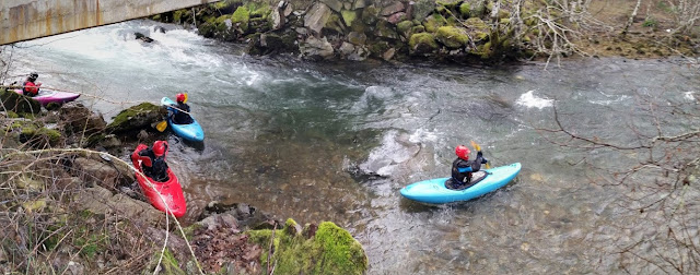
Molalla: Table Rock Fork

Photo: Lucas Rietmann
Aside from a trip through the lower gorge I had done many years ago, none of us had run the Table Rock Fork of the Molalla. We decided it would make a good trip for the day so headed up to check it out with the Molalla gauge around 4,000 cfs, dropping to around 3,000 cfs by the end of the day.
Oregonkayaking mentions some larger rapids above the regular put in, so we drove up to the confluence with Lost Creek where a gate marked our roadside put in.
The first mile down to the next bridge was busy class III with one log duck that some chose to portage. This bridge would also be a decent put in.

Bi-passing the log duck.

Below here was some more busy water leading to a long rapid near a quarry.
Some boogie.

Photo: Michael Freeman
Bi-passing the log duck.

Photo: Michael Freeman
Getting back in the water after a short break at the alternate put in bridge a mile below Lost Creek.

Photo: Michael Freeman
Below here was some more busy water leading to a long rapid near a quarry.
The entry to this rapid was a short flume/slide into a hydraulic before an eddy on the right where we were able to scout the next part of the rapid, which was long and bouldery.


The lower part paddled smooth, despite a dubious looking boulder pile in the middle.
 Photo: Lucas Rietmann
Anna finishes off the bouldery part of the quarry rapid.

Priscilla in the top half of the quarry rapid, with the flume visible in the background.

Photo: Michael Freeman
Anna boofing away.

Photo: Michael Freeman
The lower part paddled smooth, despite a dubious looking boulder pile in the middle.
Priscilla about halfway through the quarry rapid.

Anna finishes off the bouldery part of the quarry rapid.

Photo: Michael Freeman
More boogie water led to the standard put in, below which the splashy rapids continued. A large landslide on the left a short ways into the standard run deposited many logs on the right bank, these were scattered along the shore for the next hundred yards and have the potential to become mobile with the next high water event.
This landslide, along with the largest boulders seen yet mark the largest rapid of the standard run called The Pinch. The Pinch, which is about 100 yards below the landslide, has collected a couple of logs that came down during the mass wasting event.
This landslide, along with the largest boulders seen yet mark the largest rapid of the standard run called The Pinch. The Pinch, which is about 100 yards below the landslide, has collected a couple of logs that came down during the mass wasting event.
The logs in The Pinch did not complicate the line at all, but made the consequences for a mistake a little higher. The scout and/or portage is easiest from the left. We ran center to left in the first part of the rapid, then right to center in the second. The write-up on Oregonkayaking refers to a mandatory side surf in the bottom part of this rapid at higher flows. The level we had was not high enough for the last hole to be sticky and we all came through easily.

Anna cruising through the top portion of The Pinch.

Photo: Lucas Rietmann
Below the Pinch the stream rolls along for almost 4 miles of continuous splashy water. It was all easy to read and run, with two wood hazards. Both of these wood hazards were roadside, neither a mandatory portage.
More continuous and fun whitewater continued below here for a mile or two down to the take out. There was never a dull moment on this run, yet once below the Pinch, neither was there any point that required strong concentration. I was surprised by the quality of this run, and would not hesitate to do it again. We all agreed that even though the whitewater was easier than the Miracle Mile (a similar distance for us), it was decidedly more enjoyable.
Lucas did some kayaking too.

Logistical information and additional insight can be found at Oregon Kayaking, American Whitewater, or Oregon Paddling.


Anna showing her stoke about the run with her patented lamma-claw.

-jacob
Thursday, January 7, 2016
Upper Upper Washougal
All photos by Jarred Jackman

Jarred lives close by and last weekend decided he was ready to see what the run was all about, so he assembled Brandon Lake, John Edwards, Priscilla Macy and myself in Washougal on Sunday Dec 20. We left a vehicle at Dougan Falls in case we decided to continue down through the waterfall section, which looked to be a a friendly flow. We left a second car at the confluence with Stebbins Creek in case time did not allow for further paddling.
The road to the put in got snowy pretty quickly, bottoming out Jarred's CRV. Though Priscilla's Exterra did not have this same problem. We all made it to the put in, but with more snow coming down we were worried about getting the vehicles out at the end of the day. Priscilla decided she was not comfortable dealing with an un/un and committing gorge in the snow so decided to drive one of the vehicles back to the take out. I decided I would drive the other one out and the two of us could go run the NWF Washougal while Brandon, Jarred, and John could collect the beta for the Upper Upper Washougal. With the added comfort of not having to retrieve vehicles at the end of the day.
The shuttle road is blocked 1/4 mile short of river level, next to a compelling, but dangerous falls on Prospector Creek. The walk along the decommissioned road to the put in went quickly and we watched the team paddle off on what looked to be a perfect water level.
The drive out went well and Priscilla and I had a good day on the NWF, but this report is to get the beta out about the Upper Upper. From what I heard from Jarred and John, it is very much worth doing and the un/un is neither un, nor un. They report that while the gorge is committing, scouting options are abound.
I'll turn it over here to Jarred here for an on the water report:
-----------------------------------------------------------------------------
Jarred's Report: The Bennett Guide mentioned a class II warm up but we put on and were immediately met by a III+ ledge that dropped into a narrow landing. Many of the drops on the run had some good lines and some not so good lines. With various rocks still showing and sub-surface boulders it was easy to get bumped offline. This section seemed reminiscent of Trout Creek near the Wind. This isn't a surprise when you look at the map and realize they are VERY close in proximity.

Early On

A couple of these bouldery ledge drops led us to the lip of the first falls (10'+) which is very marginally runnable on the right but the safe line is scraping over the middle into a deep pool. Scout right. The Washougal is plagued by shallow landings and this section is no different, scout carefully.

Typical Rapid on the Upper Upper Washougal

We ran a few more boulder garden style drops and found ourselves at the start of the Gorge. I was expecting an UN UN akin to the gorge on the Carbon. This was nothing like that. I don't think levels would affect this scout or portage.

We scrambled over large boulders and grovelled through devil's club, all on the left bank. Water levels would never negate this option. That said, the portage isn't for the faint of heart and the small spot to gain access to the river could prove difficult to find. We portaged due to difficult WW, tight must make slots, and a bad piece of wood. We put back in after the ledge drop after the Gorge. At portage level you should look for a large fin of rock that seems to block your progress and drop in just upriver of that fin. There should be a ramp that leads down to the river and will offer good seal launch options. We used 15' of rope and the ordeal took us 1.5 hours. If this portage becomes standard, I could see it being similar to Elbow Room on the Ohane (but longer), 30 minutes at most.

Beginning of the Un/Un

We scrambled over large boulders and grovelled through devil's club, all on the left bank. Water levels would never negate this option. That said, the portage isn't for the faint of heart and the small spot to gain access to the river could prove difficult to find. We portaged due to difficult WW, tight must make slots, and a bad piece of wood. We put back in after the ledge drop after the Gorge. At portage level you should look for a large fin of rock that seems to block your progress and drop in just upriver of that fin. There should be a ramp that leads down to the river and will offer good seal launch options. We used 15' of rope and the ordeal took us 1.5 hours. If this portage becomes standard, I could see it being similar to Elbow Room on the Ohane (but longer), 30 minutes at most.
Shot from the fin rock area, indicating where a return to river level is feasible.

From river level, on a return trip
Photo: Adam Edwards

Once back on the water the river turned left and out of sight, we boat scouted as aggressively as was prudent and I think we bank-scouted two drops. One of these ended in a 10' drop in which the right side will mangle you and the left side goes well. Both look good from upstream, so beware. It's easy to eddy hop too far on this run and get into trouble.
The nature of the drops were mostly ledges and boulders with small 2' - 4' drops stacked up. There was a fair bit of mank but normally clean lines could be found without much trouble. The river geology in the harder WW reminded us of the Ohane or UUC. If you know the lines, you're good, if you don't, it could get confusing.

Once we were out of the class IV the river valley opened up a bit, we saw some eagles, stumbled upon some nice surf waves (the Washougal always delivers with surf) and the run returned to the description in the Bennet guide.

We ran a 10-15' drop river left that was near some houses, then we made our way to Doc's Drop.

We scouted and ran this left and it was a classic way to end the trip. It consists of a couple smaller drops and a slide culminating in an upturned lip that launches you (think Boulder Sluice without as much speed.)
Portage options were usually available if a drop was not to ones liking.

Once we were out of the class IV the river valley opened up a bit, we saw some eagles, stumbled upon some nice surf waves (the Washougal always delivers with surf) and the run returned to the description in the Bennet guide.
John getting in some bonus surf action.

We ran a 10-15' drop river left that was near some houses, then we made our way to Doc's Drop.
Clean waterfall near the end of the run.

We scouted and ran this left and it was a classic way to end the trip. It consists of a couple smaller drops and a slide culminating in an upturned lip that launches you (think Boulder Sluice without as much speed.)
So there you have it. No UN-UNs but plenty of challenges and must make moves in a difficult to access river canyon. You'll like this run if it's not at your peak skill level. If it is, well, I hope you don't get injured. Get an early start as you should treat every descent of this canyon as a first. Too many options for changing rapids or dangerous wood.
--------------------------------------------------------------------
Flows: On Dec 15, 2015 Jarred, John and Brandon reported an ideal/medium first time flow with the Washougal reading 1,800 cfs and dropping @ Washougal and 3,500 and dropping @ Hathaway.
Shuttle: The road peaks out just under 2,000'. There was more snow on the north side of the shuttle than locations at the same elevation on the south side, the difference was significant enough I felt it was worth mentioning.
From the Stebbins Creek confluence (conventional take out for this run) continue upriver 4.3 miles (staying right at 1.9 miles) to a point where a number of roads split off from the main one (the 4-way intersection mentioned in the Bennett Book). There are two roads that veer off from the main road to the right at this intersection, you want to take the right turn that goes downhill. After turning right, you will continue downhill 1.5 miles to a bridge over Prospector Creek. Immediately after crossing this creek turn left and continue just shy of 2.5 miles to where this road ends. There is a small pullout adjacent to Prospector Falls less than 50 yards before the road ends that makes a good spot to leave vehicles. From here just continue down the roadbed on foot until it is easy to get down to the Washougal and put in.

Thursday, December 24, 2015
Bridal Veil
Priscilla Macy dropping the bottom tier of Bridal Veil Falls.
~1,200 cfs on the Bull Run nr Multnomah gauge.

Photo: Andy Ploon
Bridal Veil gauge beta:
This drop is commonly run when it has been raining a lot in the Portland area. If you are willing to take a hit, it has been run pretty darn low. If you want medium flows, with a nicely aerated pool, shoot for about 1,000 cfs or more on the Bull Run near Multnomah gauge. You can expect around 15% of the flow on that gauge in Bridal Veil Creek. I have never seen (in person or photos) this drop with too much water in it to run.
It's been rafted too, here is a video from the first time that happened.
Location: 45.5548, -122.1802
The falls is found taking the Bridal Veil exit off I-84, about 20-30 minutes East of Portland. After taking the exit, turn right/West shortly onto the historic highway (aka follow the signs). There is a parking area and trail to the base of the falls on river left off of the historic highway. Poke around a bit and you will find a way to get to the seal launch between the two falls. People hucking the upper tier put in where the historic highway cross Bridal Veil Creek. The falls can also be accessed from behind the Bridal Veil Post office at the end of the gravel road.
Thursday, December 17, 2015
Class V Mentality
I often find myself thinking I'd be happier if I chose to run class III-IV from here out, to let go of the stress both on and off the water that comes with paddling class V. Yet while the reward is for the most part both intangible and ineffable, for many of us it is paramount. The challenge of descending a new, difficult river will continue calling us back week after week and year after year.

Jeff Compton gives his two cents on the class V mentality.
As Matt has said, "sometimes when you push the limits, the limits push back".
Jeff in a pushing match (he and Dan both stayed in the boat on this descent of Sarlac in Kenobi Gorge).

Thursday, December 3, 2015
Siouxon
This is one of those runs a lot of people talk about doing, yet few actually do. The logistics are more challenging than your average boating trip with snow conditions, hiking, daylight and flows all weighing in to the equation.
I kept putting it off but after hearing from Jeff Compton, Scott Michael, Nick Hymel and others that this was a special run I decided that I would give it a go when the next opportunity presented itself.
A couple weekends ago I got that chance, others also wanted to see it for the first time (Priscilla Macy, Ben Mckenzie, Jake Brown) and two were happy to go back (Scott Michael and Matt King). We met in Jantzen Beach at 6:30 and decided to do the shuttle this time around. Utilizing a spur road we reduced the hike to 1.5 miles of easy downhill or flat hiking.
The shuttle is not for everyone, it requires modest navigation skills and adds a big chunk of time at the end of the day. Those I have talked to who have hiked from the bottom say its pretty darn easy as far as 6 mile hikes go, plus when you finish the run you are done and can head home instead of having to retrieve your car. That said, I might still do the shuttle next time.

Below is the hike that we did, including an easy 5 minute bushwhack to meet up with the trail.


The run starts off right away with fun bedrock features, these are all pretty straight forward but keep an eye out for wood.
The first twenty footer (Upper Siouxon Falls) is really fun and clean. Matt sent us all off blind which was a fun way to do it, a couple of us even went back up for seconds.
More high quality intermediate bedrock rapids with an occasional wood hazard continues until a big and obvious horizon line presents itself, scout/portage Middle Siouxon Falls on the left. We thought we were in trouble for daylight at this point as we had been moving very slowly so we all portaged what looked like a good drop without giving it a good look.
Downstream more excellent intermediate bedrock whitewater continued, broken up by stretches of class II-III.
Eventually after an extended class II stretch an obvious horizon presented itself at the double drop. We scouted right, Ben went middle off verbal beta because he was chilly and didn't want to get out of his boat, but also didn't want to miss out on the big boof in the middle. The rest of us scouted right and three of us ran left while a couple others walked on the right. The left side was fun and more friendly than it had looked from the right bank.
We paddled a ways more to the horizon line at Lower Siouxon Falls, again the scout/portage is on the left. We looked at it for a short bit and I decided it was too doable to leave it unrun so gave it a go. I was where I wanted to be from top to bottom, but was tossed nearly 180 degrees by the big feature at the transition resulting in a descent that ended up being more spectatorially amusing than technically proficient.
More class II broken up by some III+ continued a little less than 1.5 miles to the West Creek campground where we took out. This take out is not obvious and we only knew it was there because Jake Brown had hiked there before and recognized the spot. West Creek is the second creek to enter from the left below Lower Siouxon Falls, if you pass that creek you are in for a long day. The preferred take out is about 100 yards above that confluence on the left at a clay bank. I would suggest following Oregonkayaking's advice and scope out your take out before putting on.
We did the short hike back to our vehicles and set about running the long shuttle with half hour or so of light left, finally meeting at Nick's Diner in Amboy for dinner around 8pm.

We were there November 15 and thought flows were good. Could have gone higher or lower.

-jacob
I kept putting it off but after hearing from Jeff Compton, Scott Michael, Nick Hymel and others that this was a special run I decided that I would give it a go when the next opportunity presented itself.
A couple of the videos that got me excited about Siouxon Creek.
From Nick Hymel
A couple weekends ago I got that chance, others also wanted to see it for the first time (Priscilla Macy, Ben Mckenzie, Jake Brown) and two were happy to go back (Scott Michael and Matt King). We met in Jantzen Beach at 6:30 and decided to do the shuttle this time around. Utilizing a spur road we reduced the hike to 1.5 miles of easy downhill or flat hiking.
The shuttle is not for everyone, it requires modest navigation skills and adds a big chunk of time at the end of the day. Those I have talked to who have hiked from the bottom say its pretty darn easy as far as 6 mile hikes go, plus when you finish the run you are done and can head home instead of having to retrieve your car. That said, I might still do the shuttle next time.
Oregon kayaking has accurate shuttle directions and a good description of the run.
Hiking in

Below is the hike that we did, including an easy 5 minute bushwhack to meet up with the trail.


The run starts off right away with fun bedrock features, these are all pretty straight forward but keep an eye out for wood.
The first twenty footer (Upper Siouxon Falls) is really fun and clean. Matt sent us all off blind which was a fun way to do it, a couple of us even went back up for seconds.
More high quality intermediate bedrock rapids with an occasional wood hazard continues until a big and obvious horizon line presents itself, scout/portage Middle Siouxon Falls on the left. We thought we were in trouble for daylight at this point as we had been moving very slowly so we all portaged what looked like a good drop without giving it a good look.
Downstream more excellent intermediate bedrock whitewater continued, broken up by stretches of class II-III.
Eventually after an extended class II stretch an obvious horizon presented itself at the double drop. We scouted right, Ben went middle off verbal beta because he was chilly and didn't want to get out of his boat, but also didn't want to miss out on the big boof in the middle. The rest of us scouted right and three of us ran left while a couple others walked on the right. The left side was fun and more friendly than it had looked from the right bank.
We paddled a ways more to the horizon line at Lower Siouxon Falls, again the scout/portage is on the left. We looked at it for a short bit and I decided it was too doable to leave it unrun so gave it a go. I was where I wanted to be from top to bottom, but was tossed nearly 180 degrees by the big feature at the transition resulting in a descent that ended up being more spectatorially amusing than technically proficient.
More class II broken up by some III+ continued a little less than 1.5 miles to the West Creek campground where we took out. This take out is not obvious and we only knew it was there because Jake Brown had hiked there before and recognized the spot. West Creek is the second creek to enter from the left below Lower Siouxon Falls, if you pass that creek you are in for a long day. The preferred take out is about 100 yards above that confluence on the left at a clay bank. I would suggest following Oregonkayaking's advice and scope out your take out before putting on.
We did the short hike back to our vehicles and set about running the long shuttle with half hour or so of light left, finally meeting at Nick's Diner in Amboy for dinner around 8pm.
The downside of the car shuttle; once you finish the run you still have over 2 hours of driving before you finally exit the Siouxon drainage.

We were there November 15 and thought flows were good. Could have gone higher or lower.

-jacob
Subscribe to:
Posts (Atom)