

BETA
III-IV(V)
18 miles (+6 on reservoir)
Stream: This section flows through the Middle Santiam Wilderness Area and provides an overnight kayaking opportunity for intermediate to advanced boaters. While the overnight option is the best way to see this section of river, it can also be run in a (long) day, if someone is in a rush or the conditions are too Oregon (i.e. raining, unpredictable flow situation, and cold). Overall the run is class II-IV, with two class V rapids that can be avoided.
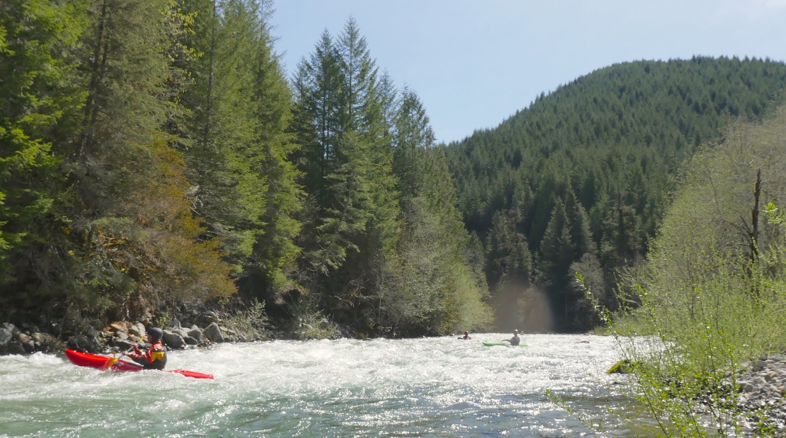
The first of the class V's (The OK Corral) is just below the put in bridge and can be scouted before putting on from the ridge the following photo is taken from.

If you don't like what you see, there is a road on river left with a spur that you can follow down towards the creek, followed by a bushwhack. I haven't done that, but heard it's not difficult. Or, people have put in on and run the last 1/4 mile of Lake Creek before, which is on river-right and has road access as well.
Pete Giordano on the day of the first descent of the OK Coral in 2008.

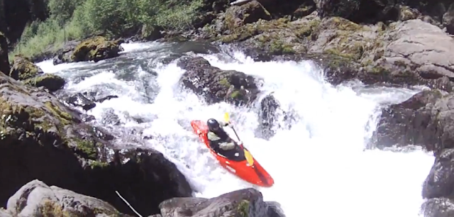
Jake Zwicke exits the O.K. Corral on a more recent 2017 trip.

Photo: Scott Baker
Middle Santiam Gauge @ 3.8'
After the OK Corral (a series of ledges leading into a 10-15' exit falls), scout the next tricky boulder garden on the right. After this boulder garden it's lots of read and run class III-IV, look for a creek entering on the right about a mile down (Lake Creek) with a small but tricky double drop you can hike up to if there is any water flowing down the creek.

More read and run eases off until Geomorph, where an active landslide on river right creates a series of rapids along a river-left cliff.
The first in the Geomorph series is the largest, and should be scouted.

This series of rapids continues downstream and parts may require scouts depending on flows and wood.

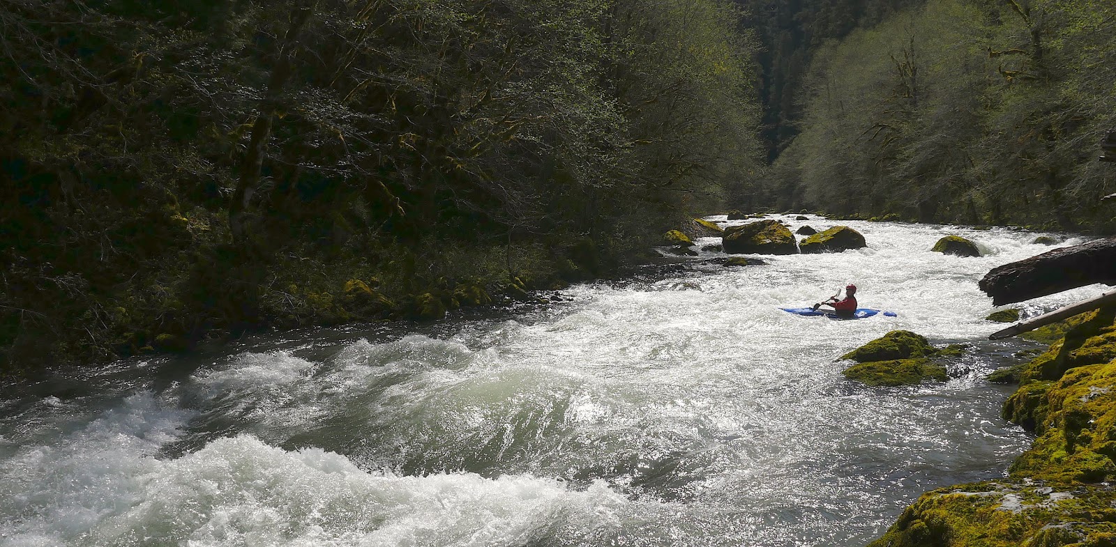
More read and run leads to Shedd Camp Shelter and Shelter Falls. As the levels come up, it's wise to be on alert above Shelter Falls. There is a section of boulder bars that ends in a gradual right turn abruptly at this drop, with a brushy eddy on the left (where the un-manned red boat is in the following photo) immediately downstream from where a creek enters on the left. If you are paying attention you will note the large boulders downstream and have time to make this eddy.
Scott Baker roosting Shelter Falls for his birthday.
Middle Santiam Gauge @ 3.8'

Photo: Zach Urness

The hardest drops are behind you at this point, with sustained stretches of read and run making up the rest of the trip. Below Shelter Falls one of these sustained sections of easier rapids begins, then ends again about the time Pyramid Creek enters on the right a short way after crossing under a bridge, which is nearly the same size as the middle Santiam at this point. The run takes on more of a river feel and becomes less creeky after this confluence.
Downstream of Pyramid Creek, a plethora of camping options exist, there are some decent ones early on, but the best ones are in the vicinity of Donaca Creek (which comes in on river right), about 1.5 miles below the Pyramid Creek confluence.
Jesse all smiles in the heart of the Middle Santiam Wilderness.

We camped immediately downstream of Donaca Creek and used it as a water source. This site had the luxury of getting sun in the evening and morning on our Spring run.

Camping options do exist downstream, but the big, open gravel and moss benches dwindle quickly below Donaca Creek.

Downstream of the boulder bars the stream consolidates again and enters the heart of the Middle Santiam Wilderness, this section defines scenic. The forest in here is green, even by western Oregon standards. The river moves along at the perfect pace through here in the form of mostly class II to III rapids (along with the occasional attention grabber), allowing you to take in what is around you without having to focus much on the rapids or making time. Do keep an eye out for wood though, it is likely to be present, though don't be surprised if you don't ever need to get out of your boat.
Eventually, a corner is turned and the transition from wilderness into private timber land is obvious. You may find your attention diverted from the greenery to the large cliffs visible high on the hills.

The whitewater picks back up with some read and fun, a little more exciting than the read and run that has come before. Nearly every rapid in this section has a good jib feature or two, the smooth rocks make for great boofs, splats, and eddy turns. Keep your eyes out for the occasional surf and the slalom opportunities as well.
This section eases off but the water keeps moving, over 4' there are no still pools so it's easy to make good time. Don't forget to grab a snack! There were newts everywhere both times I did the run, and the fishing is great if levels are low.

After some more cliff viewing, a final barrage of good whitewater begins. This is my favorite section on the river, everything is boat scoutable and clean. There is great mixture of friendly hydraulics, maneuvering, boofs, ramps and splashes.
Jesse gets a little of everything in this fun one.

This last section of whitewater continues for some time, and left a smile on all our faces. Finally, a bridge is reached near where the lake begins. If you figured out access to near here it's a short lake paddle to where the vehicles are, but if you left your rig at Whitcomb Park you have 6 miles of flatwater in front of you. Though chances are reasonable if the boat ramp is open, you might be able to bribe your way into a ride as motorized boat traffic on the reservoir for fishing is common.

While there is some good whitewater on this trip, there is also plenty of lazy floating between. A great mix for an overnight opportunity. The run can be done in a day, but with the long shuttle, long run and potential access hurdles I prefer to get the most time out of the run as I can on the rare opportunities that arise to paddle it. As the only true wilderness run in Oregon's Cascades, with few trails reaching the river, you can count on the only people you see on the river being the ones you paddle in there with.

Flows: The Middle Santiam has a foot gauge, but no cfs reading as of 2020. The first of the following graphs show the flow we had on an overnight trip at what I would consider goldilocks flows, not too high, not too low. The second graph was from my first time down when we did it as a day trip. The day trip was at the low end of enjoyable, but I'd go back at that flow if it was an overnight opportunity and bring a fishing pole. In 2017 two other groups did the run at 3.8' and 3.9' (May 20, 2017) and were satisfied by the level. The highest level I have heard of so far was 5.2 dropping to 5.0 (May 30, 2023) from Willy Dinsdale, he said that felt like a perfect medium-high.
Goldilocks Flows

Minimal Flows

You can also tinker around with the Inflow to Green Peter Reservoir to guess cfs. Soggy Sneakers recommends subtracting the Quartzville flow from the Green Peter inflow to get an estimate for the Middle Santiam. Using that calculation, 900 cfs was minimal and 1,200-1,500 was goldilocks.

Access: The first thing to do is look the local snotel sites to get a feel for whether the put in road will be accessible. The two closest are Jump Off Joe and Daly Lake. The access road is between those two reporting stations, and give a reasonable estimation as to how much snow will be on the road. The Sheep Creek road is prone to retaining snow drifts. The logging company does plow up there some years, and has been happy to let us know whether they have done that yet at (541) 367-2111. You can also try the local ranger district to find out the road conditions.
And if there is snow on the road, you could always try getting resourceful.

Take Out: The easiest take out to find is Whitcomb Creek Park boat ramp (44.477798, -122.507539). Using this take out requires a 6 mile flat water paddle out, though bribing a ride from a motorboat is often an option if the ramp is open. There is also a road on the other side of Green Peter Dam that goes all the way to the inlet of the reservoir, but is privately owned by a logging company. High Deck Rd out of Cascadia is owned by that same company. You can try and figure out those access routes if you want to reduce the reservoir paddle.
Put In (44.466549, -122.147259): Return to Hwy 20 and drive east about 24 miles to NF 2047/Sheep Creek Rd where you turn left. Follow this road 8.7 miles to a bridge over the Middle Santiam (stay right at 0.3, left at 0.4, center/main at 2.3, right but not hard right at 3.6, then stay left just after, right at 5.9, 7.9 and 8.4). The last few miles of the shuttle parallels the headwaters of the Middle Santiam
**If you don't like the look of the first gorge below the bridge (the O.K. Coral), there is a road on river left with an old spur leading close enough to the river that a short bushwhack can serve as an alternate put in.
**If you don't like the look of the first gorge below the bridge (the O.K. Coral), there is a road on river left with an old spur leading close enough to the river that a short bushwhack can serve as an alternate put in.

Photo: Willy Dinsdale @ 5.2'
From the Put In: Once you reach the bridge, walk 1/10th of a mile downstream on the road to scout the OK Corral from the ridge overlooking it.

----------------------------------------------------------------------------------------------------------------------------------------------
Original Write-up
Marathon on the Middle
----------------------------------------------------------------------------------------------------------------------------------------------
Marathon on the Middle
----------------------------------------------------------------------------------------------------------------------------------------------
The Middle Santiam is known as Oregon's only Cascade wilderness run. My attempts on the run have been thwarted for various reasons over the last few years so this time I was bound and determined to get in there. No one I knew seemed stoked on the trip so I loaded up my car with overnight gear, SPOT device and a scooter for shuttle. Lucky for me I got a call the evening before my trip from Lucas Glick who agreed to join me on the 20 some odd mile run if we could do it in a day as he wanted to get on the Clear Fork Cowlitz the day after. I unloaded my overnight gear and scooter and agreed to meet early the next morning.
To avoid the hike in and add in some adventure we planned to run the section the Oregonkayaking crew had uncovered a few years ago. This would add about 5 miles of exploratory kayaking to the run, but allowed us to put in at a bridge instead of doing a hike. We made good time on the shuttle and found the put in without undue difficulty.
The first hundred yards of the creek are the most stacked and difficult to scout so we hiked up a ridge to get a view of this section. Lines committed to memory, we got ready to get underway.
**If you don't like the look of this first gorge, continue just under 1 mile past the bridge over the Middle Santiam to the bridge over Lake Creek (flows out of a culvert). The 1/4 mile from this bridge to the confluence with the Middle Santiam has some issues, but everything is portageable and there is even a fun surprise or two waiting in there. **
I was geared up first and slid into the water. The first ledge was class two, I revoked my initial decision to go right when I noticed some obnoxious branches and went for the janky middle chute instead where I promptly pinned. I tried budging the boat for a minute before Lucas got there, we both tried for another minute but the boat didn't give an inch. I pulled my skirt and stepped onto a dry rock to my left. My boat stayed stuck for another minute before coming free.
Glad to get the carnage out of the way early we continued on downstream into the gorge. The first couple ledges went smooth, then I portaged a weird drop that Lucas ran before we both dropped off the fun exit falls.
The "OK Corral", It may be short, but it sure was exiting, yeeehaa!
Also a nod to the Oregonkayaking (OK) crew for pioneering this upper section and many other runs in the area. Boating in Oregon wouldn't be the same without them!


The next couple miles were nice but we didn't have enough water to fully enjoy the rapids. The area was super cool though! There was a tantalizing double drop coming in from a creek on the right that would have been good with more flow. The next major rapid I recall was created by a landslide coming in from the right.

Lucas seeks the shelter of the pool below.

MSantiamWilderness from Jacob Cruser on Vimeo.

The South Santiam@Cascadia dropped from 1,000 - 800 cfs that day after two days without rain.
Quartzville dropped from 700 - 550 that day.

Lucas about to exit the O.K. Corral via a nice 10-15' foot falls.

Below here was a tricky boulder garden that we both fumbled our way through.


The next couple miles were nice but we didn't have enough water to fully enjoy the rapids. The area was super cool though! There was a tantalizing double drop coming in from a creek on the right that would have been good with more flow. The next major rapid I recall was created by a landslide coming in from the right.
Geomorphology in action.
There were more rapids in this section before we came to Shelter Falls. This double drop is tough and I chose to portage. Lucas cleaned up though!
Shelter Falls.


The next stand out moment came when we were in cruise mode and I caught a micro eddy just above a malevolent logjam and had to climb back upstream. Second mistake of the day for me, I was not on top of my game. We scouted and the jam turned out to be runnable in the middle. Below here was a section that increased slowly in entertainment value before settling back to boulder bars.
I wish I remembered more but we were moving expeditiously. If I did the run again I would take two days to appreciate the area. I do recall an enjoyable class III-IV section with fun rapids that lasts for quiet awhile, ending near the reservoir. We stopped twice to fish and eat some food.

We paddled about a mile on the lake before being picked up by a motorboat.
After this we still had time so headed over to the Pure Hate gorge on Quartzville. That however, is a story for another day.
Video from the Middle Santiam Wilderness run.
MSantiamWilderness from Jacob Cruser on Vimeo.
Lucas and I paddled the run on June 1, 2013
The South Santiam@Cascadia dropped from 1,000 - 800 cfs that day after two days without rain.
Quartzville dropped from 700 - 550 that day.


