Thursday, November 19, 2015

Skamania Mines Creek


If you would ever like to add Skamania Mines Creek onto a day at Hagen, you may find the following access information useful.

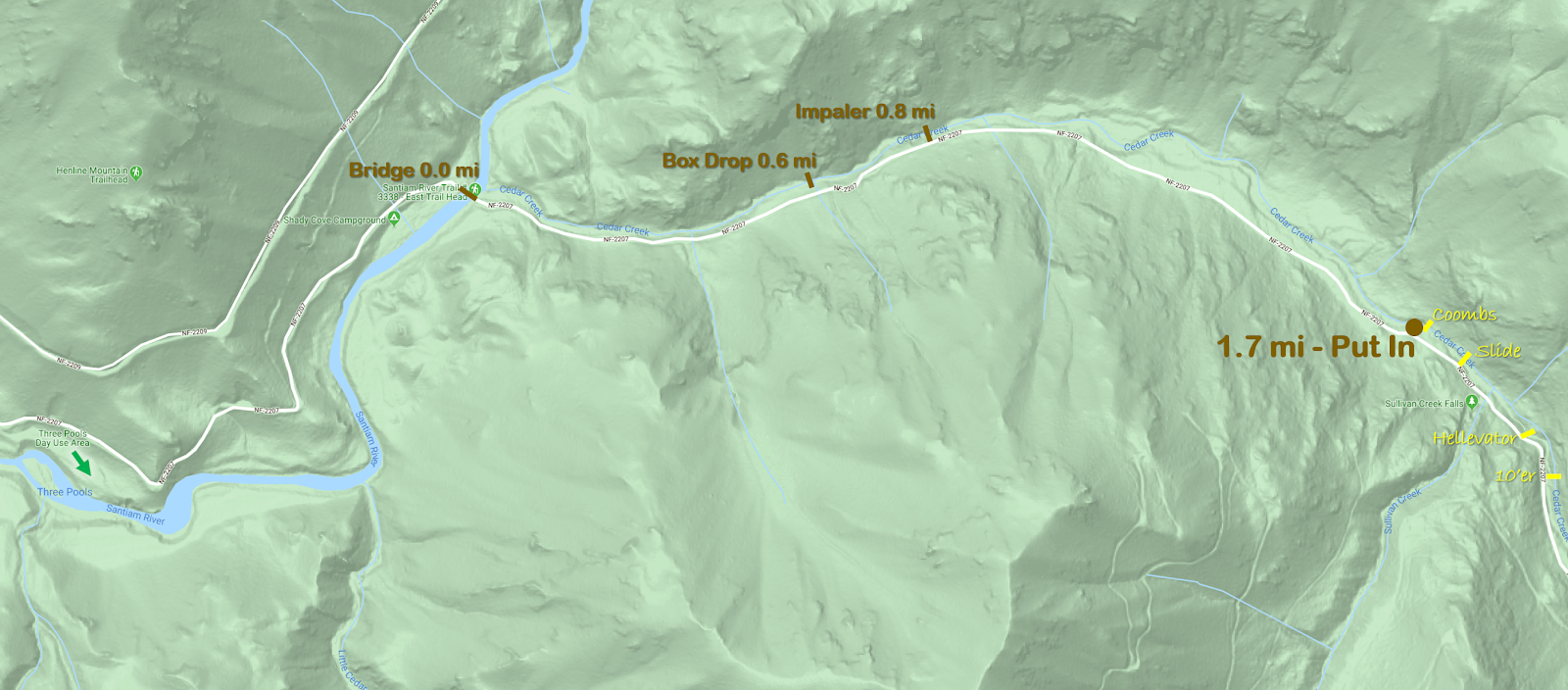
I would recommend parking here 45.7028, -122.2234.  This location is just barely over two miles past the road that leaves Skamania Mines Rd to access the Hagen put in.

Get into the older trees and follow the ridge line down to the creek.   The distance is the same as the hike into Hagen used to be before the new access was found, except that instead of a clear cut its mostly forest and ferns so the going is easier.

This hike drops you in right above the gorge (used loosely) on Skamania Mines Creek.  This gorge has a long set of bedrock ledges that stack up to create a rapid reminiscent of a longer and more involved Euphoria.


Park at the circle, walk where the line is to get just the good and avoid the wood.


The reason to put in here is the mile above the gorge is mostly wood portaging (walking along the bank is easy though) and blind class III corners, which we didn't feel was worth paddling.
We did not use the put in described above and found that in the mile above the gorge there was quite a few wood issues.

Ross putting in below the previous portage, and Ben getting to shore above the next one.

Nick and Priscilla were not impressed with the quality of the stream this high up and decided to walk out and save their energy for Hagen.


Less than a mile after putting in we reached an island, just below this island the creek turned to bedrock and produced a fun series of features that linked together into a good stretch of whitewater.  The alternate hike in would drop you right at the start of this bedrock.

Ross makes the first move as the bedrock starts up (just below the alternate access point).

Ross runs the next rapid that Ben signaled us through.  After catching an eddy on the right just below this rapid we went for an extended scout on the right.

Ben balancing on a submerged log at the crux of our scout (not necessary if you scout river left or high on the right).

This rapid turned out to be a fun multi-move rapid with some puffy hydraulics and fun boofs, we felt it was like a more involved and longer Euphoria.

It continues around the corner.

Ben nearing the end of the Gorge rapid.

Below this rapid we caught an eddy on the right to scout Mike's Slide, which had a couple more fun moves.

The eddy between the gorge rapid and Mike's Slide.

Ben cruising below Mike's slide.


 Just below Mike's Slide was a river wide tree, then the confluence with the NW Fork Washougal. Below the confluence we had no more wood issues.

Just below the confluence.

 From here to the take out bridge is just over a mile of fun class III-IV similar to other stretches of the NW fork with a hole visible from the take out bridge that is best run center-right.

Once the bridge is reached there is the option to take out, continue down the NW Fork Washougal, or do what we did and head up to Hagen whose put in is less than a half mile away.

Priscilla's first lap on Euphoria.

Ben gets gnarly at The Cracken.


We were there on November 14th and felt the flow was at a nice medium level.


Check out the story of the first descent from Oregon Kayaking.

   -jacob

Thursday, November 12, 2015

Cedar Creek


Photo: Priscilla Macy


BETA
2 miles, IV(V) with the option to put in higher for some V-V+


Stream: Cedar Creek used to have a notorious reputation as a fringe run, only for those looking to hairball down some class V+ with tiny eddies.  While you can pick off some large drops above the put in, there is also a roadside 2 mile section of nice class IV(V) that is verging on must-do for Willamette Valley boaters.

 Photo: Priscilla Macy


While Cedar Creek can be run on it's own, it combines well with a run on Classic Opal since it is easy to use the same take out at Three Pools.  From there it's just a short drive upstream to the bridge over the Little North Santiam at the Cedar Creek confluence.  Boaters can scope out the wood situation as they drive along Cedar Creek, there are usually a couple logs and some brush that need dodging.


 For how roadside it is, there are some beautiful spots on Cedar Creek.
 Photo: Priscilla Macy


Less than 1/4 mile upstream of the bridge is the campground ledge, where flows are checked.  Flow information is further on down this page.  1.7 miles after crossing the bridge at the LNF/Cedar confluence is the put in at a small pull out on the left.  If you make it to Sullivan Creek (a tributary with a big waterfall right next to the road), you have gone too far.  The put in is right at the base of Coombs (which you can glimpse from the road).   While most boaters will put in at the base of Coombs, boaters interested in V-V+ whitewater can check out the 1/4 mile upstream.  It's all roadside and the big drops are easy to scout.  If you are planning to run those drops, the whole section should be thoroughly vetted before tackling.  The eddy situation is sparse and the drops complex.

Hellevator, one of the big ones above the put in on Cedar Creek.


 Most people will skip the big stuff and put in at the base of Coombs.


Things start off with a short section of engaging whitewater.  After the first few rapids, things ease off for a bit and there is some mellow class II-III with a manageable amount of wood and brush to maneuver around.


One of the first fun rapids.

Things pick back up at Impaler, which comes just after passing a campground with a fence visible from the creek on river left.  Downstream the creek enters a straight away with a horizon falling back to the right at the end.  The eddy to scout/portage is on the left half way between the horizon and the sign in the photo below. 

Impaler is a two ledge rapid, the first is ugly and the second is good so most people choose to seal launch straight into the lip of the second ledge.  The second ledge can also be portaged with a seal launch a bit further down.  


A few more good class IV rapids separate Impaler from Box Drop, the second and final class V rapid.  Box Drop was also marked by a yellow sign in the trees on the left in 2020, just below a fun rapid with some offset hydraulics ending with what qualifies as a pool on Cedar Creek.  

Box Drop has been run both right and left, but also has an easy portage on the left. 
Ben does it right.


Some more read and run leads into the campground/gauge ledge, which is run center.


Then it's non-descript but steep whitewater all the way to the confluence, on both my runs we have hopped out once to scout down here.  Once on the Little North Santiam it's about 1 mile of boogie down to Thor's, which can be scouted along a trail on the right if flows are higher than you typically run Opal.

In 2020 there was plenty of wood and brush to be maneuvered around on Cedar Creek, but no wood portaging.  


Thorough scouting from the road beforehand makes the trip run smoother, as it's less likely stuff will sneak up on you.  While Impaler and Box Drop were signed in 2020, if you want to visually inspect the eddies before putting on you can do so 0.6 and 0.8 miles above the bridge at the LFN/Cedar confluence. 


Flows:  Use the Little North Santiam @ Mehama gauge to ballpark flows, keeping in mind it can make a big difference if flows are rising vs. falling.  We were there two days in a row to start off 2020 and the first day flows were higher than I would run the creek, with big holes and few eddies.  The second day flows were what I would call a perfect medium. Graph below.


Once at Cedar Creek, you can get a visual at the campground ledge, about 1/4 mile upstream of the Cedar/LNF Santiam confluence.


There are two rocks on the lip of the ledge that can be used to assess flows.  The one circled in blue needs to be covered for the creek to be worth paddling.  Perfect flows have just a tiny bit of water spilling up and over the rock circled in orange.  If there is enough water that you could potentially paddle over the orange rock, flows are high.  I personally would never paddle this creek high, as stopping would be a real challenge due to sparse eddies, it would be a high speed class V descent with wood in play.

Water over blue rock = enough water                                  Orange rock boofable = high water


High


 Perfect Medium.


Friendly and fun.


Access:  Take I5 to Salem and head East on Highway 22 towards Detroit Reservoir.  In about 22 miles turn left at a flashing yellow light onto N Fork Rd.  In about 15 miles the road turns to gravel, just under 2 miles after that turn right (there is a kiosk and some boulders at this location).  Just under a mile after turning right at the kiosks, pull right into the paved Three Pools Day use area (not signed).  Three Pools is the take out:  44.840457, -122.313914

Coming out of the Three Pools parking lot, turn right.  In about 1 mile you cross a bridge at the confluence of the Little North Santiam and Cedar Creek.  In another 1.7 miles is the small pull out on the left adjacent to Coombs, this is the put in.  If you are looking at the creek from the road you should be able to catch a glimpse of Coombs through the trees.  If you get to Sullivan Creek, you have gone too far.

If you are interested in the 1/4 mile of V-V+ above the put in, it is all roadside and can be thoroughly scouted.  That section starts with steep bouldery rapids leading into a ten footer that need to be run boofing right to avoid a rock in the landing.  A hundred yards of more steep boulder garden leads to Hellavator, which is reminiscent of a more challenging Gorilla.  More steep boulder gardens lead to a fun slide just below the Sullivan Creek confluence, you can exit the creek just below this slide on the left.  Right around the corner from that slide is Coombs, without any real eddies above it.  

Click on map to increase resolution.


----------------------------------------------------------------------------------------------------------------------------------------------
The Upper 1/4 mile
----------------------------------------------------------------------------------------------------------------------------------------------


Cedar Creek has quite the reputation.  When the report from Oregonkayaking for the upper section was written, the creek was still being utilized as a hair-boating destination.  

Those guys went back and ran the lowest mile a couple years later, which seemed like it would appeal to more boaters, but was pretty short.   

After a couple scouts and confirmation from Pete Giordano that it really wasn't all that bad I was set on trying it out at some point.

Last weekend we were floating by on Classic Opal and noted that Cedar looked like it was at a good flow.  Once we reached Thor's, it was decided that instead of doing the usual and continuing through Opal Gorge that we would pack up and check out Cedar.


We noticed a log portage a hundred yards above the confluence with a convenient trail up to the road just above so used that as our take out.  Continuing upstream we scouted the eddy situation for Box Drop, The Impaler, Coombs, and Hellevator at about .6, 0.8, 1.7 and 1.9 miles above the bridge near the take out respectively.  Fortunately all of those spots are visible from the road for those with a sharp eye.  


Ben Mckenzie and Brian Ward put in where Oregonkayaking put in, Brian Butcher and I put in at the confluence with Sullivan Creek.


Ben Mckenzie and Brian Ward warm up above Hellevator.


Neither of them were able to hit a boof on the first ten footer, but both were online and avoided hitting the rock that is deep in the center of the landing. They paddled some of the boulder garden downstream before climbing up to the road to get around Hellevator. Hellevator is like a stouter version of Gorilla on the Green River in North Carolina. The walk was easy along the road on the left, and we all put back in just above or below the Sullivan creek confluence.

Looking into Hellevator along the portage on the road.


 Just downstream of Sullivan was a fun slide, the best drop on the whole creek. I sent everyone down on verbal before joining in on the fun myself.

The Slide

Almost immediately downstream was Coombs, Brian Butcher portaged left just below the slide which was the thing to do. The rest of us portaged the ledge on the right, then ferried across to where Priscilla (who was providing ground support along with Sam Box) pulled us onto shore. This is the trickiest eddy situation on the creek, and really we all should have done what Brian Butcher did. Ben looked at Coombs seriously, but in the end decided to join the rest of us in the portage on the left. I feel Coombs looks better at higher flows, but is always on the V+ side of things. Very runnable, but stout.


Below Coombs we entered the normal run, and it was a good time making our way downstream. The run was consistently steep class IV, a few times we had one person hop out and send the rest through on beta. 


Priscilla and Sam helped us spot the eddies above Impaler and Box Drop, which was a big help as they sneak up. (2020 they are now signed).


The first tier of Impaler


Brian Ward finishes up Box Drop.

We skirted one log on the left and took out on the left just above a sign reading "One Lane Bridge".  

A good run, one I will certainly be back to.


We had flows peak at 1,200 cfs on the Little North Santiam @ Mehama gauge on (Nov 8, 2015) and thought we had a good level.


Gauge ledge


Just upstream of the confluence with the Little North Santiam the day we ran it.


-jacob

Thursday, November 5, 2015

Crabtree Headwaters: Of rumors confirmed


 I was looking over some maps a couple of years ago as I often do, and came across a steep section in the headwaters of Crabtree Creek.  This upper portion of the creek looked pretty small, but like it maybe had enough water to be a boatable stream.  Anna Herring and I went up there to scout out access last year and while access looked reasonable the stretch we paddled in our playboats (between the section I was interested in and the guidebook stretch) was low, of so so quality with an intriguing bedrock rapid right at the take out under the bridge that is used as a put in for the regular stretch.  Not long after I got in touch with Pete Giordano about the area as he tends to have run, scouted, or knows of people who have the streams of the Willamette Valley.  He said that he heard that there used to be a run in that drainage that was once a favorite among the Eric Brown/Dan Coyle crew out of Corvallis many years ago.  After further recon I began to believe that this section I was looking at could possibly be that run.

This year the rains finally arrived during hunting season and the gates that usually block access to the drainage were open.  I was surprised when 10 people showed up to gamble that these whisperings of a forgotten gem might be true. 

Boaters: Ben Mckenzie, Brian Ward, Emile Elliott, Susan Hollingsworth, Adam Elliott, Jesse Shapiro, Pete Giordano, Ross George, Priscilla Macy and myself (Jacob Cruser). 

Well I take that back, 6 people were there for that reason.  Two more were there to run the guidebook stretch downstream and two more thought they were there to run the guidebook stretch. 

After figuring out logistics the full crew drove to the put in, 8 of us geared up, said goodbye to Priscilla and Susan (who were doing the guidebook stretch) and did the short walk down the decommissioned road to the put in.  Pete took the correct route on the walk in while the rest of us spent a few extra minutes portaging down a tributary.


Once consolidated, we set up parameters for doing a a trip of this nature at healthy flows and set off downstream.

I think at this point Brian had caught on, but Ross still thinks we have put on to the class III guidebook stretch.

Fast and fun splashy rapids quickly built into class IV and we found ourselves running some good whitewater.  My suspicion that my creeking ability had degraded after months without rain was confirmed as I missed a pretty straight forward eddy and subsequently ran a rapid I had been told to scout without doing so.  We talked later on about how this was a fun intro to the season, though many of us wished we had been more dialed in!


More fun whitewater led to a horizon line with some wood visible.  Here the right wall was sliding into the river and a straight away with some challenging whitewater lead to a right hand turn.  A long scout from part of the team and it was decided that most of the us would make the portage on the right. 


The straight away.

The scout had revealed that at the end of the straight away the river turned right and entered a class V set of boulder gardens.  The rapids were big and there were no eddies in sight.  Ben and Adam decided they were confident they would find a way to stop before they found wood.  I watched them turn the corner into the rapid we later named Browntown for Eric Brown, who was the first to run so many of the creeks around here, including this one. I then helped catch the rest of the team along the bank one by one for the portage.

Brian in the straight away just before things get serious, planning to crash into the shore where this photo was taken so we can grab him for the portage.


 Ben arrives in Browntown.


Us portagers attained the treeline where the going was easier and returned to the river near the end of the 1/4 mile long set of rapids.  After reading and running some serious whitewater, Ben and Adam had indeed found a way to stop when they needed to in order to scout the final rapid in the set.  We had not seen them run the middle portion, but they described it in this way.

    Ben:  It is the hardest thing I have run in Oregon
    Adam:  It's similar to the stuff on the Upper Little White, but harder.


 Adam enters the last part of Browntown.


Staring down the final boulder jumble before things ease off.


Waiting while the team regroups a rapid or two downstream.


Ben and Adam linked every piece of whitewater aside from 20 yards that was mistakenly portaged, so gnar dudes could feasibly do the whole run without any portages if the take out just below Birgus is used.


More class fun waited below downstream.

 Par for the course.


Emile and Pete head downstream.


At the end of the challenging whitewater is the finale, a fun ramp into a right turn and over another small ledge.  Just above this drop, it appeared that an attempt had been made to divert the creek.  You can see where the diversion returns in the picture below.  Maybe in a number of years that will be the main channel?

Birgus - Named for the only crab known to climb trees.
Adam drops in on the unique ramp.  


Jesse is all smiles below Birgus.


 Things tapered down pretty quick after this, now the creek was a series of splashy III+ rapids.  There was one log portage that we easily walked on the left, the road is also close here so this location could be used as a take out. 


The mandatory log portage, it looks like it was cut down to make a bridge.

We bee-bopped downstream some more and came to a place where the stream had diverted into the woods where a unique portage ended up being our last.


After that it was splashy paddling to the take out. 


Jesse's smile had grown even more by the time we made it to the end.


Ross' emotions were less discernable.


Looking upstream from the take out bridge.


Flows from Pat Welches site, we were there on November 1st, 2015.  


2.3 miles long
280fpm
1/2 mile drops 200 feet.


-jacob