On June 21st, Nick, his brother Alex, and I drove to the Lewis river to camp and run some waterfalls. We got excactly what we were looking for with a great water level and a choice of a multitude of slides, ledges and falls. Nick and I drove up before Alex because he had a dentist appointment. On the way we scouted Rush Creek, which looked real steep.

Later that day we went to scout the take out eddy above upper falls that would make the portage around the nasty job infinately easier than the last time we were there. As we were pulling back into the campground after our scouting trip, we rounded a corner to see a car with boats on it. We parked quickly to see what they were doing. We got to the falls just in time to see one of them saddling up for the lower falls (five-footer into a fourty footer). He took a real good line, cleaning the drop but landing flat, he said that it was a pretty big hit even though the water was fairly airated.

Then we see one of his buddies set his boat next to the falls in seal launch form. We couldn't beleive that he was actually going to seal launch into the falls. Sure enough though, he pulled on his skirt and dropped in, completely melting into the falls about halfway down. He resurfaced upside down and was dragged into the cave behind the falls, a really bad place to be. He later said it was real difficult to breath even though he was upright just because of the spray. Ropes were thrown, including ours, but nooone could pull him out. He tried about seven times to paddle out, and on the final try just squeeked out. This boater turned out to be Rush Sturgeous, a pro I had heard of as a big waterfall guru. After seeing him have so much trouble behind the falls our hopes of running it started to dwindle. seal launching in

After a while Alex showed up and we headed to Twin falls to do a few laps on this forgiving twenty-five footer. Both Nick and I cleanded it three times while Alex filmed. I was pleased that this falls was still running this late in the summer. We then headed to bed anticipating the next morning.

Nick tucking Twin Falls

We headed upstream the next morning to put in above Taitnapum falls. We scouted it and saw some other boaters runnning it. We heard they were going to run Upper from a guy named John who was one of there buddies, but had forgot his gear. We dressed quick and put in, I decided not to scout the first twenty footer from river level to save time, I dropped off the left side and had a perfect line, then ran the next slide to set up safety for Nick. The only spot with enough water to get an IK down was the middle, so Nick plugged that great and we headed downstream. Below here was a couple iii-iv drops chisseled out of the bedrock. Then we eddied out above upper and scouted the lead in that we were refering to as Apocalypse because from the top it looked like the end of the world (it is obviously still part of Upper falls so Apocalypse is not to become its full time name). This drop is a four foot drop, into a slide, into an eight foot drop with a decently sticky hole in the middle. Nick and I went left and it was fine.
Apocalypse

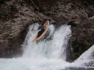
Nick decided not to run the next three foot ledge right above the nasty crack that we were portaging, while I ran it on the right, the eddy is plenty big, but if you miss your going over a class VI-ish drop backwards. We got our boats to the lowering point right as Ryan Scott was lowering his last buddy down. He offered us a helping hand and we slid down to a rock ledge right above the final drop in Upper Falls. We stood there for a second or two, then I helped Nick into his boat and into the eddy. He peeled out and had a perfect line down the falls with a great boof and tuck. I was then left up there to get in by myself. I slid in, but with noone to hold me in the eddy I came out before I was ready and had to fight to get towards my line, I ended up going a little farther right than I wanted to, but cleaned the falls in the end. I untucked my paddle before I landed and gashed my nose open on the cockpit of my boat. A small price to pay for such an awesome drop.
Myself midair.

After this was some easy water until we got to Middle falls. The slide on the right was so fun that we did it twice to get video. Some of the guys from Ryan Scott's group slid on there buts instead of running the falls. This one was so fun even Alex ran it:).

Then we buzzed downstream to watch the other group running lower. We got there to here that they decided to not run it. The fact that a pro kayaker and a group of very skilled boaters, along with my split nose helped me make my choice to portage. Nick however, spent a long time scouting, but in the end decided the cave wasn't worth the risk. All in all it was a great trip and we hope to return some day.
Here is the video, filmed almost entirely by Alex.

 On June 21st, Nick, his brother Alex, and I drove to the Lewis river to camp and run some waterfalls. We got excactly what we were looking for with a great water level and a choice of a multitude of slides, ledges and falls. Nick and I drove up before Alex because he had a dentist appointment. On the way we scouted Rush Creek, which looked real steep.
 Later that day we went to scout the take out eddy above upper falls that would make the portage around the nasty job infinately easier than the last time we were there. As we were pulling back into the campground after our scouting trip, we rounded a corner to see a car with boats on it. We parked quickly to see what they were doing. We got to the falls just in time to see one of them saddling up for the lower falls (five-footer into a fourty footer). He took a real good line, cleaning the drop but landing flat, he said that it was a pretty big hit even though the water was fairly airated.
  Then we see one of his buddies set his boat next to the falls in seal launch form. We couldn't beleive that he was actually going to seal launch into the falls. Sure enough though, he pulled on his skirt and dropped in, completely melting into the falls about halfway down. He resurfaced upside down and was dragged into the cave behind the falls, a really bad place to be. He later said it was real difficult to breath even though he was upright just because of the spray. Ropes were thrown, including ours, but nooone could pull him out. He tried about seven times to paddle out, and on the final try just squeeked out. This boater turned out to be Rush Sturgeous, a pro I had heard of as a big waterfall guru. After seeing him have so much trouble behind the falls our hopes of running it started to dwindle. seal launching in
 After a while Alex showed up and we headed to Twin falls to do a few laps on this forgiving twenty-five footer. Both Nick and I cleanded it three times while Alex filmed. I was pleased that this falls was still running this late in the summer. We then headed to bed anticipating the next morning.
 Nick tucking Twin Falls
 We headed upstream the next morning to put in above Taitnapum falls. We scouted it and saw some other boaters runnning it. We heard they were going to run Upper from a guy named John who was one of there buddies, but had forgot his gear. We dressed quick and put in, I decided not to scout the first twenty footer from river level to save time, I dropped off the left side and had a perfect line, then ran the next slide to set up safety for Nick. The only spot with enough water to get an IK down was the middle, so Nick plugged that great and we headed downstream. Below here was a couple iii-iv drops chisseled out of the bedrock. Then we eddied out above upper and scouted the lead in that we were refering to as Apocalypse because from the top it looked like the end of the world (it is obviously still part of Upper falls so Apocalypse is not to become its full time name). This drop is a four foot drop, into a slide, into an eight foot drop with a decently sticky hole in the middle. Nick and I went left and it was fine.
Apocalypse
We headed upstream the next morning to put in above Taitnapum falls. We scouted it and saw some other boaters runnning it. We heard they were going to run Upper from a guy named John who was one of there buddies, but had forgot his gear. We dressed quick and put in, I decided not to scout the first twenty footer from river level to save time, I dropped off the left side and had a perfect line, then ran the next slide to set up safety for Nick. The only spot with enough water to get an IK down was the middle, so Nick plugged that great and we headed downstream. Below here was a couple iii-iv drops chisseled out of the bedrock. Then we eddied out above upper and scouted the lead in that we were refering to as Apocalypse because from the top it looked like the end of the world (it is obviously still part of Upper falls so Apocalypse is not to become its full time name). This drop is a four foot drop, into a slide, into an eight foot drop with a decently sticky hole in the middle. Nick and I went left and it was fine.
Apocalypse
 Nick decided not to run the next three foot ledge right above the nasty crack that we were portaging, while I ran it on the right, the eddy is plenty big, but if you miss your going over a class VI-ish drop backwards. We got our boats to the lowering point right as Ryan Scott was lowering his last buddy down. He offered us a helping hand and we slid down to a rock ledge right above the final drop in Upper Falls. We stood there for a second or two, then I helped Nick into his boat and into the eddy. He peeled out and had a perfect line down the falls with a great boof and tuck. I was then left up there to get in by myself. I slid in, but with noone to hold me in the eddy I came out before I was ready and had to fight to get towards my line, I ended up going a little farther right than I wanted to, but cleaned the falls in the end. I untucked my paddle before I landed and gashed my nose open on the cockpit of my boat. A small price to pay for such an awesome drop.
Myself midair.
Nick decided not to run the next three foot ledge right above the nasty crack that we were portaging, while I ran it on the right, the eddy is plenty big, but if you miss your going over a class VI-ish drop backwards. We got our boats to the lowering point right as Ryan Scott was lowering his last buddy down. He offered us a helping hand and we slid down to a rock ledge right above the final drop in Upper Falls. We stood there for a second or two, then I helped Nick into his boat and into the eddy. He peeled out and had a perfect line down the falls with a great boof and tuck. I was then left up there to get in by myself. I slid in, but with noone to hold me in the eddy I came out before I was ready and had to fight to get towards my line, I ended up going a little farther right than I wanted to, but cleaned the falls in the end. I untucked my paddle before I landed and gashed my nose open on the cockpit of my boat. A small price to pay for such an awesome drop.
Myself midair.
 After this was some easy water until we got to Middle falls. The slide on the right was so fun that we did it twice to get video. Some of the guys from Ryan Scott's group slid on there buts instead of running the falls. This one was so fun even Alex ran it:).
 Then we buzzed downstream to watch the other group running lower. We got there to here that they decided to not run it. The fact that a pro kayaker and a group of very skilled boaters, along with my split nose helped me make my choice to portage. Nick however, spent a long time scouting, but in the end decided the cave wasn't worth the risk. All in all it was a great trip and we hope to return some day.
Here is the video, filmed almost entirely by Alex.
Then we buzzed downstream to watch the other group running lower. We got there to here that they decided to not run it. The fact that a pro kayaker and a group of very skilled boaters, along with my split nose helped me make my choice to portage. Nick however, spent a long time scouting, but in the end decided the cave wasn't worth the risk. All in all it was a great trip and we hope to return some day.
Here is the video, filmed almost entirely by Alex.