Stream: Lawson Creek is another tributary to the Illinois River I have had my eye on for awhile. We had planned and failed to run this creek a few times, but after getting some solid beta from Sean Bowen we really had the bug and made it happen the next weekend. Sean not only hiked in to check out the access trail and take photos of the level (no gauge on this run), but got us in touch with his friend Jim who agreed to run our shuttle!
We ran Woodenrock Gorge and the top section on the South Fork Coquille the day before Lawson, and were almost stymied by a log blocking the road we were planning to use. Despite the best effort of some locals, it wouldn't be clear for a few more days.

We had put enough effort into planning for Lawson that we didn't want to give up. I looked on the Gazetteer and saw three alternate routes. One was a long shot due to snow and lots of recent windfall, another we had just been told by a local had too much snow to get his 4 wheeler through, and the third was a 4 hour detour.
We went for the long shot, expecting at every corner to find a landslide or tree blocking the road, then as we climbed, a snow drift. The only things of note we found was this neat little roadside grotto and a multitude of waterfalls also visible from the road.

45 minutes later we were back on track and headed to Lawson Creek! We camped that night at Agness Bar where we were planning to use the pay phone to get in touch with Jim the next morning.

As it turns out the payphone has been out of commission for a few years now, but the camp host was friendly and offered to let us use his phone. The only problem he told us is his phone only works for local calls. This was just fine for us, since Jim is as local to the area as it gets!
We met Jim at Oak Flat, the take out for Lawson Creek, and headed up towards our put in at the Fry Place. During the shuttle Jim gave us some good intel about a time he hiked up the creek from the bottom. He had gone a mile or two before being turned back by a small waterfall with vertical walls. This added some trepidation to the trip, but we felt confident we would be able to deal with it since he said it was no more than 10' tall and that he actually hadn't really tried very hard to climb around it. Part way up the shuttle route, a family waved us down and told us the road was blocked a couple miles up by logging. Having come this far, we were not going to turn around without seeing for ourselves. A couple miles later we came to the operation where heavy machinery was being used to clear debris from the road, the operators moved their vehicles and waved us through with a "hang loose" sign. There were a couple turns past this point I had brought a map to figure out, but Jim knows the area well and he took us right to the spot.

We geared up and Jim checked out the ridge and Fry place, he gave us some more intel on what might be the best route to drop in on and where the trail used to be. He watched us from a ridge line and we waved every now and then along our descent.
Eventually I could no longer see him on the ridge and my mind shifted focus to the creek, where the rapids were looking more difficult than I had expected them to be at this point. The final drop down to the creek had some poison oak, and neither of us came away clear from that on this trip. Next time I would take a slightly different course I describe below in the access section.
Getting close.

Priscilla and I talked about the challenge of the rapids at the put in and what that might mean about the rapids downstream. She was nervous, and I was nervous for her, but we both decided we were ok with the situation. Optimism won out and we pushed off into the first set of rapids, and committed to whatever it was that was going to come down-river.
GoPro, making interesting rapids look like class III since 2002.
Around the corner we get out of our boats to scout a narrow pinch between boulders. There are plenty of boaters who would have likely chose to run the drop, we chose not to. The next drop looks more our taste, it has an undercut but also a controlled line will keep us clear of it. We go one at a time and have clean lines, moving downstream the gradient eases to what I expected at this stage in the game along with our nerves.
The last rapid in the first set, with the pinch rapid in the background.

Read and run class III+ continues until a ledge appears on a right turn. It looks kinda ugly from above, but turned out to be straight forward and clean.

Below here comes the meat of the run, we turn to the left and the river again drops away between boulders, from above I assume we will be portaging. A quick scout and the rapid turns out to be clean and fun. I go first and weave through, catching an eddy above what appears to be an ugly rapid, but it turns out to be pretty clean. This becomes a bit of a theme for the trip, rapids that look trashy from above have fun, clean IV-IV+ lines with the exception of the pinch we portaged early on.
The beginning of Saturation Station, where a rock flow with the consistency of jello comprises the left wall, with a longer rapid at the base.

Boulder gardens of much variety make up the majority of the run. One of the earliest, with an active rockslide on the left, marks the longest of them. While we were there, the bank looked stable but was in fact so saturated that stepping on it we resulted in us sinking through what appeared to be rocks. Bizarre! We later learned from Aaron Zettler-Mann that this is Blue Goo, which is abundant in Northern California and in parts of Southern Oregon.
The bottom of Saturation Station, a rapid at the base of a soggy rock flow.

The rapids up here mostly have a consistent style, yet with many different kinds of moves. We scout a fair bit as its hard to tell if the rapids are going to be clean from above, but they all are. There are a couple plucky holes hiding in there too, though we are always able to find a line through the soft parts of them.

After a number of quality boulder gardens, one of them ended in a bedrock pinch at the entrance to a gorge that lasts for about a mile. There was an unfortunate log just past the pinch that sent us portaging on the left. In hindsight the rapid could have been run into an eddy on the right, and the log easily moved. Oh well.
Shoulda, woulda, coulda.

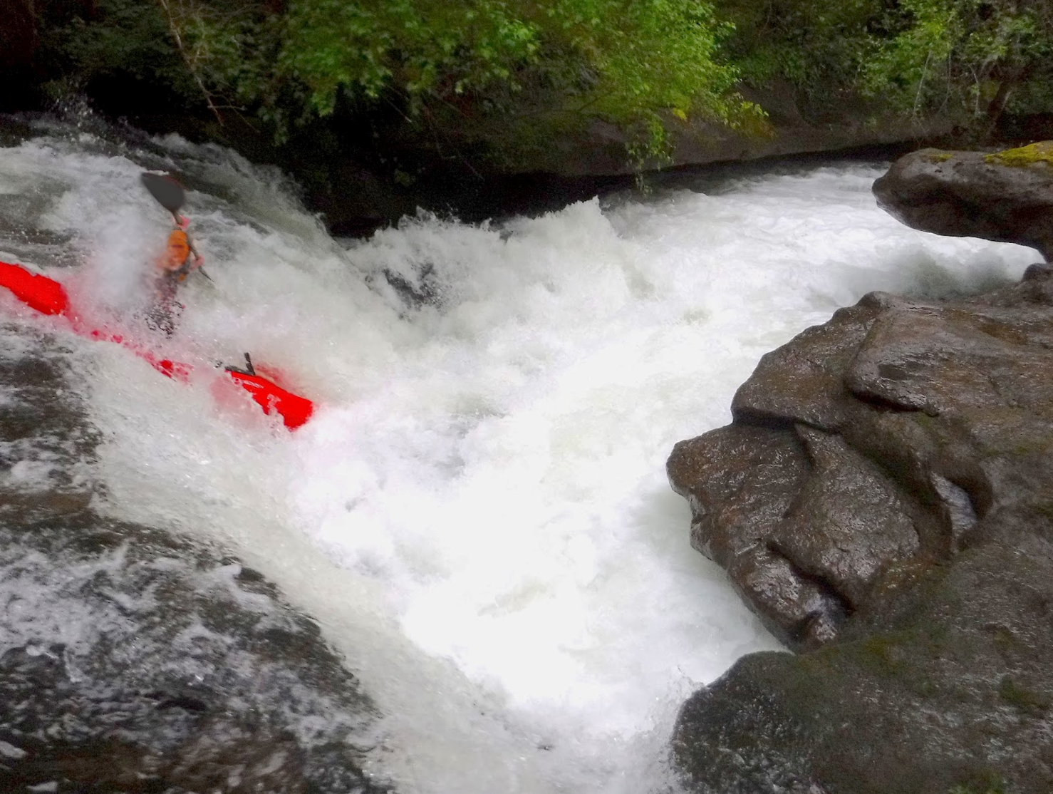
The run changes character here as it enters the gorge. The rapids are of similar challenge but a different style. The stand out rapid inside the gorge is Jim's Waterfall, a 5 foot drop (it filled in with the water) with a hole that needs to be boofed.
Jim's Waterfall


Eventually the run tapers off and the gorge is left behind, we had about 20 minutes of easier floating in which to reflect on the trip before reaching the confluence with the Illinois.

Photo: Nicole Smedegaard, from a trip in 2021
Paddling across the Illinois delivered us to the take out at Oak Flat where our vehicle was waiting for us. Heading towards Gold Beach, we find our favorite beach campsite unoccupied. Goals met, all that remains is a leisurely drive back home the next day, mostly along the coast.

I look back on this as one of the more enjoyable class IV-V runs in Oregon. A weekend combining Lawson Creek with either Lobster Creek and the Elk River or the South Fork Coquille is well worth the drive from the Willamette or Rogue Valley's.
Flows: The pictures from this report were taken March 31, 2017. If you run it with more water, you can expect a harder run. Inversely, with less water more rocks. Also note the gauges listed below are correlations and will not always represent the flow in Lawson.
 *Another group ran Lawson March 20, 2021 with flows on the Chetco capping mid-day at 4400, and reported slightly more water than Priscilla and I had on our trip.

*The group that ran Lawson in 2021 had 1400 in the Illinois @ Kerby, but more water in Lawson than we had.
Access: Take out at Oak Flat (42.5488, -124.0547), less than a mile upstream from the confluence of the Rogue and Illinois Rivers and but a few hundred yards upstream of Oak Flat campground. This is the same take out that is used for the Illinois River.
Put in by walking down steep, but mostly open terrain from the Fry Place (42.4926, -124.0981), Reach the Fry place from the take out using these directions: Return to Agness Rd, turn left and quickly cross over the Illinois River. 8.7 miles after crossing over the Illinois, turn left onto NF - 3318 (marked by a sign in 2017). Follow 3318 for 5.8 miles to an intersection, continue straight and downhill. 1 mile later veer right onto a spur road (122), if you don't have AWD and clearance don't push it on this road. So regardless of whether you are hiking or still driving at this point, continue just shy of a mile down the road (the "main" one) until it bends sharply to the right and levels out with a nice field downhill to the left.
Gearing up at the Fry Place.

There was a fire line that went off along the ridge here, you can follow this ridge past a lake and down to the stream. It might take a couple rope lowers, but in a little over half a mile you will be at the creek.
*There is a trail just to the east of the Fry Place marked on some maps in this area (1173), which was passible in 2021. This route is longer, but an easier grade and no off-trail navigation required.*


I look back on this as one of the more enjoyable class IV-V runs in Oregon. A weekend combining Lawson Creek with either Lobster Creek and the Elk River or the South Fork Coquille is well worth the drive from the Willamette or Rogue Valley's.
The Chetco gauge.
It's not perfect, but as time has shown, more useful than the Illinois gauge.

The Elk River Gauge (541-332-0405) was at 4.4' the day we ran Lawson.
Probably more confusing than helpful, we had about 3k in the Illinois at Kerby when we did Lawson. This gauge is only useful when storms make it over the mountains into the Illinois Valley, not always the case.

*The group that ran Lawson in 2021 had 1400 in the Illinois @ Kerby, but more water in Lawson than we had.
Access: Take out at Oak Flat (42.5488, -124.0547), less than a mile upstream from the confluence of the Rogue and Illinois Rivers and but a few hundred yards upstream of Oak Flat campground. This is the same take out that is used for the Illinois River.
Put in by walking down steep, but mostly open terrain from the Fry Place (42.4926, -124.0981), Reach the Fry place from the take out using these directions: Return to Agness Rd, turn left and quickly cross over the Illinois River. 8.7 miles after crossing over the Illinois, turn left onto NF - 3318 (marked by a sign in 2017). Follow 3318 for 5.8 miles to an intersection, continue straight and downhill. 1 mile later veer right onto a spur road (122), if you don't have AWD and clearance don't push it on this road. So regardless of whether you are hiking or still driving at this point, continue just shy of a mile down the road (the "main" one) until it bends sharply to the right and levels out with a nice field downhill to the left.
Gearing up at the Fry Place.

There was a fire line that went off along the ridge here, you can follow this ridge past a lake and down to the stream. It might take a couple rope lowers, but in a little over half a mile you will be at the creek.
*There is a trail just to the east of the Fry Place marked on some maps in this area (1173), which was passible in 2021. This route is longer, but an easier grade and no off-trail navigation required.*
Click to enlarge map

If you decide to run Lawson Creek, take poison oak precautions. There is a lot of it on this run.
-jacob