A photo drop from my recent visit to Wiki Creek 1.
This one is really destined to be a classic given it's quality, low elevation, and proximity to portland. If you like long complex boulder gardens, you're in for a treat.
Steve and Dan along The Great Wall
This rapid was left un-run on the first decent.
Steve cruising the crux of Smokin Aces
About half-way through the goods. Everything you see in the background is completely clean and very full on.
Stream: After a messy and steep bushwhack down to the creek (maybe 15 minutes?) you arrive at the creek. The first 1/4 miles is on the manky side and while you want to keep an eye out for wood there usually are no portages. It is important not to be too aggressive on this run, the first rapid (Catalyst) comes up quick and has been run blind on accident. It is at the end of a bit of a straight away with a busy class III approach. If you sense bedrock eddy out on the right ASAP and walk down the bank to scout this 15' ramp followed by a 6' ramp. Lucas Reitmann approaches Catalyst. Notice where the boats are on shore, well upstream of the drop. Once you see the horizon line, it's too late to stop.
Photo: Joe Kemper
The pool below Catalyst empties into the lead in to Osmosis. So get out in the pool below Catalyst to scout Osmosis which goes around the corner. The lead in starts as a series of small slides, then turns right and enters a narrow alleyway. This alleyway culminates in a beautiful 30' falls. Scout thoroughly on the right, if you decide to portage, schwack along the rim of the gorge until you are looking down at a grove of ferns descending to the stream and can see a small falls cascading off the cliff on the right downstream. If you drop down too early the descent is more difficult and you will run into Devil's Club. It is easy after the portage to walk up the bank to the pool below Osmosis for safety and media.
Photo: Nate Pfiefer A short gorge section leads to the lip of Tough Luck, a nasty 30 footer with numerous problems. If it was wood free it would be runnable but still V+. My first time doing this creek Jeff Hartley and I did a throw and go off the right side, but the landing zone is very small and at healthy flows it would be easy to lose boats here. Since that first trip I have always portaged left by doing a sloppy climb up the wall and then roping boats up after. Everyone after the first climber can then use the rope for assistance (recommended). Below here there is only one good place to descend back into the gorge and it's not too obvious. It's a steep draw overlooking Tough Luck and requires roping boats down and I usually double up a rope to assist my descent as well. Once below the first pitch it's an easy walk down to river level at a gravel bar above the next falls, Little Lucky. Little Lucky can be scouted easily from the lip on the right, and if need be portaged high on the right (only necessary if wood is present). This 15' drop has two obvious lines, both are clean but I like far right best. Below here is a short bit of semi-blind class IV, when it doubt run right. The tough stuff is over at this point and the difficulty of the whitewater quickly fades with the gorge. The left wall is worth paying attention to for the next mile as the marine deposit retains its grandeur but goes from a hard stone wall to a softer, sandier material the further downstream you go. The whitewater is unremarkable and is manky if flows are low but it keeps moving along. Near the end the walls disappear and there may be an easy log portage or two. The runout is pretty long so if you are running short on daylight keep that pedal to the metal. This isn't a classic whitewater run, but it's absolutely worth it and definitely a classic adventure run. Osmosis Falls may be one of the finest rapids in Oregon.
If you are still feeling fired up at the end, keep your gear on and check out Falls City Falls again on your way out.
Flows: Pat Welch has an online estimate,
I usually look for 400-900 cfs with some buffer room (Iv'e gone as low
as 200) for this section if flows are stable or dropping. I avoid this
river if flows are spiking.
When I get to Falls City I take a look at Falls City Falls to gauge flows for the run, located here: 44.867172, -123.438568
There are three rocks at the falls that can help you get an idea what kind of flows you have. - If flows are going over the yellow (L) rock, you have enough water to paddle the river. - If water is going over the blue (M) rock, you have good/medium flows. - If water is going over the orange (H) rock, you have high water.
Too Low
Runnable Low
This was taken at the lowest flow the gorge has been run, here is a video of Osmosis on that day.
The runout can be a bummer at low water.
Photo: Adam Edwards
Medium
Here is a video from a healthy medium flow.
High
I am not sure if it has been run this high, though I know the Lucas's (Glick and Rietmann) ran it pretty high once when they lived in Corvallis. At the flow they were there they needed to portage Tough Luck from well upstream of the usual spot, keep that in mind if you want to push flow limits on this one. I choose to stay away from this river if it's spiking, as it comes up fast, and there is always wood present.
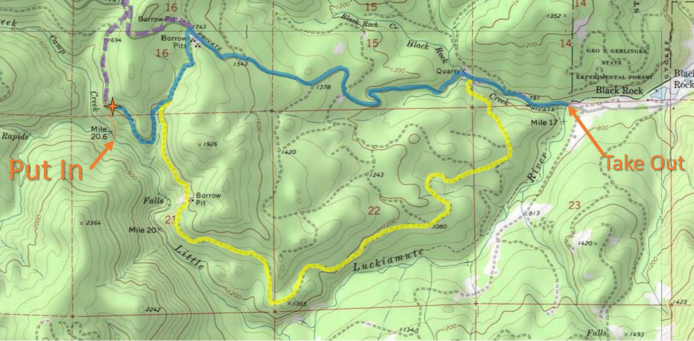
Access: It is highly recommended you cache a map on your phone and bring it with you on the shuttle/hike since the road system is confusing and ever-changing. At the very least bring a paper map.
Take Out: 44.869472, -123.510332
Put In parking: 44.869174, -123.556270
Driving into Falls City on Falls City Rd, you will pass the school and just as you reach the end of town stay right (left would take you over a bridge). In 1/4 mile veer left onto Black Rock Rd, the road turns to gravel. Follow Black Rock Rd 3.5 miles to a bridge and a white gate, passing by Camp Tapawingo and the world famous Black Rock Mt Biking area. The bridge with the white gate is the take out. **Whether the gate is open (on weekends during the hunting season) or closed (the rest of the time) dictates whether you are driving or hiking.** Photo taken during hunting season Oct 2016 at the take out bridge.
There are three main routes to get to the put in, they are delineated by color in the following map.
The Little Luckiamute travels from West to East
Click image to magnify
And some details from the put in area.
I like this route when hiking in through the clear cut. Start down the
dominant ridge, then cross left to the secondary ridge when reasonable
and follow that to the stream.
BLUE (3.3 mi): This route is the most direct, but it's steep and high profile
as most of it is on the Black Rock Mainline. From the take out stay on Black Rock Mainline for 2.3 miles before making a left onto a small spur road, 0.4 miles later make a right onto a very small spur. Half a mile later park and begin the hike down.
YELLOW (4.5 mi): This route is the longest, but much less steep and
lower profile so I prefer it for hiking and really it is best to drive
this road to minimize visibility. There is nothing illegal about
kayaking back there, and keeping a low profile is a great way to keep it
that way. In February 2019 the bridge over Black Rock Creek was washed
out, within 100 yards of leaving Black Rock Mainline, so it was not
possible to drive this route. Work is being done to restore the bridge.Cross the bridge at the take out and turn left in 1/2 mile. Continue 3.6 miles and always choose the main/flattest/most straight option (don't go into the
helicopter camp).
PURPLE (4 mi): If you miss the spur road off Black Rock Mainline, you can catch the next left to get to the put in.
*It's also possible to take a route on the other side of the river using Valsetz Rd, then hiking Fanno Peak (gated) to a spur to a bush whack that people have taken when the gate was closed, but I'm not going to explain that route here.
I had run this creek twice before, and hiked in a couple other times to scout. After the first time I always knew I would return with the intention of running a beautiful 30' waterfall that was almost run blindly by Jeff Hartley on our first attempt of the creek. That first time we were racing against darkness and had no time for a mishap or even to thoroughly scout the falls, sending us off into the woods for the portage. The second time I returned, the water was low. That second trip was about setting up ropes and scoping the run out for a return trip to run the falls with more flow and a softer landing.
On another trip Nate Pfeifer, Willy Dinsdale, and Brandon Bloomquist took me up on the idea to go back and check out the falls with the intent of running it.
We scouted the falls for awhile before Nate and Brandon decided to set safety for us, instead of running the falls which has a discouraging rock ten yards above the lip (gone in 2016).
I was concerned about the hit due to my tuck only making occasional appearances, but I really wanted to run the drop so decided to practice some mind over matter. The lead in is a bit tricky so I was happy when my line went how I had envisioned. I watched Willy have a great line as well only a few moments later making for a rewarding experience on the whole.
The team enjoys a special place!
(Photo Nate Pfeifer)
Nate Pfeifer did a write-up on the creek that can be viewed here.
2016 Update: Catalyst and Osmosis are clean, the rock that was a nuisance just above the lip of Osmosis has rolled over and the alleyway leading into the falls is more straight forward as a result.
The following videos show the new configuration at Osmosis (0:50), and were taken at the best flow I have run the Little Luckiamute.
This one also shows an alternate portage route at Tough Luck (3:00)
The wood situation was pretty good in 2019, just a couple easy portages in the class II-III stretch below the gorge. The gorge was clean aside from Tough Luck.
Each year is different on this one as the levels get high, so wood cleans up or can land in bad places year to year. I suppose that is all part of the adventure that is the Little Luckiamute.