BETA
Stream: The Deschutes River upstream of Bend has some great whitewater at a time of year when the rest of the Pacific Northwest is drying up. As the Summer gets into full swing, water is needed for agricultural purposes, so water is released from Wickiup Reservoir into the Upper Deschutes. This bumps flows up to around 2,000 cfs and turns what is already a nice run into something even better. The only downside to this run is the flatwater, between each section of whitewater lies quite a bit of it.
The uppermost rapid is called Benham, it is also the hardest rapid on the run. Because it is at the top, and because it is challenging and hazardous, it does not get run very often. However, putting in at the base of Benham gives paddlers half a mile of fun III+ whitewater before easing off to flatwater for the next 2 1/4 miles to the next whitewater at Dillon Falls. Because of this flatwater, if paddlers are not interested in Benham, putting in at Dillon Falls is a more common option.
Scotty Baker and Matt King taking a Dynamic Duo through Benham Falls.
As I heard it, they didn't want to do a practice roll before hand, as they wanted to have some beginners luck in their back pocket.
Dynamic Duo Benham Falls from baker scott on Vimeo.
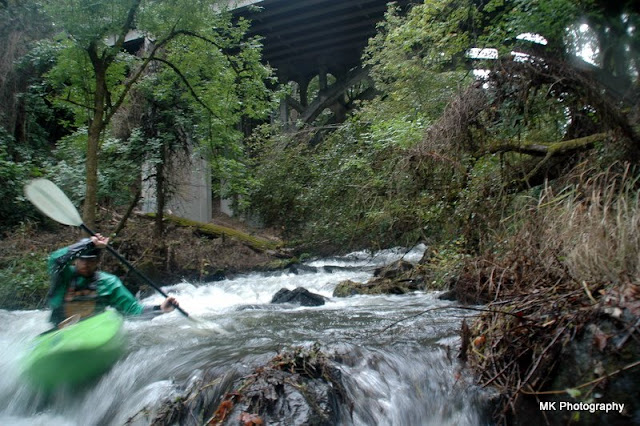
At Summer flows, Dillon Falls is one of the best rapids in Oregon. If you put in here, you can either walk down from your cars to scout the rapid along a trail on river-left, or paddle down to an eddy on the left just before things turn from class II to spicy (obvious horizon line). The standard line in the summer is to enter down a ramp on the left, then boof off one of three humps. There is another option to run down the far right, though it is more challenging. There is an exploding wave-hole over there that is noteworthy just above the lip. The center of the falls is to be avoided at Summer Flows, as it creates a powerful U-shaped hydraulic.
Dillon Falls
[IMAGE]
Regardless of how the falls is run, the next obstacle (the Dill-hole) comes up quick. The Dill-hole has a good seam on the left to shoot for, the center is liable to give you a surf. Downstream are a couple eddies on the left that heads up boaters can catch, before entering Dillon Canyon, a 300 yard long rapid reminiscent of the NF Payette. The crux is the first move, where the cleanest line starts left (to avoid a flippy diagonal on the right), threading over to the right on the back of the flippy wave to avoid another flippy hydraulic on the left.
Dillon Gorge
[IMAGE]
Below the crux, the line is typically down the right into an eddy on the corner, there is also a big boof in the center of the river if you want to spice things up. Coming out of the eddy on the right, ferry back to the far left to avoid a sticky hole on the center-right. Below this hole is some splashy water into a long pool. Better than memorizing these moves or trying to figure it out in person, is to follow someone down who knows the deal. The old internet/GoPro scout goes a long way on this river too.
Between the rapids, you can expect your fair share of this. Note that the smiles from Dillon Falls are still there.
After 1 1/4 miles of flat water Big Eddy is reached, a fun III-III+ rapid that last for half a mile. There are some fun eddies to grab, and some hydraulics to hit. Locals sometimes do laps on just this rapid to build skill sets and as an after work option as it's easy to walk back up via a trail on the left.
A half mile of moving flat water separates Big Eddy from Lava Islnd, which can be scouted on the right. Lava Island is actually a section of whitewater on it's own, with three rapids and some splashy stuff. The first rapid is Lava 1. Lava 1 starts with some twisting/boiling stuff that can be run right or left, followed by a bottle neck with holes on the side before splitting into two channels. The right side is a sloping ramp into a hydraulic that can be passed by right or (more commonly) left.
Priscilla passes by on the left
The left channel consists of a ramp, followed by a sticky ledge hole that can be boofed over, or passed on the left. The two channels quickly reconvene, and there is a nice eddy to regroup in on the right. Downstream is Cut-up, a great class IV rapid that can be read and run, Iv'e typically started center-left. Some splashy water and a pool lead to Lava 2, which involves a classic big-water left to right move. The typical line starts left, then as soon as a large diagonal is passed turn on the burners and drive right to avoid a large hole on the left (has been boofed over succussfully, but can also swim you). There is a large boulder on the right many boaters use as a marker, getting as close to that as possible before going over a ledge adjacent to the large hole center-right. Upon landing the current will move you back to the center of the river, this is desirable as there is some debris on the bottom right. A class III+ run out leads to another pool.
The hardest whitewater is over at this point, but the most sustained section is still to come. After 1.5 miles of flat water small rapids start poking up, passing by River Rim Park (a put in option for the class IV
Meadowcamp Run) a sign warns of hazardous rapids downstream. Within a couple hundred yards the class IV starts in earnest, and sustained whitewater continues for 1.5 miles. Paddlers coming down from Dillon and Lava shouldn't have trouble reading and running if they don't have someone to follow (it's not hard to find someone to follow, the locals run this stretch nearly every day in the Summer). If in doubt about the line, the right portion of the main current is typically a good place to be throughout this entire section. The stand out rapid is Dammit, which starts with a 4' ledge into a pillowy ramp. At the end of the ramp a pipe shoots water into the river, the trick is to get as close to it as you can and boof to the right over a diagonal to avoid being swept left into a rock. Nearing the end of the run the river splits into three channels, all channels can be run, but far right is the cleanest.
The easiest to find take out is the Farewell Bend Park adjacent to the Reed Market St Bridge half a mile below the last rapid.
Flows: This section is at it's prime in the Summer, at 2,000 cfs give or take a couple hundred. It can be run down to around 1,000 though the lines change (for example the left line at Dillon closes out, while the center opens up). Winter runs typically skip Meadowcamp, as a diversion pulls most of the water out that time of year. The gauge is found here.
Access: The easiest to find take out is the Farewell Bend Park, adjacent to the Reed Market St Bridge (44.0408, -121.329).
Locals know of another spot a bit further up, but parking there is limited.
To get to the upper river from there, cross the Reed Market Bridge to river-left, pass straight through the first round-a-bout. At the second round about head South/"left" onto Century Drive.
**In 3.2 miles you will pass by a turn off to Meadowcamp Picnic area, the Winter time take out. **
4.9 miles past the round-a-bout, turn left at a brown sign indicating the road goes to the Deschutes R. Recreation Sites. After making this turn, you will turn left off this road to your put in of choice, all put ins are signed.
Lava Island: 0.4 miles
Big Eddy: 1.7 miles
Dillon Falls: 2.6 miles
Benham Falls: 4.0 miles
Each of these put in areas request that you purchase a day use pass, the fine for not purchasing the pass is the same as the cost of the pass itself, but you will need to mail it in.
----------------------------------------------------------------------------------------------------------------------------------------------
Original Write-up
----------------------------------------------------------------------------------------------------------------------------------------------
My first trip out to run the Upper Deschutes was in the Winter during a low water year. The flow was 1200 cfs which was fun for Dillon and the Lava's, and ok for Meadowcamp aside from a rapid called
Amazing that we portaged due to low water. We had a good time.
Of note was Jeff and Dan running Dillon on verbal beta, due to waning daylight. This was a result of running Benham in the morning, then Lava through town next, before heading back up to run Dillon.
Nate Merrill running Dillon on another low water trip.
A paddler gutting into Dill-hole at Winter flows, this ended in a beat down and subsequent swim. The boat pinned in a tough to reach spot on the left and with the short amount of time we had left in the day, chose to leave it there overnight.
Jeff Compton and Dan Mccain rafting Lava 1 at 1200 cfs.
Anna Herring, approaching the crux of Dammit, the crux rapid of the Meadowcamp run.
100%, the final rapid on Meadowcamp
, at low water.
Capping off the Triple Crown; Jeff and Dan crashing through Benham.
-jacob