Showing posts with label BC. Show all posts

Thursday, January 25, 2018

Notes from an Oregonian: Whistler Classics

These runs are described better here than I would be able to do.  What I have are some notes, as Oregonians may perceive things differently than a BC local.  I have gone up there a number of times over Labor Day weekend when the water is low, but the trip was still completely worth it.  Written for the weekend warrior, class IV-V boater type without a guide.

I have found that if the Cheakamus Gauge is reading over 2' it is worth making the trip to the area, with 2.5' being ideal (excluding Tatlow).

Camping at the Cal-Cheak campground or past it is the go-to move but can fill up quickly.  There is also camping up around and past the Upper Cheakamus put in.


----------------------------------------------------------------------


Similar to the Green Truss from the put in through the Springs (below Double Drop), but if Big Brother was super clean and straight forward.  There is a new gauge with "0" marking the lowest locals will run it, though I consider "0" to still be pretty fun.  I have even enjoyed running it a little into the negatives, and while I wouldn't recommend driving up there for it at that flow, if you are already in the area it might be worth it especially if you have never run the ultra clean 20 footer, the boulder gardens will get rough though.

The first falls goes on the right when levels are low enough that the left line closes out. 


----------------------------------------------------------------------


If you are looking for something new in the Whistler area, and don't mind hiking a bit, the Upper Callaghan is a good option.  This section is better at lower flows than the classic section. 


----------------------------------------------------------------------


This is the most stress free run on this list, and perhaps the most fun.  Boaters from Oregon will still feel that there is plenty of water to enjoy the run at 2' on the gauge.  While the put in drop is generally run on the left, at low water the right side is a better option.  From below the falls (easy to put in below it) to the take out is fantastic read and run whitewater.  There is one rapid early on that I got a moment of "whoops, should have scouted" as I entered, but it actually flushes beautifully and there is no need to scout.  A sign on the right bank warns to "not get bit" just above that drop.  Triple Drop, the next rapid downstream of the one under a high foot bridge, is worth scouting on the right your first time down as there is a sticky hole at the bottom.

Right line at the put in falls.


----------------------------------------------------------------------


This one takes more time than the upper, it requires decision making and has the feel of a relaxed adventure.  This one goes lower than the Upper Cheakamus, and I doubt it ever gets too low by Oregon standards in the summer.  One of the beauties of being here at low water is the waterfall (Balls to the Wall) is stress free and the pockets in the run out are not much in play.  Everything can be scouted on the run.  One note, as soon as you see a wood deck below Balls to the Walls Falls, eddy out on the right for an extended portage along a trail.  You are getting close to the point of returning to the creek when you find yourself near a railroad track.


----------------------------------------------------------------------


Non-nondescript rapids that are fun.  Everything is scoutable and portageable at the low levels we had.  Upstream of the normal put in is the Railroad Canyon, a short class V section that can be scouted and portaged on the left.  It was at a reasonable flow on our latest Labor Day trip in 2019. (Cheak was at 2.3' that weekend).

Railroad Canyon, Brandon Lake


----------------------------------------------------------------------


If this run was anywhere else it would be done more often, since it is the section upstream of the Box Canyon of the Ashlu, some of its glory is stolen.    Most people put in at the Mine the run garners its name from. The rapid is as hard as it gets for the day (aside from the portage), so its a good barometer for how the rest of the day will be.   It is also un-portageable, so come ready for a class V rapid off the bat.  From there down there is loads of good rapids that can be scouted and portaged at regular/low flows.  The crux of the run is recognizing the portage, the location of which is described adequately in the Liquid Lore Report.  On that report they also describe the semi-tricky way to ascertain flows.  I have done this run at 13 cms (they were releasing all they had into the Box), and at 55-60 cms.  Both were fun, but I would not have enjoyed the high water run if I wasn't following someone who knew the lines at that level.   That time we were coming off of Tatlow Creek, so ran some rapids above the normal put in as well.  I recall two big ledges with big holes, then portaging a mega rapid (The Mine Drop) that Willy Dinsale ran, this rapid is visible upstream at the Mine put in.  He was online through the rapid, yet spent 10-20 seconds in the crux hole that eventually spat him out (still in his boat).  13 cms felt low, but was still plenty enjoyable.

Priscilla Macy run the bottom of the Mine Rapid at 13 cms


 ----------------------------------------------------------------------


Classic class V canyon, Dan Patrinellis led us down when I did the run and he showed us a great day on the water.  I recommend scouting as much as possible before putting on by using the trail on river left, the whitewater was not a style I was accustomed to at the time and rolled 4 times that day.  The first section of whitewater you can see from the trail is par for the course for difficulty on the run.  Because I wasn't looking, I am not sure if there are un-scoutable rapids, but the high walls make me think its highly plausible.  If you want a warm up before 50/50, the Mini-Mine section is just upstream and good class IV fun. 


TheBox from Ryan C on Vimeo.


 ----------------------------------------------------------------------


The rapids are more fun than I would have expected from boulder bars.  Fast moving water and some large waves.  We did it for the camping, which was fantastic. 


 ----------------------------------------------------------------------


Very committing, but you don't need to be a world class boater to enjoy it.  However, good decision making and competence are required.  Having a guide or researching the location of rapids and the lines before getting there will greatly reduce the stress level, there is sufficient video and literature out there.  Wood can render the section a no-go, so current beta is paramount.  The drops on Dipper were good, but my favorite part was floating out on the Squamish, fantastic canyon there, and the whitewater is low stress at that point.


Emile, on what I would consider the best part of Vertigo Gorge.


Our trip down Vetigo Gorge

Dipper Creek from Difficult E on Vimeo.


----------------------------------------------------------------------


Scouting isn't usually an option, so have the lines memorized before going (plenty of GoPro out there).  As of 2016 the road into Tatlow washed out many miles short of the take out, people stopped doing the run for a few years.  In 2019 I heard of a few groups making the long hike in, often camping at the Nymph pool.


  -jacob


Thursday, August 10, 2017

Squamish Overnighter

It can be hard to appreciate where you are when the whitewater is tough, it sometimes takes a different sort of trip to soak it all in.
                                                 

                                                  BETA

Stream:  We drove past the Ashlu bridge and continued up the Squamish Service Rd towards Fear Canyon.  We got to a creek that had been blown out and put in there.  We could hear the sediment moving along by a suspended load as it flowed through a culvert.  The creek only had 100 cfs or less so the amount of rock it was moving impressed us. 

The blown out creek and the origin of the mass wasting event.
All Photos: Priscilla Macy

Because of the newly deposited sediment the ground near where we put in was not as stable as it appeared.  A few of us sank knee deep through the rocks.  The deceptive ground reminded us of the scene from Halo Effect where the team gets their vehicles stuck in the Icelandic mud.

Though our scenario was far less severe.


With all the islands on this river, we were hoping there would be some good squirt boating for Emile.

We brought as much gear as we could squeeze in (and on, not necessarily a recommended technique) for what we thought would be flatwater and riffles.


Emile ended up not trying to squirt boat because the water was cold and shallow, he was pretty uncomfortable by the time we got to camp.  As it turned out there were numerous class II-III rapids that were enjoyable for us in the creek boats, but soaked and chilled Emile to the bone.

We found refuge on a big island in the center of the Squamish (50.0361, -123.3462), no doubt the best campsite I have ever used.  Fire wood was abundant, the committee for keeping it going was headed up by Ross George on this trip.

Since first driving up this part of the Squamish to run Dipper Creek, the prospect of camping along the river with a view of this glacier had called to me.  It ended up being everything I had hoped it would be.

Emile brought his training kite (to practice for kite-boarding) and we played around with that a bit in the morning.  The loads of firewood are visible in the background here.
All Photos: Priscilla Macy


The run ended up having more engaging whitewater than we had expected, big water class II-III waves that just kept moving along with no slack water.  Just enough whitewater to keep us engaged, but easy enough to sit back and enjoy the ride.  The most interesting part was there were so many channels between the islands we got to pick different routes, most with 1,000 cfs or so.  At one point the group split up and the channels didn't rejoin for about 20 minutes.

We were all pleasantly surprised with the run and I'd do it again.  I think it's part of the Elaho-Squamish run that has a write-up in the River Gypsies Guide to North America.  I'd put in higher and take out lower than we did on this trip next time as the combination of a fast moving river & no scouting means miles are covered quickly.

Flows:
Sept 4/5, 2016:
This was a fine flow,  could do plenty higher or lower but this was a friendly med/low with fun waves and quickly moving water the entire way (no stagnant pools).  Many options to take different channels.  Incredible camping on the islands.  We camped here 50.0361, -123.3462

Our put in:   50.0711, -123.3435
Our take out:   50.0015, -123.3249

 Elaho Gauge


Squamish Gauge

Access:   Take Hwy 99 to Squamish, just South of the Cheekye River turn West onto Squamish Valley Rd.  In about 15 miles is a bridge over the Squamish leading to the Ashlu (49.9144, -123.293).  This is a possible take out, or continue upstream to any number of roadside pull-offs.

Do not travel over the bridge up to the Ashlu, instead stay on the main road paralleling the Squamish on river left.  About 13 miles after passing the Ashlu bridge is the blown out creek we put in at.  Next time I would continue another 4 miles past this blown out creek (17 miles past the Ashlu bridge/50.0712, -123.3431) and turn left to travel up the Elaho.  2.5 miles after making this turn there is a bridge across the Elaho marking the take out for Fear Canyon and I would put in at this bridge (50.1145, -123.4294).

*Class V boaters could start with a Fear Canyon run and continue down this stretch*

Thursday, September 17, 2015

Callaghan Creek (Upper Upper Upper)


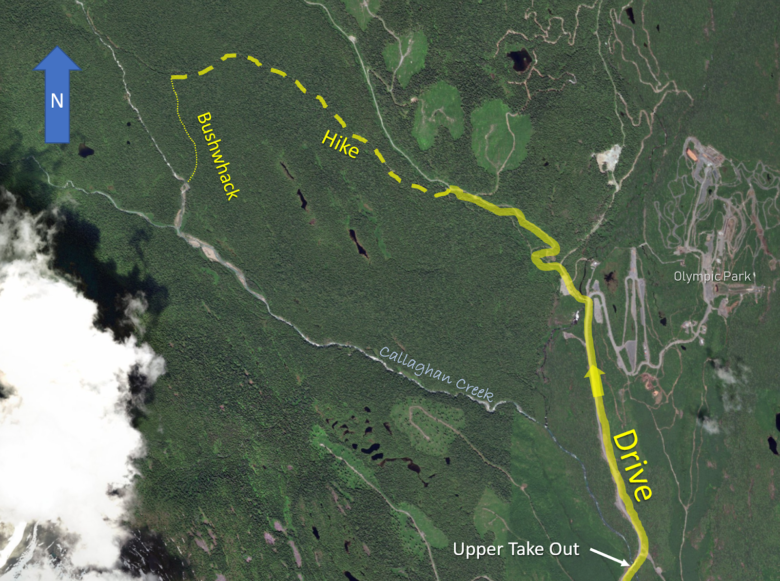
The day started with an easy 1.5 mile walk along a mostly flat snowmobile road.  As we approached the Callaghan Lake Fork the whitewater was audible through the trees.   We checked out this stretch of V+ whitewater, and decided to pass on this section. 


After some time spent considering where we would begin our bushwhack, we settled on entering the woods about 100 yards east of the Callaghan Lake Fork and held this proximity for the remainder of the hike.  The bushwhack was easy going with Emile leading the way, dragging our boats down the slight decline we took time to pear over the gorge walls when it was convenient.  Eventually the stream became easily accessible and we descended to creek level shortly below this point.  

Where we put in.


There were a couple hundred yards of boulder gardens and a log portage before we reached the confluence with an unnamed stream (originating near Powder Mountain) that marked the beginning of Callaghan Creek proper, discoloring the clear stream and creating the tan colored water those familiar with Callaghan Creek are accustomed to.  This is where we had intended to begin paddling and felt good about flows.  From this point there were no mandatory portages.

The first 15 minutes were easy boulder bar floating before the river showed its true character and entered a gorge reminiscent of the ones found on the lower stretch.  A couple of smaller rapids led to the first ledge, a five-ish footer with a twisting lead in.  We set some lax safety at the hole guarding the pool below and took turns paddling this rapid.  


Things picked up below here with a couple of boulder gardens and sliding rapids.  Shore scouting was always possible at the water level we were running the creek at (-0.05 new gauge/2.45 old gauge).

Ben and Emile cruising.


The signature rapid of the trip was a short ways into this gorge where the walls rose a little and the river dropped out of sight after some slides.  There is a scouting eddy a short ways above the entrance to this rapid, adjacent to a notable mid-stream boulder.


This rapid started off with a 6 foot ledge best run far left to avoid a hole and pocket on the right.   Just below is a 20+ foot falls, a slide to vertical on the left and a double drop on the right.  We spent some time scouting before deciding the right side looked better with the amount of water in the creek.  The hazards were the first part of the double drop had a hole/eddy combo that recycled behind the falls, then another hole/pocket combo below the second ledge that would only be a major hazard at higher flows.  We felt confident that we could hit the line and set about running this fun drop one at a time.  It is worth noting that a portage appeared possible through a gully on the left.


Emile drops the double.


Pretty excited about the run so far, we continued downstream.  Finding mostly class IV boulder rapids as the gorge continued on, we were a little stressed that we might get gorged in above an unrunnable/unportageable rapid.  Before long the walls got more vertical and an ominous drop presented itself as the stream entered a gorge.  We went for an extended scout on river right through the Devil’s Club and determined that while the next fifty yards was runnable, it was contained in a vertical walled gorge and the first drop was more dangerous than any of us were comfortable with.  Here, Callaghan Creek divided around a midstream boulder and dropped about 6 feet.  About 10% of the water went right over a runnable ledge.  The rest of the water went left into a siphon that was not conducive to human survival.  Just downstream was a boulder that would be a hazard at higher flows, we did not see anywhere to set meaningful safety.  Ben and I decided that running the drop was the correct course of action for us, but did not question Emile’s decision to make the exposed and semi-laborious portage on the right. 


We did not get any pictures of the siphon from upstream.  Here Emile Elliott looks back upstream at the crux move at the head of the gorge.


Both Ben and I made the easy, but necessary move to the right.  Emile had a couple sketchy moments on the portage.  The three of us felt a weight lift when we had all reached the eddy below this rapid.  Immediately downstream the gorge took a sharp right turn and we ducked a log that would require a portage at higher flows (I think you might be able to get out between the two drops if necessary and portage).  


The gorge walls recede immediately below the log duck, where a boulder rapid that we ran center to left was next.  Then as I recall the remainder of the run was class III-IV read and run with a short and splashy mini gorge thrown in to mix things up.  I took out on the left side of the bridge to do shuttle while Ben and Emile continued through the regular Callaghan run.

----------------------------------------

Access:  Most who would do this stretch would use it as an extension to the regular section, those paddlers can take out in the Cal-Cheak campground just south of the Hwy 99 (Sea to Sky Hwy) bridge over Callaghan Creek.  To only run the upper section, turn off Hwy 99 onto Callaghan Road toward the Olympic Park.  In 4.7 miles (7.6 km) a bridge over the Callaghan is crossed.  This is the take out if you are not continuing through the lower stretch.

* Between the upper take out and lower put in is a ledge, class II/III bouldery rapids and some gravel bar doldrums.*

Put In:  Continue up the Callaghan Road from the upper take out bridge towards Callaghan Lake, 1.4 miles (2.2 km) later (within the Olympic ski area), turn left onto the gravel road towards Callaghan Lake. 1 mile (1.6 km) past the Olympic Park a spur road will branch off to the right (stay on the main gravel road), a very short ways further the road makes a left bend, then a right.  Find a pull-out ASAP to park.  

 click on image to enlarge


Bushwhack downhill a hundred feet (30 meters) to a snowmobile road, turn right and hike 1.7 miles (2.7 km) to a point where you can hear the Callaghan Lake Fork.  Once you have confirmed where you are, enter the woods 100-200 yards/meters east of the Callaghan Lake Fork via a small rivulet.  Stay parallel to the Callaghan Lake Fork at this proximity for a little more than a half mile (1 km) to a point where it is easiest to drop into the Callaghan Lake Fork and paddle down to the confluence of the Callaghan Lake Fork and Powder Mountain Fork.  This confluence marks the beginning of Callaghan Creek Proper.  Be conscientious of wood above the confluence.


Click image to increase size.

Water Levels:  We had about 2.45 meters on the old Callaghan stick gauge (-0.05 on the new one) and 2.1-2.2 on the Cheakamus gauge.  This was enough water for our first trip with plenty of eddies, being from Oregon this felt like a friendly side of medium flow.  Knowing that up north they like their rivers full, this would probably be considered low to the locals.  A positive, those who paddled both sections of the Callaghan this day felt that the water was better channelized up high.  


Callaghan Gauge the day we ran the upper stretch.
It has been run lower.


                       -jacob

Thursday, October 31, 2013

Vertigo

Vertigo Gorge on Dipper Creek.


 The story of the first decent is one of the best trip reports I have ever read.  The chance to get in there to see the gorge and imagine what it was like for those who pioneered the run was an opportunity I didn't want to miss.

Heacam shots by Emile and Lucas. Dinsdale photos marked as such.
Scouting the entrance to Vertigo Gorge.

An ambitious crew of 8 turned into 4 when the reality of the trip set in the morning of.

We camped along the Ashlu and were hiking to the put in of Dipper by 10 on Saturday morning.

There are a couple warm up rapids and a couple warm up portages before the entrance drop.  We scouted the entrance for awhile before Willy dropped over with an inspiring line.


 He got out to set safety on the right.  Lucas went deep, resurfacing upright in the bowl on the left.  He was unable to paddle out, so Willy through him his rope, too short...  It had been cut the week before and unfortunately was not able to reach the cave.  Emile tossed Willy another one, who connected with Lucas this time and pulled him across the boil.

The view from the room on the left.


Emile's line was a similar story.  He and Lucas were enjoying the Vertigo pool when I hiked up to my boat and soon joined them in that spectacular spot.


                                                                        Dinsdale photo.


Willy continued to lead the charge over the crack drop into an incredible pool that turned out to be one of my favorite places on any river.

Head-cam of the crack.


Two fun boofs were below here and then a short optional portage. Emile exiting Vertigo Gorge proper.

Dinsdale photo.


 Not long after is the recommended portage. Here Willy describes the line.
The horizon line in the background is Rock Snot and scouting is an involved process.


Lucas, Emile and I roped our boats up a steep gully on the left with assistance from Willy.  Willy had seen the drop the week before and decided to forgo the scout on this trip.  When Lucas, Emile and I reach river level on the other side of the portage Willy came into view after a successful run over Rock Snot.

Rock Snot from the end of the portage.


It's not far below here to the BC Groove tube.  It has very dangerous wood in it and we were able to do a portage on the right that is a bit crumbly.

We ferried across the pool to the left to scout out the shipwreck falls.  I anticipated a painful landing as its not well aerated so decided to get it over with quickly.

 Boofing out next to the ships prow. 


 Willy parted the water in the landing zone on impact after his tail down boof. 


Lucas and Emile went for the nose down entry but took big hits as well.  

Dinsdale photo.


Emile on his way to joining us in the pool.


Taking it in

We then paddled onto the Squamish which is icing on the cake.  This canyon is gorgeous with splashy class IV whitewater.

We did the short hike out and Willy fired up the scooter shuttle sans breaks.  It was now 2PM so we rallied back to the Lyons Bay slide and do that.  Its pretty hard on gear but worth doing once.

It is advisable to try to do this slide at high tide.  There were rocks poking out in the landing zone when we were there. 


The video from our trip.


Dipper Creek from Difficult E on Vimeo.

We did the run on Oct 26.

Squamish Gauge                            

Elaho Gauge


The following video is from the week before we were there when Dan and Jeff did the first raft decent with Willy for safety.
Vertigo Gorge Dipper Creek B.C. from Daniel Mccain on Vimeo.


Vital information for this run can be found here along with links to the story of the first descent.

A quick tidbit about locating the hike out: A good spot to start the hike is the first boulder bar encountered on the left when the Squamish gorge opens up ever so slightly. 

 -jacob