Showing posts with label little north santiam. Show all posts

Thursday, November 12, 2015

Cedar Creek


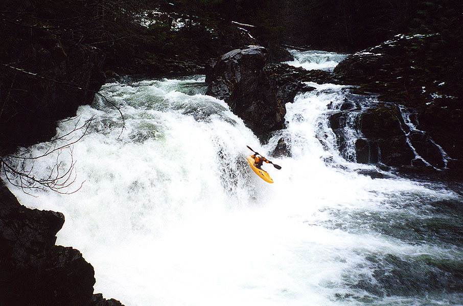
Photo: Priscilla Macy


BETA
2 miles, IV(V) with the option to put in higher for some V-V+


Stream: Cedar Creek used to have a notorious reputation as a fringe run, only for those looking to hairball down some class V+ with tiny eddies.  While you can pick off some large drops above the put in, there is also a roadside 2 mile section of nice class IV(V) that is verging on must-do for Willamette Valley boaters.

 Photo: Priscilla Macy


While Cedar Creek can be run on it's own, it combines well with a run on Classic Opal since it is easy to use the same take out at Three Pools.  From there it's just a short drive upstream to the bridge over the Little North Santiam at the Cedar Creek confluence.  Boaters can scope out the wood situation as they drive along Cedar Creek, there are usually a couple logs and some brush that need dodging.


 For how roadside it is, there are some beautiful spots on Cedar Creek.
 Photo: Priscilla Macy


Less than 1/4 mile upstream of the bridge is the campground ledge, where flows are checked.  Flow information is further on down this page.  1.7 miles after crossing the bridge at the LNF/Cedar confluence is the put in at a small pull out on the left.  If you make it to Sullivan Creek (a tributary with a big waterfall right next to the road), you have gone too far.  The put in is right at the base of Coombs (which you can glimpse from the road).   While most boaters will put in at the base of Coombs, boaters interested in V-V+ whitewater can check out the 1/4 mile upstream.  It's all roadside and the big drops are easy to scout.  If you are planning to run those drops, the whole section should be thoroughly vetted before tackling.  The eddy situation is sparse and the drops complex.

Hellevator, one of the big ones above the put in on Cedar Creek.


 Most people will skip the big stuff and put in at the base of Coombs.


Things start off with a short section of engaging whitewater.  After the first few rapids, things ease off for a bit and there is some mellow class II-III with a manageable amount of wood and brush to maneuver around.


One of the first fun rapids.

Things pick back up at Impaler, which comes just after passing a campground with a fence visible from the creek on river left.  Downstream the creek enters a straight away with a horizon falling back to the right at the end.  The eddy to scout/portage is on the left half way between the horizon and the sign in the photo below. 

Impaler is a two ledge rapid, the first is ugly and the second is good so most people choose to seal launch straight into the lip of the second ledge.  The second ledge can also be portaged with a seal launch a bit further down.  


A few more good class IV rapids separate Impaler from Box Drop, the second and final class V rapid.  Box Drop was also marked by a yellow sign in the trees on the left in 2020, just below a fun rapid with some offset hydraulics ending with what qualifies as a pool on Cedar Creek.  

Box Drop has been run both right and left, but also has an easy portage on the left. 
Ben does it right.


Some more read and run leads into the campground/gauge ledge, which is run center.


Then it's non-descript but steep whitewater all the way to the confluence, on both my runs we have hopped out once to scout down here.  Once on the Little North Santiam it's about 1 mile of boogie down to Thor's, which can be scouted along a trail on the right if flows are higher than you typically run Opal.

In 2020 there was plenty of wood and brush to be maneuvered around on Cedar Creek, but no wood portaging.  


Thorough scouting from the road beforehand makes the trip run smoother, as it's less likely stuff will sneak up on you.  While Impaler and Box Drop were signed in 2020, if you want to visually inspect the eddies before putting on you can do so 0.6 and 0.8 miles above the bridge at the LFN/Cedar confluence. 


Flows:  Use the Little North Santiam @ Mehama gauge to ballpark flows, keeping in mind it can make a big difference if flows are rising vs. falling.  We were there two days in a row to start off 2020 and the first day flows were higher than I would run the creek, with big holes and few eddies.  The second day flows were what I would call a perfect medium. Graph below.


Once at Cedar Creek, you can get a visual at the campground ledge, about 1/4 mile upstream of the Cedar/LNF Santiam confluence.


There are two rocks on the lip of the ledge that can be used to assess flows.  The one circled in blue needs to be covered for the creek to be worth paddling.  Perfect flows have just a tiny bit of water spilling up and over the rock circled in orange.  If there is enough water that you could potentially paddle over the orange rock, flows are high.  I personally would never paddle this creek high, as stopping would be a real challenge due to sparse eddies, it would be a high speed class V descent with wood in play.

Water over blue rock = enough water                                  Orange rock boofable = high water


High


 Perfect Medium.


Friendly and fun.


Access:  Take I5 to Salem and head East on Highway 22 towards Detroit Reservoir.  In about 22 miles turn left at a flashing yellow light onto N Fork Rd.  In about 15 miles the road turns to gravel, just under 2 miles after that turn right (there is a kiosk and some boulders at this location).  Just under a mile after turning right at the kiosks, pull right into the paved Three Pools Day use area (not signed).  Three Pools is the take out:  44.840457, -122.313914

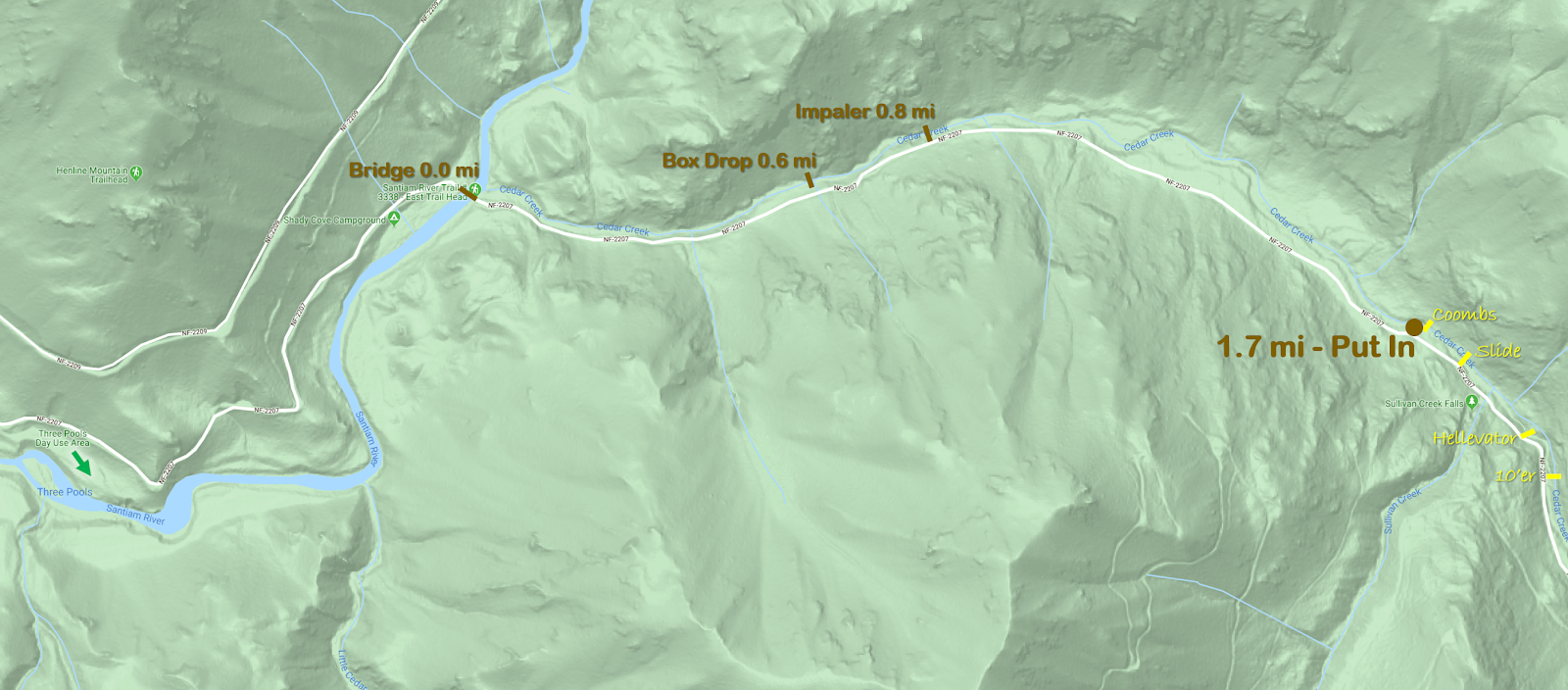
Coming out of the Three Pools parking lot, turn right.  In about 1 mile you cross a bridge at the confluence of the Little North Santiam and Cedar Creek.  In another 1.7 miles is the small pull out on the left adjacent to Coombs, this is the put in.  If you are looking at the creek from the road you should be able to catch a glimpse of Coombs through the trees.  If you get to Sullivan Creek, you have gone too far.

If you are interested in the 1/4 mile of V-V+ above the put in, it is all roadside and can be thoroughly scouted.  That section starts with steep bouldery rapids leading into a ten footer that need to be run boofing right to avoid a rock in the landing.  A hundred yards of more steep boulder garden leads to Hellavator, which is reminiscent of a more challenging Gorilla.  More steep boulder gardens lead to a fun slide just below the Sullivan Creek confluence, you can exit the creek just below this slide on the left.  Right around the corner from that slide is Coombs, without any real eddies above it.  

Click on map to increase resolution.


----------------------------------------------------------------------------------------------------------------------------------------------
The Upper 1/4 mile
----------------------------------------------------------------------------------------------------------------------------------------------


Cedar Creek has quite the reputation.  When the report from Oregonkayaking for the upper section was written, the creek was still being utilized as a hair-boating destination.  

Those guys went back and ran the lowest mile a couple years later, which seemed like it would appeal to more boaters, but was pretty short.   

After a couple scouts and confirmation from Pete Giordano that it really wasn't all that bad I was set on trying it out at some point.

Last weekend we were floating by on Classic Opal and noted that Cedar looked like it was at a good flow.  Once we reached Thor's, it was decided that instead of doing the usual and continuing through Opal Gorge that we would pack up and check out Cedar.


We noticed a log portage a hundred yards above the confluence with a convenient trail up to the road just above so used that as our take out.  Continuing upstream we scouted the eddy situation for Box Drop, The Impaler, Coombs, and Hellevator at about .6, 0.8, 1.7 and 1.9 miles above the bridge near the take out respectively.  Fortunately all of those spots are visible from the road for those with a sharp eye.  


Ben Mckenzie and Brian Ward put in where Oregonkayaking put in, Brian Butcher and I put in at the confluence with Sullivan Creek.


Ben Mckenzie and Brian Ward warm up above Hellevator.


Neither of them were able to hit a boof on the first ten footer, but both were online and avoided hitting the rock that is deep in the center of the landing. They paddled some of the boulder garden downstream before climbing up to the road to get around Hellevator. Hellevator is like a stouter version of Gorilla on the Green River in North Carolina. The walk was easy along the road on the left, and we all put back in just above or below the Sullivan creek confluence.

Looking into Hellevator along the portage on the road.


 Just downstream of Sullivan was a fun slide, the best drop on the whole creek. I sent everyone down on verbal before joining in on the fun myself.

The Slide

Almost immediately downstream was Coombs, Brian Butcher portaged left just below the slide which was the thing to do. The rest of us portaged the ledge on the right, then ferried across to where Priscilla (who was providing ground support along with Sam Box) pulled us onto shore. This is the trickiest eddy situation on the creek, and really we all should have done what Brian Butcher did. Ben looked at Coombs seriously, but in the end decided to join the rest of us in the portage on the left. I feel Coombs looks better at higher flows, but is always on the V+ side of things. Very runnable, but stout.


Below Coombs we entered the normal run, and it was a good time making our way downstream. The run was consistently steep class IV, a few times we had one person hop out and send the rest through on beta. 


Priscilla and Sam helped us spot the eddies above Impaler and Box Drop, which was a big help as they sneak up. (2020 they are now signed).


The first tier of Impaler


Brian Ward finishes up Box Drop.

We skirted one log on the left and took out on the left just above a sign reading "One Lane Bridge".  

A good run, one I will certainly be back to.


We had flows peak at 1,200 cfs on the Little North Santiam @ Mehama gauge on (Nov 8, 2015) and thought we had a good level.


Gauge ledge


Just upstream of the confluence with the Little North Santiam the day we ran it.


-jacob

Friday, March 27, 2015

Elkhorn

No Coffee down there, T minus 1600 feet.

All photos: Emile Elliot   

Elkhorn is too woody upstream of Big Twelve Creek to be worth running in my opinion.  From there down a few large rapids with wood still need to be negotiated before reaching the final canyon which has some nice boating and is described on Oregonkayaking.  Crunch N' Munch requires some creative portaging when flows are up, Razorback is just downstream and should be run center/right, erring to the right.  Getting to the creek is the largest obstacle to overcome.  We have it on the list this summer to try and figure out access via Big Twelve Creek, it looked to have some clean drops on it.  When we ran Elkhorn, we put in near the end of the road on the north side of the drainage (NF-201) and ran out of light shortly after exiting the final canyon section.


The access road is at about 4,000 feet and often snowed in, the following pictures are from tripcheck and these locations can be used to assess whether the road to Elkhorn will be drive-able.  We had no issues with snow on the road when we did the run.

Day after we ran Elkhorn, similar to the day of.


 The snow conditions where we put on Jan 19, 2015 around 3800 feet, near the end of NF-201 at the junction with a spur road.   44.8153, -122.2886

                                 
The hike in was steep and brushy, but doable.  Dropping 1200 vertical feet, there was only need for a rope at one cliff band.  Lucas part way down the hill.

There were a couple of stand out rapids above Big Twelve Creek, but too much portaging to see a return trip from anyone in our group.  It's unfortunate the wood is there because the creek bed is high quality.

 Ben, motivated as always picked off one of the rapids the rest of us chose to walk.

Eventually we passed by Big Twelve Creek and the stream got a little larger, if we return it will be via this creek.  At some point below this confluence we came to a rapid we had been on the lookout for, since we had heard Willy Dinsdale's story of having one of his top 3 worst swims in this rapid.  We dubbed this rapid "Wet Willy", in light of that sans boat trip Willy took through this rapid when running the stream at higher flows with his brother Ben.  Helmet Cam footage of that event can be seen at the end of the following video.


At the lower flows we had, the rapid was more manageable.  Though most of the group still portaged. 

The top ledge of Wet Willy.


Only Ben ran the sieve drop at the end of Wet Willy (11:20 in the video).

 Below here be ready to get a little creative until you are below the "Potato Rapid".  There are a few good rapids in this section, also many difficult rapids with large boulders and wood hazards.  In this section Ben caught the scariest eddy I have seen caught in person, mere feet above where his channel went underground.  

It wasn't all a wood fest, there were clean sections of Elkhorn below Wet Willy.  


One of our favorites was a unique triple drop called Blind Luck. signaling the start of the Oregonkayaking section.  Its hard to see around the corner after the first two drops, but it was clean when we were there.  Scouting from the left is harder, but would offer a view of the third tier.

Emile enters Blind Luck


 All of the portages on the run were low difficulty aside from Crunch N' Munch, though they add up after awhile.  Below the Potato Rapid (read Oregonkayaking report) its read and run to the take out with a couple of wood hazards.  As I mentioned earlier we ran out of light just below Potato Rock and ran a half mile of class IV in the dark before stashing the boats and walking to the road.  Ben finished the run in the dark and the recovery team who came in the next weekend to retrieve the rest of the boats (Joe Kemper, Anna Herring, and Emile Elliot) was surprised he hadn't gotten stuck in one of the two log hazards below where the rest of us walked off.

The boats were patiently waiting right were we left them when the recovery team went in the next weekend to retrieve them.  We have learned that when hiking out, it's best to ditch the boats near the creek.  In the past we have tried to hike them out, only to ditch them in the dark part way through the hike and struggle to locate where we left them.  It's much easier to find them if you leave them near the creek where landmarks are easier to come by.


We had 2,000 cfs which we felt was the minimal flow to be considered "in", though it has been run as low as 1,100 cfs.  The Dinsdales had 4-5000 cfs and called that medium high.  Does this mean 3000-4000 in the LNF@Mehama is medium?  Maybe.  If I go back I would shoot for 3000.

The section I would consider returning to.

  If you enjoy this type of trip, try to figure out access via Big Twelve Creek.  If you do not enjoy adventure, you will not enjoy this creek.


If you do the run, be ready for the unexpected, Elkhorn is full of surprises both good and bad

 We even saw a unicorn!

At the end of the day Elkhorn is a tough day of boating, and a magical place.

Now most of the pictures were of the good stuff, so before deciding an Elkhorn trip is for you take a look at the following video Anna created highlighting the tedious portions of the trip.
     

       -jacob

Thursday, November 6, 2014

Opal Proper

Photo: Pete Giordano


BETA

Stream: The put in is a little over 1 mile upstream of Jawbone Flats.  The standout rapids on this run are all bedrock.  Most of them are runnable, while some of them are not, while nearly all are unique.  There are some short waterfalls, slides, ramps, chutes and pockets.  Scout each rapid carefully, fortunately it is usually obvious straight away whether you are looking at a fun rapid or a portage.

Part of the fun of this run is figuring it out like a puzzle.  There are a few portages (all easiest on the left) mixed in with fun and unique bedrock rapids that are sure to leave you smiling.  Scout everything your first time down, and don't go around any corners without knowing where your next eddy is.

The competency crux of the run is the final portage.  There is a ten foot falls that splits around an island with most of the current going left and a semi-scenic tributary coming in on river right.

                                                       The aforementioned Flume Creek Falls

If you have made it this far, I am sure you will recognize this as an unsafe drop as the landing zone appears to be exploding.  Head up to the trail on river left and instead of returning to the creek as early as possible, continue walking down to a foot bridge (don't drop back to the creek earlier that that bridge).  Put back in wherever you feel comfortable finding your way down below this bridge.

Shortly below here you will reach the confluence with Battle Axe and your trip down Opal Proper will be over.

If you did not get an early start, hiked slow, had carnage or fiddled around you will be noticing that the light is starting to fade.  If that is the case, start looking for the road on river right to hike out on.  You can continue all the way to Cascadios De Los Ninos before being committed to running the entirety of the Upper Opal section of the Little North Santiam.  

If you were efficient with your time, you can look forward to more boating.  The most obvious choice is to continue down through Upper Opal to the Mine at the Classic Opal put in, where a short uphill hike along the road will return you to the gate where you began your hike that morning.   Though if you were moving really quickly you may have time to go further if you set shuttle beforehand. 


Flows:  1,000 cfs is bare bones on the Little North Santiam @ Mehama gauge, 1500 cfs is the level shown in the video below and was a friendly, enjoyable level.  No idea what the upper limit would be, I wouldn't hesitate to head up there with 3,000 cfs and dropping though.

Access:  Take I5 to Salem and head East on Hwy 22.  In about 22 miles turn left at a flashing yellow light onto N Fork Rd.  In about 15 miles the road turns to gravel, and at 21 miles you will reach a gate where you leave the vehicles, a location that has a $5 fee to park.  


**If you know you are an efficient boater and think you will have time to do both Upper and Classic Opal after Opal Proper you can leave a vehicle at Three Pools to rid yourself of any hiking at the end of the day**

From the gate, get your gear carrying devices out and head past the locked gate up the gravel road about 3 miles to Jawbone Flat along a nice gravel road.  This is a perfect use of the kayak wheels. After reaching Jawbone, head to the back of town and over Battle Axe Creek.  Veer right just after the Pelton Shed, passing through an open area with a gravel pit.  Just passed this open area will be a sign for "Opal Pool", if you like drop your boats here for a moment and hike down to scout the nasty rapid that lands in Opal Pool.  It is worth checking out the situation above this drop so you don't accidentally get blown into it.


Return to your boats and continue along the path, shortly the path will make a sharp bend to the left and a small trail will head off to the right; take this trail to the right.  Follow the trail for a little over 1 mile, at about this point you will see nothing but bouldery class II above you and it is time to put in.  

               Looking upstream, then downstream from the put in.  On the downstream end of Cedar Flats.


 Map of the area
click to enlarge


----------------------------------------------------------------------------------------------------------------------------------------------
Original Write-up
----------------------------------------------------------------------------------------------------------------------------------------------


I realized a funny thing a couple years ago.  This being that I had many times planned, joined and executed kayak trips to "Opal Creek" in the North Santiam drainage without having ever run Opal Creek itself.  This was not due to debacles, in fact, those trips were all fun and usually smooth.  This is because I had never intended to put on to the actual Opal Creek in the first place.  From the confluence of Battle Axe Creek and Opal Creek near Jawbone, the stream the boating community usually refer to as Opal Creek is actually called the Little North Santiam.  I had read the Oregonkayaking trip report and decided I would one day try to head up and boat the actual Opal Creek.

---------------------------------------------------------------------------------

I went up to check out Opal Creek proper (above Jawbone Flat) fall 2014 armed with beta collected from the report on Oregonkayaking.  I was hoping that making my trip early in the year before the snow hit would give me a more positive outlook on the stream.

Video from the trip.

There have been a few changes since the OK trip occurred, here are the changes I noted


  • There is a new trail up creek right (OK travelled on creek left) that was not difficult.  I would not be excited about trying it in the snow though. To find this trail, locate the signs in Jawbone Flats to Opal Pool.  Once you scout the Narrows, return to the old road/Kopetski trail and follow until a sign for the Kopetski trail takes off to the right.  Follow this to wherever you decide to put in. 


  • The log bridge mentioned in the OK TR is gone now


  • The logs at the lip of Log Leap Falls are gone.  It is still a dubious drop that I did not run, but with safety and the right group it may go.


  • Because I had read the OK TR I knew what to expect on the run, this allowed me to not have to hike out from Cascadios Los Ninos at the end of the day.  Even with a late start I had plenty of time to paddle down to the Mine.  If I were to repeat this run and had a shuttle, I would try to get an early start with the idea to take out at Salmon Falls for a nice long day of boating.

--------------------------------------------------------------------------

Other notes


  • I had 1500 cfs, same as oregonkayaking, but without the snow I ended up having a little more water.   This was a good level and I would think 1500 would be the ideal level to do Opal through Salmon Falls.


  • The Narrows into Opal Pool addressed in the OK TR is just as menacing as they claim, it appears that it would be very easy to boat scout past the last eddy here.  If you portage Log Leap on the river left trail, keep walking until past this section.  If you run Log Leap, take out as soon as you can egress up the left bank through the brush.  Or better yet, make a plan as you hike upstream at the beginning of the day.


  • The rapid described as just below the log bridge is just as fun as noted!  Great rapid.  Quote from Jason “This is one of the most entertaining drops I have run in a long time; if we hadn't been so concerned with time I would have hiked up to run it again and again!“


  • There were a handful of portages, I did all of these on the left.  If you are creative, none of them are strenuous (without snow).


  • I used a wheel system to get my boat to Jawbone, this helped a lot.


  • It took me 5 hours car to car.


  • The scenery is classic upper LNF drainage and there are enough unique, fun rapids to make this trip worth doing.  I won't be hiking all the way up there every time I am in the area, but I wouldn't say no to a return trip in the future, near or far.


  • I agree with OK that Battle Axe has more runnable whitewater, but the best/most unique rapids are on Opal.  If I were to have a rule of thumb about the area above Jawbone, I would say one Opal trip to two Battle Axe trips sounds about right.


If you are the kind of person who enjoys this type of run, that should be more than enough info.  Go when there is no snow and enjoy!  


               -jacob