Thursday, June 4, 2015

Upper Sultan (Dam Release)

  Written by Priscilla Macy


Finding a singular trip report that provides directive and up to date information about the Upper Sultan is as about as elusive as the run itself.  Oregon Kayaking has a write-up from their trip in 2005 and American Whitewater provides a brief summary of the run and the river including information regarding the logistics of flows and access.  After completing a trip down the 13 mile stretch in April 2015 I felt compelled to provide a more recent trip summary.

The Sultan River is under management of the Snohomish PUD.  Water is released from Culmback Dam as a condition of the hydropower license for the project requiring process flows. These periodic high flows were designed to benefit the overall health of the river. Thanks to efforts from American Whitewater, and more specifically Thomas O’Keefe, the event for the first time was scheduled on a weekend with advance notice to allow whitewater paddlers to take advantage of the opportunity. 
Snohomish PUD requested that paddlers sign up in advance of the release, with a minimum of six paddlers needing to commit.  I was told by PUD officials that by the day the release, over 150 paddlers had signed up for the event.  Snohomish PUD did a great job of managing the crowds and even provided aerial footage of the run for boaters to use as a scouting tool prior to the release.

The trip starts out by parking a vehicle on the Culmback Dam Road to the Gateway trail-head. From there, you hike for a mile of gravel forest road to the trail-head for the new Sultan River Canyon Trail. From the trail-head, it’s another mile to the river and put-in at river mile (RM) 15.5.


Registering with PUD and gearing up before the short hike-in. (Photo: Matt King)

  
There are few flat sections on the run and aside from wood portages (that are subject to change each release), every drop is runnable, and requires a solid class IV skill-set.  The majority of the run can be boat scouted and setting safety or getting a better look at the larger drops from the banks is relatively easy. 

The first section begins after passing beneath an old bridge and consists of a few miles of fun boulder gardens.  As for most of this run, wood hazards in even the smaller rapids deserved attention.


One of the first boulder gardens after the bridge. 

 More fun read-and run


 More fun boulder garden drops

The first portage,  a river wide log-pile cause by a small landslide, is easy to spot. Portage river left.

First wood portage


 There was no shortage of fun read and run in the upper section.  

Run a couple more rapids before coming to a slow moving pool, marking the second wood portage. Portaging is easier on the right, but portaging on the left allows boaters to run the last part of this rapid.

 Second portage.


This rapid could be run, but all in our group chose to walk due to some badly placed wood in the middle of the rapid and a large retentive hole at the bottom.

 My line at the bottom part of the rapid.  Photo: Matt King


After portaging, the best way back in was putting in river left and seal launching off a rock into the last part of the rapid, avoiding the hole by going left.  After this portage, we found numerous rapids.  Be prepared to boat scout, or get out to assess for wood hazards.

 A fun log-duck move below the second portage.


Scout this one river left to spot your line.

More boulder gardens follow the second portage.  Scout the next one on river left.  We ran this one entering to the right of a boulder at the top, and driving back left through the two boulders at the bottom.  There was a nice boof line between the two boulders (pictured at the bottom of the rapid, left side of the above photo).  There is a short pool in between this drop followed by the next rapid.


  Matt playing in the hole between the two boulders (same rapid).

 The next rapid is easily scouted from above on river right. 


The next drop was one of my favorites because of the unique airplane turn, challenging to thread the needle between the seams. There were some creative lines by our group in this drop, Nick was the only one to clean it.  The rapid is followed by another nice pool for recovery, and scouting and setting safety is easy to do from river right.


About halfway through the run (6.5 miles from the dam) you reach a diversion dam. The structure must be portaged on the trail on river right (this is a City of Everett PUD rule and violating could compromise future kayaking opportunities). It is possible to put in at this diversion dam by hiking down a gated road on river right if you wish to only run the lower section of whitewater.  If this road is gated, the hike is 3.1 miles. Downstream from this point the river picks up in intensity with class IV-IV+ rapids that provide small pools in between for recovery. These are the best drops on the run and you'll likely notice an increase in flow coming in from larger side creeks.
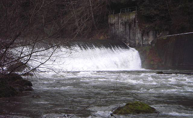
 
 Photo of the dam: Oregon Kayaking Trip Report, 2005

After the diversion dam, you run a few smaller read and run rapids bore reaching the first rapid of distinction.  This rapid was a bit tricky; you can see the branch sticking out of river left (pictured below).  It was relatively easy to avoid, and like most drops on the run, easy to scout and set safety from below.


 First rapid of distinction after diversion dam.

 Matt sets safety from below. Here you can see both the sneak line (between the two boulders on the left) and the main line in the middle on the same drop.  Both lines work just fine.


From above, the next rapid looked like another read and run.  We all routed through the drop, to find a piece of wood that was in the middle of the rapid.  Two paddlers in our group “rail slid” over the wood, others were able to avoid it.  Enter with caution, as there is pin potential with the current placement of wood.  

  Lila punches the final hole in the above described rapid.  The wood cannot be seen from this photo beacuse it is slightly covered by water.  It is located a short distance above where Lila is pictured, in the middle of the channel.


After this point, there is a little bit of boogie until you reach a big pool, which marks the infamous “Landslide” rapid.  A group of paddlers in 2004 were separated by the initial landslide, leaving the group downstream, with little water from the dam created by the landslide, and the group upstream with the option to try to cross the slide, or to hike out. They hiked out. 

In 2005, a group from Oregon Kayaking went in and the drop was still not runnable. The rapid has since been anthropogenically altered for fish passage.  The resulting rapid is more manageable, and it saw numerous descents during the 2015 release.
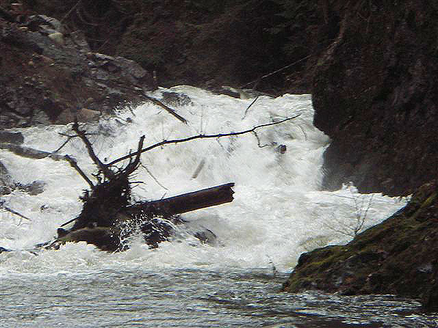


Oregon Kayaking’s photo from a later trip in 2006.


Landslide Rapid, 2015.  Ben McKenzie taking home all the points for style, and being the first in the group to probe the rapid. Photo: Nick Hymel

My line.  Photo: Nick Hymel


While most of us went deep in the seam on the left, Jacob chose a route down the middle that avoided submersion.
 Photo: Nick Hymel


Matt King charging the seam. Photo: Nick Hymel


Jesse Shapiro about to test the depths. You can see the pocket on river left in this photo that many of us flushed into, fortunately it was pretty friendly and everyone was able to hold on and roll up.  Photo: Nick Hymel


It should be noted that due to the dynamic nature of this river, and the slide area itself, this drop could change every year.  We all felt the drop deserved class 5 attention, but was more forgiving than many rapids with that distinction and was definitely one of the most fun drops on the run.  There is also an easy portage option across the slide on river right.

After this, there are a few more read and run rapids before you approach the powerhouse.  Pick out a line over the low-head diversion dam, and continue on to Last Nasty- the last formidable rapid on the run.  This one is aptly named, as it is easy to float into it and assume it is another  read and run.  The rapid deserves attention as the wrong line could place you in a sieve or get you pinned.  Our group floated into this one resulting in one pin, a few surfs and a lucky line that barely missed the main sieve hazard on the left.  The entrance to the rapid is marked by a large boulder in the middle of the river.  Take the right channel and find an eddy to scout.


You want to catch the eddy on river right to scout the last part of the drop.  You can see the sieve pictured river left, we chose to run the final ledge 5-10 feet off the right bank though many lines were taken during the release.
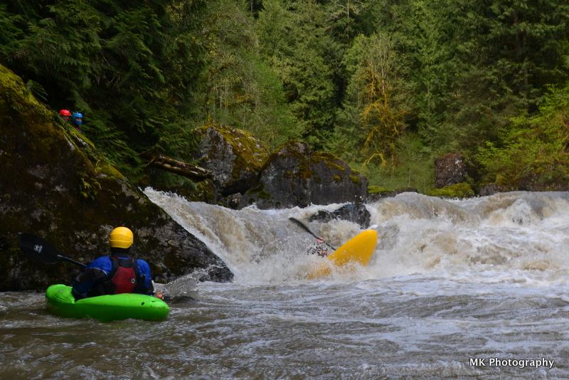


Last Nasty from below, Ross clearing the hole.  Photo: Matt King

From this point there is very little until you reach the Trout Farm takeout. Overall I thought this was one of the more unique and enjoyable runs of the year. We had around 900 CFS, and felt that was a healthy medium flow. Overall I thought this run lived up to my expectations and offered fun, clean rapids, unique scenery and a great opportunity to get on a run that is not often accessible.


Access (From American Whitewater):


PUT IN:

Just east of the town of Sultan (Highway 2 mile 23.1) turn north up Sultan Basin Road towards the Sultan Basin Recreation Area. Follow this road 13.5 miles to Olney Pass. The Culmback Dam Road heads down to the left. This road was gated for the past few years but more recently it has been open and the road is a public easement to Forest Service property (in the past Barry Chrisman, the Hydroelectric Plant Supervisor has answered questions regarding gate access and he can be reached at 425-783-8804). Just before you reach the dam an old forest road turns off to the left (FR 6122, aka the Jenny Ring Road). Drive up this road to a large clearing and start walking. The traditional put-in was reached by following this road to the old log bridge a couple miles downstream from the dam (47.9701N, 121.7228W, WGS84). As a condition of the new hydropower license American Whitewater negotiated the development of a new trail into the canyon that was professionally constructed to Forest Service trail standards and completed in 2014. This trail puts you in the river one mile below Culmback Dam. Scrambling down the face of the earthen dam is tempting but illegal and you likely want to get a bit downstream of the dam to find enough inflow from the sides. Snohomish PUD has installed security cameras here and informed us that they will not tolerate trespassing on the dam. The other difficulty with putting in at the base of the dam is there are reports of some class V rapids in this section that may be difficult to scout or portage. Steep canyon walls limit access between the dam and the old bridge site although there are a couple spots where river access is possible.


TAKEOUT:

Most continue on the Sultan below Powerhouse run and use the Sultan fishing access at Trout Farm Road. You can reach it by taking the first street east of the Highway 2 bridge across the Sultan. After turning onto this street in the town of Sultan, take a left headed back towards the river. When you get to First Street follow it north as it parallels the river. As you pass out of town, slightly less than a mile down First Street, Trout Farm Road turns off to the left. Follow this 1.3 miles to a well marked fishing access point on the Sultan River. Park in the gravel parking area near the road and walk down a dirt road to the river. Alternative access points are available at the Powerhouse but gates will likely be locked by the time you get there, requiring you to continue downstream (they may be open on scheduled release days however).


Monday, May 18, 2015

Sierra Blitz

What's left to say about kayaking in the Sierra Nevada Mountains that hasn't already been said? The area is home to arguably the best kayaking in the world and is a mere state line away from Oregon. That being said, I don't make it south nearly as much as I'd like, a fact that has been compounded in recent years by the worsening drought along the west coast. This year I was determined to get some boating done in CA, drought be damned and when the little snow they had started to melt, we were ready.

Scotty Baker, Matt and myself left Bend around 1 in the morning and drove through the night in an attempt to maximize the small window of free time we had with as much boating as possible. Taking shifts behind the wheel, we made it to Placerville by breakfast and were gearing up at the South Silver put-in by noon.

South Silver lived up to the hype. One mile of granite slides that drops over 600 feet in elevation from start to finish. The highlight was running the SKyscraper/Off-ramp combo near the end of the run. We were joined by Anna Wagner and Matt Parker of Coloma for the descent and had a blast lapping numerous drops and playing around in that Cali sunshine. Spirits were high moving on from South Silver, despite the unfortunate fact that our beer bag had been stolen from the take out! Damn fisherman.

That evening we rallied a few hours south and met Matt's brother Sam and his friend Grace at the Iron Door in Groveland. After closing down the bar, we crashed out in the parking lot and awoke early to catch the release on the Cherry Creek section of the Tuolemne River. sam and Grace were kind enough to drive our shuttle and we picked our way down this Cali Classic. After sharing a few beverages and catching up some z's at the take out, we rallied back up the hill to Groveland to grab some food and check flows.

This is where things started to go a little side ways. After making a few phone calls, we began to hear that folks were holding off on Upper Cherry (our main goal of this trip) for levels to drop a bit more. Having a distinct time crunch and will the old Hetch Hetchy gauge reading a perfect level, we decided to go ahead with our original plan at pull the trigger on Upper Cherry. After grabbing a few more supplies, we headed up towards Cherry Lake and began to pack.

With 80 degree temps predicted, we opted to knock out a few miles of the hike into the put-in (10 miles total) at night, in an attempt to beat the heat and breakup the slog a bit. The night hike was absolutely amazing. Not only were we graced with full moon to light our way as it reflected off the white granite all around, the darkness made for some amazing views out into the valley to the west. After knocking off the first 3 miles of the hike (the steepest bit) we eventually lost the trail for a minute and decided to crash out and use the dawn to rediscover our route. Sam and Grace had decided to tag along and meet us at Flintstone camp on our last night on the river: besides the great company, they also provided a good supply of Sierra Nevada Pale Ale. Thanks guys.

The next morning we awoke to an amazing view. After a quick breakfast, we hit the trail and did the best we could keep moving towards the put-in. Hiking with a boat sucks. There's no two ways about it. I like to employ the sprint and rest method when dealing long hikes in. Set a goal (ie. the next ridge line) get there as fast as you can, and reward youself with an extended rest. No matter how you cut it, hiking with a loaded boat at elevation for 10 miles is a bear. That being said, Dan Rubado excels at this skill and caught us on the trail before too long. (he started hiking at 9 am and caught us around 1pm) What a beast.

After finally reaching the put-in we took a moment to enjoy the crystal clear water and slowly got around to loading up our boats. After everyone was set, we paddled across the creek to scout our first rapid of the trip (the "Put-in Slide.") This is when we first realized just how sideways things had gone... The normally manageable looking class V slide was absolutely ripping. We had very high water! After a quick discussion, we opted to walk the slide and began moving down stream. We decided that even with high flows, it would be easier to progress down stream, portaging where we needed to, then to hike our boats back out over Styx Pass.

The one benefit of the high water was that it made all the inbetween rapids on Upper Cherry super padded out and really fun. What's normally shallow class III slides became roaring class IV and V rapids that all required scouting. We had a blast working our way down stream and picking apart the upper reaches of Cherry.

After a rather long day or routing and walking, we arrived at the lead-in to Cherry Bomb gorge. We all knew that it was going to be far too high to run and began to long portage up and over the granite dome. We were greeted by Sam and Grace at the bottom who had cold beer and fire waiting for us a flint stone camp. A few hours later, we spotted another group working their way through the portage and soon were joined by a few friends from the gorge along with some Cali locals. Good times around the fire in a beautiful setting.

The final day on Upper Cherry starts off with a bang. Names like "Perfect 20" and "Dead Bear Falls" are world famous and their all packed into a single mile of granite goodness. Unfortunetly, the water was coming up, not dropping and we started our day with an extended portage around waterfall alley. Once back on the creek, we again began picking our way down the creek and enjoying beautiful scenery and really fun rapids. Before too long, we hit the confluence with West Cherry Creek and entered the Red Rock gorge. Another gorge that is typically considered tame and more modest flows, the Red Rock was padded out and we ran some great rapids with one portage mixed in the middle. Moving as one big group now, we got to see some of the boys fire up a few drops that we passed on.

The last gorge on Upper Cherry is often overlooked when reading through the many descriptions out there on the web, but it can't be understated when actually descending the creek. After a long scout, we all opted to walk the gorge in its entirety by following a decent trail high on river right. The gorge goes, but it's full on in there and many of the ledge holes look terminal with limited safety options.

The last leg of an upper cherry trip is the 4 mile paddle out across cherry lake (one reason its hard to get a visual on the flow before walking in). We learned later that their is an old dirt road you can follow on river left (lake left) that cuts the paddle out down significantly.After grunting out the final leg, we were greeted once more by Grace and Sam and toasted to our adventure. It wasn't the classic Cherry experience we had all dreamed of, but we still conquered an amazing section of river and got to spend 3 days in one of the most unique settings I've ever visited. It wasn't always easy going, but we worked as a team to get through it, and had a whole bunch of fun along the way.

Cheers, boys. Lets do it again soon.

Now just for the 10 hour jaunt back to Bend... I made it to work Monday morning..

Here's the video.
Enjoy

Beating the Drought: South Silver and Upper Cherry 2015 from Nate Merrill on Vimeo.

Thursday, May 14, 2015

One Hit (a year) Wonder

Our friend Alex comes into town every once in awhile and we are usually able to get him back in an IK once a year or so.  The last couple times it has been in the summer and he has gotten low water runs in on the Truss and Little White Salmon.  This year he was here during the weekend of the Creeking Competition and we were able to get him out on Canyon Creek, WA for a lap.  We didn't race this time so loaded up on the media and Nick was able to produce a quick edit of the trip.  Alex had a no portage/no swim day, not bad for a once a year boater!

Tuesday, April 28, 2015

A Personal First


The personal first descent is one of the most fulfilling experiences one can have on a river; no matter how popular or regularly run something may be, achieving a goal and running something new always feels like a great accomplishment. Leading someone down a river for their personal first is similarly awesome and gratifying.  Looking at the river for all its lines and intricacies, finding the best places to set safety, being super diligent about having good communication, maintain a good group dynamic (smiling!),  and assembling a solid crew ensures a great day on the river and makes for a successful personal first.

Last weekend, Anna Herring made her first descent on the magnificent Little White Salmon.  A river that many of us know so well, and still we find so much pleasure passing through that canyon time and time again.  Nate, Lucas Glick, and I accompanied her, with Lucas and I setting safety at a few of the more consequential spots (Boulder Sluice, Sacrilege, S-turn, Horseshoe), and Nate leading her through everything.  It worked great, and Anna absolutely killed it.  It's a mark of a good boater when they step up to something new and are more than ready for it, those are the boaters I want in my crew!

One awesome thing about going in there with Anna and setting safety, I was able to bring my camera, getting out at spots in the river I never have before and getting to know the Little White a little bit more intimately.  Also, it was great to work with Nate and Lucas and line out the best rescue options for each of the big drop.  Setting safety made for some sweet photo angles too, as you can see below.   Most of all, it was wonderful to see Anna kill it and another fantastic day on the Little White.

Nate Sluicin into the light

Anna's  Sluice run after styling Gettin' Busy!

Nate digging into Sac
Anna Styling again
And she styled S-Turn


Airborn at Wishbone
Glick Gutting


Still Stylin at the mental crux; Horseshoe
Glick was fired up, I almost missed him boofing hard

Chaos Wheelie


The perfect crew (Oakland not withstanding)!


Thursday, April 16, 2015

100 rivers: part 2

For awhile now, my father has been working towards the goal of having run 100 rivers.  For awhile he was sitting in the high 90s, only a couple away from his goal.  With his birthday coming up this last February we hatched plans to accomplish his goal the day he turned 52.  The weather cooperated and the Quartzville drainage had plenty of water.

Power was out in the Lebanon area due to a dozen or so power lines that had fallen onto HWY 20 with the high winds, slowing things down a little but before long we were cruising up the always longer than I think its going to be Quartzville road.

We started the day on Upper Quartzville for some fun assurance before hitting his 100th stream in the form of Canal Creek, a tributary to Quartzville.

Quartzville went well and we had a blast, even with two new pieces of wood blocking the classic lines in David from Behind and the log duck.  We used an alternate put in that added a neat culvert rapid and dropped us into Quartzville just before Technical Difficulties.  Quartzville really is a great run with easy access and many class IV rapids.

We set our second shuttle at the confluence of Canal and Quartzville and headed up to the Canal fork of Canal Creek.  I had heard from the generation of Corvallis Creekers (Eric Fostermoore, Rick Cooley, Josh Grabel, Chris Gabrielli, etc) before the current version that the Canal fork had some stuff on it including a class V rapid.  We hiked/roped our boats in and made good time down the stream, there were logs here and there but nothing to complain about.  Before long we reached the Class V drop, which looked tough and consequential and we decided to portage on the right.  Below here were a few more fun rapids before reaching the confluence with Elk Creek and the stream became Canal Creek proper.   We had plenty of time so continued down this fun stretch of stream that had lots of class III slides, one larger blind slide (center left was good) and 2 stand out boulder gardens near the end.

The day was ultra smooth and rewarding, the power was even back on by the time we returned to Sweet Home, allowing us a food stop on the way back to town.  Here is a video of the trip.


Quartzville Creek gauge went from 1200-6000 cfs throughout the day.

   -jacob

Wednesday, April 8, 2015

Drift Creek (Siletz Drainage)

Photos: Priscilla Macy

I expected this run to have only a handful of mediocre rapids separated by miles of flat water.  Lucas, Priscilla and I all wanted to see it anyway so went there on a sunny Monday after the 2015 Wind River Race.

Put-In for the guidebook run near North Creek.


 We found the run to be more enjoyable than expected at around 1,000 cfs with entertaining intermediate rapids in a nice gorge.  The run is described well at americanwhitewater.org complete with plenty of pictures.  The first gorge is the best, with bedrock rapids back to back, good scenery, and unique lines available.

First Gorge


The middle of the run doesn't have much going on, but it keeps moving.  Near the end of the run the whitewater picks back up and there are a few more fun rapids.

A nice boulder garden leads into this ledge that is larger than it may seem in the picture.

 Lucas scopes out a line.


 Once you see the pumping station on the left the run is over.  The two mile paddle out at the end isn't the greatest, but it can be tolerated.  The water keeps moving so I prefer to bring some hot chocolate and just float and drink rather than try to get through it fast as I can.  I would say this run is worth doing at least once, preferably more if you live close by.  Access is easy to figure out and its bridge to bridge, but in places has a remote feel.  I'd say if you enjoy Jordan Creek in the Wilson drainage, you would also like this one.

The run went by much quicker than anticipated so Lucas and I hiked into Drift Creek Falls afterwords and paddled down to the normal put in.  This upper run wasn't full of wood as anticipated, but there were only two rapids so that was a one time thing for me.

Lucas runs the larger of the two rapids.


 The event of the day for me occurred on the upper run when I went to eddy out behind a rock and there was a bald eagle perched on a rock in the eddy.  I had to brace as I leaned away and he took flight, both of us caught off guard!

Directions are on the americanwhitewater page, but here is an overview map to show you where in Oregon the run is.


Use Pat Welches gage to estimate flows.  1,000 was medium.  800 was friendly and fun.  Here is a link to a video from John Harmon running it at 1,500.

There is a gage at the take out that does not report flows, there is a staff gage on the river-right pylon though.  At 800 cfs that gage read 5.8-5.9', which again was a friendly and fun flow.


          -jacob

Friday, March 27, 2015

Elkhorn

No Coffee down there, T minus 1600 feet.

All photos: Emile Elliot   

Elkhorn is too woody upstream of Big Twelve Creek to be worth running in my opinion.  From there down a few large rapids with wood still need to be negotiated before reaching the final canyon which has some nice boating and is described on Oregonkayaking.  Crunch N' Munch requires some creative portaging when flows are up, Razorback is just downstream and should be run center/right, erring to the right.  Getting to the creek is the largest obstacle to overcome.  We have it on the list this summer to try and figure out access via Big Twelve Creek, it looked to have some clean drops on it.  When we ran Elkhorn, we put in near the end of the road on the north side of the drainage (NF-201) and ran out of light shortly after exiting the final canyon section.


The access road is at about 4,000 feet and often snowed in, the following pictures are from tripcheck and these locations can be used to assess whether the road to Elkhorn will be drive-able.  We had no issues with snow on the road when we did the run.

Day after we ran Elkhorn, similar to the day of.


 The snow conditions where we put on Jan 19, 2015 around 3800 feet, near the end of NF-201 at the junction with a spur road.   44.8153, -122.2886

                                 
The hike in was steep and brushy, but doable.  Dropping 1200 vertical feet, there was only need for a rope at one cliff band.  Lucas part way down the hill.

There were a couple of stand out rapids above Big Twelve Creek, but too much portaging to see a return trip from anyone in our group.  It's unfortunate the wood is there because the creek bed is high quality.

 Ben, motivated as always picked off one of the rapids the rest of us chose to walk.

Eventually we passed by Big Twelve Creek and the stream got a little larger, if we return it will be via this creek.  At some point below this confluence we came to a rapid we had been on the lookout for, since we had heard Willy Dinsdale's story of having one of his top 3 worst swims in this rapid.  We dubbed this rapid "Wet Willy", in light of that sans boat trip Willy took through this rapid when running the stream at higher flows with his brother Ben.  Helmet Cam footage of that event can be seen at the end of the following video.


At the lower flows we had, the rapid was more manageable.  Though most of the group still portaged. 

The top ledge of Wet Willy.


Only Ben ran the sieve drop at the end of Wet Willy (11:20 in the video).

 Below here be ready to get a little creative until you are below the "Potato Rapid".  There are a few good rapids in this section, also many difficult rapids with large boulders and wood hazards.  In this section Ben caught the scariest eddy I have seen caught in person, mere feet above where his channel went underground.  

It wasn't all a wood fest, there were clean sections of Elkhorn below Wet Willy.  


One of our favorites was a unique triple drop called Blind Luck. signaling the start of the Oregonkayaking section.  Its hard to see around the corner after the first two drops, but it was clean when we were there.  Scouting from the left is harder, but would offer a view of the third tier.

Emile enters Blind Luck


 All of the portages on the run were low difficulty aside from Crunch N' Munch, though they add up after awhile.  Below the Potato Rapid (read Oregonkayaking report) its read and run to the take out with a couple of wood hazards.  As I mentioned earlier we ran out of light just below Potato Rock and ran a half mile of class IV in the dark before stashing the boats and walking to the road.  Ben finished the run in the dark and the recovery team who came in the next weekend to retrieve the rest of the boats (Joe Kemper, Anna Herring, and Emile Elliot) was surprised he hadn't gotten stuck in one of the two log hazards below where the rest of us walked off.

The boats were patiently waiting right were we left them when the recovery team went in the next weekend to retrieve them.  We have learned that when hiking out, it's best to ditch the boats near the creek.  In the past we have tried to hike them out, only to ditch them in the dark part way through the hike and struggle to locate where we left them.  It's much easier to find them if you leave them near the creek where landmarks are easier to come by.


We had 2,000 cfs which we felt was the minimal flow to be considered "in", though it has been run as low as 1,100 cfs.  The Dinsdales had 4-5000 cfs and called that medium high.  Does this mean 3000-4000 in the LNF@Mehama is medium?  Maybe.  If I go back I would shoot for 3000.

The section I would consider returning to.

  If you enjoy this type of trip, try to figure out access via Big Twelve Creek.  If you do not enjoy adventure, you will not enjoy this creek.


If you do the run, be ready for the unexpected, Elkhorn is full of surprises both good and bad

 We even saw a unicorn!

At the end of the day Elkhorn is a tough day of boating, and a magical place.

Now most of the pictures were of the good stuff, so before deciding an Elkhorn trip is for you take a look at the following video Anna created highlighting the tedious portions of the trip.
     

       -jacob