Monday, February 28, 2022

NFNF Trask


 BETA


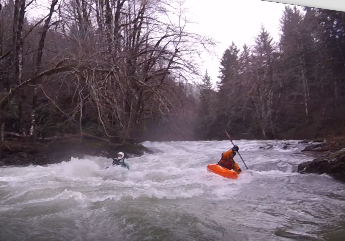
Stream: This is an interesting creek in Oregon's northern portion of the coast range.  Access is made difficult by private land, but it is possible to run if you are looking for adventure not far from Portland.  The run reminded me of an extended version of Hagen Creek, with lots of little ledges... 


                                                            ...some taller drops thrown in...

                                                        ...a few challenging boulder gardens...


...some enjoyable boogie...


And a true coast range feel.


Scouting is reasonable, and it's typically pretty easy to move along the bank.  Though the eddies can be small at good flows.


Since the kind of people who would do this run are going to be the adventurous type, I'm going to leave it about there with my description, and let the mystery be the appeal.  Below are just a few notes I would like to share with any potential future paddlers of this run. 

  • Walking around on the banks is pretty easy, and so is portaging for the most part.
  • The eddies tend to be small at good flows.
  • Aggressive boat scouting could get you into trouble on this creek, I recommend scouting for the next eddy on this run, and definitely blind sections. 
  • While the obvious option is to do the run as a day trip, a less obvious option worth considering would be to do it as an overnighter and take out way downstream on the Trask.
  • There was wood present, but it was cleaner than I had expected.


----------------------------------------------------------------------------------------------------------------------------------------------
Story/Notes
----------------------------------------------------------------------------------------------------------------------------------------------


Priscilla and I did this during the first large rain event in November 2021.  She was going to get hip surgery the next month, so she wanted to get one last adventure in before being idle for 3-6 months (the doctor said she wasn't going to be able to make her hip any worse than it already was by doing something like this).

We were impressed with the quality of the streambed.  If access was easier, it would be bordering on classic quality.

We ended up not finishing the run, both of us were injured so were moving slow, and the run had enough going on that we were just overmatched on this day.  We both hope to return with healthy bodies some day and get to paddle more of the rapids we walked around.  As it was, we had a somewhat harrowing and trying hike out.  Highlights from that 600' vertical bushwhack out in the dark include Priscilla throwing up from pain, and myself climbing an exposed section of cliff just before reaching a logging landing (which Priscilla also had to climb, but with the protection of a rope).  From there it was 4+ miles of navigating logging roads back to our put in car, where we slept.  Priscilla said it was the second most painful thing she has done (just behind the hike out that tore the labrum in her hip).

Our hike out route.


I returned the following week to retrieve our boats.  I wanted no part of hiking in the way we had come out, so used LiDAR to find an old road grade not visible in imagery or topo maps. 

Bare Earth.


I was happy is was predominantly fern-covered, and not slash-strewn.


 I was able to get back to where we had hiked out, crossing the creek twice where bridges were no longer where they once were.  My IK was mostly deflated after a week in the woods, so I pumped it up and headed downstream.


 I paddled my boat out first, then hiked the same route back up to get Priscilla's boat.  There was only one significant rapid, which proved to be fun once a log was relocated.


The rest of the run was pleasant floating in a small gorge down to where I had parked.


On the drive home I scoped out access to the headwaters of the Tualatin, and another obscure run made it's way onto my list.


Access:  The current access situation is the limiting factor for this run, gates mean that there is a minimum three mile hike in.  Because it is somewhat complex, and because this run typically flows during the short days of the year, it is important people get the logistics right.  For this reason, I am going to give pointers that will help people research their own way in, rather than a full description, so that people are required to make their own plan and gain a good knowledge of the area before attempting the creek.

Take Out:  45.4654752492765, -123.46132099884476

Beginning of hike:  45.501384861467244, -123.4001576886222

Put in for class IV(V) run (lower put in):  45.51780835808607, -123.41947900612611

Put in for class V run (upper put in):  45.527327100594945, -123.41976781430597
   *there is even potential to put in a little higher


Priscilla came across this handy map, we found it accurate in 2021.


This shows the route we hiked in along. Blue dotted line is road hike.  Yellow dotted is bushwhacking.  Yellow solid is spur road. Orange line is an upper put in option.


If snow wasn't an issue, there is another option to get to a put in from highway 6 along the Wilson.  If I did that, I'd make it into an overnighter, and take out much further down the Trask to reduce the shuttle length, which is longer than the way Priscilla and I went in.  

Here is that alternate put in route: 
 

·         Turn off HWY 6 at Rogers Camp

·         University Falls rd

·         Saddle Mountain rd

·         Cedars rd

·         C Line road

Stimpson gates don’t start until C line road, and shouldn't force a hike until about here:  45.54105493489647, -123.40831600136421 


Flows:  There is a unique rock at the take out that works as a visual indicator for the run.  The area around it would be prone to change in a large flood, but the rock serves as a convenient indicator for now. 

Looking downstream from the bridge at the rock.


The rock has two fins.  If the lower fin (pink arrow) has no exposed sections, the creek can be paddled.  If there is little bit of water going over the upper fin (blue arrow) the creek is at a great flow.  If the upper fin is making a hole or wave, the creek is high.  Due to the nature of the creek, I would not personally want to run it at high water.  


There are some correlation gauges in the area.  For a return trip I'd like to see Scoggins Creek over 200, the Trask River over 3,500 and the Wilson River over 5,000.  However those are just estimates, here are the graphs with color-bars coordinating to the previous photos of the rock at the take out.


Thursday, February 24, 2022

WFNF Wilson


Photo: Pete Giordano


BETA
III-IV+(P) /// 2.5 - 8 miles


Stream: This creek was an adventure Pete Giordano and I went on just before the pandemic arrived.  Snow levels had been high the day before, yet while we were running shuttle that started to change, we were thankful my dad would be running shuttle to keep us from stressing about if the put in vehicle would be snowed in by the end of the day.

Access ended up being good, no gates, decent logging roads, followed by a short bushwhack.  The creek started off small, and blind.  We had a few scouts early on, and one portage for a sieve.

Some scouting early on.

A quality rapid early on.
Photo: Pete Giordano

The creek was a bit immature near the top, and while there was some fun stuff, there was also some weird stuff.  Yet a favorable wood situation made the adventure enjoyable, and kept the pace up.


The further we went, the more water we got.  It was interesting starting on a micro-creek, and ending on a high water Wilson River.


Boogie


I figured that as we went further, and the gradient lessened, the rapids would get dull.  However with the seemingly ideal water level we had, there were enjoyable rapids throughout.


We did have some wood to navigate, as well as an old bridge that was creating a rapid we scouted.


Around the time we reached the NF, my dad joined, along with his friend Linn.  I switched out of the IK and into a hardshell.


The North Fork Wilson was pretty fun at this flow, certainly worth doing on it's own, even for non-adventurous boaters.  


Even with our healthy flows, there were still eddies were you'd want them.


Once on the Wilson, there is one last rapid above the take out bridge.  It had a hefty, but forgiving wave the day we were there.


The WFNF > NF Wilson > Wilson run was a nice, full day adventure.  The WFNF was relatively low hassle for a creek of it's size.  I'd go as far as to say I'd suggest it for that certain type of boater who likes to get off the beaten path on high water days, given how close it is to Portland, so long as they don't mind getting in and out of their boat a lot.  

As far as the NF Wilson goes, I'm surprised I don't hear more about it.  It seems like a quality, high water class III-IV option.

  
Flows:  We were there January 11, 2020.  I'd call the flows we had ideal, a filled in medium.  For a return trip, I'd look for between 5k-10k on the Wilson.


Wilson River peaked at 7500 cfs


Access:  We took out at Jones Creek Day use area, just half a mile downstream of the Lee's Camp Store off Hwy 6.  

There were no gates and the roads were decent on the way to the put in, but they do get up to about 2500' in elevation, so be sure you have a good idea about what the snow situation is before heading out there.

Just north of the bridge over the Wilson near Jones Creek Day use area, we turned right onto NF Wilson Road.  1.5 miles later we turned left onto Diamond Mill Rd.  If you are looking on a map, following Diamond Mill Rd for 6.5 miles gets you to the spur road (off to the right) we drove down towards the WFNF as far as we could go.  On the ground though, about 2.3 miles after turning onto Diamond Mill, we went to the south of a small peak rather than north, which can be seen in satellite imagery (but currently google maps doesn't recognize it).  Per usual on this type of run, cache the shuttle route on your phone if you are going to try this.

From the spur it was a relatively short and easy 300' bushwhack through ferns to the creek.

Where we started our bushwhack:  45.63196869089631, -123.6224198404706

Take out:  45.587711428206205, -123.55490891371407

This shows the section we ran in blue, and shuttle route we took in yellow.  The black circle indicates where the run changes from the WFNF to the NF Wilson, and about were my dad and Linn joined us.


Tuesday, October 26, 2021

Southwest Oregon Streams

Indigo Creek


The streams in the southwest portion of the state are some of the most special streams I have been able to paddle and spend time around.  Priscilla has been doing work with others who find the area worthy of protection.  

Some of these rivers are accessible to most everyone who has their own gear and ability to navigate the terrain and whitewater.
Camp on the Wild & Scenic Rogue River


Others require planning, effort, and luck.

North Fork Silver Creek


Below is a compilation of some of the whitewater rivers and creeks in the region that are paddled, click on the name to learn more about each stream.


--------------------------------------------------------------------------------------
Siskiyou National Forest
--------------------------------------------------------------------------------------

Box Canyon Creek (Kalmiopsis)

Briggs Creek

Canyon (Kerby)

Carberry

Chetco

Elk River

Lawson Creek

Lobster Creek

NF Silver

Pistol River

Rogue; Wild and Scenic

Rough and Ready Creek (via SF)

SF Chetco 

Woodenrock Creek

SF Coquille: Above the Cataracts

SF Coquille: The Gem

SF Coquille: Hwy bridge to Coal Creek

SF Coquille: Coal Creek Canyon

Silver Creek

Taylor Creek

WF Illinois

Whiskey Creek


Illinois River


--------------------------------------------------------------------------------------
Umpqua Drainage
--------------------------------------------------------------------------------------

Big Bend Creek

Black Rock Fork (South Umpqua)

Calapooya Creek

Calf Creek

Cavitt Creek (Upper)

Cavitt Creek (Lower)

Copeland Creek

WF Cow Creek

Elkhead Creek 

Emile Creek

Fish Creek

Jackson Creek

Limpy Creek

Little River

South Umpqua


--------------------------------------------------------------------------------------
Other
--------------------------------------------------------------------------------------

MF Coquille


There are a few places we have come across that are unlike anywhere else we have been - some of the most spectacular being located in the Illinois drainage.

Indigo Creek 


If you have the means, this is a great area to go paddling in.

Thursday, April 22, 2021

New River Hazards App for Oregon


The Oregon State Marine Board Board (OSMB) has worked with American Whitewater to create a new river obstruction tool for Oregon boaters. This will allow boaters to check for known hazards before paddling rivers in Oregon. The main objective is to address woody debris, if there is another type of unique hazard that you feel is worth tracking, do feel free to report it.


If you are a whitewater boater and would like to view and contribute to the map, follow this link: Oregon Boating Obstructions HUB


You will be able to toggle between “Current Obstructions” to view the map, and “Report An Obstruction” to contribute. To contribute, scan the QR code to download the free app (no log-in needed).


Feel free to send Priscilla (priscilla@recreate-consulting.com) or myself (jacobcruser@yahoo.com) feedback or questions to pass along to the Marine Board. Or, feel free to send an email directly to Brian.PAULSEN@oregon.gov.


What is potentially the largest woody debris pile in an Oregon stream, on the Big Dog section of the Collawash.


Friday, January 8, 2021

Indigo Creek

Photo: Zach Collier


BETA
8+ miles // IV-IV+ (P)


Stream: Indigo Creek is yet another high quality tributary of the Illinois River, entering from river right 3 miles above the take out at Oak Flat.  Many a boater have floated by on the Illinois, looked upstream and considered what lay up there.

The barrier to running this creek is logistical.   The access road "Bear Camp" goes up to an elevation of almost 4800', making it rare that there is water in the creek, yet no snow on the road.

After watching conditions for a few years, and passing up an opportunity or two in the middle of Winter (we were going to run the creek as an overnight trip), there was a unique opportunity late in the spring of 2020 after the snow had melted, in the form of a large, warm rainstorm.

Priscilla, Joseph and I added to the complex logistics by starting our trip off with a run down the Illinois, and meeting the other half of our group at the take out for the Illinois, setting shuttle and heading straight up for Indigo the next day.


Joseph Hatcher, Kory Kellum, and Dave Formolo at Collier Creek camp along the Illinois.

Aside from having a nice trip down the Illinois, we had the benefit of being able to check water levels on Indigo as we floated by, and walking up it a short way. 


It looked like enough water to us, but on the low side.  We continued to the take out, said good bye to the Illinois group, and hello to Ben Mckenzie and Yann Crist-evans, who would be joining us as part of the Indigo group.  

We camped at Oak Flat that night, amid a soft rain that we crossed our fingers would keep levels on Indigo from dropping much overnight.  The next morning we drove up towards the put in to meet Zach Collier high up on Bear Camp Road.  We were pleased with how the logistics were working out, given they had been put in to action 3 days before and there had been no cell contact since.  Zach had found the put in road to be un-gated on his drive up, so after stretching our legs we drove down to NF-2411 and began a descent into the Indigo drainage.  We were happy we hadn't been stopped by a gate, but these old Kalmiopsis roads are always hit or miss as far as their condition, and usually come with their own set of obstacles.  We were glad we had a chainsaw along, and Joseph was making good use of it clearing the path.  We would have had a long walk without one.

The end of the road, and the beginning of the hike.  We had all been prepared to get stopped early, and hike further so were in good spirits when we realized the hike would be less than a mile, rather than the potential for over 5 miles if the road had been impassible.


The walk in was pretty cushy for a 1,000 vertical foot cross-country descent, moving downhill at an easily walkable-able grade with stable footing through a recently burned area with minimal brush.Photo: Priscilla Macy


We were aiming for the confluence of the EF of Indigo Creek, and Breezy Creek as our put in.  The last 50' to the creek the hard shellers lowered our boats with a rope, though Zach found a different way down with his packraft that didn't need any rope.  We found ourselves at water level about 50 yards upstream of the Breezy confluence.Photo: Priscilla Macy


We had chosen the East Fork as our access to the drainage and were glad we did, but would probably choose a different route next time.   There are cross-country routes to the West Fork, or nearer the confluence of the EF/WF Indigo. 


----------------------------------------------------------------------------------------------------------------------

You can read about our trip down the East Fork of Indigo Creek here.

-----------------------------------------------------------------------------------------------------------------------

*keep scrolling for Indigo Creek

Photo: Priscilla Macy


------------------------------------------------------------------------------------------------------------------------

Back to Indigo Creek.

-----------------------------------------------------------------------------------------------------------------------


We woke up after a wonderful day of problem solving on the EF of Indigo Creek, and a nice night camping at the confluence of the EF/WF Indigo Creeks.  We started the day pleased that the water levels had not dropped much, but displeased to discover cracks in both Priscilla and my boats.


Fortunately, we had Ben Mckenzie with us, of the Mckenzie Method, the next evolution of the Waley Weld.  He was able to guide us through the finer points of the method, and we had patched our boats well enough to get us through this trip and a week in Cali using duct tape, a butane torch, and an awl Joseph has on his multi-tool.
We put on and the additional flow from the West Fork was immediately noticed.  Instead of bouncing down rapids, we were floating through them.  Pretty quickly the whitewater got fun and we found ourselves in a groove of read and run class III and IV rapids.


 The rapids were high quality, and our smiles were getting big.  The rapids were of a read and run nature with nice boofs, chutes and ramps weaving between vehicle sized boulders with good visibility, plenty of eddies and easy scouting when needed. 
Photo: Zach Collier


 Part of the reason Priscilla was excited about doing this trip was this creek is proposed as Wild and Scenic, so she wanted to get some photos to help with that campaign.  And while every corner provided a photo opportunity we were all having such a good time it was hard to take a moment to stop.  We would go 10-15 minutes while catching only an eddy or two and realized if we wanted some photos we were going to need to make a conscious effort to do so.

We took a short lunch break below this notable rapid, which we scouted and set safety for.
Photo: Zach Collier


Every now and then we would come to a larger, or blind rapid where one or more people would hop out for a look.  These all proved clean as well and provided more good fun, I'd expect a couple of them to become class V at higher levels.


What really stood out was the sustained, quality read and run.  By the time we were half way through, we knew this was a special trip and creek.


After a few miles the creek transitioned to a more open stream bed, and the gorge walls were left behind.  The rapids remained down here, though they were less frequent.  We enjoyed this section too, and eased in to the new pace.


There were a few campsite options now that we were beyond gorge walls, the best we saw was here:  42.49520480965567, -123.92883884785915

The most significant rapid was also in this stretch, formed by a landslide.  We were able to scout from the right, and most of us ran the rapid, while a couple portaged right.  There were a couple hazards and a tricky move.
Photo: Zach Collier


The rapids continued downstream, in a greener setting, and distances between rapid sets.


A couple miles above the take out, the creek eases to cobble-bars for a mile or so as it weaves through Indian Flat.  This let us know we were getting closer to the end of the trip, and we started chatting about the final obstacle we knew awaited us.  We knew this obstacle was there because there is a trail that accesses the last mile or so of the creek, and Zach had hiked in to where a bridge crosses over Indigo some time ago.  He had noted what was likely to be a portage, where a big landslide had dropped loads of boulders in a mess down at the creek.


Paddlers will know they are approaching the portage when the bridge visible in the photo below becomes visible.  The rapids above and under the bridge are runnable down to a moving pool.  


We then ran the first part of the landslide rapid into an un-welcoming eddy on the left, for a short teamwork portage.  I would recommend anyone running this creek to be patient and thorough from the point the bridge is in view, to below the portage.  Everything is manageable, but mistakes here would not be forgiven.


Below the landslide, fun boogie continues down to the final straight-away into the Illinois.
Photo: Zach Collier


A happy group at the confluence with the Illinois River, as Zach takes the last stroke of the trip on Indigo Creek.


Across from Indigo is a wall of pitcher plants, then a few miles of easy floating down to the take out at Oak Flat.


Flows:  We paddled Indigo Creek May 18-19 of 2020.   

I typically look for the Illinois at Kerby gage to be between 3-10k and stable or dropping for the Illinois tributaries to be at a good flow.  However there are times (like on our trip) where significant storms give water to the lower Illinois tributaries, but those storms don't make it past the mountains into the Illinois Valley where the gage is, and it reads low.  In the past you needed to rely on a good sense of the area, and see if the Chetco or Elk River had plenty of water to make a judgement call.

Fortunately for boaters, a new gage has gone in on the Illinois near Agness.  Currently it is only available on the northwest river forecast center map, but hopefully will be accessible in other formats in the future.  I'm looking forward to getting a good feel for that gage.


Looking upstream from the Illinois at Indigo Creek the day we paddled it. Note the rock with the circle around it.

This is that same rock zoomed in, note the "cup" in the middle of the rock, and that there is a trickle of water floating through it the day we did the creek.  I would definitely go back at the flow we had, though I'd want at least as much water as we had to put the effort in.  So if the riverbed doesn't change too much, you'd want to see water floating through the cup to make a trip into Indigo.  


The creek could definitely handle more water than we had, but I have no idea how much more before it became a class V run.


Access:  Access to a put in is difficult for Indigo Creek.  Options are abundant, but all spur off of Bear Camp road and require driving to 4800'.  Snow will typically be the largest barrier to running this creek in any given year.  

We started on the EF of Indigo, using NF-2411.027 to get close enough to go cross-country down to the confluence with Breezy Creek (42.54022150693661, -123.82644430527772).

If I were to do the run again, I would put in on the West Fork of Indigo, bushwhacking down from FS 2300.055    If I wanted to do another overnight, I would put in near Lazy Creek (42.55286705698742, -123.8562727687666).

If I wanted to do the mainstem as a day run, I would continue further down FS 2300.055 and put in closer to the confluence with the EF (42.51795927253282, -123.86370156281572), or maybe upstream off of this spur (42.53401209748882, -123.86334084891905).

The take out is fortunately very easy to find, at Oak Flat on the Illinois (42.516888209583165, -124.03946594559478).


----------------------------------------------------------------------------------------------------------------------------------------------
Story/Notes
----------------------------------------------------------------------------------------------------------------------------------------------

Priscilla, Zach and I reminisced about our trip down Indigo Creek on a podcast, you can listen to that here:  Rivertalk Podcast