

Photo: Chris Arnold
BETA
Stream: The Lower Wind is a Summer time staple in the Columbia River Gorge, as well as a fun trip to do in the Winter. This page describes the run as it is most commonly paddled, in the Summer at flows around 100 cfs.
The people who live at the top of the put in road don't really dig people driving past there house. Adhere to their wishes and drive very slowly until you are past the houses.
There is a quarter mile of class II and a nice pool to warm up in and do some rolls before entering High Bridge rapid, a 1/4 mile long rapid that is bouldery and technical at low water. If you have a good attitude and good boat control weaving in and through the rock piles can be enjoyable, if not you can take the opportunity to let everyone else in the group know how elite you are by complaining about how "boat abusive" and "manky" this part is.
A short distance below the end of High Bridge rapid Panther Creek comes in on the left and adds some water to the stream. Read and run class II-III is the name of the game for awhile below here, as you learn the run you will develop preferred routes through each of the rapids.

After passing a rope swing on the left (I don't suggest using it) the river consolidates and bit and goes through a couple III+ rapids that feel different than the rapids upstream before a small pool and horizon line signal that you have arrived at The Flume, which should be scouted and possibly portaged on the right. The rapid looks straight forward, yet an obnoxious rock just below the surface in the center of the first ramp keeps people from running it sometimes. Class III+? Class V? It has been called both, look at it your first time down.

A couple small, but enjoyable rapids separate the Flume from Beyond Limits. There is a fish ladder on the left that is to be avoided, and a fun ramp on the right side of the river, or a mediocre boof all the way on the right wall. It is easy to take a peak beforehand from a bench in the center of the river.

Another section of read and run III-III+ leads to a straight away with a foot bridge spanning the river that signals the approach of Shipperds Falls, the main event. Stop well upstream of the foot bridge if you intend to scout. There is a confined fish ladder on river left with an avoidable, but dangerous intake. Just upstream of the fish ladder is a class III-IV, 4' ledge. After going over the ledge, move right into a friendly eddy your first time. From there you can ferry back to river left to a smaller eddy to scout the falls, or scout the falls one at a time. If you are following people who know the run down, its not uncommon to run all the drops on verbal beta (Shipperds is a class IV rapid by the end of Summer).
The first falls has many line options, and with an eddy at the lip they can be mixed and matched.
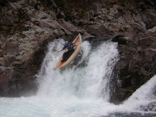
Nick Hymel with the rail grab.

The second falls is powerful and can be hard to get a good boof off of. While there are numerous techniques for running this drop, I feel the safest bet for first timers is to have some right angle to assure you end up in the nice eddy over there after landing.
The third drop looks janky, but if you run just to the right of the largest roostertail pointed at 11 o' clock it is generally quite fun.
Stop before going over the low head dam and ferry over to a small eddy against the retaining wall on the left if you want to hike up and repeat, the ease of doing laps on this falls is an incentive for doing this run. I have heard of motivated locals exceeding 20 laps in a day.
When you have had your fill, plop of the lowhead down through the notch on the left side. I like a little right angle here to avoid being pushed into the left wall, the hole is no problem if you keep your nose up.
From here it's read and run class II+ to the take out, with the bonus of a number of hot springs on river left, the one most commonly used by kayakers is 1/4 mile downstream of Shipperds, with the falls still in view.
The take out is marked by powerlines crossing the stream.
Flows: This run may never get too low, though below about 80 cfs you may notice you don't see others on the river. Over 150 cfs Shipperds is a little less friendly and at some point it becomes a no-go (it's never been run at Winter Flows to my knowledge).
Access: Cross into Washington over the Bridge of the Gods. A toll of $1 existed in 2015, with talk of that price going up in the near future. Head East on Hwy 14 for 5.8 miles (passing through Stevenson) and turn left at a flashing yellow light that takes you up to Carson. At the stop sign in town turn right onto Hot Springs Ave. In 0.9 miles turn left onto St Martin's Rd, then make an immediate right onto St Martins Hill/St Martins Springs Rd. This dirt road leads down to the take out.
Return to the stop sign in town and turn right onto the Wind River Hwy, in 2.1 miles turn left onto High Bridge Rd (there are many similarly named road in the area, so the odometer setting is especially helpful here). Take the first right off High Bridge Rd and follow through the neighborhood, driving very slowly as soon as it turns to gravel. Follow this down to the obvious put in site.
No comments:
Post a Comment