Showing posts with label falls city. Show all posts

Thursday, April 10, 2014

Boulder Creek; Siletz drainage


BETA

Stream: While logging is an important and necessary industry in our state, I often wonder what Oregon's Coast Range might have looked like before Big Timber got ahold of it.  

The Valsetz region of the Coast Range is one of the most heavily logged areas in Oregon, but there is one watershed in this area (Boulder Creek) that is still on public land and remains largely unmolested near creek level.  Access is tough, and the run is challenging so not many boaters get in there.  For those that do and have the capacity to appreciate the place for what it is, it is a special trip.  

The ideal put in for Boulder Creek is at the confluence with Bridge Forty Creek, though access to that area is not available to most.  A lower run starting near the confluence with Little Boulder Creek is the likely alternative.  The run starts near Bridge Forty pretty small with some class III-IV and wood.  Within the first mile the stream becomes a sheet of bedrock and turns to the right, at this point eddy out left to scout Boulder Creek Falls.  This big falls has been run twice so far by Matt King and Ben Mckenzie.  The lead in is intimidating and the right side lands on rock.  The whole thing drops about 50' including the lead in.  Aside from the intimidation it has a good line and landing zone.

Matt King is in there if you look close.


Below the falls things clean up a little, with many class IV(IV+) rapids and continued wood hazards.  The further you get downstream, the better the rapids become and the less wood there is to deal with.  The best section is downstream of the confluence with Little Boulder Creek.  

Give yourself as much time as possible on this one, you are in a deep canyon for the second half and will be fighting daylight regardless of how smooth your run goes.  Bring food, water and your sense of adventure.
  
Flows:  You need at least 4,000 cfs in the Siletz for enjoyable levels, 6,000-7,000 cfs is a nice medium.

Access:   The section from the confluence with Little Boulder Creek (44.933920, -123.670526) down to the confluence with the North Fork Siletz (44.920561, -123.696239) is going to be the only section of this creek accessible to most boaters.  If you decide to do that run, I recommend continuing down the NF Siletz to this point:  44.892501, -123.716100 for an additional 3.5 miles of good fun on the NF.

If you want to check on current access, contact the BLM NW Oregon office and ask about access to The Valley of the Giants. You take the same route to Boulder as to the VOTG, crossing Boulder Creek less than 2 miles before you would get to the VOTG trailhead.

To get to the area, first cache the map onto your phone.  Google does not acknowledge the road along the NF Siletz as existing, so you will need to read your map the old fashion way once you reach the turn headed north up the NF Siletz.

Take Valsetz Road out of Falls City, or if it's a weekend you can drive up the Siletz from Moonshine Park.  Find your way along the logging roads to this turn, and head north: 44.878294, -123.708203  From this point Google Maps will not be useful.  Continue on the road, passing by the optional take out down on the NF Siletz here:  44.892354, -123.716192.

Continue upstream 3-3.5 miles until you cross the bridge over Boulder Creek.  Then, refer to the following map to access the lower section of Boulder Creek.  This lower section is still available to boaters most any weekend, and if coming in from Falls City on weekdays too any time fire danger is not high.
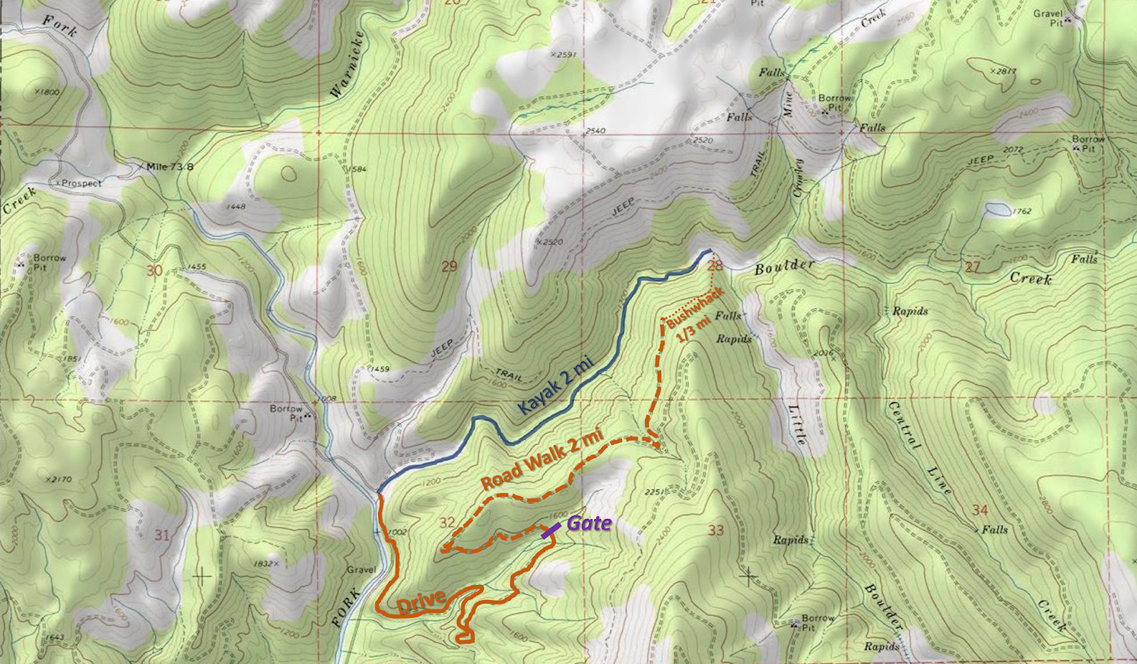


If you want to paddle all of boulder creek, putting in above the waterfall, continue reading.


"The Oregon Coast range is a mountainous version of the Bermuda Triangle.  Gates appear, open, and close randomly.  The famously incomprehensible road system is constantly evolving, so maps are only marginally useful.  Even those who are experienced in land navigation can soon be hopelessly lost without a GPS.  Tourists are regularly swallowed up by these mountains, and sometimes they don't survive the experience.  Needless to say, for those who love adventure, this is a special place."

             ~Jason Rackley; Oregonkayaking.net

For the above reasons I won't be giving step by step shuttle directions.  A summer scouting trip for access is recommended.  If you try to figure out the shuttle for the first time the day you plan to run the creek, you will run out of light.   Valsetz road to the Valley of the Giants has historically been open to the public on weekends when there is no fire danger, expect every other road in the area to be gated and closed except during hunting season.  Though even that option may disappear in 2017. (2019: Valsetz Road is still open). 

Put in:  44.93, -123.6292
Take out:  44.9206, -123.6962

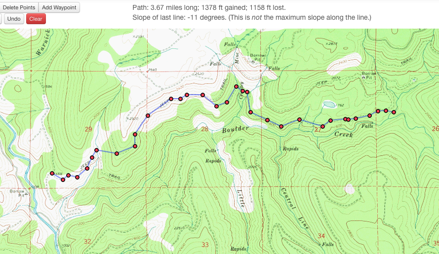
If you can't figure out the shuttle route, there is also the option to hike in from the take out along what the maps label as "jeep trails" along the north side of the creek.  Below are two maps showing those trails.


Click on the map to enlarge it.

The hike is under 4 miles, and after the first mile looks pretty flat.  I do not know the condition of the "jeep trails" other than that around the falls they are good for walking.  I would not be surprised if in some areas they were overgrown.


----------------------------------------------------------------------------------------------------------------------------------------------
Trip Report
----------------------------------------------------------------------------------------------------------------------------------------------


This was my second time down Boulder Creek in the Siletz drainage.  It is an enjoyable but logistically challenging class IV-IV+ run with a tough 50' waterfall that can be portaged.


Paddling in the dark can be very enjoyable under the right circumstances, or it can be very dangerous under the wrong circumstances.  This trip had a little of both.

The first time I did this run with Matt and Eric Harvey we needed to hike in 2 miles through the snow and had to charge on the river to get out before dark.

Photo: Matt King

Snow has a way of creating elegant situations.
Photo: Matt King


This time around everyone was once again pretty excited about running this rarely paddled stream.   All nine of us in fact ( a large but doable number given everyone knew most of the others pretty well).  The meeting time of 8:30 in Monmouth turned into not leaving Monmouth until after 10.

We were in good spirits on the long drive into the NF Siletz drainage.

We ran into another group of boaters doing what looked sure to be a fun run on the NF Siletz.

Shortly down the road we encountered a log across the road that we had beta would be there.  Dan had the foresight to pack a manual chainsaw.

  Time: 11:30   AM

We continued on and made quick time of leaving a car at the take out where Boulder Creek enters the NF Siletz.  We embarked on the long shuttle drive (a little under 15 miles on arterial logging roads).  We didn't need to resort to a map or GPS but having one in the trunk was a comfort.

During this period we encountered logs 2, 3, and 4 that required attention.

  Time:  2:00 PM


We reached the put in parking spot and did the 100 yard walk through the woods into Bridge Forty Creek.  Putting on we encountered a rapid that required scouting and safety.  The hundred yards from the top of this rapid to Boulder itself took 20 minutes due to the small tributary and many boaters.  It would be easy enough to walk straight to Boulder by veering left from the vehicles and skip Bridge Forty Creek.

First rapid, an interesting section of rock and water.

2:25 PM

Upon reaching Boulder it was apparent there was more wood in this upper section than the last time I was here with Matt and Eric.  Everyone started talking about the wood and getting nervous.  The first 200 yards of Boulder really set a precedent as people become timid about hustling downstream due to the abundance of dangerous wood in the creek.

It was not long before we arrived at Boulder Creek Falls.  Many people quickly decided to portage this tough drop.  In the end only Ben Mckenzie was interested in paddling the falls.  He took the same line that I had seen Matt take 2 years earlier which was a right to middle move.  Its a tricky lip with an even tricker and highly consequential lead in.  Ben greased the line.

3:15 PM


It was after 3:30 by the time we were paddling away from the falls and tensions were already mounting.  Below here the stream cleaned up significantly but the woody section from above the falls was still vivid in everyones minds.  We moved slowly through this section and scouted often for wood.


At one point Ben was easing himself under a tree that came loose and landed on him, requiring assistance to hoist it off.

As tributaries came in we started running some quality whitewater and spirits rose a little even as fatigue started to set in.

We had a pin that took some heroic action by Joe to rectify.  This pin put everyone back on their heals.

5:30 Finally Little Boulder came in on the left and I knew that we were in bad shape time wise with dark arriving at around 6pm, but the large group was finally getting into something resembling a rhythm.  We started moving a little quicker and the added volume was welcome, making for some pushy rapids and some holes.


There was a quarter mile long section of pushy boulder gardens that proved to be the tipping point from holding on, to nearing loosing it as a group.  I was chasing down an IK as I entered another rapid and chose to pass the craft instead of try to coral it.  Sam along with Ben arrested it downstream in the first pool we had seen in some time as I headed upstream to check on the paddler.


As I headed that way I saw another boat floating downstream along with its captain.  Ben and Sam once again collected our friend in the pool and the gear as I continued upstream.  The IKer along with two other paddlers made the prudent choice to efficiently portage this rapid.  By the time we were all moving again the light had changed as it was close to dark.

We were in what I remembered as the final gorge.  We had two wood portages in here, at the top of the first portage it was already 6 o clock, the time we had hoped to be off the river by.  We now knew every minute of light was more than we were counting on.

First gorge portage 6:10

After the second portage it was twilight.

Oddly enough, even after the obstacles we had faced and the lack of light, people pulled it together and for the first time we were really moving cohesively as a unit.  I looked back to see everyone in our team spaced evenly and charging ahead as stoically as they could muster.  Had we been moving at this pace and efficiency the whole time, light would never have been a problem.

As twilight faded we encountered the final boulder garden of the run.  I knew if we scouted it we would be running it in the pitch black and saw a line through it so I kept paddling.  The wood situation was worse at the bottom than I had been able to see from above or remembered and two people had close calls.  This was the hardest decision of the day, but I still feel it was better to boat scout the rapid with the last minute of twilight than to run it/portage in the complete dark.

It took a couple minutes to get the group back together and some team encouragement was needed to get everyone back in their boats.  People pulled themselves together for what I remembered as the last rapid (a slide into a hole).  Alex and Ben gave good beta and everyone came through well.

A minute or two after that rapid I took this video.


A ways below here I had a conversation with the unrelentingly positive Sam Causey where he pointed out how now that the rapids were class II, the setting was nearly romantic.  I knew what he meant and relaxed a bit on the 15 minute paddle from here to the take out letting the trip soak in.

Before long I started hearing cheers of joy as people saw the taillights of the take out car (Lucas had hiked back to the cars after breaking his paddle on the first rapid and was about to drive upstream looking for us.)

Everyone regrouped at the cars and the nerves and fear washed away instantly as relief began to set in.

The shuttle went smooth as could be hoped for in the torrential downpour, and everyone took turns recounting the days events.

While from the outside it is hard to see a trip like this as a successful one, those who have been in this situation know that you end up learning a lot about yourself and your friends and while you don't generally seek out that type of ending, there is still a lot to be enjoyed.  On this trip everyone on the team had their roles and executed them when they needed to, Go Team!

  I thought we had got away with one on this trip, little did I know Boulder Creek had left me a little surprise for later that week.


Daylight savings will be a welcome extra hour of light in the evening.

Flows the day we were there averaged in the mid 6k range on the Siletz.

Happy Adventuring,

      -jacob


Thursday, November 14, 2013

North Fork Siletz

The North Fork Siletz is kinda out there so it gets less traffic than some of the more popular runs around Oregon.  It is unfortunate more people don't make the trip because it really is a cool drainage.

The drainage has 4 runs that have a reliable rain fed season.  The North Fork Siletz itself is about as classic as coast range runs come and is what this report will focus on.  The more adventurous runs are described elsewhere on this blog and the internet at large.  The main section is all roadside, has great water quality, 3 bedrock rapids of the class IV-V variety (easily portage-able) and miles of III+ splashy goodness. The area also boasts some of the largest trees in the coast range and you drive through the site of Valsetz if you come through Falls City.  When this town was a thriving logging community, it experienced more days of rain than any other city in the contiguous United States.  The town has now been reduced to a couple foundations.   Every time I visit the Siletz headwaters area it reminds me why I like kayaking so much. 

Photos from Lucas Reitmann and his Gopro.


The run has a write up on Oregonkayaking.  They run it at flood, and this report is at low water.  Most people will shoot for something in between.

At flows above 5' on the Siletz gauge, the best put in option is to walk the short Valley of the Giants trail to a footbridge and put in on that fork.  Within a hundred yards you will be at the confluence with Warnicke Creek and if the gauge is over 7' you will have an enjoyable III+ ride down to the Boulder Creek Confluence.

The photos on this page were taken with the gauge was at 4.5' and we decided to put in on Boulder Creek, about 1/4 mi above the NF confluence.

Below here are some small rapids before reaching the first ledge.  This is the ledge described on the Oregonkayaking report that only Jesse Coombs ran.

At the lower flows we had, it is a benign slide in the middle, or a slightly less benign ledge on the left.  The rapids below here remain small, but the bedrock is intriguing and there are some minor eddies and waves to play in.

Eventually there will be a left turn towards the road, the river then turns right and enters Bombshell Gorge.  It is worth scouting and setting safety on the left.  At 7' on the gauge the first hole is sticky looking.


Lucas enters Bombshell

On our trip at 4.5' there was a sneak route on the left or a tricky twisting ledge drop on the right that produced a couple rolls.


Gabe drops a Bombshell


Victor with an exciting line.


 Below here is a twisting drop and then a hole that might be worth setting safety on.  The easiest way to do this is to have a confident boater run it first and get out on the left.


The small, but sneaky pocket hole in Bombshell Gorge.


Easy pool drop rapids continue below here until what has been referred to as the recommended portage.  It would be possible to unknowingly enter this unassuming drop from above so its worth familiarizing yourself with the area on the shuttle.  We scouted for awhile and Lucas said he wanted to run it but like the rest of us was worried about there being a rock in the chute.  Priscilla and I paddled over to river right and got a big stick.  We probed the depths a few times and determined there were no obstructions hiding beneath the surface.

Lucas then decided to give it a go. He came in and submerged briefly before riding out a tailstand in his Dagger Axiom.


 It was an inspiring line.


  Inspiring enough in fact to start to make the rest of us interested in the drop.  Victor was heading up to his boat almost immediately after Lucas came through.  Lucas called across the stream that it was good to go and we should give it a shot.  Victor then floated into the chute, also submerging and coming out upright.


Recommended portages are often of the grandiose variety.  This one is a compact model.


I followed Victors approach and floated into the chute, letting the water funnel me into the deepest part of the channel and using a rudder stroke I skipped through like everyone else.  Lucas was quick on my tail for a second lap and came through this time without even getting his head wet.  It looked to me from downstream like he drove harder right and took a big stroke.

We took out here and Lucas did the scooter shuttle.  While standing around it was decided this drop should have a name.  It has only been referred to as "the recommended portage", but given Lucas's volition to go first, along with a second successful attempt we devised a name that we felt was ever so clever.

We dubbed the drop "Go Reit, mann"  as the line is to go right, and Lucas's last name is Reitmann.  

 Lucas fire's up "Go Reit, mann" again.
As Nate later pointed out, it's best said in a Jamaican accent. 


There is even a bonus side slide.

Video of the day from Lucas.


NF Siletz from Lucas Rietmann on Vimeo.


 ~1000 cfs is the minimum for this run, 5'-7' on the Siletz gauge provide ideal flows.  If you are looking for a more full day with plenty of class IV(V) and the level is over 4,000 cfs (7ish ft) check out Warnicke Creek.  You can start above Golden Goose and run through Go Reit, mann for an extended day of very fun boating.  Lastly, if water is super high, a combo run of this and the south fork is worth looking into.

   -jacob

Thursday, December 27, 2012

Little Luckiamute: In to town


BETA

Stream: This section has a write-up in the back of Soggy Sneakers but gets little attention.  It doesn't have the best whitewater, but it does have whitewater and is roadside.  I ran it a number of times while I was in college because it was close by and I could jog/scooter the shuttle between classes.  If you are a class V boater the drop below the take out might interest you.

I usually started at camp Tapawingo, but it is possible to start at the white gate at the take out for The Gorge section.  Below the Tapawingo bridge is a short bit of class I-II before the creek drops away through several steep and braided channels.  Sometimes the top had to be portaged.

Below here it's class III or IV depending on flow with some flatter parts.  Watch out for wood but there was never enough to bother me.  Before reaching a decommissioned park there is a steep rapid that is pretty intermediate at normal flows but on one high water trip it was not and the person I was paddling with took a heinous swim and lost their gear.  They were pretty shook up.  I'd rate the drop more IV+ that day with some real holes.

Below the park the creek eases off and it's splashy class III at high water and technical class II at low water until you pass under another bridge.  Below this bridge things build slowly back to class III-IV depending on flow and there are a couple ledges with solid holes at high flows.


Work right as you approach Falls City Falls, the eddies along the bank over there are plenty easy to catch but you wouldn't want to miss them and if you enter the lead in too far left you might not be able to stop above the Falls.  Fortunately it's easy to scout the take out before putting on from Falls City Falls park and I'd recommend doing that.

This is the end of the trip, but you won't be able to help but look for the line at Falls City Falls.  It's a pretty serious and messy drop, but if you decide to run it taking out at the foot bridge behind Fink's Market is easy.
  
Flows:  I take a look at Falls City Falls from the take out to gauge flows for the run, located here: 44.867172, -123.438568. 


Pat Welch has an online estimate, I usually look for 400-1,000 cfs for the Little Luckiamute to be in but have run it both higher and lower.  Iv'e paddled it a hair under 200 before.  If levels are rising I don't want to see that gauge above 500 or so though, in fact if levels are rising fast I usually avoid this stretch. This river doesn't get more fun, just more stressful at high water.  Rickreall or the main Luckiamute are better high water options that are nearby.

There are three rocks at the falls that can help you get an idea what kind of flows you have.  
-  If flows are going over the yellow (L) rock, you have enough water to paddle the river. 
-  If water is going over the blue (M) rock, you have good/medium flows.  
-  If water is going over the orange (H) rock, you have high water. 


Too Low


This was taken at a low, runnable flow. 
Photo: Adam Edwards


Medium


High water.  Iv'e put on at Camp Tapawingo twice at high water and it was stressful both times.  Priscilla had a life adjusting swim on one of those trips.  Using the lower put in makes this section more reasonable.  Watch out for some large holes in the half mile above Falls City Falls, and make sure you can stop above it.


I have not paddled the river this high.


Access:  Drive into Falls City Falls via Falls City rd, a short way past the High School and near the end of town is Fink's Market.  Pull in here to grab your food, water, beer, etc for the day.  Drive another 100 yards past Fink's and you will see a bridge, cross over the bridge and turn right. There is a small gravel parking area on the right in about 100 yards with some boulders and sometimes a port-toilet.  This is the take out, where you can assess flows and check out the eddy situation for taking out above Falls City Falls.

To get to the put in cross back over the bridge and immediately turn left, then veer left again in 1/4 mile.  The road becomes gravel, continue about 3 miles to a right turn into Camp Tapawingo/Black Rock Mt Bike area.  You will shortly cross the put in bridge where you will find ample parking.

* For a shorter/easier run once you hit gravel continue only 1.5 miles to what used to be a park on the right (but is blocked by boulders in 2018).  This can be used as a put in.


----------------------------------------------------------------------------------------------------------------------------------------------
Original Write-up
----------------------------------------------------------------------------------------------------------------------------------------------


Plan B: Falls City Falls

One of the first things I did upon arriving to college freshman year at Western Oregon University was to go check out the waterfall that was in the neighboring town of Falls City.  Driving there and asking locals to its locale I found it looking pretty marginal that day, but maybe at a different flow it would go?

I have returned to that falls many times since that first trip at all variety of flows.  I had never felt inspired to run it.

Last weekend my roommate Pat and I were trying to get to the Valley of the Giants, but got turned back by snow.  I figured we were driving right by Falls City Falls on the way back so might as well take another look at it.

I knew right away that it was runnable on this day, the flow was perfect and I had the feeling.  All I had was the IK, but sometimes I feel better in that thing anyway.  I scouted for half hour or so then had Pat drop me off half a mile upstream to warm up and remember how the IK handled.

Arriving at the falls I scouted for a few more minutes and then headed to my boat.

The line went exactly according to plan and can be viewed below.  I never thought I would run this drop and it was surreal to paddle towards it and then away from it.  Another personal boundary breached.

I think the online estimate was about 700 cfs and stable or dropping.


   -Jacob

Monday, March 5, 2012

Little Luckiamute: The Gorge


BETA

Stream: After a messy and steep bushwhack down to the creek (maybe 15 minutes?) you arrive at the creek.  The first 1/4 miles is on the manky side and while you want to keep an eye out for wood there usually are no portages.  It is important not to be too aggressive on this run, the first rapid (Catalyst) comes up quick and has been run blind on accident.  It is at the end of a bit of a straight away with a busy class III approach.  If you sense bedrock eddy out on the right ASAP and walk down the bank to scout this 15' ramp followed by a 6' ramp.  

Lucas Reitmann approaches Catalyst.  Notice where the boats are on shore, well upstream of the drop.  Once you see the horizon line, it's too late to stop.
Photo: Joe Kemper


The pool below Catalyst empties into the lead in to Osmosis.  So get out in the pool below Catalyst to scout Osmosis which goes around the corner.  The lead in starts as a series of small slides, then turns right and enters a narrow alleyway.  This alleyway culminates in a beautiful 30' falls.  Scout thoroughly on the right, if you decide to portage, schwack along the rim of the gorge until you are looking down at a grove of ferns descending to the stream and can see a small falls cascading off the cliff on the right downstream.  If you drop down too early the descent is more difficult and you will run into Devil's Club.  It is easy after the portage to walk up the bank to the pool below Osmosis for safety and media.


                                                                                Photo: Nate Pfiefer 

A short gorge section leads to the lip of Tough Luck, a nasty 30 footer with numerous problems.  If it was wood free it would be runnable but still V+.  My first time doing this creek Jeff Hartley and I did a throw and go off the right side, but the landing zone is very small and at healthy flows it would be easy to lose boats here. 

Since that first trip I have always portaged left by doing a sloppy climb up the wall and then roping boats up after.  Everyone after the first climber can then use the rope for assistance (recommended).

Below here there is only one good place to descend back into the gorge and it's not too obvious.  It's a steep draw overlooking Tough Luck and requires roping boats down and I usually double up a rope to assist my descent as well.  Once below the first pitch it's an easy walk down to river level at a gravel bar above the next falls, Little Lucky.  Little Lucky can be scouted easily from the lip on the right, and if need be portaged high on the right (only necessary if wood is present).  This 15' drop has two obvious lines, both are clean but I like far right best.

Below here is a short bit of semi-blind class IV, when it doubt run right.  The tough stuff is over at this point and the difficulty of the whitewater quickly fades with the gorge.

The left wall is worth paying attention to for the next mile as the marine deposit retains its grandeur but goes from a hard stone wall to a softer, sandier material the further downstream you go.  The whitewater is unremarkable and is manky if flows are low but it keeps moving along.  Near the end the walls disappear and there may be an easy log portage or two.  The runout is pretty long so if you are running short on daylight keep that pedal to the metal.

This isn't a classic whitewater run, but it's absolutely worth it and definitely a classic adventure run.  Osmosis Falls may be one of the finest rapids in Oregon.

If you are still feeling fired up at the end, keep your gear on and check out Falls City Falls again on your way out.
  

Flows:  Pat Welch has an online estimate, I usually look for 400-900 cfs with some buffer room (Iv'e gone as low as 200) for this section if flows are stable or dropping.  I avoid this river if flows are spiking.


When I get to Falls City I take a look at Falls City Falls to gauge flows for the run, located here: 44.867172, -123.438568


There are three rocks at the falls that can help you get an idea what kind of flows you have.  
-  If flows are going over the yellow (L) rock, you have enough water to paddle the river. 
-  If water is going over the blue (M) rock, you have good/medium flows.  
-  If water is going over the orange (H) rock, you have high water. 


Too Low


Runnable Low
This was taken at the lowest flow the gorge has been run, here is a video of Osmosis on that day.
The runout can be a bummer at low water.
Photo: Adam Edwards


Medium
Here is a video from a healthy medium flow.


High
I am not sure if it has been run this high, though I know the Lucas's (Glick and Rietmann) ran it pretty high once when they lived in Corvallis.  At the flow they were there they needed to portage Tough Luck from well upstream of the usual spot, keep that in mind if you want to push flow limits on this one.  I choose to stay away from this river if it's spiking, as it comes up fast, and there is always wood present.


Flood
I do not believe the gorge has been attempted at flood before. Here is a video of the falls at flood.


Access:   It is highly recommended you cache a map on your phone and bring it with you on the shuttle/hike since the road system is confusing and ever-changing.  At the very least bring a paper map.

Take Out: 44.869472, -123.510332

Put In parking: 44.869174, -123.556270

Driving into Falls City on Falls City Rd, you will pass the school and just as you reach the end of town stay right (left would take you over a bridge).  In 1/4 mile veer left onto Black Rock Rd, the road turns to gravel.  Follow Black Rock Rd 3.5 miles to a bridge and a white gate, passing by Camp Tapawingo and the world famous Black Rock Mt Biking area.  The bridge with the white gate is the take out.

**Whether the gate is open (on weekends during the hunting season) or closed (the rest of the time) dictates whether you are driving or hiking.**

                                 Photo taken during hunting season Oct 2016 at the take out bridge.


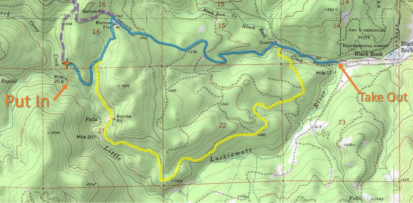
There are three main routes to get to the put in, they are delineated by color in the following map.


The Little Luckiamute travels from West to East
Click image to magnify


And some details from the put in area.

I like this route when hiking in through the clear cut.  Start down the dominant ridge, then cross left to the secondary ridge when reasonable and follow that to the stream.


BLUE (3.3 mi): This route is the most direct, but it's steep and high profile as most of it is on the Black Rock Mainline.  From the take out stay on Black Rock Mainline for 2.3 miles before making a left onto a small spur road, 0.4 miles later make a right onto a very small spur.  Half a mile later park and begin the hike down.


YELLOW (4.5 mi):  This route is the longest, but much less steep and lower profile so I prefer it for hiking and really it is best to drive this road to minimize visibility.  There is nothing illegal about kayaking back there, and keeping a low profile is a great way to keep it that way.  In February 2019 the bridge over Black Rock Creek was washed out, within 100 yards of leaving Black Rock Mainline, so it was not possible to drive this route.  Work is being done to restore the bridge.Cross the bridge at the take out and turn left in 1/2 mile.  Continue 3.6 miles and always choose the main/flattest/most straight option (don't go into the helicopter camp).


PURPLE (4 mi):  If you miss the spur road off Black Rock Mainline, you can catch the next left to get to the put in.

*It's also possible to take a route on the other side of the river using Valsetz Rd, then hiking Fanno Peak (gated) to a spur to a bush whack that people have taken when the gate was closed, but I'm not going to explain that route here.


----------------------------------------------------------------------------------------------------------------------------------------------
Original Write-up
----------------------------------------------------------------------------------------------------------------------------------------------

I had run this creek twice before, and hiked in a couple other times to scout.  After the first time I always knew I would return with the intention of running a beautiful 30' waterfall that was almost run blindly by Jeff Hartley on our first attempt of the creek.  That first time we were racing against darkness and had no time for a mishap or even to thoroughly scout the falls, sending us off into the woods for the portage.  The second time I returned, the water was low.  That second trip was about setting up ropes and scoping the run out for a return trip to run the falls with more flow and a softer landing.

On another trip Nate Pfeifer, Willy Dinsdale, and Brandon Bloomquist took me up on the idea to go back and check out the falls with the intent of running it.

We scouted the falls for awhile before Nate and Brandon decided to set safety for us, instead of running the falls which has a discouraging rock ten yards above the lip (gone in 2016).

I was concerned about the hit due to my tuck only making occasional appearances, but I really wanted to run the drop so decided to practice some mind over matter.  The lead in is a bit tricky so I was happy when my line went how I had envisioned.  I watched Willy have a great line as well only a few moments later making for a rewarding experience on the whole.

The team enjoys a special place!
(Photo Nate Pfeifer)


Nate Pfeifer did a write-up on the creek that can be viewed here.

2016 Update:  Catalyst and Osmosis are clean, the rock that was a nuisance just above the lip of Osmosis has rolled over and the alleyway leading into the falls is more straight forward as a result.

The following videos show the new configuration at Osmosis (0:50), and were taken at the best flow I have run the Little Luckiamute.
*Keep it muted at work or around the kids*
With Gusto from Difficult E on Vimeo.


This one also shows an alternate portage route at Tough Luck (3:00)


The wood situation was pretty good in 2019, just a couple easy portages in the class II-III stretch below the gorge.  The gorge was clean aside from Tough Luck.

Each year is different on this one as the levels get high, so wood cleans up or can land in bad places year to year.  I suppose that is all part of the adventure that is the Little Luckiamute.

     -Jacob


Monday, April 6, 2009

Little Luckiamute: Upper Access

BETA

Stream:  This part of the Little Luckiamute has too much wood for me to recommend paddling and the whitewater isn't very good in the upper parts so the beta will be sparse.  If you are looking for worthwhile trips on the Little Luckiamute check out The Gorge section or the Into Town section.

It's possible this upper section will clean up some day and who knows, maybe with more water it would be enjoyable to connect with The Gorge.  I'll let you read the original write-up below and decide that for yourself.

Access: The take out is the same as The Gorge.

To get to the put in return to Falls City and from the bridge in town head up Valsetz rd 9.3 miles to the pass at the intersection with Fanno Peak rd (yellow gate on the right).  Hike in on Fanno Peak rd for awhile, choosing your own route for where to descend to the creek.  Obviously you will need to do some map work of your own, the roads and bushwhacking scenario are constantly changing.

The map below shows two put in options, the one further downstream has been used as an alternate access to the gorge and only has 1/4 mile or so of janky rapids before the good stuff.  If it's hunting season you can come in on Black Rock rd, but if you are doing that I would suggest you just run The Gorge.  I'd recommend you do some of your own map recon before heading out there.


Flows:  I am not sure, we had 200 on the estimate which was too low.  

----------------------------------------------------------------------------------------------------------------------------------------------
Original Write-up
----------------------------------------------------------------------------------------------------------------------------------------------  

     The Little Luckiamute flows through the small town of falls city about twenty minutes from Western Oregon University. I was interested in checking it out mainly for this reason.  I ran the lower sections of the creek and began doing research on google Earth and waterfall sites to get an idea for what might be in the upper section and how to access it. After this I decided it was time to head over there and check out the access scenario. I soon found out this run, along with every other run I have looked at of this nature in the coast range is gated far away from any put-in locations for sections of substantial gradient. It was back to the map searching, which I spent plenty of time doing. I eventually decided that the best option would be to drive up Valsetz road and hike in 4 miles along Fanno Peak rd along logging roads to a bridge over the creek. On April 3rd Nate Merrill and I decided to give this approach a shot.     
           I had left my GPS back in Gresham for the weekend and unfortunately for myself and Nate I decided I could use a map to get in to the put-in since I had driven around there before and figured I could find the put-in road again. Due to a semi-stressful/late start we were dropped off and started hiking around 1:30 (way too late) on the wrong road. We spent the next four hours hiking with boats on our backs trying to find our way to the river.  At this point we decided even if we got to the river there was no way we were making through 3 miles of 200+ fpm river with a 2 mile class 2 paddle out, so we ditched the boats and decided to come back two days later. We hiked back out and luckily caught a ride once back to Valsetz, saving a trip in the dark 5 miles back to our car.         
           We came back Sunday April 5th with the addition of Jeff Hartley to get our boats, and if we were up to it, run the river.  Due to some unusual circumstances we were able to drive to within 2 miles of the put-in before we hit a patch of snow, had we gotten an earlier start we may have been  able to backtrack to another road and drive very close to, if not all the way to the put-in. Thank you to Gary Merrill for being so willing to help out with this mission even though he would not be boating. It was here that Nate made the wise choice not to risk being late to work at 8 and decided not to join us on this mission.  Jeff and I geared up and started our 2 mile trek to the river.                                                       -all pictures taken by Jeff Hartley  (except this one which was taken by Gary Merrill)

   We hiked to a point where we decided to bush wack down to the river.  It was here where once again Gary showed his great value to the trip by scouting out routes through the woods for us.  With the help of the two Merrills we eventually reached another logging road where they decided to head back home and Jeff and I committed to running the river.  We spent another 45 minutes reaching the "river" by way of crashing through a regrowth forest with lots of underbrush down a steep slope.  The "river" turned out to more resemble a low volume creek.  The last hundred yards to the creek were through a forest of Devils club (pride of the Northwest), before we waded across the creek, drank some water, and got ready to give this thing a shot.

                                                      Almost through the Devils Club                                                            View from the put-in
The first mile was more of a battle than a kayaking trip.  Jeff showed a fearless boat scouting technique that kept us moving along.  I was happy that he was there because I would have been out scouting a lot of the first mile, but he was confident crashing down some very steep boulder mank.  Most of the larger drops fell 10 feet through a pile of beach ball sized boulders.  There was one scary moment within the first five minutes where Jeff thought there was a route that wasn't there and got pinned sideways on a rock with all the water funneling behind him under a root wad.  It was not a good moment, and I was pretty concerned as I exited my boat and ran down to him.  It was not looking like he was going to be able to hold his position for long.  I ended up being able to get to him before the current decided his fate and all we ended up loosing from the ordeal was small piece of outfitting (from my boat oddly enough).
        
           He shaked it off like a champ and we returned our attention to downstream progress.  The most difficult part of these upper rapids was the water was low enough that each line had rocks throwing our bow off-line, which made them challenging when otherwise they may have been more straight forward.  I feel like I learned a lot about boat control on this trip.

                                                     One of the earlier rapids               There were a number of note-worthy rapids and had there been water and no wood, probably fun ones.  A telling scene occurred as I came down the far right side of a steep boulder jumble to avoid wood on the left, but got my paddle pinned between a tree branch and the bottom as I ducked said branch.  I let go because I felt the tension in my paddle and I still don't have confidence that my seven2 paddle is able to deal with much stress.  To keep from getting flushed downstream I reached up and grabbed a branch hanging down to stop myself mid-current, then spun around and pulled myself branch to branch to get back to my paddle.  Right around the corner was an ugly rapid that almost pinned Jeff that I portaged, then this mess.                        This was one of a number of times we looked downstream and saw this view.  There is heavy logging in the area and a lot of those downed logs had found there way into the creek.
It was shortly below here that we came to a series of large boulder jumbles in a row, along with some tributaries that signaled the upcoming waterfall of the run.  We started seeing bedrock poke up around the walls over the next 1/4 mile and every time I was sure the falls must be coming.  Eventually it did.  We scouted a sliding 15 footer that had a log across the top, which meant a portage for us.  Next was a 6 foot ledge, wondering if this would be the only real clean drop of the run, we lowered down a wall and ran it.
                                                                      The six foot ledge.  I got out on the right just below this ledge to take a look around the corner.  Jeff wanted to keep boat scouting as it was clear we were running out of light.  I insisted on taking a look, the long sliding rapid just below was blocked by a log halfway down.  After that it turned right into a narrow alleyway and exited via a 30' falls (a falls later ran and dubbed Osmosis Falls).  We just didn't have the time to contemplate the drop today so began a portage on the right where before too long we found a place to rope ourselves down after some bushwacking and ended up at the base of a towering cliff wall. 
                                                    It was here that we encountered our next clean rapid.  It was a small class two, but it was so nice to have a drop that held its water instead of bashing down a boxing match of water and rock.    Below here were some fun rapids and it started feeling like a real river.  There actually were a couple good quality class four drops in here.  A few hundred yards later we came around a corner in a close to vertical gorge and were confronted with a large horizon line.  I voiced my opinion that this better be runnable or we are screwed... It wasn't.  This drop fell 40 feet onto a rock shelf, then launched itself the next fifteen feet into an undercut wall and inescapable eddy on the left... uh oh.   Luckily the low water we had been bashing down for the last few hours allowed us to work our way down the river right face of the falls then jump 15 feet into a shallow, narrow eddy right next to the falls.  I went first since I had a drysuit so I could wait and collect the boats.  As I was climbing down I realized there was yet another horizon line downstream followed by a drop with a logjam in it.  The jump was a technical one and I brought my feet up as soon as I landed so I didn't go deep like I have done jumping into my pool off my roof before, then swam to a shallow shelf and waited.  Jeff threw his off which luckily landed upright and didn't get pulled into the undercut, I collected it and he was kind enough to lower mine on a rope.  He jumped in next and he mentioned afterwards that is one of the eeriest jumps he had ever done, I couldn't have agreed more.  We have both jumped off 50+ foot cliffs but the location of that fifteen foot jump and what it meant was just a little unnatural.                                     Jeff mugging for the camera at the top of the 40 footer As he was getting ready I cruised down to the next horizon line, which I dubbed little Lucky, because we were very lucky this was a small and runnable 20 footer(and the name I had nicknamed the river on all my google earth maps, short for Luckiamute), because at this point I knew we were going to run out of light, it was just a matter of how far downstream we could make it before that happened...                                                            Myself dropping Little Lucky.  Both of us had successful lines, we then had a quick river level portage below here, and then it was game time.  Jeff probed a small slide, and we began our race against time.  The first 1/4 mile was fun class 4 stuff, then it dropped to class 2 and I knew we had about two miles to go and the sun was going away fast.  Very quickly the sun disappeared and it was luckily a full moon or we probably would have been staying the night in there.  With the tiny bit of sun that remains at 8 oclock this time of year, and help from the moon, we raced downstream.  We were making really good time but we couldn't see anything but the white from the waves, so we had to guess where the rocks were based off what the water was doing.  This got scary when the logs started piling up, but we wanted to stay in our boats as much as possible to preserve what little light was left. There was one class 3 drop lit by the moon, then shortly below here we lost anything resembling real light.  
            Have you ever been told you can see stars better if you don't look right at them? And you can't see them sometimes if you look right at them?  I modified this technique to get downstream, treating the white-caps like the stars.  The log concern only grew as we went downstream, no longer obstructing every other rapid but still present.   We knew we must be getting close, but we determined hiking out was not going to be our choice given how many people get lost in the Oregon Coast Range.  I remember one moment I was bashing my way through some invisible rocks, when all of a sudden I started flying downstream, I had come to a class two slide and not realized it.  That was interesting to say the least, big time reverse vertigo.
           We eventually came to a large log pile, and kind of rolled the dice.  When we made it passed that one we pulled over to have a short discussion.  We drank some water and discussed staying the night.  We both felt the take out was going to be right around the corner, but if the wood continued to get worse we would not be able to justify paddling.  We decided to not camp right there and paddle just a few more corners.  This was the right choice as within the next two bends we paddled under the bridge marking the take out.  It was an exceptional feeling to be done with the run after all we had gone through.  From boulder bashing to big portages around gorges, to paddling just under an hour in the dark, we had survived what for me was the greatest kayaking adventure I have been on.  I don't know if the feeling is fleeting, but as of today I felt like it was an experience that will change who I am to some degree.

     -Jacob 
                                 The level when we ran the Little Luckiamute on April fifth  

OK level from a return trip was 280 online.


After returning a number of times, 500 cfs is the level to look for.

  -Jacob