
Finding a singular trip report that provides directive and up to date information about the Upper Sultan is as about as elusive as the run itself. Oregon Kayaking has a write-up from their trip in 2005 and American Whitewater provides a brief summary of the run and the river including information regarding the logistics of flows and access. After completing a trip down the 13 mile stretch in April 2015 I felt compelled to provide a more recent trip summary.
The Sultan River is under management of the Snohomish PUD. Water is released from Culmback Dam as a condition of the hydropower license for the project requiring process flows. These periodic high flows were designed to benefit the overall health of the river. Thanks to efforts from American Whitewater, and more specifically Thomas O’Keefe, the event for the first time was scheduled on a weekend with advance notice to allow whitewater paddlers to take advantage of the opportunity.
Snohomish PUD requested that paddlers sign up in advance of the release, with a minimum of six paddlers needing to commit. I was told by PUD officials that by the day the release, over 150 paddlers had signed up for the event. Snohomish PUD did a great job of managing the crowds and even provided aerial footage of the run for boaters to use as a scouting tool prior to the release.
The trip starts out by parking a vehicle on the Culmback Dam Road to the Gateway trail-head. From there, you hike for a mile of gravel forest road to the trail-head for the new Sultan River Canyon Trail. From the trail-head, it’s another mile to the river and put-in at river mile (RM) 15.5.

Registering with PUD and gearing up before the short hike-in. (Photo: Matt King)
There are few flat sections on the run and aside from wood portages (that are subject to change each release), every drop is runnable, and requires a solid class IV skill-set. The majority of the run can be boat scouted and setting safety or getting a better look at the larger drops from the banks is relatively easy.
The first section begins after passing beneath an old bridge and consists of a few miles of fun boulder gardens. As for most of this run, wood hazards in even the smaller rapids deserved attention.

One of the first boulder gardens after the bridge.

More fun read-and run

More fun boulder garden drops
The first portage, a river wide log-pile cause by a small landslide, is easy to spot. Portage river left.

First wood portage

There was no shortage of fun read and run in the upper section.
Run a couple more rapids before coming to a slow moving pool, marking the second wood portage. Portaging is easier on the right, but portaging on the left allows boaters to run the last part of this rapid.

Second portage.
This rapid could be run, but all in our group chose to walk due to some badly placed wood in the middle of the rapid and a large retentive hole at the bottom.

My line at the bottom part of the rapid. Photo: Matt King
After portaging, the best way back in was putting in river left and seal launching off a rock into the last part of the rapid, avoiding the hole by going left. After this portage, we found numerous rapids. Be prepared to boat scout, or get out to assess for wood hazards.

A fun log-duck move below the second portage.

Scout this one river left to spot your line.
More boulder gardens follow the second portage. Scout the next one on river left. We ran this one entering to the right of a boulder at the top, and driving back left through the two boulders at the bottom. There was a nice boof line between the two boulders (pictured at the bottom of the rapid, left side of the above photo). There is a short pool in between this drop followed by the next rapid.

Matt playing in the hole between the two boulders (same rapid).

The next rapid is easily scouted from above on river right.
The next drop was one of my favorites because of the unique airplane turn, challenging to thread the needle between the seams. There were some creative lines by our group in this drop, Nick was the only one to clean it. The rapid is followed by another nice pool for recovery, and scouting and setting safety is easy to do from river right.
About halfway through the run (6.5 miles from the dam) you reach a diversion dam. The structure must be portaged on the trail on river right (this is a City of Everett PUD rule and violating could compromise future kayaking opportunities). It is possible to put in at this diversion dam by hiking down a gated road on river right if you wish to only run the lower section of whitewater. If this road is gated, the hike is 3.1 miles. Downstream from this point the river picks up in intensity with class IV-IV+ rapids that provide small pools in between for recovery. These are the best drops on the run and you'll likely notice an increase in flow coming in from larger side creeks.
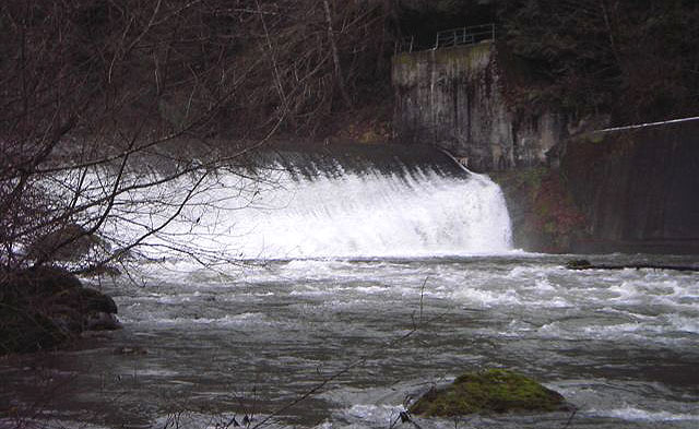
Photo of the dam: Oregon Kayaking Trip Report, 2005
After the diversion dam, you run a few smaller read and run rapids bore reaching the first rapid of distinction. This rapid was a bit tricky; you can see the branch sticking out of river left (pictured below). It was relatively easy to avoid, and like most drops on the run, easy to scout and set safety from below.

First rapid of distinction after diversion dam.

Matt sets safety from below. Here you can see both the sneak line (between the two boulders on the left) and the main line in the middle on the same drop. Both lines work just fine.

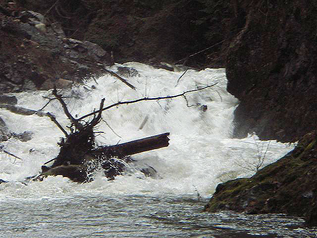
From above, the next rapid looked like another read and run. We all routed through the drop, to find a piece of wood that was in the middle of the rapid. Two paddlers in our group “rail slid” over the wood, others were able to avoid it. Enter with caution, as there is pin potential with the current placement of wood.

Lila punches the final hole in the above described rapid. The wood cannot be seen from this photo beacuse it is slightly covered by water. It is located a short distance above where Lila is pictured, in the middle of the channel.
After this point, there is a little bit of boogie until you reach a big pool, which marks the infamous “Landslide” rapid. A group of paddlers in 2004 were separated by the initial landslide, leaving the group downstream, with little water from the dam created by the landslide, and the group upstream with the option to try to cross the slide, or to hike out. They hiked out.
In 2005, a group from Oregon Kayaking went in and the drop was still not runnable. The rapid has since been anthropogenically altered for fish passage. The resulting rapid is more manageable, and it saw numerous descents during the 2015 release.
Oregon Kayaking’s photo from a later trip in 2006.


Landslide Rapid, 2015. Ben McKenzie taking home all the points for style, and being the first in the group to probe the rapid. Photo: Nick Hymel

My line. Photo: Nick Hymel

While most of us went deep in the seam on the left, Jacob chose a route down the middle that avoided submersion.
Photo: Nick Hymel

Matt King charging the seam. Photo: Nick Hymel

Jesse Shapiro about to test the depths. You can see the pocket on river left in this photo that many of us flushed into, fortunately it was pretty friendly and everyone was able to hold on and roll up. Photo: Nick Hymel
It should be noted that due to the dynamic nature of this river, and the slide area itself, this drop could change every year. We all felt the drop deserved class 5 attention, but was more forgiving than many rapids with that distinction and was definitely one of the most fun drops on the run. There is also an easy portage option across the slide on river right.
After this, there are a few more read and run rapids before you approach the powerhouse. Pick out a line over the low-head diversion dam, and continue on to Last Nasty- the last formidable rapid on the run. This one is aptly named, as it is easy to float into it and assume it is another read and run. The rapid deserves attention as the wrong line could place you in a sieve or get you pinned. Our group floated into this one resulting in one pin, a few surfs and a lucky line that barely missed the main sieve hazard on the left. The entrance to the rapid is marked by a large boulder in the middle of the river. Take the right channel and find an eddy to scout.
You want to catch the eddy on river right to scout the last part of the drop. You can see the sieve pictured river left, we chose to run the final ledge 5-10 feet off the right bank though many lines were taken during the release.
Last Nasty from below, Ross clearing the hole. Photo: Matt King
From this point there is very little until you reach the Trout Farm takeout. Overall I thought this was one of the more unique and enjoyable runs of the year. We had around 900 CFS, and felt that was a healthy medium flow. Overall I thought this run lived up to my expectations and offered fun, clean rapids, unique scenery and a great opportunity to get on a run that is not often accessible.
Access (From American Whitewater):
PUT IN:
Just east of the town of Sultan (Highway 2 mile 23.1) turn north up Sultan Basin Road towards the Sultan Basin Recreation Area. Follow this road 13.5 miles to Olney Pass. The Culmback Dam Road heads down to the left. This road was gated for the past few years but more recently it has been open and the road is a public easement to Forest Service property (in the past Barry Chrisman, the Hydroelectric Plant Supervisor has answered questions regarding gate access and he can be reached at 425-783-8804). Just before you reach the dam an old forest road turns off to the left (FR 6122, aka the Jenny Ring Road). Drive up this road to a large clearing and start walking. The traditional put-in was reached by following this road to the old log bridge a couple miles downstream from the dam (47.9701N, 121.7228W, WGS84). As a condition of the new hydropower license American Whitewater negotiated the development of a new trail into the canyon that was professionally constructed to Forest Service trail standards and completed in 2014. This trail puts you in the river one mile below Culmback Dam. Scrambling down the face of the earthen dam is tempting but illegal and you likely want to get a bit downstream of the dam to find enough inflow from the sides. Snohomish PUD has installed security cameras here and informed us that they will not tolerate trespassing on the dam. The other difficulty with putting in at the base of the dam is there are reports of some class V rapids in this section that may be difficult to scout or portage. Steep canyon walls limit access between the dam and the old bridge site although there are a couple spots where river access is possible.
TAKEOUT:
Most continue on the Sultan below Powerhouse run and use the Sultan fishing access at Trout Farm Road. You can reach it by taking the first street east of the Highway 2 bridge across the Sultan. After turning onto this street in the town of Sultan, take a left headed back towards the river. When you get to First Street follow it north as it parallels the river. As you pass out of town, slightly less than a mile down First Street, Trout Farm Road turns off to the left. Follow this 1.3 miles to a well marked fishing access point on the Sultan River. Park in the gravel parking area near the road and walk down a dirt road to the river. Alternative access points are available at the Powerhouse but gates will likely be locked by the time you get there, requiring you to continue downstream (they may be open on scheduled release days however).
No comments:
Post a Comment