

BETA
2 miles, IV(V) with the option to put in higher for some V-V+
Stream: Cedar Creek used to have a notorious reputation as a fringe run, only for those looking to hairball down some class V+ with tiny eddies. While you can pick off some large drops above the put in, there is also a roadside 2 mile section of nice class IV(V) that is verging on must-do for Willamette Valley boaters.

Photo: Priscilla Macy
While Cedar Creek can be run on it's own, it combines well with a run on Classic Opal since it is easy to use the same take out at Three Pools. From there it's just a short drive upstream to the bridge over the Little North Santiam at the Cedar Creek confluence. Boaters can scope out the wood situation as they drive along Cedar Creek, there are usually a couple logs and some brush that need dodging.
For how roadside it is, there are some beautiful spots on Cedar Creek.

Photo: Priscilla Macy
Hellevator, one of the big ones above the put in on Cedar Creek.

Most people will skip the big stuff and put in at the base of Coombs.

Things start off with a short section of engaging whitewater. After the first few rapids, things ease off for a bit and there is some mellow class II-III with a manageable amount of wood and brush to maneuver around.
One of the first fun rapids.

Things pick back up at Impaler, which comes just after passing a campground with a fence visible from the creek on river left. Downstream the creek enters a straight away with a horizon falling back to the right at the end. The eddy to scout/portage is on the left half way between the horizon and the sign in the photo below.

Impaler is a two ledge rapid, the first is ugly and the second is good so most people choose to seal launch straight into the lip of the second ledge. The second ledge can also be portaged with a seal launch a bit further down.
A few more good class IV rapids separate Impaler from Box Drop, the second and final class V rapid. Box Drop was also marked by a yellow sign in the trees on the left in 2020, just below a fun rapid with some offset hydraulics ending with what qualifies as a pool on Cedar Creek.
Box Drop has been run both right and left, but also has an easy portage on the left.
Ben does it right.
Some more read and run leads into the campground/gauge ledge, which is run center.

Then it's non-descript but steep whitewater all the way to the confluence, on both my runs we have hopped out once to scout down here. Once on the Little North Santiam it's about 1 mile of boogie down to Thor's, which can be scouted along a trail on the right if flows are higher than you typically run Opal.
In 2020 there was plenty of wood and brush to be maneuvered around on Cedar Creek, but no wood portaging.

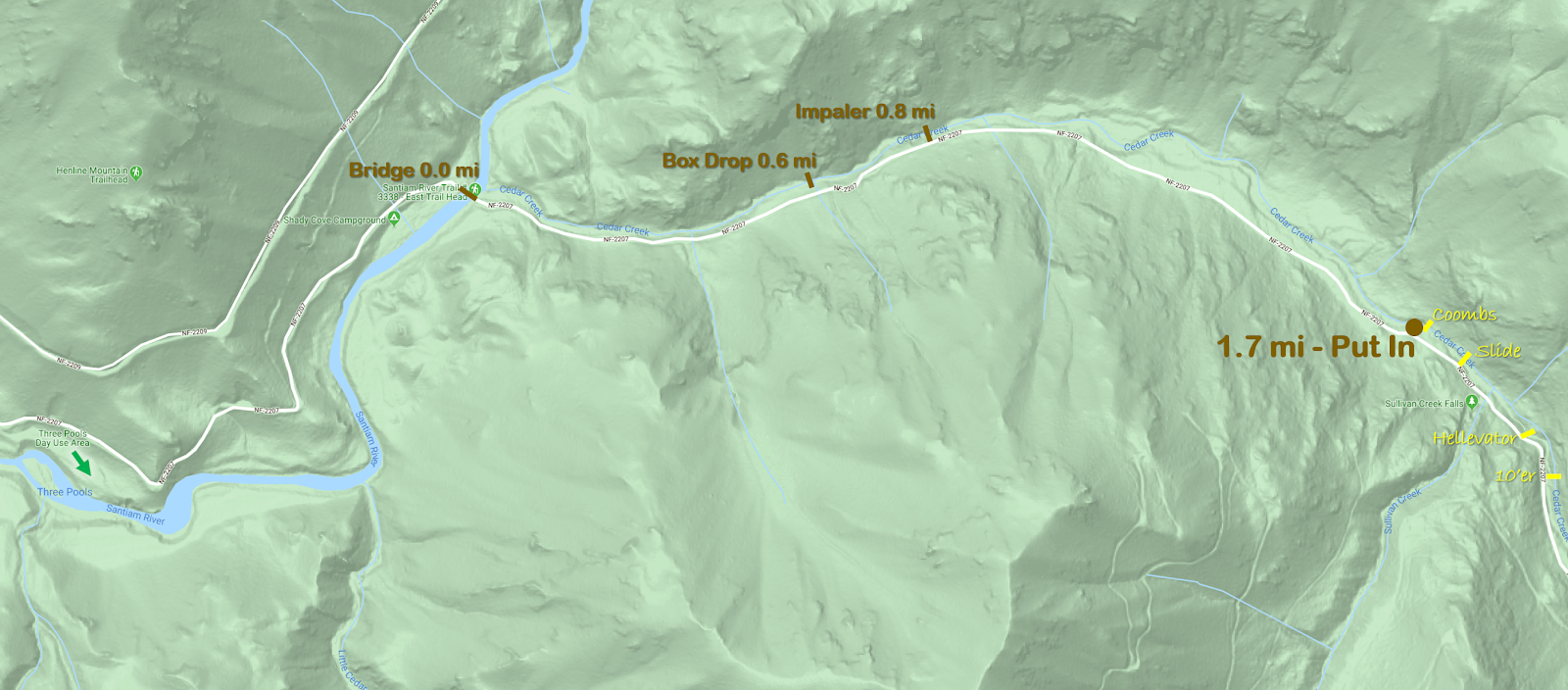
Thorough scouting from the road beforehand makes the trip run smoother, as it's less likely stuff will sneak up on you. While Impaler and Box Drop were signed in 2020, if you want to visually inspect the eddies before putting on you can do so 0.6 and 0.8 miles above the bridge at the LFN/Cedar confluence.
Flows: Use the Little North Santiam @ Mehama gauge to ballpark flows, keeping in mind it can make a big difference if flows are rising vs. falling. We were there two days in a row to start off 2020 and the first day flows were higher than I would run the creek, with big holes and few eddies. The second day flows were what I would call a perfect medium. Graph below.

Once at Cedar Creek, you can get a visual at the campground ledge, about 1/4 mile upstream of the Cedar/LNF Santiam confluence.

There are two rocks on the lip of the ledge that can be used to assess flows. The one circled in blue needs to be covered for the creek to be worth paddling. Perfect flows have just a tiny bit of water spilling up and over the rock circled in orange. If there is enough water that you could potentially paddle over the orange rock, flows are high. I personally would never paddle this creek high, as stopping would be a real challenge due to sparse eddies, it would be a high speed class V descent with wood in play.
Water over blue rock = enough water Orange rock boofable = high water

High

Perfect Medium.

Friendly and fun.

Coming out of the Three Pools parking lot, turn right. In about 1 mile you cross a bridge at the confluence of the Little North Santiam and Cedar Creek. In another 1.7 miles is the small pull out on the left adjacent to Coombs, this is the put in. If you are looking at the creek from the road you should be able to catch a glimpse of Coombs through the trees. If you get to Sullivan Creek, you have gone too far.
If you are interested in the 1/4 mile of V-V+ above the put in, it is all roadside and can be thoroughly scouted. That section starts with steep bouldery rapids leading into a ten footer that need to be run boofing right to avoid a rock in the landing. A hundred yards of more steep boulder garden leads to Hellavator, which is reminiscent of a more challenging Gorilla. More steep boulder gardens lead to a fun slide just below the Sullivan Creek confluence, you can exit the creek just below this slide on the left. Right around the corner from that slide is Coombs, without any real eddies above it.
Click on map to increase resolution.
----------------------------------------------------------------------------------------------------------------------------------------------
The Upper 1/4 mile
----------------------------------------------------------------------------------------------------------------------------------------------
----------------------------------------------------------------------------------------------------------------------------------------------

Cedar Creek has quite the reputation. When the report from Oregonkayaking for the upper section was written, the creek was still being utilized as a hair-boating destination.
Those guys went back and ran the lowest mile a couple years later, which seemed like it would appeal to more boaters, but was pretty short.
After a couple scouts and confirmation from Pete Giordano that it really wasn't all that bad I was set on trying it out at some point.
Last weekend we were floating by on Classic Opal and noted that Cedar looked like it was at a good flow. Once we reached Thor's, it was decided that instead of doing the usual and continuing through Opal Gorge that we would pack up and check out Cedar.
We noticed a log portage a hundred yards above the confluence with a convenient trail up to the road just above so used that as our take out. Continuing upstream we scouted the eddy situation for Box Drop, The Impaler, Coombs, and Hellevator at about .6, 0.8, 1.7 and 1.9 miles above the bridge near the take out respectively. Fortunately all of those spots are visible from the road for those with a sharp eye.
Ben Mckenzie and Brian Ward put in where Oregonkayaking put in, Brian Butcher and I put in at the confluence with Sullivan Creek.
Ben Mckenzie and Brian Ward warm up above Hellevator.
Neither of them were able to hit a boof on the first ten footer, but both were online and avoided hitting the rock that is deep in the center of the landing. They paddled some of the boulder garden downstream before climbing up to the road to get around Hellevator. Hellevator is like a stouter version of Gorilla on the Green River in North Carolina. The walk was easy along the road on the left, and we all put back in just above or below the Sullivan creek confluence.

Just downstream of Sullivan was a fun slide, the best drop on the whole creek. I sent everyone down on verbal before joining in on the fun myself.
Looking into Hellevator along the portage on the road.

Just downstream of Sullivan was a fun slide, the best drop on the whole creek. I sent everyone down on verbal before joining in on the fun myself.
The Slide
Almost immediately downstream was Coombs, Brian Butcher portaged left just below the slide which was the thing to do. The rest of us portaged the ledge on the right, then ferried across to where Priscilla (who was providing ground support along with Sam Box) pulled us onto shore. This is the trickiest eddy situation on the creek, and really we all should have done what Brian Butcher did. Ben looked at Coombs seriously, but in the end decided to join the rest of us in the portage on the left. I feel Coombs looks better at higher flows, but is always on the V+ side of things. Very runnable, but stout.


Below Coombs we entered the normal run, and it was a good time making our way downstream. The run was consistently steep class IV, a few times we had one person hop out and send the rest through on beta.
Priscilla and Sam helped us spot the eddies above Impaler and Box Drop, which was a big help as they sneak up. (2020 they are now signed).

The first tier of Impaler.

Brian Ward finishes up Box Drop.

We skirted one log on the left and took out on the left just above a sign reading "One Lane Bridge".
A good run, one I will certainly be back to.
A good run, one I will certainly be back to.

We had flows peak at 1,200 cfs on the Little North Santiam @ Mehama gauge on (Nov 8, 2015) and thought we had a good level.

Gauge ledge

Just upstream of the confluence with the Little North Santiam the day we ran it.

-jacob
No comments:
Post a Comment