If you enjoy
Canyon Creek Oregon, this is another run in the Willamette Valley that you might be into.
You have two choices when running the creek, put in at the top where there is easy bridge access, or hike in for the bottom couple of miles. Putting up at the top makes this a full day mission, while putting in for the bottom two miles amplifies the bang for your buck and is done more often.
The upper section is full of steep boulder gardens with a sprinkling of wood. These can be scouted and portaged at river level.
Photo: Andrew Morrisey
There is a flat section, before the largest boulder garden on the run. Most everyone will walk this massive cataract created by a landslide. You can stay close to the bank or go high on the right for the portage.
Just below the landslide cataract is the put in for the lower section. While the
upper Section has a bridge at the put in, the lower put in requires about half hour of descent through the woods.
Teamwork on the hike in.
(photo: Nate Merrill)
This lower run starts off as fast paced class IV boulder gardens and ramps up to IV-V. Some clean, some not.
Everything can be run, but some are worth deliberation. Reading and running is possible, but I prefer to shore scout most of the notable boulder gardens in this first part, especially with the likelihood of wood being in play.
Andrew Morrisey runs one Iv'e always walked.

The character continues this way until a busy straight away with a couple large boulders on the left bank ends in a sharp left bend. Just around the bend is the largest boulder garden of the run, so it's prudent to stop early on the left before being committed to the rapid, which has a large midstream sieve part way down. Iv'e seen this one run, but have always made the easy (if you get up on the bench) walk on the left. The portage route drops back to river level just above a fun boof in the middle of the river.
100 yards below here was Rhinosex, which does not look friendly at all. Though it is runnable, the lead in drop is ultra hectic, and being upside down over the second drop has had dire consequences in the past.
The portage is on the left, and either involves a short carry and small rope lower, or little longer of a carry to where the land gradually leads back to the creek.
Below here are a couple of boulder gardens, one of them trashy. Then comes a sharp left bend with an eddy below on the left. The next boulder garden leads into Balls Falls. Be careful here, it is worth scouting out your eddy on river left before entering the sharp left turn.
I scout while Jeff and Andy help people across the deep current over to the viewing platform. At high water this drop is hard to scout thoroughly.
(photo: Nate Merrill)
Balls falls isn't as gleeful as I had anticipated. The transition on the first tier is kind of abrupt and wants to shoot you left. Its still a fun drop, but not the auto-launch pad I had expected from photos.
Nate Merrill running the first tier of Balls Falls.
The lower tiers are the main concern. There is a sticky hole leading immediately into a large ledge with two channels. The left channel is friendlier, but harder to get to, while the right channel is chaotic and has a shelf protruding off the right side. On our first trip, all 7 people ran Balls Falls. 4 of them collided with said submerged shelf, one was backwards and was immediately ejected from their boat. One made the left line, while Nate and I caught the river-high eddy below the first drop and portaged the bottom two tiers.
The first drop was entertaining for me, as I had not made up my mind about the line I would take. Jeff and I were going to catch an eddy on the right to take another look and scout a portage line. The lead in drop pushed Jeff hard left though, and he couldn't make the eddy and the last thing I saw was a flurry of stroked with him sideways. I wasn't sure how he'd done, so I followed and boofed into the eddy on the right in case he needed help, but he came through fine and we were now in good positions to set safety for the rest of the group.
The next drop had a sticky-ish hole at the end we all made it through, but safety would be prudent. One more short class III and we were out scouting Snake Bite. I would suggest scouting initially on the right. Most of us scouted on the left, but this left the last person to portage in a bad spot as it was slick getting into the boats without a spotter and falling meant a trip into the powerful hole at the bottom of the slide.
Three of us decided to run the drop. Myself and Aaron took the left line, which was a fun twisty slide with a critical stroke at the bottom to get through the large hole. Nate Pfiefer ran the right side and hit the seam where the hole flushed at the bottom. Both sides went, you will have to choose which looks better to you.
Below here were two more class five boulder gardens. Jeff and Aaron stepped up to the last challenging drop, while the rest of us portaged on the right. One of the boulder gardens would be easy to swept into if you were boat scouting aggressively. Below the last big boulder garden was a series of slides that would create large, uniform holes at higher levels. We stayed generally right, then back to center for the last one. Below here things cooled down and we had about a mile of runout to the miracle mile.
We splashed through the last hundred yards of bigger water and caught eddies on the left at the bridge. Spent but ecstatic about the great day of boating.
We had 3.65 on
NFMF @westfir. I don't know the area levels as well as some people, but I would go back if this gauge was between 3.5 and 4, though up to 4.5 is still medium. It has been run at over 5.5' by the Dinsdale's, who considered that about as high as they would repeat the run (they prefer more water in rivers than most).
Many boaters haven't switched over to the new online gauge and still use the foot gauge at the take out for the Miracle Mile. On that gauge a foot is the low end. 2.5' on the bridge gauge was reported as difficult but ultimately very enjoyable by the Dinsdale brothers on May 15, 2022. 1.5-2 is what I personally think of as medium.
Thanks to Nate Pfiefer for
doing the legwork that helped put this run back on the radar for Willamette Valley boaters after a hiatus before I first ventured in. I may still not have paddled Christy to this day without his efforts.
The first time I did this run it took much of the day, the second time we moved quick and went car to bridge in 3.5 hours. Plan on scouting a lot your first time down.
Take out (same as Miracle Mile): 43.8799, -122.3854
Lower Put In: 43.9114, -122.367
Upper Put In: 43.9223, -122.312
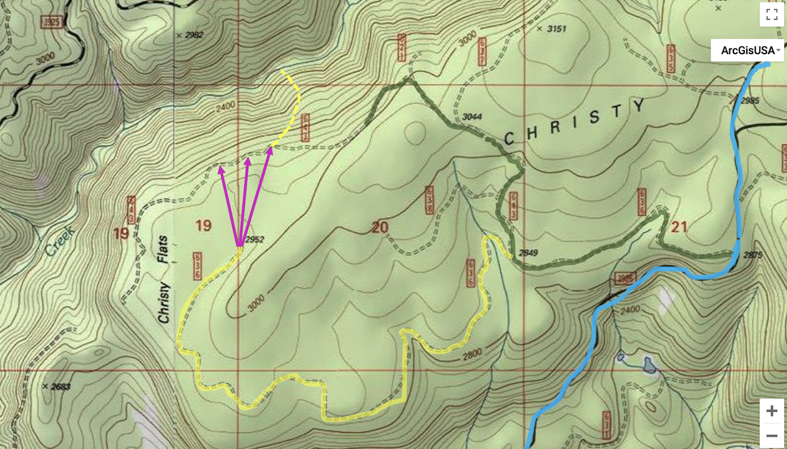
Map with directions to get you where you need to go. However, the NF 637 rd has been decommissioned so extra hiking is needed. The yellow route in the second graphic shows the way I'd go in the future.
Green is the old route, yellow the new. The pink represents off-trail woods hiking to another road, then the yellow dash is the bushwhack down the side of the canyon. A chainsaw is a good thing to have for the shuttle.
-Jacob