Monday, May 9, 2011

Nohorn Creek


BETA


Stream: The run starts off with a nice 10'er at the put in.  From this point until Cookie Monster there is loads of quality class III-IV whitewater in a small and intimate streambed.  Hugh Creek adds some water when it enters from the right and the creek seems to get even better for awhile. 


About 2 miles downstream of Hugh Creek is Cookie Monster, just after a gradual 180 degree turn in the river to the right.  The horizon line is obvious, and while there is a good eddy on the left, it can be partially blocked by wood so stay frosty.   Cookie Monster is easier at low water, at high water a large hole forms. 


Cookie Monster.


 In the next mile below Cookie Monster are a couple ledges that are taller than what has been typical for the creek.  The first is easiest far right.  The second should be scouted from the bridge on the drive up to locate the best landing zone, center-ish.  Downstream it's boogie to the Hot Springs Fork of the Collowash confluence, and then in a 1/4 mile of easy floating you will be able to see the horizon line for the finale at Pegleg Falls.   Pegleg is an off-vertical 15' drop into a forgiving pool with many line choices, a good way to finish a good run.  


This is a high mountain Oregon stream, so keep an eye out for wood.  There are usually some portages, and some wood dodging, but historically the wood has not kept the run from being worth doing.

Since you are so close, instead of gearing down, consider driving downstream less than 1/4 mile to the bridge over Blister Creek.  There is a beautiful 30' park and huck visible just upstream of the bridge.


Flows:  Clackamas at Three Lynx at 5,000 cfs is considered medium.  3,000 is a low, but still worth doing flow.  I haven't heard of anyone taking a trip up there and having too much water yet.

Access:  Take out at Pegleg Falls (44.9572, -122.1619), or continue through the Hot Springs Fork of the Collowash as far as you have time for.  

From Estacada, take Hwy 224 SE up the Clackamas River for 29 miles (passing the Ripplebrook Ranger Station at 24.5 miles).  At the 29 mile mark turn right onto NF-63 where you will quickly cross the Clackamas and less than a mile later the Collowash.  Following the Collowash upstream for 3.5 miles past the turn off Hwy 224, and turn right onto NF-70/Bagby Rd.  In 5.5 miles is Pegleg Falls, which is no longer operational.  However, you can still park at the gate and walk down into what used to be the campground to confirm you are at the right spot by looking upstream (you will see Pegleg).

To get to the put in, continue upstream on the same road 3.9 miles (stay right at 1.8 and 3.5 mi).  Looking down into the creek you should be able to see a log jam, put in below it, which is just above the first ten foot drop (44.9352, -122.2117).


Notes:  You can read about pioneering this creek over at Oregonkayaking.net.


----------------------------------------------------------------------------------------------------------------------------------------------
Trip Report
----------------------------------------------------------------------------------------------------------------------------------------------


We headed up to Nohorn creek yesterday (May 8, 2011).  It was low but still a good time at 3,000 cfs on the Clackamas @ Three Lynx gauge.


 We used the upper put in that Pete Giordano found last year.  The snow situation meant the last mile of the road was not drivable, but also that we could drag our boats.  This upper put in added a small slide and a nice ten foot boof.  Followed by a short log jam portage and some other splashy rapids.  I would choose this upper put in for any trip to Nohorn.


The rest of the run is well documented over at Oregonkayaking.net.

Once Hugh creek come in on the right the creek enters a fun mini gorge section with good quality III-IV rapids.  There are some in-between sections that were a bit dull at this level, but at normal levels these would move right along and the classic Oregon scenery helps pass the time as usual.


 We kept thinking every horizon was Cookie Monster.  But it was pretty obvious when we got there.  We snuck into an eddy at the lip on the left.  Though catching an eddy higher up might be a good idea if there is more water in the stream.

 Nate and Luke point out the issues with the rapid.

The low water meant the big hole that usually dominates the left side of Cookie Monster wasn't in play.  A couple of us ran it, but it had enough going on that most took the portage route on the left.
 The six foot ledge has a log in it now.  Luke went for the rail slide which was pretty sweet, with more water I would suggest running middle or right.


Be sure to take a look at the ledge visible from the bridge on the drive up.  It should be run center, but the shallow lead in makes it difficult to fall into the deep part in the center.  We wanted to take out at Pegleg, so continued on the short distance to this beautiful and forgiving 15' falls.  Lap one we all went for the plug on the left, trying to maximize downtime.  The falls is easy to lap and there are many line choices so there was no reason to pack up in a hurry.

Luke, round 2.

 Luke picks out another route.


Our trip in fast forward.


To get to the upper put in.  Go towards these coordinate points (can copy paste these into google maps).  44.931235489969055,-122.2170639038086

If you are looking at the creek (should be the first good view you get since crossing Hugh Creek) and see a short bedrock slide with a tree spanning the creek right over the slide.  
Put in there, just above the slide to save yourself some mank upstream.

   -Jacob


Sunday, May 8, 2011

Via Jeff Compton

Christy Creek has now been rafted.

It was epic.  I rafted in the puma with josh.  Dan and I fired up Rhinosex.  Josh and I flipped in Balls. 1.75 feet on the gauge.


Tuesday, May 3, 2011

Christy Creek


(photo: Nate Merrill)


If you enjoy Canyon Creek Oregon, this is another run in the Willamette Valley that you might be into. 

You have two choices when running the creek, put in at the top where there is easy bridge access, or hike in for the bottom couple of miles.  Putting up at the top makes this a full day mission, while putting in for the bottom two miles amplifies the bang for your buck and is done more often.


The upper section is full of steep boulder gardens with a sprinkling of wood.  These can be scouted and portaged at river level.  

Photo: Andrew Morrisey

There is a flat section, before the largest boulder garden on the run.  Most everyone will walk this massive cataract created by a landslide.  You can stay close to the bank or go high on the right for the portage.


Just below the landslide cataract is the put in for the lower section.  While the upper Section has a bridge at the put in, the lower put in requires about half hour of descent through the woods.

Teamwork on the hike in.
(photo: Nate Merrill)


This lower run starts off as fast paced class IV boulder gardens and ramps up to IV-V.  Some clean, some not.  


Everything can be run, but some are worth deliberation.  Reading and running is possible, but I prefer to shore scout most of the notable boulder gardens in this first part, especially with the likelihood of wood being in play.  

Andrew Morrisey runs one Iv'e always walked.


The character continues this way until a busy straight away with a couple large boulders on the left bank ends in a sharp left bend.  Just around the bend is the largest boulder garden of the run, so it's prudent to stop early on the left before being committed to the rapid, which has a large midstream sieve part way down.  Iv'e seen this one run, but have always made the easy (if you get up on the bench) walk on the left.   The portage route drops back to river level just above a fun boof in the middle of the river.

100 yards below here was Rhinosex, which does not look friendly at all.  Though it is runnable, the lead in drop is ultra hectic, and being upside down over the second drop has had dire consequences in the past.


The portage is on the left, and either involves a short carry and small rope lower, or little longer of a carry to where the land gradually leads back to the creek.

Below here are a couple of boulder gardens, one of them trashy. Then comes a sharp left bend with an eddy below on the left.  The next boulder garden leads into Balls Falls.  Be careful here, it is worth scouting out your eddy on river left before entering the sharp left turn.

I scout while Jeff and Andy help people across the deep current over to the viewing platform. At high water this drop is hard to scout thoroughly.
(photo: Nate Merrill)


Balls falls isn't as gleeful as I had anticipated.  The transition on the first tier is kind of abrupt and wants to shoot you left. Its still a fun drop, but not the auto-launch pad I had expected from photos. 

Nate Merrill running the first tier of Balls Falls.
 
The lower tiers are the main concern.  There is a sticky hole leading immediately into a large ledge with two channels.  The left channel is friendlier, but harder to get to, while the right channel is chaotic and has a shelf protruding off the right side.  On our first trip, all 7 people ran Balls Falls.  4 of them collided with said submerged shelf, one was backwards and was immediately ejected from their boat.  One made the left line, while Nate and I caught the river-high eddy below the first drop and portaged the bottom two tiers.  


The first drop was entertaining for me, as I had not made up my mind about the line I would take.  Jeff and I were going to catch an eddy on the right to take another look and scout a portage line.  The lead in drop pushed Jeff hard left though, and he couldn't make the eddy and the last thing I saw was a flurry of stroked with him sideways.  I wasn't sure how he'd done, so I followed and boofed into the eddy on the right in case he needed help, but he came through fine and we were now in good positions to set safety for the rest of the group.

The next drop had a sticky-ish hole at the end we all made it through, but safety would be prudent.  One more short class III and we were out scouting Snake Bite.  I would suggest scouting initially on the right.  Most of us scouted on the left, but this left the last person to portage in a bad spot as it was slick getting into the boats without a spotter and falling meant a trip into the powerful hole at the bottom of the slide.

Three of us decided to run the drop.  Myself and Aaron took the left line, which was a fun twisty slide with a critical stroke at the bottom to get through the large hole.  Nate Pfiefer ran the right side and hit the seam where the hole flushed at the bottom.  Both sides went, you will have to choose which looks better to you.


Below here were two more class five boulder gardens.  Jeff and Aaron stepped up to the last challenging drop, while the rest of us portaged on the right.  One of the boulder gardens would be easy to swept into if you were boat scouting aggressively.   Below the last big boulder garden was a series of slides that would create large, uniform holes at higher levels.  We stayed generally right, then back to center for the last one.  Below here things cooled down and we had about a mile of runout to the miracle mile.

We splashed through the last hundred yards of bigger water and caught eddies on the left at the bridge.  Spent but ecstatic about the great day of boating.

We had 3.65 on NFMF @westfir.  I don't know the area levels as well as some people, but I would go back if this gauge was between 3.5 and 4, though up to 4.5 is still medium.  It has been run at over 5.5' by the Dinsdale's, who considered that about as high as they would repeat the run (they prefer more water in rivers than most).

Many boaters haven't switched over to the new online gauge and still use the foot gauge at the take out for the Miracle Mile.  On that gauge a foot is the low end.  2.5' on the bridge gauge was reported as difficult but ultimately very enjoyable by the Dinsdale brothers on May 15, 2022.  1.5-2 is what I personally think of as medium.

Thanks to Nate Pfiefer for doing the legwork that helped put this run back on the radar for Willamette Valley boaters after a hiatus before I first ventured in.  I may still not have paddled Christy to this day without his efforts.

The first time I did this run it took much of the day, the second time we moved quick and went car to bridge in 3.5 hours.  Plan on scouting a lot your first time down.


Take out (same as Miracle Mile): 43.8799, -122.3854
Lower Put In:  43.9114, -122.367
Upper Put In:  43.9223, -122.312

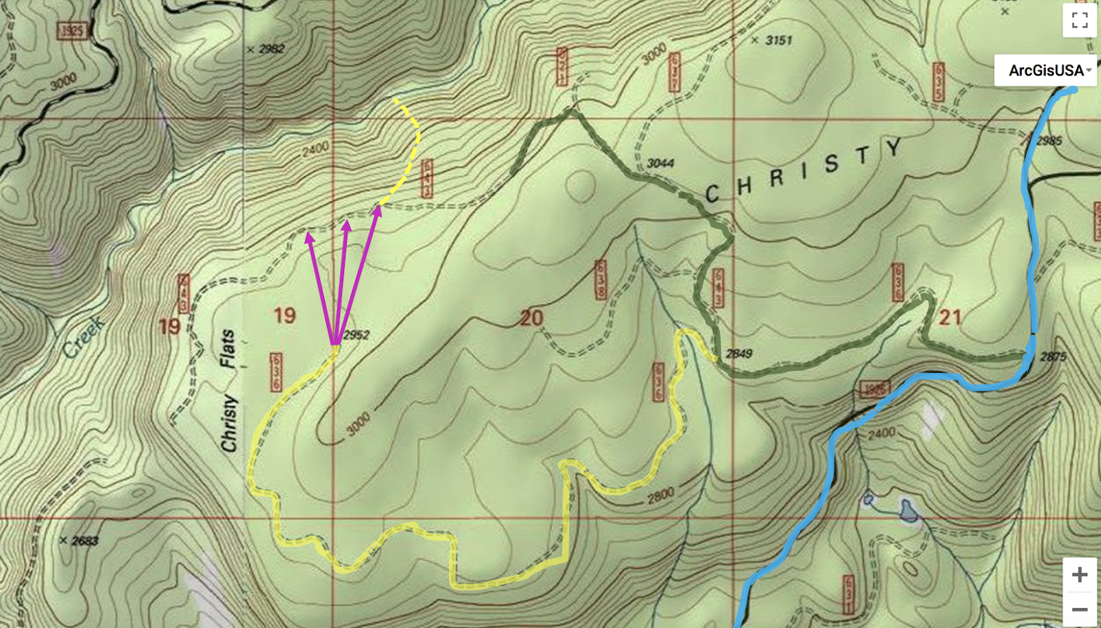
Map with directions to get you where you need to go.  However, the NF 637 rd has been decommissioned so extra hiking is needed.  The yellow route in the second graphic shows the way I'd go in the future.


Green is the old route, yellow the new.  The pink represents off-trail woods hiking to another road, then the yellow dash is the bushwhack down the side of the canyon.  A chainsaw is a good thing to have for the shuttle.


   -Jacob


Monday, April 25, 2011

NWCC

Matt and myself drop Sunset falls simultaneously. 
(photo Nick Gordon)
Once again a big gathering of boaters showed up for the race this year.  With higher than normal levels, the race was moved to a class III section ending with Sunset falls, which dished out more than one swim on this day.

 My friend Paul, after having photographed Dan and Sigler for the last year or so, finally got in a raft and ran his first waterfall, a success! 

Mccain and Thomson
photo: Gena (soon to be) Mccain.


Paul Thomson took a bunch of really good pictures at the creeking competition. I think he got most everybody. You can check them out here. He can be emailed directly at paultnature@yahoo.com onthewildsidephotography.com
-Jacob

Friday, April 22, 2011

Wiki Creek #1

    Coming soon...

Wednesday, April 13, 2011

Little Nestucca


BETA


Stream: The Little Nestucca is a fun roadside run near Pacific City, about an hour west of Salem.  There are three stand out rapids, and the rest of the run is class II with some surf.  It's a great place to perfect and then put your class IV skill set on trial before dipping a toe into low end class V.


Below one of the many bridges over the Little Nestucca, the run begins with about 100 yards of flat water to warm up in.  At the end of the moving flat water the run gets right into it with the busiest section of the whole river.  This first half mile of whitewater is is fast paced and action packed, with loads of crisp boofs and a variety of moves.  If class IV is your limit this section will be challenging and lacks recovery pools, if you are comfortable on class IV this will be a great time.  


There are numerous ledges to boof and only small eddies to re-group in, some of the best boofs are not obvious from above.  It's worth doing a few laps to dial in the fun lines and avoid the manky parts.


 In the middle of this section is one drop that requires some clever maneuvering, at low water bouncing off the rocks is part of the game here, and enjoyment will depend on your ability to control your bow.  There are numerous ways to tackle this rapid, pick your line beforehand from the road.

Priscilla shimmies through the rocks, it becomes easier as levels come up.


The majority of the whitewater can be scouted from the road, so take advantage of that to find the tricky spots, and locate some of the boofs you might otherwise pass by.  This section can also be fast at high water so scouting out some eddies beforehand ain't a bad idea either.


When I was going to college at WOU, I would come up here between classes and do laps on just this half mile bridge to bridge section that starts off the run.  There was plenty of action and a short shuttle made laps easy. 

There is one last fun boof/hole just above the bridge at the end of this first section that I like in particular.

It's easy to jog, bike, or switch shuttle drivers to get a few laps up here.  The more laps you do, the more fun it becomes.

 A bridge marks the end of this first section of whitewater as the stream eases into class II downstream, keep your eye out for places to practice eddy catching, ferrying and surfing below the bridge.  

This spot in particular was nice with three eddy-serviced hydraulics in a row.

Most of the river between the rapids looks like this.


Another bridge, followed in less than 1/2 mile by a small creek that enters from the left marks the proximity of Stella Falls, the largest rapid of the run.  This one can be easily scouted on the left bank downstream of the creek, or from the road during the shuttle.  It's a chaotic rapid, but flushes into a long pool without significant hazard.


                                                                                Stella Falls (2')


More easy floating leads to a class II section with bedrock, downstream it's important to pay attention.  The river gets next to the road again, and another creek will enter from the left.  The river is then diverted to the right by the next small outcrop of bedrock on the left.  The eddy to scout Upton Falls, the most serious drop of the run, is immediately downstream on the right, just above a fish ladder.  It is not inconceivable that a boater would miss this eddy if they were not looking for it.  If water levels are high, it might just be best to take out where the creek enters from the left well above the bedrock outcrop.

We interact with more non-kayakers while paddling this river than is typical for us, most very friendly, one decidedly not.  Below is one of the nice ones.


Upton Falls is a short anthropologically-altered ledge that has a powerful hole, backed up by another man-made ledge under the surface.  It is a straight forward move to boof past the hydraulic on the right at most flows, but the hole is backed up by a ledge under the water, so it is not likely a swimmer would get flushed deep and out.  Good safety can be set from either bank, but that's not to say a rescue would be easy or even very possible.  It's an easy portage on the right.  

                                                                              Upton Falls.


Just downstream is a class II chute visible in the following photo.  The take out trail is across from the large river-right wall, at the top of a small gravelly island on the left. 


Flows:  The gauge is on the downstream, river-right pylon of the bridge at the bottom of the first half mile section of whitewater.  2' is a good medium flow.  You can do the run down to the bottom of the gauge, but it will feel low.  You can even run the three main rapids a touch below the gauge as they channelize well if you are already there kind of thing.


1.25'
Nov 26, 2020, with about 1250 on the Nestucca gauge.
Many of the photos in this report were taken on this day.  The first lap on the upper rapid felt manky, by the third lap we had it figured out and it was flowy and fun.  Stella and Upton were at a good flow.  The in between was blah, and our favorite surf spot was too low.  I'd do it again at this flow, but wouldn't recommend driving far for it at this level.


This level was too low (we did not put on), 675 on the Nestucca online gauge March 4, 2019.


To guess what the foot gauge will be at, I use the Nestucca near Beaver gauge.  On that gauge a flow of 2,000 cfs correlates to about 2' on the gauge, and 1,000 cfs correlates to somewhere in the vicinity of 1' on the foot gauge. 5,000 cfs is too much for most boaters and I don't know what that is on the gauge.

Access:  There are a lot of ways to get there.  The river is roadside along Hwy 130 between Dolph and Pacific City.  

The take out (45.135902, -123.896382) is 3 miles upstream from Hwy 101, there is a mile marker on a corner here.  It's worth scrambling down the fisherman's trail to note what the take out looks like from river level while setting shuttle.

The take out.


The put in (45.110860, -123.852739) is at a bridge 3 miles upstream of that, or 4.2 miles downstream of the turn at Dolph.  The gauge, is the bridge 3/4 mile downstream of the put in, at the bottom of the first, long, rapid.

From Salem Highway 22 will get you to Dolph, but there is at least one non-intuitive turn so use your phone or a map.


----------------------------------------------------------------------------------------------------------------------------------------------
Original Write-up
----------------------------------------------------------------------------------------------------------------------------------------------


A friend of mine from the Earth Science program here at Western has been wanting me to take them out kayaking for awhile.  The first day I took her on an easy run and she seemed to do well and wanted to run something a bit harder.  I had wanted to get some pictures of the Little Nestucca, so decided I could take her there and have her walk the 3 main rapids.

The first section is my favorite part, its about 1/2 mile of quality route finding.

 I had done about 5-6 laps on it so far at higher water each time and like it more each time.

The entrance to the first bit.

 It keeps going solid for awhile once you are amongst it.


The trickiest part of the first section from the road.


There is some easy floating below this first bridge (great rapids for my friend to learn on) until the next main drop, Stella Falls.  This is a cool rapid.  Its short but kinda rowdy for what it is.  The bottom ledge doesn't look to have a dry line so I anticipated a plug.  I was surprised that it was possible to run with a dry head.
 Stella Falls


Same drop at 5500 cfs


More easy floating leads to the last drop, Upton Falls(~6').  This has been altered and is now a lowhead dam.  I suggest scouting/portaging from the right bank, and setting safety from either or both sides.  The hole is backed up and might not let a swimmer go.  The boof on the right was straight forward though, so paddlers confident in their boof stroke should have no issues.

It is worth noting that it would be possible to get swept into this drop unaware.  Once below Stella, there is a "fakey" gorge with some class two, once the stream leaves this section, the next bedrock you encounter is the formation creating the drop.  Immediately eddy out on the right to scout.  Cautious and knowledgeable (about the run) boaters should have no troubles here.

We finished up the run and I was impressed that Aqua made it down with no swims (a couple of T-rescues) and she seemed to enjoy it.


The take out used to be across from this cool old barn, just upstream of Fall Creek Bridge.
**No longer a legal take out option, see access section for legal take out**


This run is out of the way for most people, but if you are thinking about breaking past the class IV mark, this is probably a good stepping stone.  That first continuous section offers a lot of opportunity to perfect boat control, catching small eddies, moving back and forth in fast water, hitting boofs, crossing currents, etc. Stella is as hard/harder than every drop until Big Brother on the Green Truss, but lacks the consequences of class V.  Then there is Uptown Falls at the end, it isn't a good drop to work on your boof stroke, but if you are 100% confident you can hit the line, it's a good place to work on your mental game.  Just don't miss.

 If you are a Corvallis/ salem boater, that first quarter mile is easy to lap and fun enough to be worth the drive.  Its a novelty run, but all roadside and worth seeing.

flows -----  http://www.wkcc.org/levels/?f=cv
minimum   1500
max  4,000
I have yet to see it much over 2000, but it could hold a lot more water.  I actually think the first part and Stella would get easier, who knows...

The put in is at the bridge 3.3 miles downstream of the turn off from Dolph crossing and hwy 22. There is a hundred yards of flat water to warm up in before the whitewater begins.

This is about a three mile section, so about a rapid per mile, so its not a run for a constant bombardment of fun, more of a training ground with time to think between drops.


~1,000 cfs


Same spot at about 5,500 cfs (not recommended at that flow without previous knowledge of the run).


    -Jacob

Sunday, April 3, 2011

Warnicke

I had my usual difficulties getting people to come on this exploratory trip, luckily Stephen Cameron caught a whim and joined.

This stream is part of two forks that join the headwaters of the NF Siletz.  When I came to school 3 years ago this was the first stream that caught my attention because of an obvious waterfall on the topo maps.  After learning the nature of access in the coast range I new this one would be a challenging stream to check out.

Last weekend, I passed on a trip to California and instead scouted out the headwaters of the NF Siletz.  I knew Boulder creek was up here and I wanted to check that out, plus I wanted to check out the access situation on Warnicke, while at the same time getting a look at the Valley of the Giants fork of the NF Siletz and take a hike through some of the few true old growth stands remaining in Oregon's coast range.

My scouting trip was a larger success than I had expected.  Gates were open, roads went farther than I expected, it looked like this stream could be done without excess effort.  Another thing I noticed was the geology was promising.  Trip reports of the NF Siletz left me with the impression it would not be worth the effort, but the guidebook run actually looked good too.

The highlights of this trip were hiking through the Valley of the Giants, which is where I saw Warnicke for the first time, as well as some very large trees.  Second was discovering the road up Warnicke had an open gate.  I started driving up this road and made it about a mile in the course of half an hour.  There were a ton of limbs and rocks to move off the sloppy road and my Civic has little clearance.  I eventually turned back, satisfied that the road went far enough to make a trip worthwhile.

Levels lined up perfectly the next weekend, so after Stephen arrived in Monmouth, we made the long drive into the coast range.  We decided to only bring one car and jog shuttle, which turned out to be the right call.  We made it two miles before the road bermed out, leaving us with a 2 mile hike to the put in.

The hike was pretty tame.  We hiked along an old, slightly grown over logging road with a couple easy-to-nagotiate washouts.  Dragging was possible, though we stuck to our backpacks. Eventually we decided to just shwack down to the creek instead of going all the way to the bridge which turned out to be an interesting call.  We ended up putting in just below a large class five rapid and upstream?  Slides as far as the eye could see.  Since neither of us were very interested in the drop it was a mixed blessing putting in where we did.  We missed out on what looked to be fun slides between us and the bridge, but we didn't have to portage this drop.

*to those that like this sort of drop, it is completely runnable, no wood or sieves and not too scary, just very class V.  Had our favorite probe unit not just moved to Eastern Oregon I'm sure it would have been run.  It can be scouted from the right very easily, but hardly at all from the left where we were.

  Andrew Bradley and I returned and ran this drop in 2012.  Its totally good to go and fun.


In 2012 the CCC went in and got a few more descents of the Golden Goose.  Unfortunately one of these resulted in a dislocated shoulder.

  Lucas Glick with a good line.
Nick Chambers photo


Stephen and I liked what we were seeing geology and water level wise as we floated into the class III stuff below Golden Goose.

Just around the next corner started a mile of quality boating.  Class IV boulder gardens with hardly any wood and really fun.  Steep and continuous. There were lots of 3-4 foot boofs and fun moves.  Every horizon we were waiting for another waterfall, but one never did materialize.  We probably only scouted twice in this section as Stephen brought his slalom skill set to the run and made it so we hardly had to get out at all.  If Stephen had not been on the trip, I would likely have been scouting more.

After the end of this mile was a log portage.  The next mile was III-IV with another log portage, and the last mile was III+ with another portage.  All portages were easy.  Stephen did have one interesting portage by seal launching five feet off a log midstream that went well.

Stephen did almost have to drop into a rapid blind when he ran out of eddies, but was able to catch some slack water along the left wall and saw that the drop went, it turned out not be a big issue, but was exciting for a moment.  This is the drop he runs the bottom part of in the video (He eddied out part way down to let me get a shot as I had already jumped out of my boat when I saw things weren't going to plan).

Speaking of video, this was the only shot I got because we were cruising pretty quickly down the run.

The creek was fun all the way to the confluence with Valley of the Giants fork.  The final drop was an island and as Stephen said about his run "I just ran an unrunnable drop, got stopped by that hole, then ducked a log".  If someone else does this, don't worry, its not as bad as it sounds ;)

From here we had a mile and a half of high quality class III down to the confluence with Boulder Creek, where we took out.  We then "jogged the shuttle", and headed home happy about our accomplishments.

--------------------------------------------
NOTES

-Stephen mentioned how un-epic this trip was.  If there was vehicle access to the top, there would be no reason not to run this thing often when the chance arose.

-I know there are not a lot of paddlers out there who like this type of run, but there are some, and if you want to see a new run that is pretty fun without much work involved, check this run out when the Siletz gauge is over 4,000 cfs.

-This area is the rainiest place in the lower 48 that has a gauge (google Laurel Mtn.).  I have been tricked by nice weather in the Willamette Valley more than once and dressed accordingly only to show up to rain in this area of the coast range only 30 miles to the west.

-You also drive through Valsetz if coming from Portland, which was once the rainiest city in the lower 48. (it is no longer a town)

-Jacob