This run has descended into obscurity in the recent past. It has a promising write up in the guidebook and flows when other Oregon streams are low. It could be that this lack of interest stems from the legal issues surrounding the kayakers who were arrested in 1991 for scouting a rapid on private property back when this stream used to be run on the regular. We checked out the stream this year and had a good day. The guidebook captures the stream pretty well, Iv'e typed that below. You can buy a copy of that book here.
The Nestucca River, classified as a State Scenic Waterway, drops relentlessly through a lush scenic forest into a small valley into which a few small farms are squeezed. Some stretches are quite uniform in gradient, others are pool drop. Much of the river can be seen from the road.
On this run, the river flows through about half national forest lands and about half private lands. The rights of property owners along the river became a major issue in 1991 when kayakers were arrested for trespassing while scouting the class V rapids. The issue is not yet resolved. Do not us private lands to scout or portage around the rapids.
At the put-in at Rocky Bend Campground, the gradient is nearly uniform. Shortly downstream is a class IV rapid. At 1.5 miles below Rocky Bend, after a curve to the right, is Silver Falls, where the river drops over and through a jumble of boulder (class V). At high water a class IV sneak is on the left. Immediately following is a class IV rapids in which the river flows around some boulders and over a shelf. A fast rock garden then leads to a log bridge that is an alternate put in. Enjoyable class II and III water continues for the remaining 6 miles to the take out on river right.
~Soggy Sneakers
Our take:
We found the guidebook description spot on. The stream is indeed a State Scenic Waterway, flowing though a forest. As stated there are a few quaint farms in the valley. We put in higher up than the guidebook run to get some extra miles. We were worried that what we could see of the stream from the road was mostly dull looking, I don't think any of the rapids are visible from the road and the sections viewable from the road passed by quickly. Though no doubt, there is a lot of flat water. There were a few sections that diverged from the norm, including a mini gorge section up top which had some class IV. If a paddler feels comfortable on Jordan Creek, they should be able to handle this run. A middle section offered some anthropogenic fish habitat that could be paddled over. Take a look if you are unsure what the best route through and over these are.
There is a campsite part way through the run accessible from the river if facilities are needed. There were a couple tributaries with fun slides in the 10 foot range on the upper section that can be walked up and ran.
Silver Falls was the rapid on our minds all day, resulting from our unsureness of the runnablility/scouting/portaging situation we would be faced with. As it turns out we were able to scout it from well below the high water line, avoiding confrontation with land owners. We took a left line and thought the section surrounding Silver Falls above and below had whorthwhile rapids. We had 1000 cfs on the gauge, and we were able to scout all the rapids from river level. This is as low as I would recommend running this section. I don't recall any portages, though there were probably one or two for wood. More water would be better.
Edit of the Nestucca River by Anna Herring and Priscilla Macy.
A lot of the tributaries and features in the area had bible themed monikers. We were throwing around a lot of "Church" and "Jah" jokes that day.
Bible Study from Jacob Cruser on Vimeo.
1,000 cfs on the Nestucca gauge provided minimal enjoyable flows.
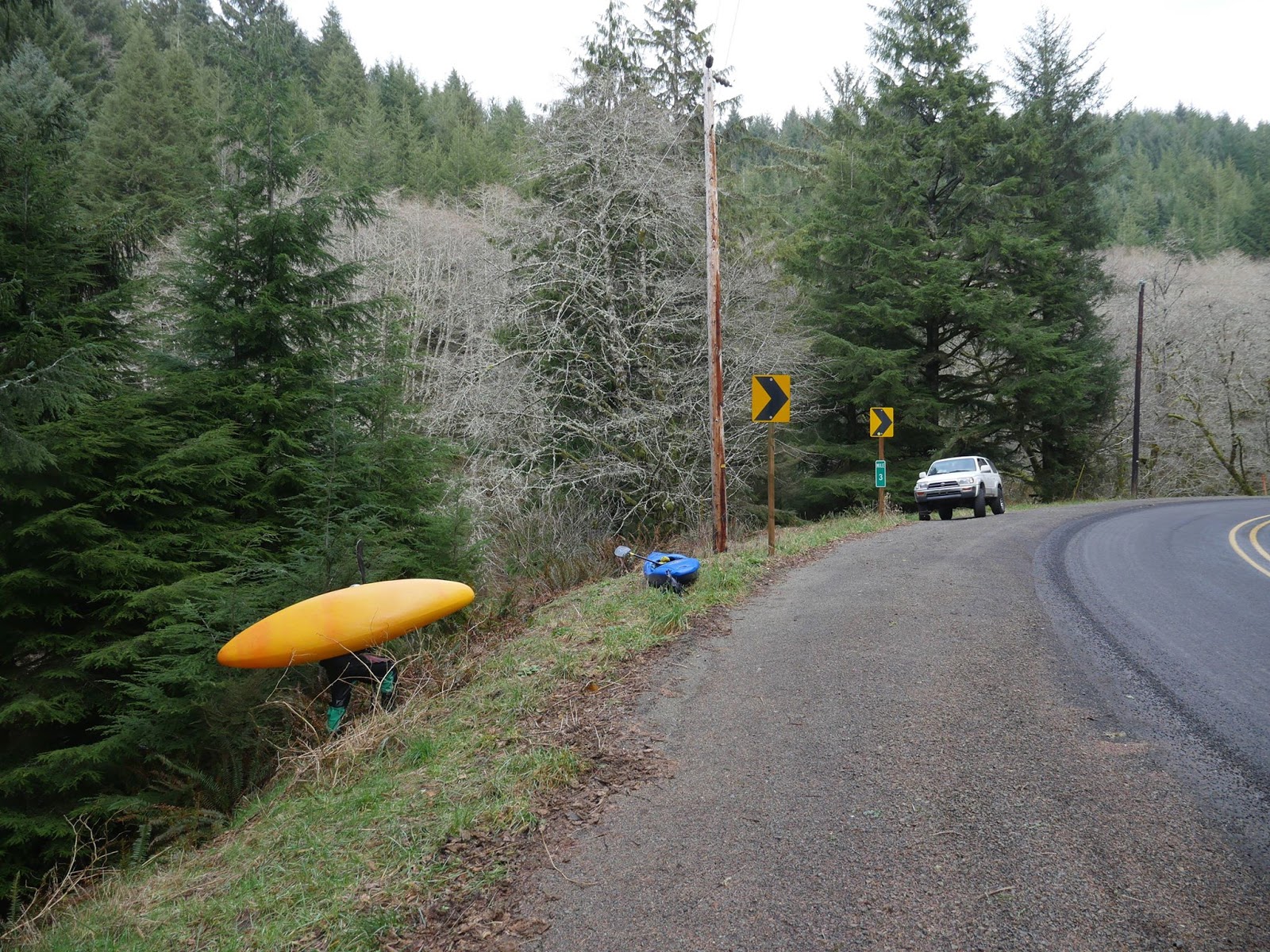
Take out: 45.2788, -123.7071
Put in: I don't actually remember, but the fun mini gorges were above the put in used in Soggy Sneakers.

Showing posts with label nestucca. Show all posts
Showing posts with label nestucca. Show all posts
Tuesday, April 1, 2014
Wednesday, April 13, 2011
Little Nestucca

BETA
Stream: The Little Nestucca is a fun roadside run near Pacific City, about an hour west of Salem. There are three stand out rapids, and the rest of the run is class II with some surf. It's a great place to perfect and then put your class IV skill set on trial before dipping a toe into low end class V.

Below one of the many bridges over the Little Nestucca, the run begins with about 100 yards of flat water to warm up in. At the end of the moving flat water the run gets right into it with the busiest section of the whole river. This first half mile of whitewater is is fast paced and action packed, with loads of crisp boofs and a variety of moves. If class IV is your limit this section will be challenging and lacks recovery pools, if you are comfortable on class IV this will be a great time.

There are numerous ledges to boof and only small eddies to re-group in, some of the best boofs are not obvious from above. It's worth doing a few laps to dial in the fun lines and avoid the manky parts.

In the middle of this section is one drop that requires some clever maneuvering, at low water bouncing off the rocks is part of the game here, and enjoyment will depend on your ability to control your bow. There are numerous ways to tackle this rapid, pick your line beforehand from the road.

Priscilla shimmies through the rocks, it becomes easier as levels come up.

The majority of the whitewater can be scouted from the road, so take advantage of that to find the tricky spots, and locate some of the boofs you might otherwise pass by. This section can also be fast at high water so scouting out some eddies beforehand ain't a bad idea either.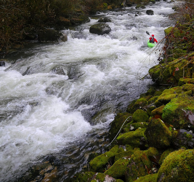
When I was going to college at WOU, I would come up here between classes and do laps on just this half mile bridge to bridge section that starts off the run. There was plenty of action and a short shuttle made laps easy.

When I was going to college at WOU, I would come up here between classes and do laps on just this half mile bridge to bridge section that starts off the run. There was plenty of action and a short shuttle made laps easy.

There is one last fun boof/hole just above the bridge at the end of this first section that I like in particular.

It's easy to jog, bike, or switch shuttle drivers to get a few laps up here. The more laps you do, the more fun it becomes.
A bridge marks the end of this first section of whitewater as the stream eases into class II downstream, keep your eye out for places to practice eddy catching, ferrying and surfing below the bridge.

This spot in particular was nice with three eddy-serviced hydraulics in a row.

Most of the river between the rapids looks like this.

Another bridge, followed in less than 1/2 mile by a small creek that enters from the left marks the proximity of Stella Falls, the largest rapid of the run. This one can be easily scouted on the left bank downstream of the creek, or from the road during the shuttle. It's a chaotic rapid, but flushes into a long pool without significant hazard.
Stella Falls (2')

More easy floating leads to a class II section with bedrock, downstream it's important to pay attention. The river gets next to the road again, and another creek will enter from the left. The river is then diverted to the right by the next small outcrop of bedrock on the left. The eddy to scout Upton Falls, the most serious drop of the run, is immediately downstream on the right, just above a fish ladder. It is not inconceivable that a boater would miss this eddy if they were not looking for it. If water levels are high, it might just be best to take out where the creek enters from the left well above the bedrock outcrop.
We interact with more non-kayakers while paddling this river than is typical for us, most very friendly, one decidedly not. Below is one of the nice ones.

Upton Falls is a short anthropologically-altered ledge that has a powerful hole, backed up by another man-made ledge under the surface. It is a straight forward move to boof past the hydraulic on the right at most flows, but the hole is backed up by a ledge under the water, so it is not likely a swimmer would get flushed deep and out. Good safety can be set from either bank, but that's not to say a rescue would be easy or even very possible. It's an easy portage on the right.
Upton Falls.

Just downstream is a class II chute visible in the following photo. The take out trail is across from the large river-right wall, at the top of a small gravelly island on the left.

Flows: The gauge is on the downstream, river-right pylon of the bridge at the bottom of the first half mile section of whitewater. 2' is a good medium flow. You can do the run down to the bottom of the gauge, but it will feel low. You can even run the three main rapids a touch below the gauge as they channelize well if you are already there kind of thing.
1.25'
Nov 26, 2020, with about 1250 on the Nestucca gauge.
Many of the photos in this report were taken on this day. The first lap on the upper rapid felt manky, by the third lap we had it figured out and it was flowy and fun. Stella and Upton were at a good flow. The in between was blah, and our favorite surf spot was too low. I'd do it again at this flow, but wouldn't recommend driving far for it at this level.

This level was too low (we did not put on), 675 on the Nestucca online gauge March 4, 2019.


To guess what the foot gauge will be at, I use the Nestucca near Beaver gauge. On that gauge a flow of 2,000 cfs correlates to about 2' on the gauge, and 1,000 cfs correlates to somewhere in the vicinity of 1' on the foot gauge. 5,000 cfs is too much for most boaters and I don't know what that is on the gauge.
Access: There are a lot of ways to get there. The river is roadside along Hwy 130 between Dolph and Pacific City.
The take out (45.135902, -123.896382) is 3 miles upstream from Hwy 101, there is a mile marker on a corner here. It's worth scrambling down the fisherman's trail to note what the take out looks like from river level while setting shuttle.
The take out.
The put in (45.110860, -123.852739) is at a bridge 3 miles upstream of that, or 4.2 miles downstream of the turn at Dolph. The gauge, is the bridge 3/4 mile downstream of the put in, at the bottom of the first, long, rapid.
From Salem Highway 22 will get you to Dolph, but there is at least one non-intuitive turn so use your phone or a map.
----------------------------------------------------------------------------------------------------------------------------------------------
Original Write-up
----------------------------------------------------------------------------------------------------------------------------------------------
----------------------------------------------------------------------------------------------------------------------------------------------
A friend of mine from the Earth Science program here at Western has been wanting me to take them out kayaking for awhile. The first day I took her on an easy run and she seemed to do well and wanted to run something a bit harder. I had wanted to get some pictures of the Little Nestucca, so decided I could take her there and have her walk the 3 main rapids.
The first section is my favorite part, its about 1/2 mile of quality route finding.

I had done about 5-6 laps on it so far at higher water each time and like it more each time.
The entrance to the first bit.

It keeps going solid for awhile once you are amongst it.

The trickiest part of the first section from the road.

There is some easy floating below this first bridge (great rapids for my friend to learn on) until the next main drop, Stella Falls. This is a cool rapid. Its short but kinda rowdy for what it is. The bottom ledge doesn't look to have a dry line so I anticipated a plug. I was surprised that it was possible to run with a dry head.
Stella Falls

Same drop at 5500 cfs

More easy floating leads to the last drop, Upton Falls(~6'). This has been altered and is now a lowhead dam. I suggest scouting/portaging from the right bank, and setting safety from either or both sides. The hole is backed up and might not let a swimmer go. The boof on the right was straight forward though, so paddlers confident in their boof stroke should have no issues.
It is worth noting that it would be possible to get swept into this drop unaware. Once below Stella, there is a "fakey" gorge with some class two, once the stream leaves this section, the next bedrock you encounter is the formation creating the drop. Immediately eddy out on the right to scout. Cautious and knowledgeable (about the run) boaters should have no troubles here.
We finished up the run and I was impressed that Aqua made it down with no swims (a couple of T-rescues) and she seemed to enjoy it.
The take out used to be across from this cool old barn, just upstream of Fall Creek Bridge.
**No longer a legal take out option, see access section for legal take out**

This run is out of the way for most people, but if you are thinking about breaking past the class IV mark, this is probably a good stepping stone. That first continuous section offers a lot of opportunity to perfect boat control, catching small eddies, moving back and forth in fast water, hitting boofs, crossing currents, etc. Stella is as hard/harder than every drop until Big Brother on the Green Truss, but lacks the consequences of class V. Then there is Uptown Falls at the end, it isn't a good drop to work on your boof stroke, but if you are 100% confident you can hit the line, it's a good place to work on your mental game. Just don't miss.
If you are a Corvallis/ salem boater, that first quarter mile is easy to lap and fun enough to be worth the drive. Its a novelty run, but all roadside and worth seeing.
flows ----- http://www.wkcc.org/levels/?f=cv
minimum 1500
max 4,000
I have yet to see it much over 2000, but it could hold a lot more water. I actually think the first part and Stella would get easier, who knows...
The put in is at the bridge 3.3 miles downstream of the turn off from Dolph crossing and hwy 22. There is a hundred yards of flat water to warm up in before the whitewater begins.
This is about a three mile section, so about a rapid per mile, so its not a run for a constant bombardment of fun, more of a training ground with time to think between drops.
~1,000 cfs


-Jacob
Subscribe to:
Posts (Atom)