
AFTER ALL THE TRIPS I DID ON THIS CREEK THE ACCESS HAS CHANGED. BOATERS MUST NOW PURCHASE THE BLACK ROCK ACCESS PERMIT FROM WEYERHAEUSER TO RUN THE CREEK. LAST I CHECKED A VEHICLE PERMIT WAS ABOUT $350, AND A WALK IN PERMIT WAS $75. ANY REFERENCES TO FREE ACCESS ON THIS PAGE ARE NO LONGER CORRECT.

Photo: Adam Edwards
Gladiator Creek is my favorite run in Oregon's Coast Range. It's been on ongoing project for me since my first year at Western Oregon University in 2008. This was one of a group of three creeks in the Valsetz area of the Coast Range that laid the foundation for what boating means to me, through the challenges they presented both on and off the water. Iv'e written about the different sections of Gladiator Creek a few times on this site, but this is the page that puts them all together. Access is both straight forward and tricky, linked below is a story from the superstars of Oregon exploratory kayaking detailing the challenges they faced paddling the lower section for the first time in the early 2000's
**ownership has since changed and there is no longer a legal barrier to running this creek.**


After many scouting trips, failures, and a few successes on the lower few miles of Gladiator creek, the biggest piece of the puzzle was placed when Ben Mckenzie, Emile Elliott and I paddled the middle section in 2015. We got lucky with flows and had a great time, with the highlight being perfect levels for the first descents of the ultra clean Vesuvius Falls. Then in October 2019, a decade after first seeing this creek on a map, Ben Mckenzie, Adam Edwards, Joseph Hatcher and I ran all three sections top to bottom over a two day period with Priscilla running shuttle for us. After years of work, and many weekends agonizing over levels and access it had finally been put together top to bottom in one push. With the information gained on these trips, I now feel comfortable going to Gladiator any given weekend the conditions line up, with the logistics as locked in as I could ask for.
And while it's not a run for anybody, now that access is sorted out and no legal barriers are present, despite the effort required everybody who has done it has been glad they did and have been up for returning.

Photo: Dax Kirkwood
Looking back on the influence this creek has had on my thoughts and decisions over the years, I don't think any other stream has defined kayaking for me more than Gladiator has. Each time I paddle the creek, I leave thinking there is not another stream in
Oregon I feel more entwined with than this one.

Photo: Priscilla Macy
Below are links to descriptions for what you can find on each of the three sections of this creek.

This is the most adventurous section, and if you want to give the big drops a real look, plan on doing this section over two days.
MIDDLE (3 miles)
IV-V
 This section is a contender for the best day of creek-boating you can get in Oregon.
IV-V


While there are only 3 notable rapids, they are 3 of the more unique and enjoyable rapids in the state.
Lastly, the part I paddle most often, with the most bang for your buck.
IV-IV+


This run begins part way through the Middle section (below Vesuvius
Falls) and gives a good option for those not interested in Vesuvius Falls.
This is the section I'll do any given day, there is plenty of class fun
whitewater without the commitment of what is found upstream. It starts 1.5 miles above the Lower put in bridge.
FLOWS: The
gauge is located at the only place the creek runs along the highway, the creek is visible here through the vegetation if you are looking for it. This proximity occurs just as you are entering a small town if coming from the east. There is a guard-rail there, and if you park on the west side
of the guard rail (across from the liquor store) you can walk back to
the east 75 feet to where some yellow paint is splashed on one of the posts supporting the guard-rail, marking the point along the guard-rail closest to the gauge. The gauge is just a few wooden shims with numbers on them, glued onto a rock. It's behind a couple trees adjacent to that yellow paint and about 20 yards upstream of the small riverwide ledge/hole/wave
(depending on flow) visible in the photo below.
The visual gauge on Gladiator Creek, and what you might be able to expect based on an approximate correlation to the flow in the Salmon River below Slick Rock Creek Gauge.

Data points

There is more information on each of the section pages about how flows pertain specifically to that section. There is also more detail and the opportunity to nerd out on this other page where I keep notes on historic flows and jot further notes on levels.

I have stuck with the moniker given to the creek by Oregonkayaking.net, who were paddling the creek under the radar on the first descent of the lower section. While the access situation is improving, and currently there is no red-tape or legal barriers to hiking in and paddling the creek, leaving the name off the internet seems like a good way to keep that status quo. Along that same vein Iv'e always tried to keep a low profile when hiking into and paddling the creek, but smiling at anyone working back there and think that mentality will go a long way towards keeping access from being barred to future paddlers. I have left enough information about how to access the different sections on their individual pages (linked above) and this one that someone who has the wherewithal necessary to paddle a creek like this will be able to sort it out just fine. If after all that you think you have the logistics sorted, but end up failing at your attempt and leave this Rock un-turned, you could always give your luck another try at the nearby casino.

Photo Emile Elliott
While there was a time that driving to the put in was allowed on weekends during hunting season, public vehicle access has since been barred. This has come at the gain of the public being allowed to hike into the creek on nice gravel roads any day when the fire danger is not high, though I try to stick to the weekends to keep from getting in the way of daily operations or getting skunked if they are blocking the road. I personally prefer the new situation to the old, given how uncommon it was for this creek to run at a good flow on a weekend during hunting season. While the hiking is straight forward, the distance is not short (3-6 miles depending on the access point and section). I typically use these, but a variety of carrying systems have been deployed, even the old shoulder.
Does smiling with a kayak strapped to your back count as a lie?

Photo: Dax Kirkwood
RULES
There are some rules to be followed if you plan to kayak this creek.
Follow this link to zoom in on the map and bullet points(zoomed to in second graphic). The areas inside the green on the map are open to walk in access. As of 2020 the Gladiator Creek watershed is entirely within the green area. You can double check the kiosk near the bottom gate before starting your hike for updates.


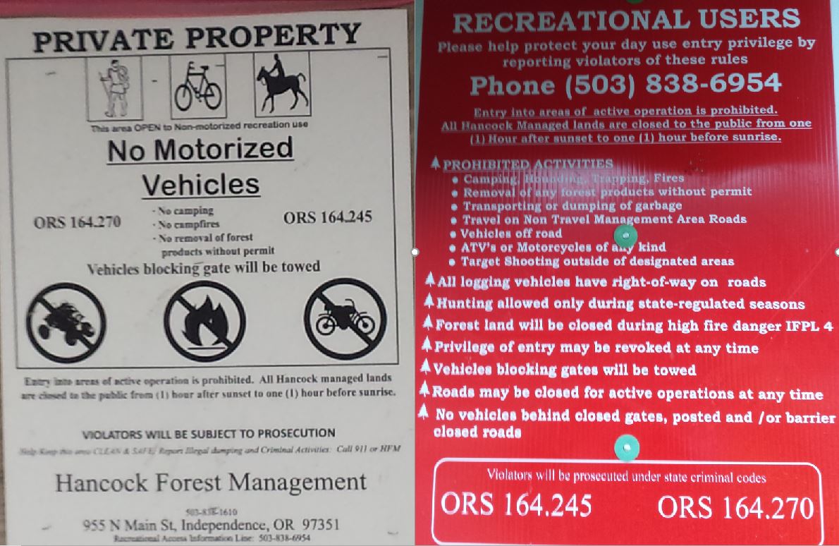
Sometimes they leave the gate open for logging traffic and contractors, even on the weekends.

Be like Alicia, earn your turns and you too can smile knowing your toiling will go towards keeping access un-compromised for future paddlers.

NOMENCLATURE
Jason Rackley started the naming scheme on Gladiator Creek, I tried to stick to the theme he started.
Romulus and Remus: The first couple slides that start the upper run. Romulus and Remus started Rome, which ended up being the naming theme for this upper section since gladiating occurred most famously in Rome and I ran out of applicable Gladiator terms.
Stout set of 4 drops: Whoever runs them first can name them.
Castrum Road: A castrum was a building, or plot of land, used by the Roman military as a fortified camp.
Triumfallades: A Roman Triumph was a huge parade sometimes given after a successful campaign that passed into the Pomerium (sacred part of Rome behind the walls). The Triumfallades on Gladiator are a parade of big falls and cascades, passing through two pillars into a place that is as sacred a place as any to me.
Pomerium: Meaning “behind the wall” in ancient Rome, it was a sacred open space located just past the Triumphal or Pomerium gates. On Gladiator it is the space past the large bedrock pillars that the Triumfallades pass through, surrounded by massive rock walls and only accessible through the gate.
The Skirmishes: A long section of continuous boulder gardens starting below the Pomerium and lasting to the middle bridge. The water was low for us during this section and while we only had one wood portage, there were plenty of other struggles navigating our loaded boats as we dodged wood, dealt with route finding, re-routing, rock-dodging, trying to stay studious about communication while keeping our eyes out for each other and downstream, along with pins, flips, traffic jamming, and deflections.
---
Vesuvius Falls: Mt Vesuvius was where the first battle of the third servile war (led by 3 Gladiators) happened, it is also the first notable obstacle on Middle Gladiator. To get down the mountain the slave army had to use ingenuity to create ropes and ladders out of vines, it also takes creativity and involves ropes or a leap of faith to portage this falls.
Ludi: Games in general, and festivals involving games and parades. These games could be private, public, or extraordinary, all things that are true of this parade of playful rapids that begin at the Rock Quarry access.
Venator: Venatores were skilled spearmen, usually pitted against carnivorous beasts. The hole at this drop is of the carnivorous variety, then the whole paddle/spear metaphor seems to work.
---
Arena: Named by Jason Rackley and Pete Giordano, presumably because you can watch the show from the bridge.
Punisher: Named by Jason Rackley and Pete Giordano, presumably because of the punishment this drop is capable of handing out, especially at high flows like they had.
Coliseum: Named by Jason Rackley and Pete Giordano, presumably for the high cliffs overlooking the drop on river right.
This stream has been an ongoing project for me, and required many scouting missions and saw a number of failed attempts, these people each helped with a piece of the puzzle: Rebecca Vogt, Sage Cruser, Tim Brink, Bruce (Ox) Reed, Pete Giordano, Jason Rackley, Rob Cruser, Dan Mccain, Ben Sigler (and his dogs), Bryan Carrington, Rick Cooley, Nate Merrill, Melissa Fowler, Rylie Coiteux, Jake Banta, Victor Repeto, Michael Freeman, Lucas Reitman, Willy Dinsdale, Ross George, Ben Mckenzie, Emile Elliot, Adam Edwards, and Joseph Hatcher.
-jacob
No comments:
Post a Comment