Beta
Stream: This is a short but sweet stream near Detroit. Nearly all the notable rapids have some bedrock component with an unusual amount (for Oregon) of scoured down bedrock slides and ledges. Wood is present, but if you pick the right routes there are no portages (as of Spring 2016, and still clean in Winter 2019). I usually do a couple laps when I'm up there, going slow and scouting the first time, saw in hand, then taking a second lap straight through.

After a short 1/4 mile hike along a game trail and a short off-trail descent to the creek (easy to follow in 2019) the trip begins immediately with a section of fun bedrock rapids. It's probably best to shore scout anything blind rather than read and run your first time down if no one knows the run.

After the initial barrage of bedrock there is a short manky section before things return to bedrock. Enjoy these fun slides but tread cautiously as about halfway down and around a blind right turn lies the largest rapid, The Venue. You need to scout before turning the corner or run center moving right at this short horizon line. Scouting/portaging/lapping is all convenient on river right.

*There is another corner above this one that seems like it could be the lead in to "The Venue", but isn't.
There are only a couple of small rapids between The Venue and Hallpass. The line at Hallpass is to enter right-ish and run the ledge/hole at the bottom center, keeping your nose up. The move is not too challenging but that hole is backed up and should be taken seriously even though it's not a visually impressive rapid. Safety is tricky but can be set.

Typical Boulder Creek

After a short 1/4 mile hike along a game trail and a short off-trail descent to the creek (easy to follow in 2019) the trip begins immediately with a section of fun bedrock rapids. It's probably best to shore scout anything blind rather than read and run your first time down if no one knows the run.

After the initial barrage of bedrock there is a short manky section before things return to bedrock. Enjoy these fun slides but tread cautiously as about halfway down and around a blind right turn lies the largest rapid, The Venue. You need to scout before turning the corner or run center moving right at this short horizon line. Scouting/portaging/lapping is all convenient on river right.
The Venue

Photo: Nick Hymel
*There is another corner above this one that seems like it could be the lead in to "The Venue", but isn't.
There are only a couple of small rapids between The Venue and Hallpass. The line at Hallpass is to enter right-ish and run the ledge/hole at the bottom center, keeping your nose up. The move is not too challenging but that hole is backed up and should be taken seriously even though it's not a visually impressive rapid. Safety is tricky but can be set.
Hallpass

Below here are more fun rapids, of all sorts. It can be a bit blind and fast paced, but when wood free is all good fun.

The bedrock ends abruptly just upstream of an island with a large log blocking the right channel.
From here, you have a couple options.
Option 1: You can continue working your way downstream. There is some wood to be dealt with, and the class III whitewater is all bouldery. If you are going for this route, my recommendation is to scout out the situation while running shuttle by walking upstream from the bridge on the overgrown road to scope out the Trash Collector, this small but problematic area will be obvious when you see it, a short distance upstream of the abandoned silo.
Option 2: Take out before the island with the log. There is a walk-able road on river right that leads to Hwy 22 near the bridge.

Option 3: Regardless of whether you took option 1 or 2, you can continue down to the North Santiam. Just be sure to look around the corner from the bridge over Boulder Creek before you paddle around that corner.
Once on the North Santiam it's a splashy class III big water ride down to the next bridge.

Flows: Our reconnaissance trips were done with the Blowout Creek gauge (The most relevant I believe) at just over 200 cfs, North Santiam blw Boulder Creek between 1500-2000 cfs, and the Brietenbush Gauge around 1,000 cfs. That was a safe level for exploring Boulder Creek's blind corners and long slides with small eddies, but was hard on boats and that's not a flow I go back for.
Iv'e been back at 350 on the Blowout Creek gauge when it rained the night before and had good flows.
Iv'e also run the creek at 700 and dropping when it hadn't rained the entire previous day and it was in but lower than the day at 350.
The best flow was 600 after a night of rain, and you could go higher.
It just speaks to the fact that the ballpark gauge is just that, a ballpark. If you aim for 500 cfs in Blowout, give or take a couple hundred after a night of rain your chances for enjoyable flows are good.
The good news is you can get a visual check before putting on. For our 2016 trips, water was just barely spilling into the trough on creek left under the Hwy 22 bridge. For a good medium flow, water was spilling over the rectangular support indicated below. The riverbed is comprised of boulders here, so don't be surprised if the streamed changes and this reference becomes obsolete.
*The creek will look low from the bridge, but if it looks like you can float your boat down here the creek should be at a good level.
Below is a visual guide to the visual gauge.
Exploratory flow: No water over rectangular support, but water is splashing into the trough.
March 6, 2016
Blowout Creek Gauge: 220 cfs

March 6, 2016
Blowout Creek Gauge: 220 cfs

A fun, low level: Water pulsing over the rectangular support.
April 28, 2017
Blowout Creek Gauge: 350 cfs

Medium: Water spilling consistently over rectangular support.
March 11, 2017
Blowout Creek Gauge: 600 cfs
March 11, 2017
Blowout Creek Gauge: 600 cfs

The Gist:
- If there is water on the rectangular support, there is enough water for the creek to be fun.
- High flows are undetermined.
- If water is not getting onto the rectangular support, you may still be able to run the creek if water is getting into the trough, but it will be scrapey.
After 5 trips to this creek, it's probably my favorite backyard style run in Oregon.
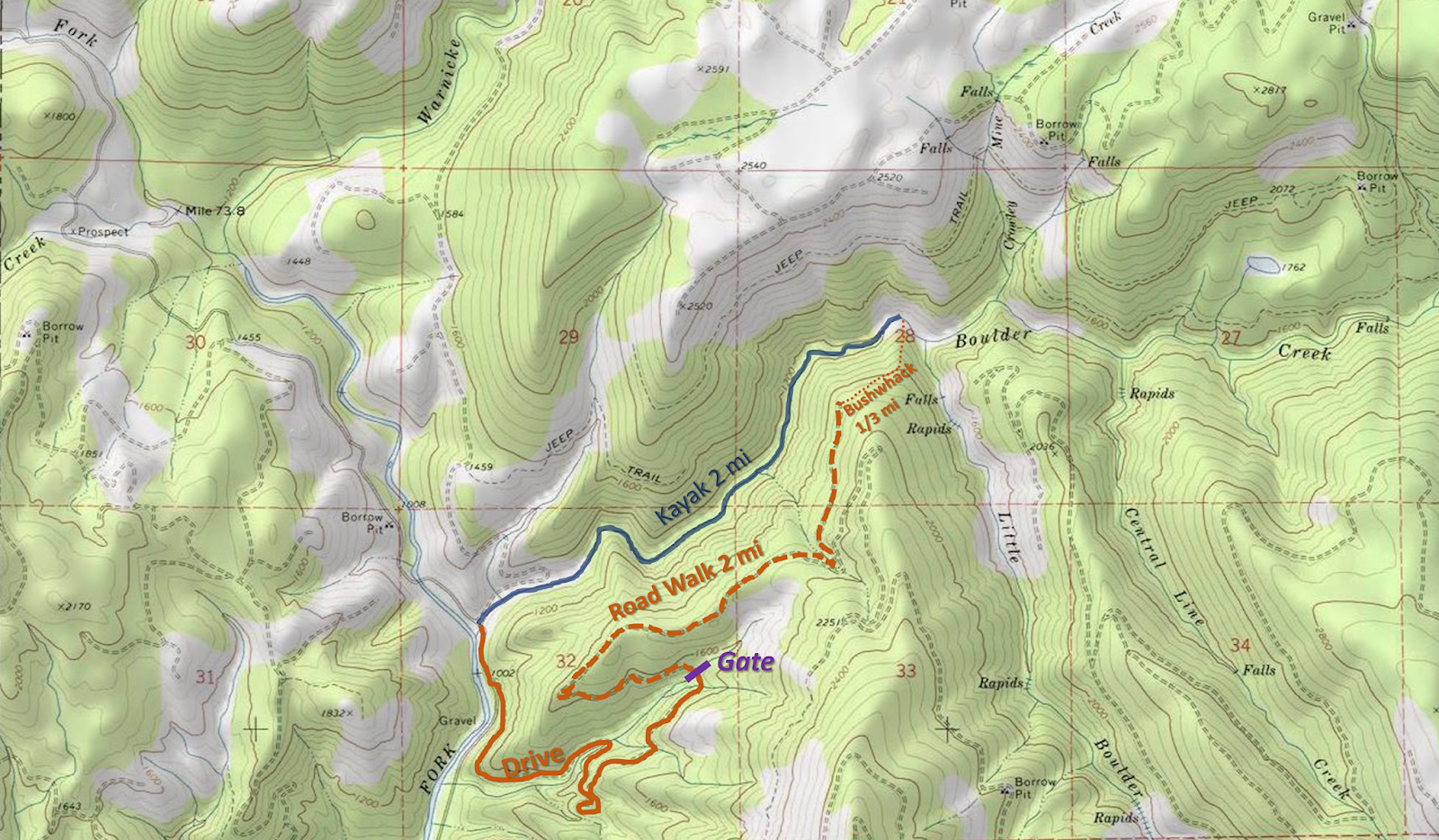
Access: Take highway 22 east out of Salem up to the town of Detroit. Within 5 minutes of passing Detroit you will cross the bridge over Boulder Creek (signed) near the town of Idanha. This serves as a place to leave a take out vehicle, check the water level, and scope out the Trash Collector. If you want to continue down the North Santiam, turn right onto Blowout Creek Rd and follow it to a bridge 2 miles after passing Detroit.
Photo pulled from google maps street view

To get to the put in return 0.3 miles toward the town of Detroit on highway 22 from the Boulder Creek bridge and turn right onto Boulder Ridge Rd/NF-2231. Travel 1.3 miles up this paved road to where it makes a sharp 180 degree turn to the left. Park near a yellow road sign before the turn and locate an overgrown road going off to the right, at the start of the 180 degree turn (50 yards past the sign). The trail was well marked in 2019 and easy to follow.

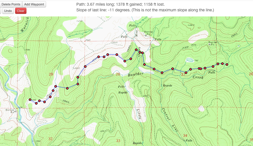
If you are reading this in the future and the trail is no longer in good shape, here is the general path: Walk the short distance along the overgrown road and follow the path of least resistance as it drops down from the road grade, then heads upstream quickly reaching an old game or logging trail at the far end of a scree slope. After about 1/6 mile on this trail, it splits at a small ridge. Take the steeper left trail over this ridge. For the most part the path has up to this point been close to flat, but about 100 yards after the ridge the trail gets steep, then very steep, at this point* veer off the trail to the right and follow the path of least resistance upstream (more or less maintaining elevation) over to another small ridge that is followed down to the creek. In 2019 the trail was all easy to follow.
*Where to leave the trail, from here cross-hill to the next nose of land and follow that down.

Put In 44.71, -122.0697

------------------------------------------------------------------------
Boulder Creek reconnaissance
------------------------------------------------------------------------
It took three trips, but we finally got the logistics figured out for this run. My first trip up there I didn't expect the creek to have any water and was just going to scout, but John Harmon sent me a couple photos from the take out bridge after he got off the nearby Bruno Mountain run on the North Santiam the day before. Looking at those photos I thought that maybe it might just barely be runnable so brought my rock boat just in case and planned on meeting Steve Tegtmeyer to run the Breitenbush if the new creek wasn't runnable. I scouted around a bit and saw a couple fun looking sections so when Steve Tegtmeyer showed up, we talked it over and we decided to give it a go. He and I had a nice trip, but flows were at exploratory levels and we put in below some of the good stuff. We had a couple portages near the end, so i decided to take out a little earlier the next time.
The second time there was a much larger group consisting of Ross George, Brandon Lake, Nick Hymel, Pete Giordano, Ben Mckenzie, Jesse Shapiro and myself. That time we decided to put in as high as we could float a boat in order to suss out the entire stream. We did that, with the upper section leap frogging between fun bedrock rapids and wood portages. It was a trying day, and the fatigue eventually caught up to us in the form of a dislocated shoulder in Hallpass. The information we gleaned from this trip provided the knowledge needed to get logistics dialed for return trips to this unique run.
Hiking in on the information gleaning mission.

I made a mistake about which spur road to hike in on despite having the correct information relayed to me. This meant we carried our boats further than necessary, dropping in on a tributary, meaning we began our trip with a couple extra portages.

There was some fun stuff in the upper reaches, but there were about as many portages as good rapids.


If this looks like fun, the upper section might just be your cup of tea.

photo: Nick Hymel
Eventually we made our final portage and had over a mile of fun bedrock rapids, some of which are visible on google imagery, which is what got me excited about the creek in the first place.

Halfway down the lower stretch we arrived at The Venue. Here there is a nice platform on the right where you can watch the show, from which you can then decide if you want to be a part of the show.
Nick Hymel, center-stage

*The Venue comes around a blind right corner that looks like the rest of the creek. If you turn the corner, you will be running the drop blind. Look for a couple small eddies on the right just before the turn with green flagging and a root wad on shore.
A short distance below The Venue lies Hallpass, where fatigue combined with a rocky lead-in to a backed up hole led to a swim and dislocated shoulder on our reconnaissance mission. Impressively the boater with the dislocated shoulder, who is no stranger to pain, paddled the rest of the run after popping the shoulder back in himself.
Hallpass
Downstream were a few more fun rapids before the take out we have been using. It is at the end of a long bedrock sliding rapid that splits at an island where the right channel has more water and ends in a ledge (there are a number of spots on the run that fit this description). Just below here the creek bends right with a couple eddies on the left along a wall. From one of these eddies ferry over to river right where there is a convenient take out. Downstream of here is a small log spanning the creek as the stream transitions to boulders for the duration of its course. From the take out eddy you can walk downstream and away from the creek to a flat area which can be followed a short ways downstream to the take out. Or you can paddle/portage the final 100 yards of the creek to the bridge.
Nick took some helmet cam footage during the reconnaissance mission that I put together.
For round three, I was able to locate an ideal put in that provides the most bang for your buck; with no portages and many bedrock slides and rapids including both of the named rapids. If you are looking for a longer day, you can walk from the take out described above on creek right down to the North Santiam River and get about a mile of splashy class III down to the Blowout Creek Rd bridge. There is a nice wave just above the bridge on river left that is fun to surf at the levels required to run Boulder Creek. The turn off to this bridge is about 1 mile back towards Detroit from the highway 22 bridge over Boulder Creek.
Trip two (photos from this report) was on March 6th, 2016
I think the Blowout Creek gauge will reflect flows the best in Boulder Creek.

I think the Blowout Creek gauge will reflect flows the best in Boulder Creek.


I would recommend a slow first lap to figure things out, then a second, faster lap. Or combine this run with Sardine Creek, French, Brietenbush, Secret Stash, Cedar, Bruno Mt, Opal stuff, etc.
-jacob